
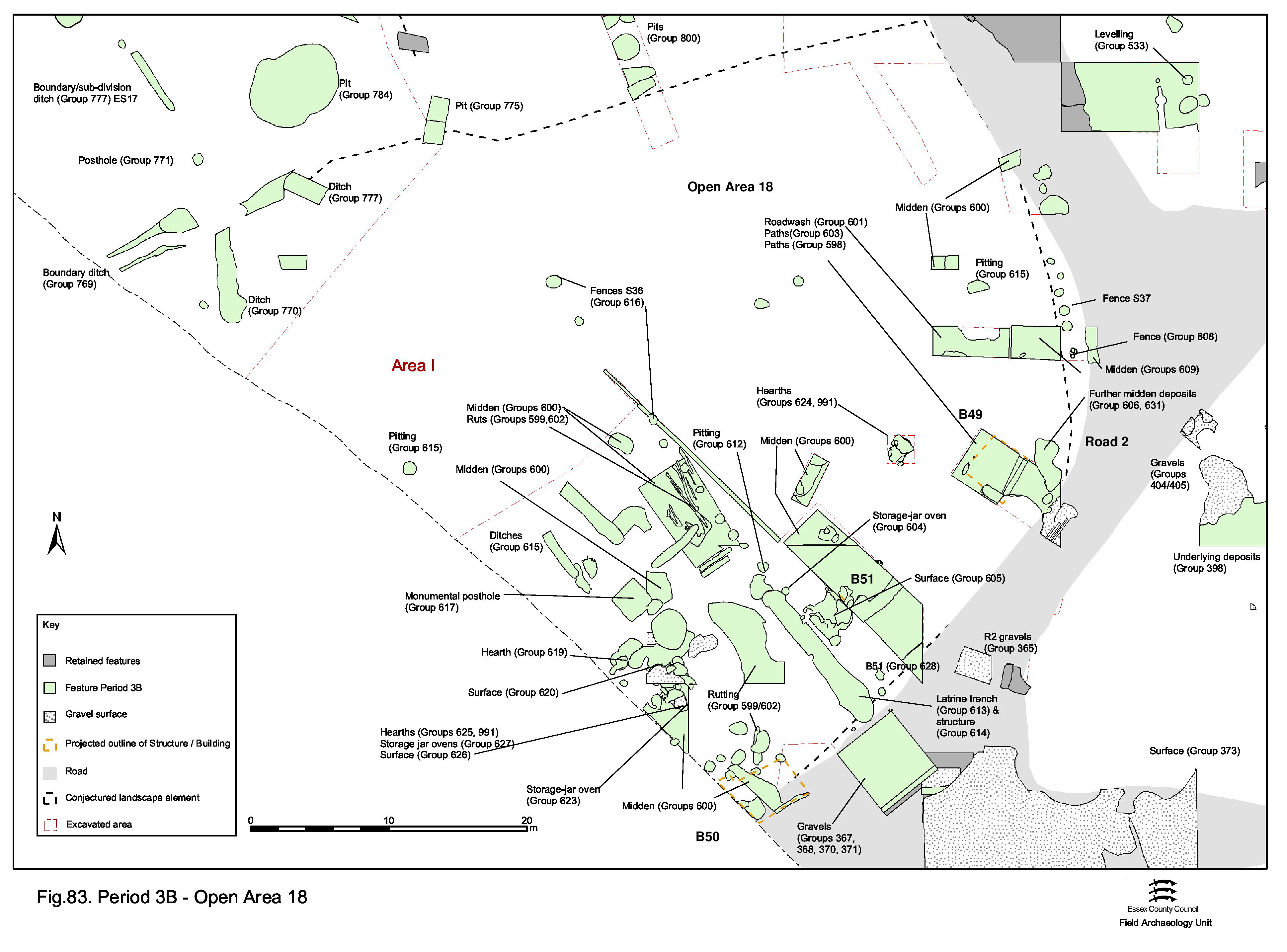
Following the concerted episode of dumping that marks the end of Period 3A and beginning of 3B in Open Area 18, this enclosure is re-occupied (Figure 83). However, the nature of this is markedly different from that of the Period 2B/3A roundhouses.
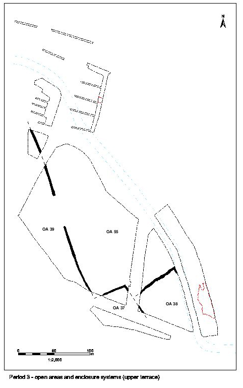
The imposition of a major fence-line (S36, see below) possibly bisects OA18 into two sub-plots. These are referred to as OA18(e) and OA18(w) henceforth. This section describes activity within the western sub-plot, while the eastern sub-plot is dealt with in the next section.
A total of twenty circular post-holes run on a NNW-SSE alignment across the middle of OA18 (Group 616, 5190, 5191, 5193, 5195, 5197, 5199, 5672, 5708, 5712/5880, 5714/13707, 13182, 13465, 13616, 13658, 13660, 18719, 21040, 21042, 21044, 21046). All are packed with clean orange clay and many contain clear post-pipes. Post-hole size varies between 0.5m and 0.8m diameter and between 0.4m and 0.6m depth. Post-pipes are generally 0.1m in diameter, though depths vary. All are fairly evenly spaced at 2.5-3m intervals with the exception of post-hole 5197, set closer to 5190. Many contain a higher than average pottery content for a post-hole, suggesting that sherds may be deliberately included in the packing material. They also contain a number of nails, possibly deriving from the structure of the fence itself.
Collectively, the post-holes form a roughly straight line that is traced for 40m north-westwards from the edge of Road 2. A slight change in alignment is evident either side of post-hole 5197. To the south of this the alignment is parallel with adjacent 'trench' 25049, while to the north they drift slightly more to the north.
These post-holes denote the position of a substantial wooden fence - Structure 36 - that probably extends northwards as far as east-west ditch 25015, thus effectively bisecting OA18. Dated to the early to mid-2nd century, and clearly cut through the silt dumps, it seems to represent the subdivision of the plot as part of its reoccupation following the raising of its land surface. Two eastern outliers, 18719 and 13465, similarly clay filled, are technically in OA18(e) and are further discussed in the next section
A number of slots, or the ends of small ditches (Figure 83), lie over and immediately south of defunct Period 3A boundary ditch 25120 (Group 593). Like their predecessor, these coincide with the underlying interface between gravel and natural brickearth and it is likely that their positioning is deliberate, hinting at a perpetuation of this division within OA18, despite the intervening dumping episode.
NNW-SSE aligned slots or ditches 25118 (seg. 13737) and 25119 (segs 13436, 13827) are parallel features that terminate at the same southerly extent. Their northern extents are not ascertained. Terminal fragment 13436 probably represents an earlier phase of 25119. Although containing contradictory ceramic dating evidence (i.e. 4th century AD), slot 25117 (seg. 13242) seems best suited as a Period 3B feature on the basis of alignment and perceived association. This 4.6m-long feature is located close to and parallel with 25048. It also appears to be positioned in relation to the square construction cut of the 'monumental post-hole' 13331 (see below). On the strength of this, its artefactual contents have been dismissed as contaminated (or more probably just mis-numbered), although it remains possible that the slot is structural and that the fills derive from the time of its disuse/destruction.
25118 overlies a NNE-SSW aligned slot, 25048 (segs 13438, 13739, 13819), which is shallow and broad with south-easterly returns at either end. These peter out as found, but perhaps originally extend further south. A structural function is perhaps likely, forming the northern end of a shallow rectilinear building of some sort. If indeed associated with slot 25117 and post-hole 13331 (see below), it could be open to the south - perhaps even denoting a shrine of some sort.
Post-hole 13331 is a vertical-sided pit some 2.4m square and in excess of 0.7m deep (Figure 113). Although disturbed by a later robber cut (13433), this foundation pit contains the impression of the base of a substantial post within a deposit of clean clay and gravel (13497) that lines the base of the cut and is used as packing around it. The vertical post is c. 0.4m in diameter at its foot - clearly a substantial piece of timber, although with an original foundation depth of only c. 1m it is difficult to believe that it stands to any great height (free-standing posts generally need to be planted to one-third of their total height). Material from its packing deposit indicates a mid-2nd century AD construction date. The post is subsequently removed in Period 4.
Given that it stands in a relatively open area of the plot and shares an alignment with such features as slot (shrine?) 25048 and 'trench' 25049, probably 'facing' Road 2, a civic, if not necessarily religious, function may be posited. Such 'monumental' posts are known from elsewhere, the most local being Ivy Chimneys, Witham (F1977, Turner 1999, 40). Its function need not necessarily be religious, perhaps serving as a marker post of some sort (cf. Alcester, Hemel Hempstead and Witham could be marker posts associated with a market).
Substantial and somewhat enigmatic linear cut 25049 (Group 613 segs 13756, 13901, 18155, 18697) is approximately 12m long and generally 1.8m wide with rounded terminals at either end (Figures 86 and 114). For want of a better term, it is referred to here as a 'trench' due to its near-vertical sides and flat bottom some 0.65m deep. Its northern end cuts earlier pit 18156 (Group 611, above), the fills of which apparently collapse into the trench as it begins to fill up, presumably following the trench's abandonment as a functioning feature.
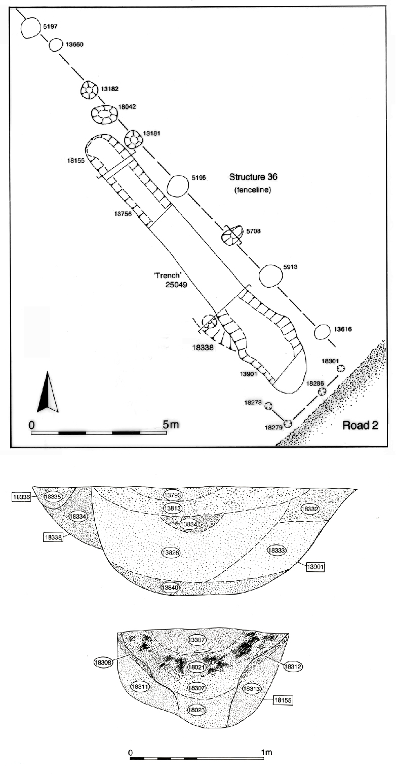
The trench fills vary along its length to some extent, although typically it contains lower fills of weathered yellow sands and gravels, derived from degradation of the trench sides, overlain by brown sandy silt backfill. It is likely that the trench remains open for a period of time. At its northern end (seg. 18155) one of the sand and gravel fills, 18023, is a dark, greenish-brown colour. It also contains an apparent re-cut in its top, which may be more plausibly seen as a secondary accumulation within a slump hollow. At the southern end (seg. 13901), the trench again contains green-brown sand 13826, but sand and gravel roadwash deposits, from adjacent Road 2, seal the top of the infilled feature.
The artefactual content of the trench is largely derived from its upper silt backfills and therefore relates more to disuse than to its primary function. These finds comprise moderate quantities of pottery, tile and animal bone, although the top fill of segment 13901 is notable for a 38kg dump of oyster shell (see section 4.4, Shell). The feature seems to pass out of use in the mid- to late 2nd century AD. The green hue of some of the lower fills may provide a clue to the primary use of the feature, possibly suggesting disposal of cess. It is tentatively suggested that this trench may be the remains of a latrine pit. The underlying natural gravel and sand presumably facilitate good drainage. If correctly interpreted, its substantial length would suggest that this is a communal facility. Its position close to Road 2 and to the religious focus may therefore be significant.
Clearly, trench 25049 can constitute only the below-ground remnants of a latrine. However, it is not unreasonable to suggest that it is enclosed, either wholly or partially, by a relatively flimsy wooden lean-to structure that employs the more substantial Structure 36 fenceline as its supporting rear wall. Further parts of this housing may be denoted by post-holes 18301, 18273, 18279 and 18286 (Group 614), which may denote a lesser fence enclosing the southern end of the trench, separating it from Road 2. However, there is no trace of screening between the trench and the mass of hearths and ovens only some 7m to its west (Groups 604, 623, etc., below).
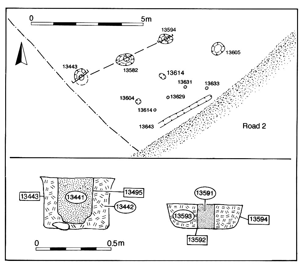
Building 50 is an insubstantial and tentatively identified structure that lies directly alongside Road 2, in the south of OA18 (Figure 87). It consists of narrow, but deep, slot 13643 (Group 621) and possibly post-holes 13594, 13582 and 13443 (Group 622), which may be construed to form parallel walls some 3m apart.
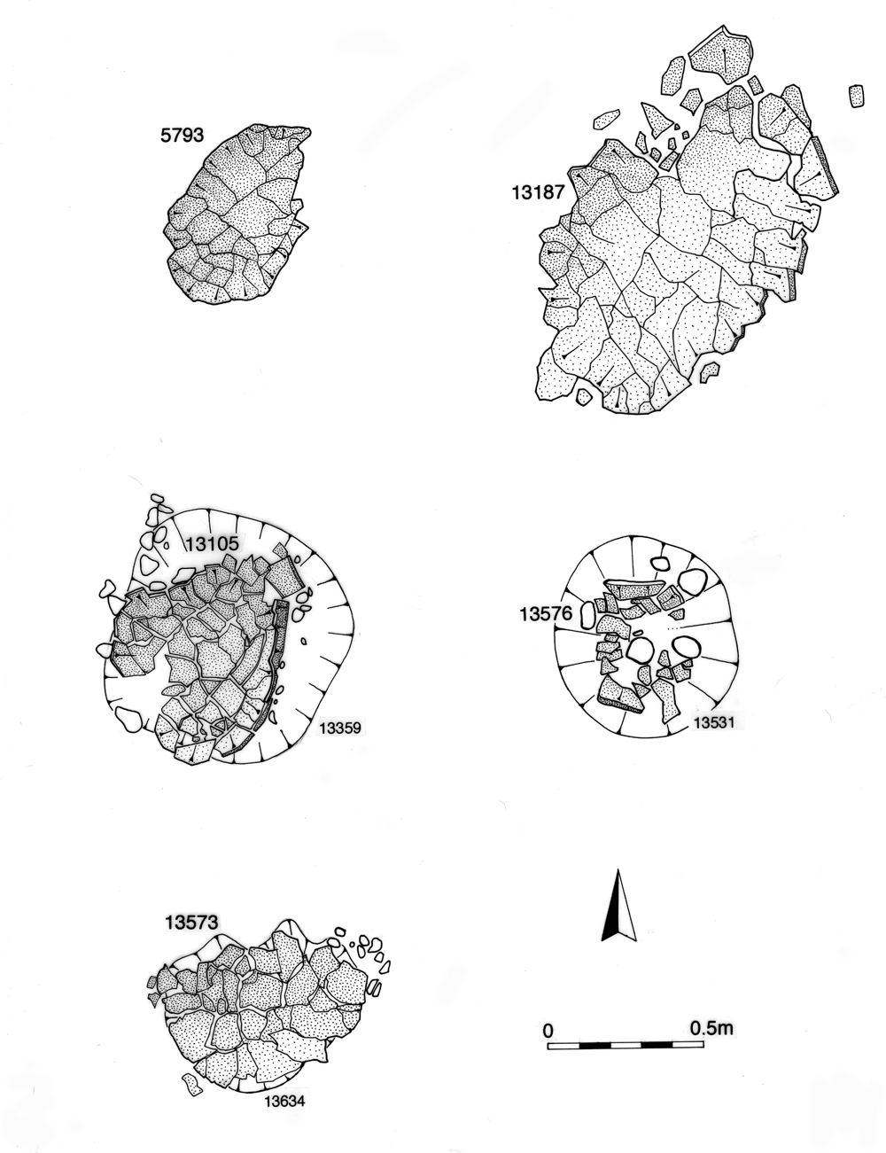
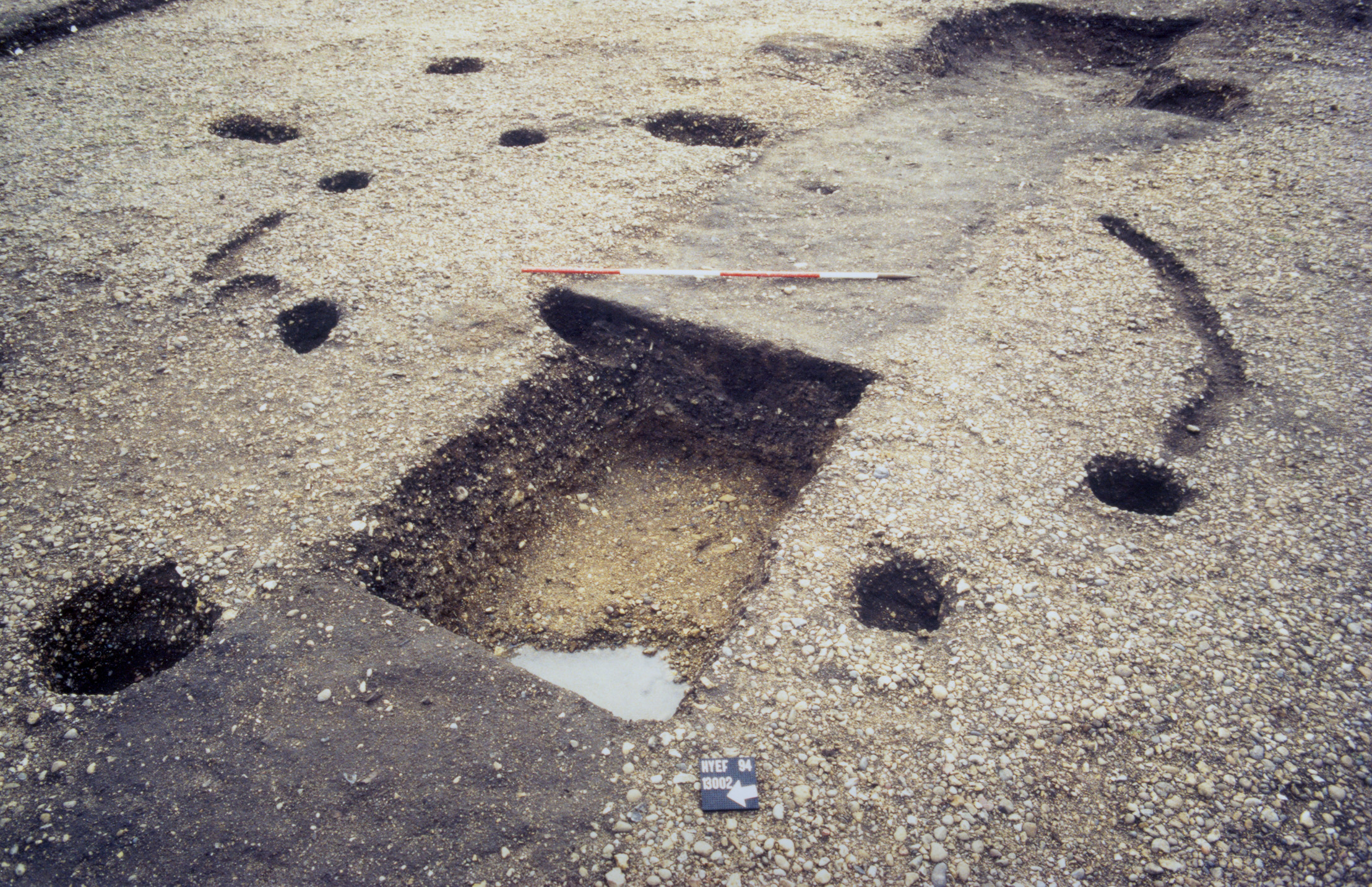
A quantity of storage jar ovens (see Atkinson and Preston (2015) for a wider discussion of their use and significance) and the bases of hearths were mostly encountered either during the initial cleaning of the exposed surface of the dump deposits, or else within them during their machine removal down to the underlying gravel surface. Some of the ovens, such as 13409 (Group 623), have been very disturbed both in antiquity and in the machining of the dump deposits. A selection of storage jar oven plans are presented (Figure 115).
As well as storage jar ovens, hearths of clay and/or cobble construction occupy the surface of the silt dumps and are intermingled with the storage jar ovens. Although some have again been disturbed and truncated, it is apparent that they are of either oval or sub-rectilinear form and tend to average a length or diameter of 0.7m. Fragments of clay and gravel surfaces occur in apparent close association with these hearths. Localised surfacing formed of orange pebbly sand-silt 13619, and cobbles set in pebbly silt 13215 (Groups 605 and 620), lie around hearth 13415 (Group 619). Compacted yellow-grey sandy clay deposit 13148 surrounds hearth 13149, while yellow-brown silty clay 13225 seems to be associated with storage jar oven 13187. Deposit 13407 is a spread of animal bone compacted into the dump silts surrounding hearth 13408 and partially covering adjacent hearth 13409. A similar range of possible surfaces surround other hearths. However, it is uncertain if any of these deposits constitute deliberate floors around these hearths and ovens or are simply the incidental product of trampling and compaction.
In addition, more ovens, hearths and/or fire pits of a more dubious nature are recorded as being present. However, being the least reliable, both in terms of their functional identification and the certainty of their stratigraphic position, these are only mentioned in passing here. Located among the cluster, these at least attest to a further intensity of cookery activity within OA18(w) during the earlier 2nd century.
Some hearths simply lie on or in the dump deposits (13023, 13412, 13456, 13457, 13460, 13493, 13494, 13600, 13602, 13618, 13728 Group 991). Further miscellaneous hearths (13149, 13311, 13454, 13458, 13504, 13533, 13570, 13609, 13670, 18638, 18641 Group 625) post-date some patchy surfaces (Group 620) but are apparently sealed by others (13148, 13225, 13351, 13407, 13413, 13455 Group 626), above which yet another phase of use is represented by further storage jar ovens (5846, 13187, 13359, 13521, 13531, 13634, 18634 Group 627).
As excavated in OA18(w), these hearths and ovens define a distinct cluster to the west of latrine trench 25049. Their inter-cut nature indicates frequent replacement, which is a feature of storage jar ovens elsewhere across the settlement; such structures presumably have a short life and require regular replacement and repair.
However, this close association of ovens and hearths is not apparent elsewhere. Their evident co-existence suggests that two methods of cooking are being carried out here, side-by-side. Furthermore, it is suggested that this activity occupies a dedicated space within OA18(w), delineated by monumental post 13331 and ditches 25117 et al. to the north, latrine trench 25049 to the east, and Building 50/Road 2 to the south.
Pits of early Roman date, post-dating the dumping episode, are notably rare - only two, both fairly small, are located within the excavated parts of Open Area 18(w). Pit 13845 contains a significant Dr 20 amphora component. Pit 18156/18157 is a rounded cut truncated by 'trench' 25049 (see above) and erroneously excavated as part of it.
Clearly, deposition of rubbish is not a significant activity carried out in OA18 during Period 3B.
Internet Archaeology is an open access journal based in the Department of Archaeology, University of York. Except where otherwise noted, content from this work may be used under the terms of the Creative Commons Attribution 3.0 (CC BY) Unported licence, which permits unrestricted use, distribution, and reproduction in any medium, provided that attribution to the author(s), the title of the work, the Internet Archaeology journal and the relevant URL/DOI are given.
Terms and Conditions | Legal Statements | Privacy Policy | Cookies Policy | Citing Internet Archaeology
Internet Archaeology content is preserved for the long term with the Archaeology Data Service (ROR). Help sustain and support open access publication by donating to our Open Access Archaeology Fund.