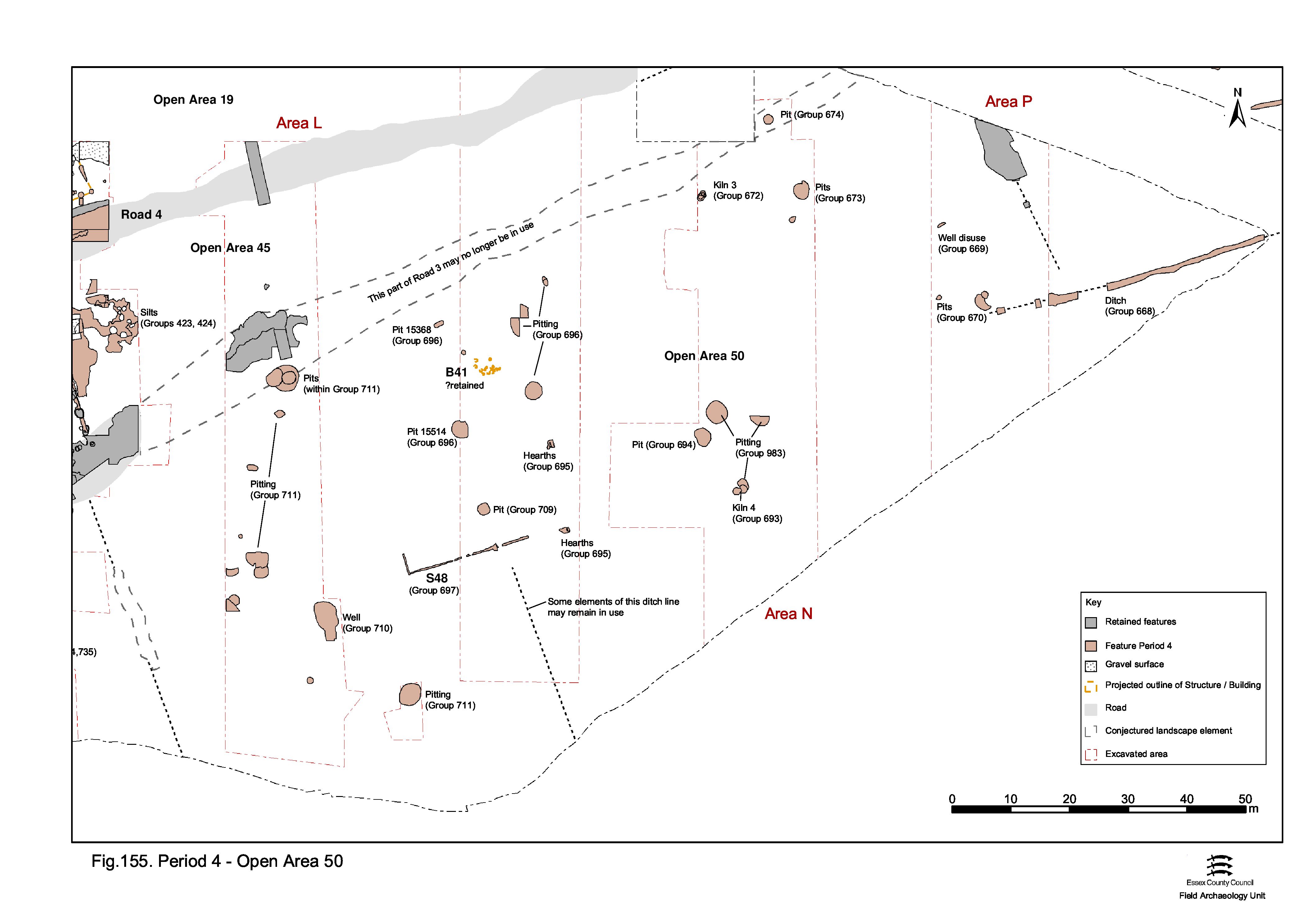
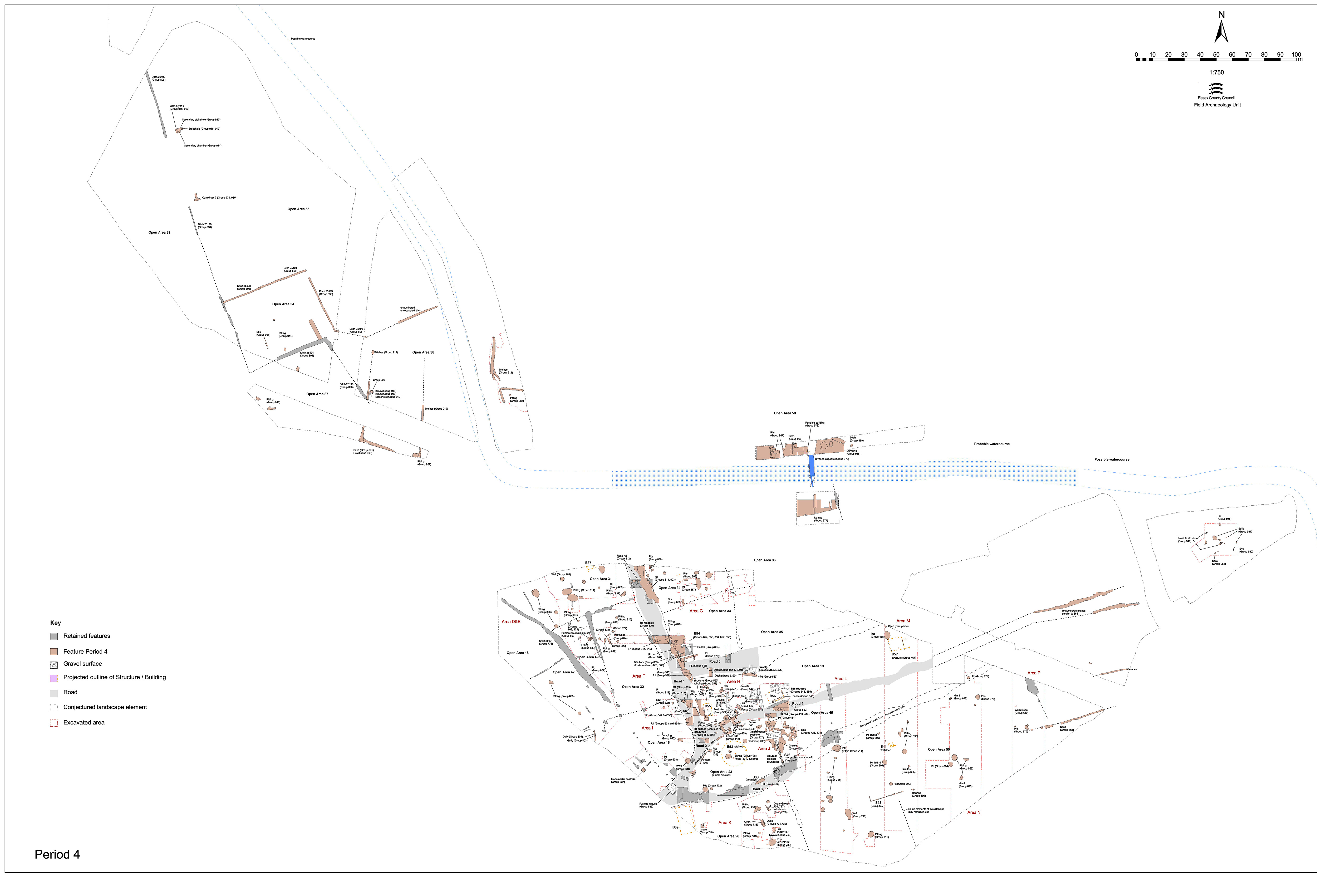
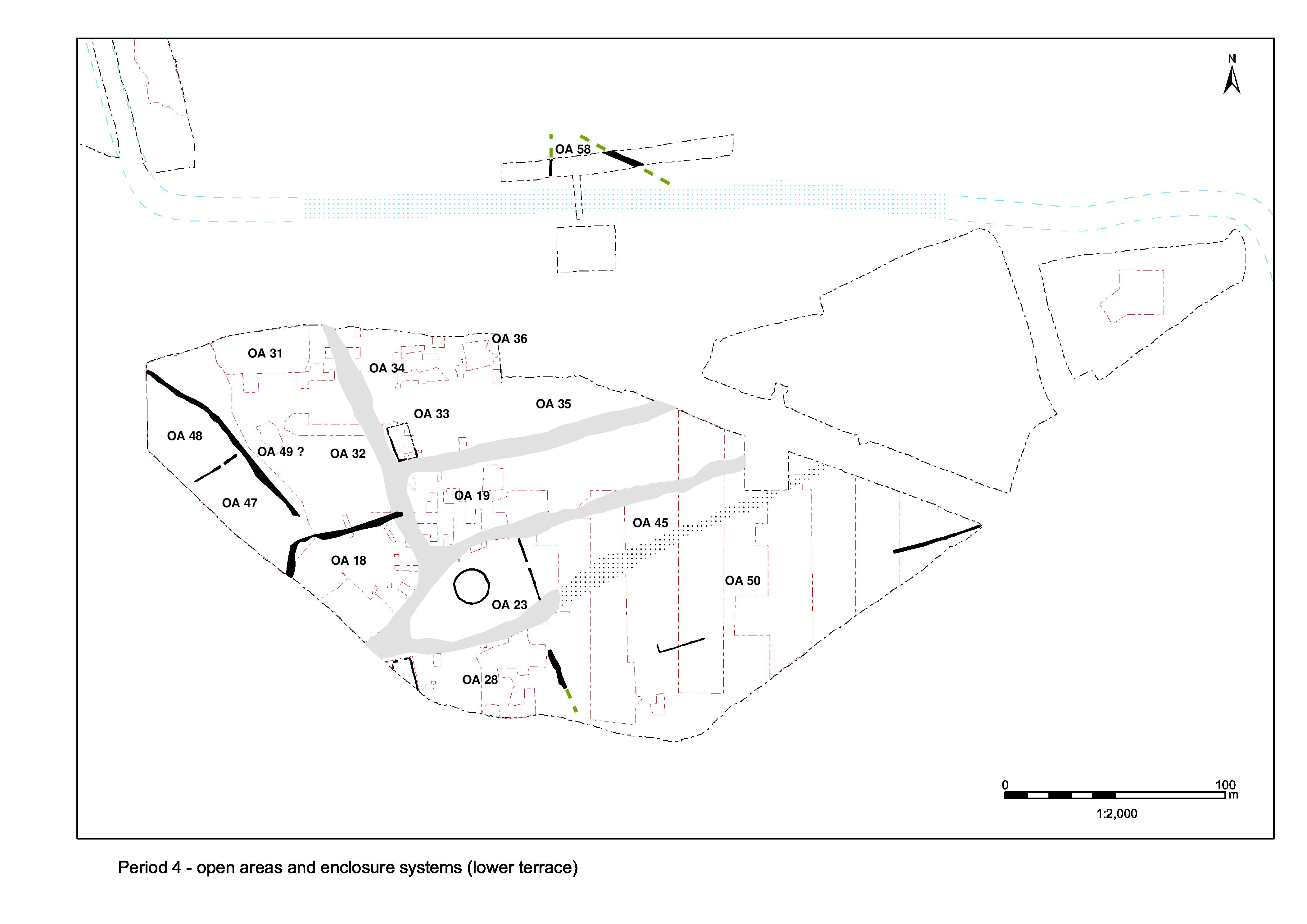
As the precise date of the creation of OA50 within Period 4 is unclear, it is possible that some of the mid-Roman features described below in fact pre-date it and therefore relate to latest activity within OAs 24-27. Nevertheless, all remains of later 2nd to mid-3rd century date occupying the Southern Zone (other than OA28) are described here (Figure 155). The quantity and distribution of features such as pits is so low as to provide little meaningful insight. However, well 8989 passes out of use by the end of the 2nd century, which might signal the abandonment of the Southern Zone as a place of occupation. While some of the OA24-27 Period 3 buildings might survive into the early part of Period 4 (Building 41) there is no evidence of them enduring beyond the imposition of OA50.
It is conjectured that the creation of OA50 brings with it a change in land-use, away from the ordered mix of horticultural gardening, processing and craft manufacture undertaken in and around the dwelling and towards a less enclosed, less structured, pastoral and 'dirty manufacture' function. The appearance of pottery kilns within the Southern Zone (as well as in the Northern Hinterland) is the most obvious result of this change of use.
Later Period 3 well 8989 (Group 662) probably continues in use until the later 2nd century, with a number of repairs being carried out to the clay lining following collapse and rebuilding of the upper part of the well (Group 669). The backfills mainly date to the late 2nd to early 3rd century and clearly show that the well ceases to function as a water source during the later part of Period 4. Instead, this convenient hole is evidently used for rubbish disposal, its finds assemblage being of similar composition to those of the contemporary pits to its south.
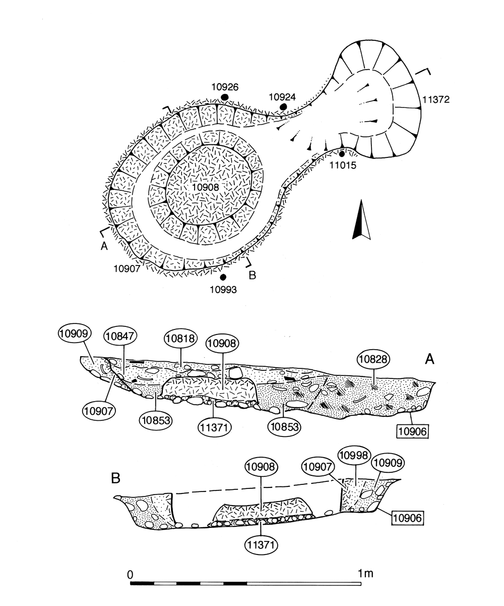
Oval construction cut 10906 contains the remains of a small kiln (Figure 159). Its sides are lined with baked clay, with an oval pedestal, 0.4m wide and 0.1m high, occupying the centre of the chamber and sitting on a 'floor' of fire-reddened compacted ?natural gravel. The lack of a clay floor around the pedestal may be due to its removal during raking-out. Four stake-holes 10924, 10926, 10993 and 11015, containing the carbonised tips of narrow stakes, indicated the presence of a framework supporting the kiln superstructure. Overlying burnt clay layer 10829 may be the remains of collapsed superstructure. The stoke-hole 11372 is a small circular cut on the east side of the kiln, some 0.6m wide.
No use deposits are identified within the kiln itself and, other than the baked clay of its construction, there is little evidence of burning. Though its morphology is that of a Wattisfield-type Kiln (Swan 1984, 115), at only 1.2m maximum width, this structure seems very small for a potter's kiln. It is perhaps more likely that it was used to fire other small items.
Pottery from the kiln construction deposits is securely dated to the early 3rd century AD. Archaeomagnetic samples collected from the clay lining were found to be unsuitable for dating. The disuse fills include pottery ranging from the mid-3rd to late 4th centuries AD and 109 iron hobnails.

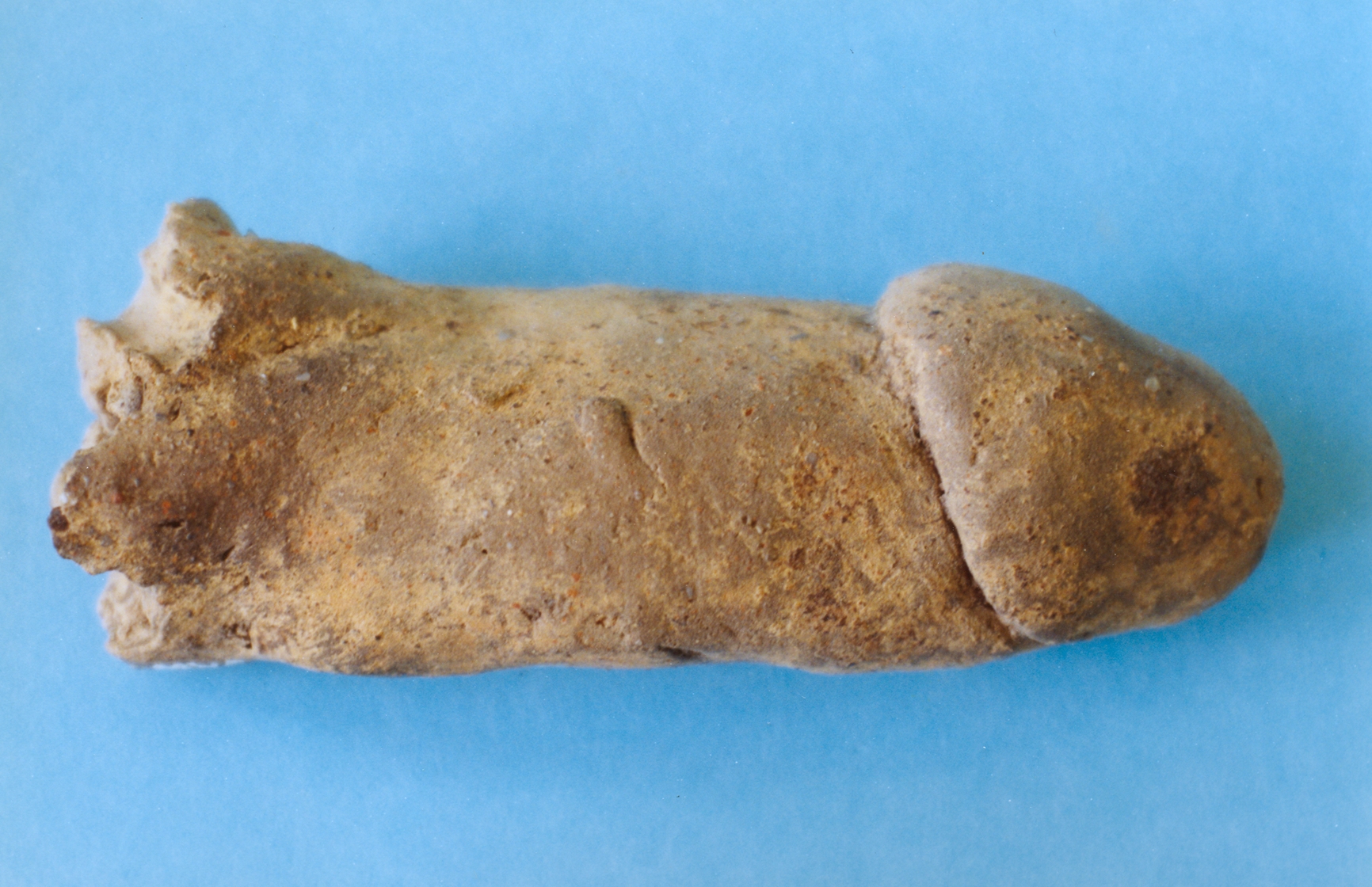
At the south end of Excavation Area N, a slightly oval construction cut, 11423, some 1.5m by 1.3m and 0.5m deep, contains a larger and better preserved kiln (Figure 158) than that of 10906. It is lined with walls of burnt clay of 0.10m to 0.15m thickness. The flue is located to the east, opening out into an oval rake-out pit some 1.6m long by 1.3m wide and 0.5m deep. Enough of the walls of the flue survive to determine that its arched entrance is repaired at least once with baked clay bricks. The kiln chamber is occupied by a central oval pedestal, 0.65m by 0.47m and 0.14m high. The chamber floor contains a charcoal-rich primary use deposit (11571), while overlying dark silts (11567 and 11559) also contain charcoal along with large fragments of kiln wall collapse. This structure is again a standard East Anglian Wattisford-type, pottery kiln (Swan 1984, 115), but neither the chamber nor stoke-hole appear to contain any remains of its products. In the absence of evidence for pottery production, the only other possible associated artefact is a clay phallus (SF7625) from stoke-hole fill 11597 (Figure 140).
Pottery from the construction cut backfill, dates the building of the kiln to the later 2nd century AD, while archaeomagnetic dating has produced a date range of c. AD 225-250 for its last firing (see 'Road 1 disuse - Period 5'). Disuse fills, containing rubbish assemblages, date to the mid- to later 3rd century, with some dumping/levelling continuing as late as the 4th century AD.
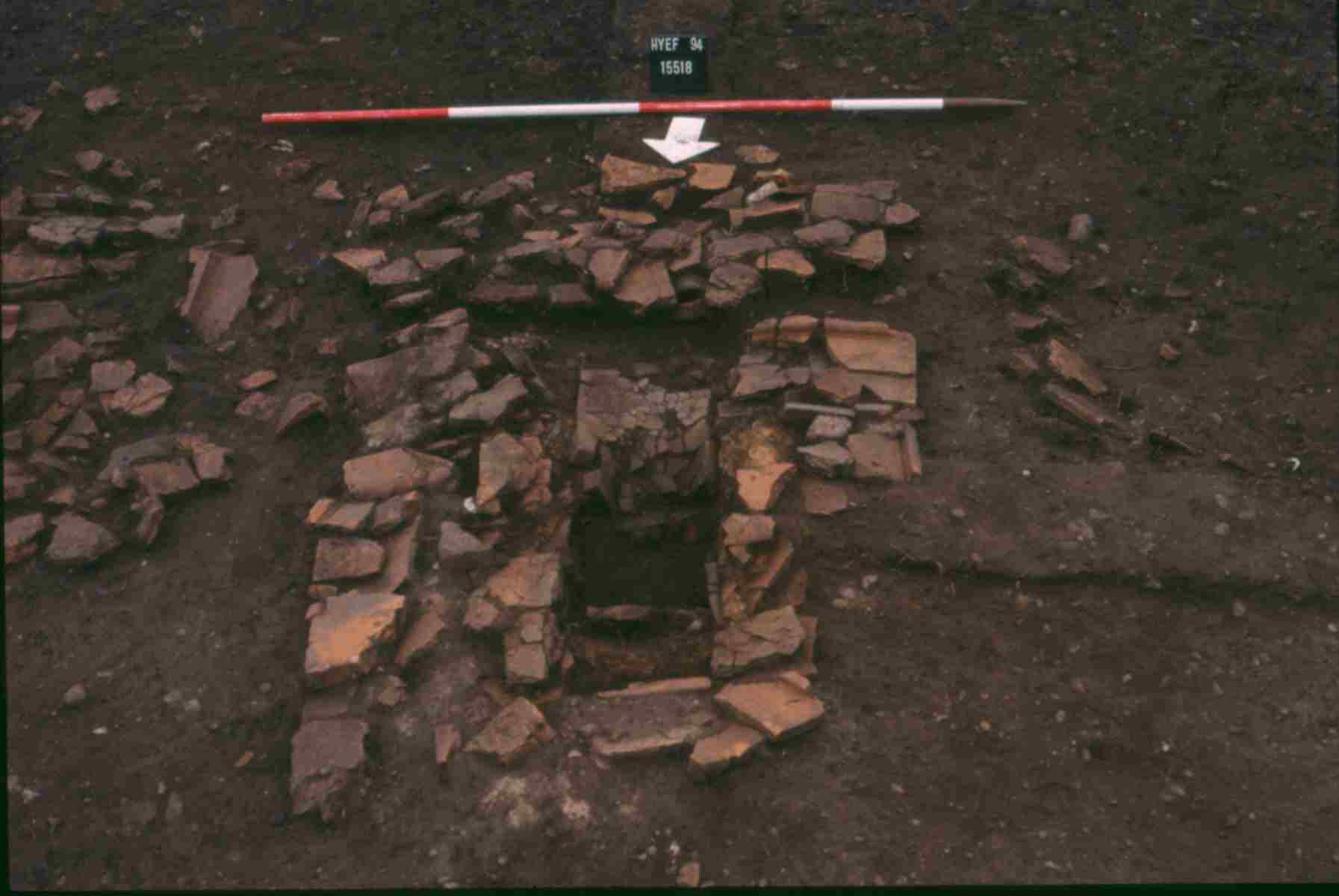
Hearth 15638 is the truncated remains of a tile-built structure (Group 695) encountered in Excavation Area M. Construction cut 15984 contains the base and lower walls of a 1.3m square tile-built structure (Figure 172). It is possibly L- or T-shaped when complete, but all that remains is the leg and hints of a corner, some 0.90m by 0.4m - giving the appearance of a flue for the (lost) main chamber. It consists of a floor of two tiles laid flat on a clay base, in a 0.20m deep cut, and walls of at least four courses of tiles (and some stone) also laid flat to line the sides of the cut up to ground level. Above ground level another course is laid overlapping the sub-ground courses and extending out onto the surrounding surface (which, by the way, presumably shows the level of the ground surface at this date, 3.24m OD). The structure contains some mortar but does not seem to have been fully bonded. There is a suggestion of some clay forming a facing, but it looks a rough-and-ready construction. The northern end is plugged with a clay seal, while an area of scorched clay (15893) at the southern end may indicate the position of the stoke-hole. The whole has a slight slope down from the north. Most of the surviving material represents collapsed superstructure, generally having been pushed or fallen to the south.
The remainder of the finds assemblage from the disuse fills and the collapse deposits (Group 751) is similar to those of surrounding pits and provides no clear evidence for the specific function of the structure, but it seems likely to be the flue for a probably more extensive above-ground construction such as a drying floor or hearth. The disuse material contains late 4th century pottery.

Well 14984 is an irregular oval, vertical-sided cut penetrating the natural gravel to a depth of 1.78m. At its centre is a square, plank-built shaft measuring 1.40m by 1.34m, around which a series of vertical supporting stakes (not recorded in section) are positioned (Figure 157). The cut is then backfilled around the wooden lining with orange clay. Integral to the construction cut is a 2m-wide ramp sloping down into the south side of the well. The ramp is lined with the same orange clay but it is unclear whether it remains in use beyond the construction phase.
Construction elements of this feature contain a small amount of 2nd century AD material which concurs with a dendrochronological date of the felling of the timbers in April/May AD 151 (see 'Roads 1 and 2 - Period 5'). No primary use deposits are identified within the well shaft, though this may be a result of the heavily waterlogged conditions in which excavation was undertaken. Fills within the well appear to date its disuse only, but do indicate that it was probably functioning as a water-source throughout the mid-Roman period and perhaps as late as the end of the 3rd century AD. The disuse of the well is described in 'Southern zone, Open Area 50' and the subsequent early Saxon reuse of this feature (see pit 14529, Group 722).
Later Period 4 pitting (as defined by either stratigraphic or dating criteria) is represented by only a small number of excavated features relative to the size of OA50 and suggest that that its occupation during the 3rd century AD is not intensive. It is noted that the pits tend to favour peripheral locations within Open Area 50 and to avoid the central part occupied by Structure 48, 25081, the hearths of Group 695 and well 11. For ease of description and location, these pits are dealt with by excavation area, from west to east.
The Period 4 pits (14442, 14520, 14599, 14611, 14715, 14758, 14933, 14940, 14994, 20019, 20138, 20185, 20225, 20308=20318 Group 711) tend to occur in tight, inter-cutting clusters, generally being rounded in plan and 2-5m in diameter. One of these clusters (pits 20308/20318, 21085, 20225), which encroaches on the line of Road 3, has been mentioned in the Road 3 description. Widely dispersed and isolated small pits such as 14442, 14994 and 20138 also occur, however. Apart from quantities of pottery and tile, finds assemblages within these pits are both less numerous and less varied than in the preceding period. Animal bone is present in reasonable quantity, but metalwork is very scarce. There are no copper-alloy artefacts and the only iron objects present are nails. A solitary possible litharge fragment (SF6277) in small pit 14994 is considered to be residual and not indicative of metalworking in this period.
Pits of mid-Roman date are few and far between in Excavation Area M (15368, 15514, 15731, 15811, 15826, 24197=15977, 24213 Group 696). The majority were large and circular cuts, some 2.0m to 5.0m in diameter, with only a few being oval and under 1m wide. As noted previously, large pit 15514 is located close to the line of boundary ditch 25081/25082 (Group 146), though this boundary is probably out of use by the time the pit is dug in the late 2nd or 3rd centuries AD. Small pit 15368 occupied a position close to the ?former line of Road 3; the only artefact from this pit is a large and fairly elaborate bronze flagon (SF2996), the deposition of which probably has a ritual significance (see Vol. 1, Chapter 6). This feature lies outside the sampled strip, however, so it cannot easily be placed in any clear stratigraphic context.
None of the larger pits were fully excavated: 15514 was more completely investigated than the remainder. It contained a larger and more varied finds assemblage than earlier pits, including quantities of ironwork and characteristically large amounts of pottery, tile (including voussoir) and animal bone. Approximately 8.5kg of oyster shell were also collected. Less extensive excavation of pit 24179 and surface only collection from 24213 produced correspondingly smaller finds assemblages. The small pits contained few finds. Pottery from nearly all of the pits included residual material, often in quantity, derived from earlier features through which they cut.
One pit (24072 Group 709) is separated from the remainder of the pitting because it may have been cut by ditch 25081 (see above)
Pits 10953, 10995 (Group 673), 11304 (Group 674) and 11361 (Group 680) vary in size but all contain significantly larger artefact assemblages than pits of the preceding periods in this part of the settlement. The groups are distinguished because pit 11304 is recorded as cutting 11361, though the latter is unplanned. Animal bone and ceramic building materials account for most of this increased artefact content; though smaller artefacts, particularly ironwork, are also more prolific. The pottery indicates a 3rd century date for the principal infilling of these pits. Only 10995 is likely to be filled by the middle of the 3rd century; the remaining pits continue to receive material well into the second half of the century and possibly into the 4th century AD. The late 4th century pottery in pit 11361 is, however, possibly intrusive.
Pit 23012 (Group 694) is a large irregular cut measuring 3.1m by 2.8m. Although not fully bottomed, it is probably not much deeper than the 0.6m excavated. Its fill sequence is relatively complex, and suggests a couple of episodes of deposition. Among the finds from fill 23020 is 5kg of animal bone, including articulated vertebrae, and two complete ceramic vessels. Other fills also include animal bone, together with quern fragments, a sharpening stone, unworked pieces of sarsen and septaria and 13.5kg of pottery. The presence of articulated bone and complete pottery vessels may indicate a ritual or structured element in the deposition of material within this pit - but not necessarily so. The pottery dates also suggest separate episodes of deposition, stretching from the late 2nd/mid-3rd century range of lower fill 23020 through the mid-3rd century date for middle fills 23019, 23087 and a later 3rd century date for top fill 23010. Some later pottery (late 4th century) is also present in the pit, but may be intrusive. It is tempting to draw attention to the fact that there is no later feature in this part of the site (i.e. the southern part of Excavation Area N), so that a deliberate closure rite on abandonment may be a possibility. If this did take place over the course of half a century or more, it would be all the more interesting.
The pits in Excavation Area P (8581, 8970, 19006 Group 670) are of varying size, but clustered around the end of ditch 25177. Once again a location close to a boundary seems to be preferred for waste pits. The finds assemblages from these pits are dominated by pottery, dated to the first half of the 3rd century AD, and tile.
Three conjoined pits (Group 983) date to the later 2nd to early 3rd centuries AD. Pit 11599 cuts Structure 32, and is cut by Period 4 kiln stoke-hole 11424. Pit 23024 cuts pit 23032 and pit 23118 probably cuts Period 3 Structure 33.
Internet Archaeology is an open access journal based in the Department of Archaeology, University of York. Except where otherwise noted, content from this work may be used under the terms of the Creative Commons Attribution 3.0 (CC BY) Unported licence, which permits unrestricted use, distribution, and reproduction in any medium, provided that attribution to the author(s), the title of the work, the Internet Archaeology journal and the relevant URL/DOI are given.
Terms and Conditions | Legal Statements | Privacy Policy | Cookies Policy | Citing Internet Archaeology
Internet Archaeology content is preserved for the long term with the Archaeology Data Service (ROR). Help sustain and support open access publication by donating to our Open Access Archaeology Fund.