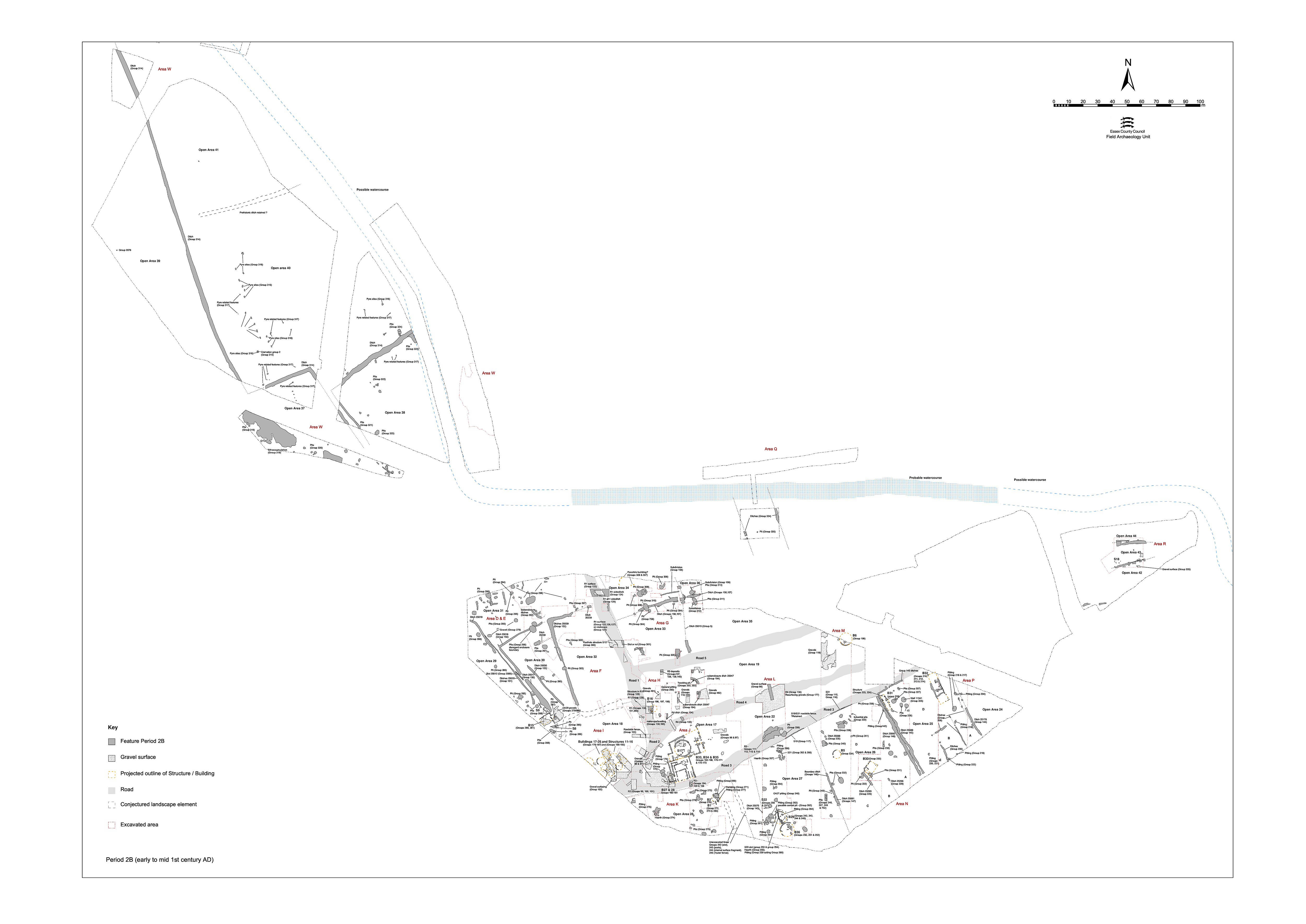
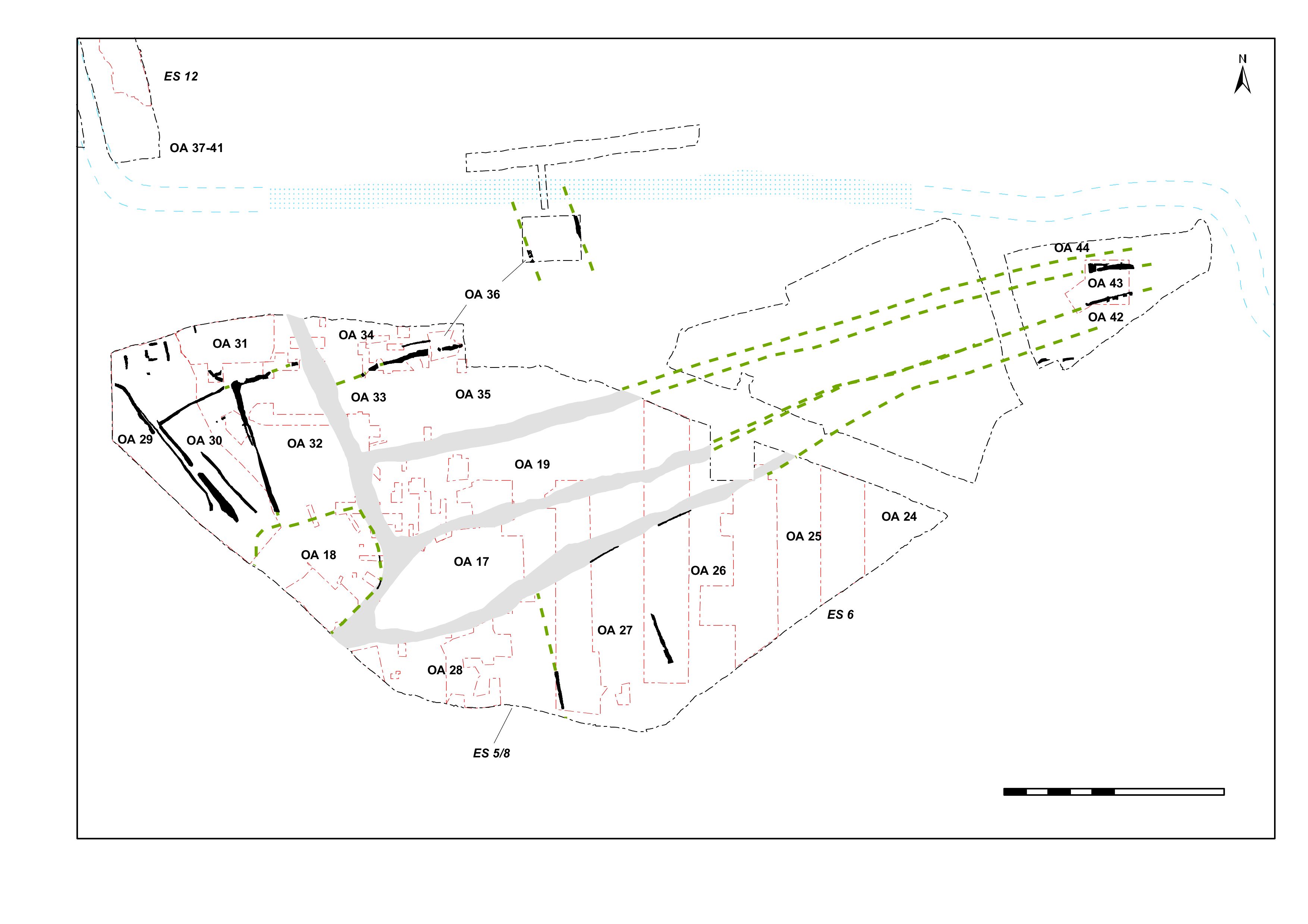
Following the imposition of the road infrastructure, the system of enclosure occupying the southern edge of the lower terrace (henceforth termed the Southern Zone) undergoes reorganisation (Figure 31). However, as the wide-scale topsoil removal and laying of metalled surfacing does not extend this far south, it appears that the new enclosure layout is as much a modification of the old as a replacement of it. Although the enclosures are now significantly shortened, only running as far north as the newly created Road/track 3, the alignment and quite probably some of the boundary ditches of the Period 2A system are perpetuated.
The southern zone enclosure system comprises a series of boundary ditches that define parts of five land entities that run east-west between Road/track 3 and the edge of the lower terrace. These are termed Open Areas 24-28. While the boundary features that define the enclosure system and its component units are described from west to east here, features indicative of their mid-1st century AD occupation and use are described separately.
To what extent the enclosure system is remodelled around and incorporating pre-existing Period 2A structures and features - particularly roundhouses - is far from clear. However, given the lack of successor buildings of unequivocal mid-1st century construction date, their continuance within the new layout is entirely possible. That said, where new buildings are constructed, they seem to be positioned toward the northern end of the enclosures, perhaps indicating that occupation now looks north onto Road/track 3, instead of south.
While the ditches described in this section clearly form a coherent system, it is less clear whether this system was imposed as one event or represents the culmination of a more gradual, piecemeal process. There is, for example, a clear distinction between the ditch defining the west side of Open Area 25 (Group 145), which turns and runs along the side of Road 3 to form the northern side of the enclosure, and the situation further west. Here, roadside ditches are apparently absent along the north sides of Open Areas 26, 27 and 28 and the roadside boundary is instead distinguished by fencelines.
The dating evidence suggests that the ditches are certainly present and filling up by the mid-1st century AD. The earlier date for ditch 25090 may indicate that parts of the northern boundary of the enclosure is infilled separately, perhaps as part of a widening of the entrance from Road 3. Of the fencelines along Road 3, only pottery from the fills of Structure 19 (20237 Group 117) provide a date, indicating that it is present (and possibly falling out of use) by the mid-1st century AD. This implies that that these land divisions are established prior to the Roman period. It is important to note that, despite the dating evidence for the filling of the ditches, there is no evidence of the disuse of these boundary lines (rather than the ditches or fences themselves) until Period 4. The absence of Period 3 features transgressing the boundaries is taken as evidence that the boundaries continue to be marked in some way, the ditches perhaps being replaced by hedges or fences and the roadside fenceline renewed.
Ditch 25075 (segs 14557, 14798, 14832, 14836, 14954) defines a major linear feature, 0.8-0.9m wide and 0.33-0.38m deep, running on a NNW-SSE alignment that can be traced for a distance of almost 18m. It is the most westerly of the investigated Period 2B boundary ditches (in Excavation Area K) within the southern part of the lower terrace, denoting the boundary between OAs 27 and 28. Its alignment differs slightly from that of its counterparts further east. Its fills contain a small but typical artefactual assemblage of pottery, animal bone and baked clay/daub of Late Iron Age date. It is possible that ditch 25075 is earlier than most of the other southern zone enclosure ditches, possibly originating as a component of the Period 2A landscape.
Ditch 25082 (segs 15526, 15992, 24428) lies approximately 60m east of 25075. It is traced for 11m before being lost among truncating features at either end. Its extant dimensions are a maximum of 0.9m wide and 0.25m deep. Much of its east edge is truncated by a later re-cut of the ditch line 25081 (segs 15527, 24070, 24429, 24430, 24442, 24445 Group 146). Its southern part is cut by Period 2B ditch/pit 15530 (Group 147). Late Iron Age pit 15968 (Group 141) is cut into the infilled 25082 prior to it being replaced by 25081.
Overall, this ditch is assumed to mark a boundary that runs from Road 3 to the edge of the lower terrace, separating OAs 26 and 27. Suggestions of its southward continuation beyond ditch/pit 15530 can be discerned on the pre-excavation plan and a tentative alignment of post-holes toward Road/track 3 might represent its northward continuation as a fenceline.
A problem arises, however, with re-cut ditch 25081 (Group 146). Topographically, the ditch should belong to the early planning of the site. However, the excavated evidence from this ditch consistently features later 4th-century pottery and late Roman coins. There is no suggestion that this boundary falls out of use until it is cut by Structure 48 (Group 697 Period 4) in the late 3rd century AD. It may be that 25081 demonstrates the perpetuation of this boundary as a hedge or fenceline against which later material accumulates. Even so, its chronological relationship with Structure 48 is uncomfortable; some error in the recorded sequence seems likely. It should be noted in passing that some late Roman pottery and an apparently Roman iron tool (SF6650) are also present in ditch/pit 15530 (below).
Although only partially excavated, the rough extent of ditch/pit 15530 is apparent on pre-excavation plans, defining it as at least 25m long, and as a southward extension or perpetuation of the alignment of 25081/2. It is likely that much of this feature is actually a continuation of re-cut 25081. Most of the excavated fills of 25082 contain early to middle 1st-century AD pottery (although seg. 15992 includes 4th-century material that is deemed to be intrusive).
Roadside ditches are absent along Road/track 3. While the western end of Road 3 is substantial enough to distinguish the edge of OA28, the northern boundaries of OAs 26 and 27 are instead marked by fenceline Structures 19 and 31. Given their intangible nature, it is not clear whether these intermittent foundation slot remains represent a once-continuous or intentionally interrupted fenceline.
Structure 19 is represented by slot 25155 (seg. 20237 Group 117). As investigated within Excavation Area L, it is traced for a distance of 15m along the OA27 frontage. Its perceived western terminal tentatively cuts Period 2B pit 20195, while its eastern end coincides with the boundary between OAs 26 and 27.
A c. 16m length of fenceline foundation slot 25160 (segs 15452, 15455 Groups 115, 116) is investigated within Excavation Area M. The slot contains post-holes 15451, 15453, 15454 and 15456 in its base. As recorded on the pre-excavation plan, this boundary can be construed to be more extensive, perhaps continuing westwards along the OA26 frontage to the boundary with OA27. The plan also suggests the presence of an otherwise uninvestigated slot-built building occupying this part of the OA26 frontage - perhaps integral with the fenceline, though possibly replacing it.
Ditch 25089 (segs 11200, 11258, 11462, 11489, 11529)/25090 (segs 10804, 10882, 11062)/25091 (segs 10824, 11100, 11264) can be seen to run the whole distance between Road 3 and the terrace edge, some 60m west of 25082 and 25081. It turns to run along the edge of Road/track 3, marking the presence of a definitive northern roadside boundary to OA25.
On the western side of the enclosure, ditch 25089 is on average 0.8m wide and 0.34m deep. At its northern end it makes a right-angled turn as ditch 25090 and continues as ditch 25091 along the road/track side. There is a gap of less than 1m between 25090 and 25091, presumably denoting a minor entrance; post-hole 10849 could constitute the remains of a gate structure at this point.
Most of the excavated ditch segments are filled with a single sandy silt and gravel deposit, and generally contain assemblages of pottery, daub, baked clay and briquetage. The fills of ditches 25089 and much of 25091 can be dated by pottery to the mid-1st century AD. That from 25090, devoid of Romanising wares, belongs to the early 1st century AD. Its eastern terminal (seg. 10882) contains a greater quantity of animal bone (2kg) than elsewhere along its length, together with loomweight fragments and a quantity of pottery. It is possible that this is a structured deposit within the ditch.
The most easterly of the identified north-south aligned boundaries of the southern zone enclosure system is ditch 25178 (segs 8704, 8763, 8839, 8881, 19155), exposed for a distance of 34m. Where investigated within Excavation Area P it is 0.9-1.2m wide and 0.28-0.45m deep, and clearly represents a major land division marking the boundary between OAs 24 and 25. Material from its single fill dates principally to the earlier 1st century AD. Lying beyond the limit of the site, the relationship of this ditch with that of 25089/25090/25091 is not determined, nor is the eastern side of the enclosure readily apparent in the pre-excavation plan of Development Area A3.
Internet Archaeology is an open access journal based in the Department of Archaeology, University of York. Except where otherwise noted, content from this work may be used under the terms of the Creative Commons Attribution 3.0 (CC BY) Unported licence, which permits unrestricted use, distribution, and reproduction in any medium, provided that attribution to the author(s), the title of the work, the Internet Archaeology journal and the relevant URL/DOI are given.
Terms and Conditions | Legal Statements | Privacy Policy | Cookies Policy | Citing Internet Archaeology
Internet Archaeology content is preserved for the long term with the Archaeology Data Service (ROR). Help sustain and support open access publication by donating to our Open Access Archaeology Fund.