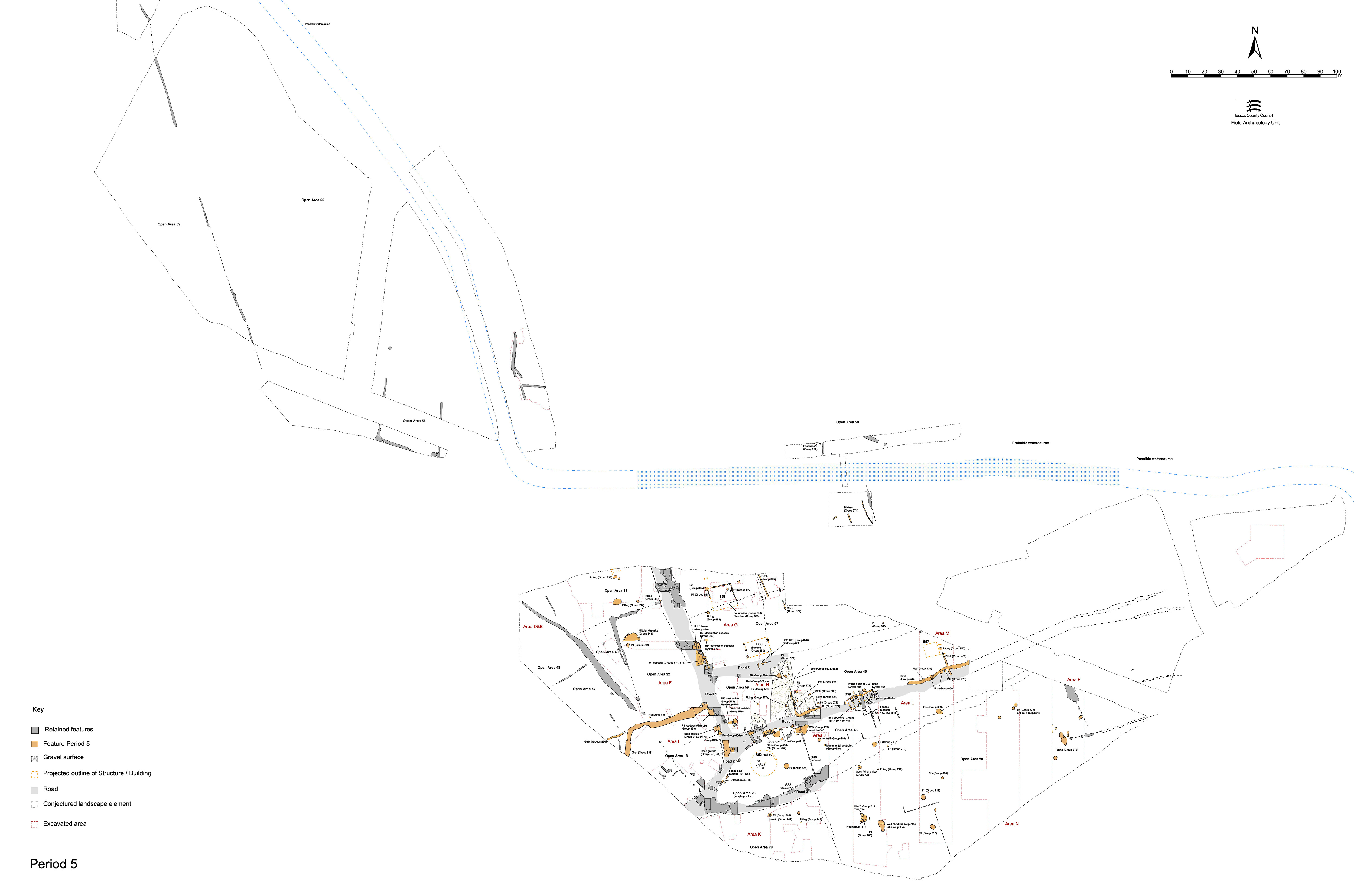
Of the side roads off main thoroughfare Road 1, only Road 4 shows any tangible sign of maintenance and use - albeit limited to its western end off Road 1 (Figure 178). Even the continued use of Road 4 is short-lived in Period 4 when it unequivocally becomes defunct with the siting of post-built Building 59 upon it.
There is no evidence for Late Roman maintenance of Road 3. Indeed, pit 20193 (Group 718) encroaches upon the line of former Road/track 3, further suggesting its disuse.
The latest identified use of Road 4 is represented by deposits 5396, 5489, 5499, 5827, 5850, 6128, 6129, 16308 (Group 434). These less compact layers, largely gravelly silts, probably represent both repair to and weathering of the surfaces, indicating degradation of the road through its continuing use during Period 5. Even the more substantial of these layers (6129, 5396, 5489, 5850) are loose and broken, with a significant silt component. Layer 16308 may be the result of the degradation of road surface 16292 (Group 413 Period 4). Layer 5499 contains an iron lynch pin (SF3206), presumably derived from the traffic using the road.
Some gravel deposits, such as narrow, 2.5m-wide, 6129, may simply augment earlier surfaces. The addition of 6129 could perhaps supplement and widen Period 4 surface 6130 (Group 417) to a width of 6-7m and continue its use into the Late Roman period.
This phase of use seals the Road 4 fence 6061 et al. (Group 549) and therefore post-dates Road 4 surface (Group 417 Period 4). However, the relationship of these deposits with Period 4 road-wash Group 556 may have been confused on site, as the latter appears to overlie them as recorded. At its junction with Roads 1 and 2, this phase of Road 4 merges into Road 1/2 surfaces (5761 Group 643) and underlies further Road 1/2 surfaces (Group 644). Most of the dating from this sequence is poor but the Group 644 deposits date to the second half of the 4th century. It is possible, therefore, that Road 4 continues to function throughout the 3rd century and perhaps into the 4th century AD, albeit in a rather ad hoc state.
The re-cutting of what superficially appears to be the Road 4 northern roadside ditch may occur at this time (Figure 177). Only the ditch cuts are treated as being within this period - the fills (Groups 651, 652, 653) all clearly date to its disuse in Period 6.
The westernmost portion of this extensive feature, ditch 25260 (segs 16185, 16231, 16338 Group 584) is investigated in Excavation Area H. It runs from a rounded western terminal (which coincides with the southern end of Structure 44 Group 567 Period 5) for at least 15m before continuing into an unexcavated part of the site. It is relatively broad and shallow, averaging 2m in width and only 0.06-0.25m depth. It appears to define the northern edge of Track 4 and is clearly associated with the boundary represented by Structure 44. The eastern end of this part of the ditch line is probably represented by rounded, bulbous, terminal 25262 (seg. 20762=20814 Group 466) excavated in Excavation Area L. 25262 is 1.8m wide and 0.35m deep. After a gap of c. 2.5m (which coincides with the position of the west end of Building 59), the eastward continuation of the ditch line resumes as 25077 (segs 20569, 20751, 20754 Group 466). 25077 is very shallow cut, 0.9m at its widest and a maximum of only 0.13m deep. At its western end it is only 0.08m deep and ends in a tapering, rounded, terminal.
The most easterly excavated portion of the ditch is recorded as 25078 (segs 15049, 15102, 15107, 15223 Group 473) in Excavation Area M. 25078 was a sinuous ditch which cuts two small, round or oval pits (15068, 15241 Group 470). Segments across it revealed a variation in width between 1.5m and 2.0m and an undulating base which reaches a maximum depth of only 0.4m. Both its origin and subsequent 'life' seemed to be bound up with a number of latest Roman pits which underlay, cut or flanked the ditch. It is likely that the irregularity of this feature is due to its imposition along a line of pre-existing, though already backfilled, pits (e.g. pits 15068, 15241 Group 470) which are themselves located alongside Track 4.
As with Road 3, there is no evident upkeep of Road 5 in the Late Roman period and beyond. Encroaching Structure 51 and pit 7435 would seem to confirm its redundancy.
Internet Archaeology is an open access journal based in the Department of Archaeology, University of York. Except where otherwise noted, content from this work may be used under the terms of the Creative Commons Attribution 3.0 (CC BY) Unported licence, which permits unrestricted use, distribution, and reproduction in any medium, provided that attribution to the author(s), the title of the work, the Internet Archaeology journal and the relevant URL/DOI are given.
Terms and Conditions | Legal Statements | Privacy Policy | Cookies Policy | Citing Internet Archaeology
Internet Archaeology content is preserved for the long term with the Archaeology Data Service (ROR). Help sustain and support open access publication by donating to our Open Access Archaeology Fund.