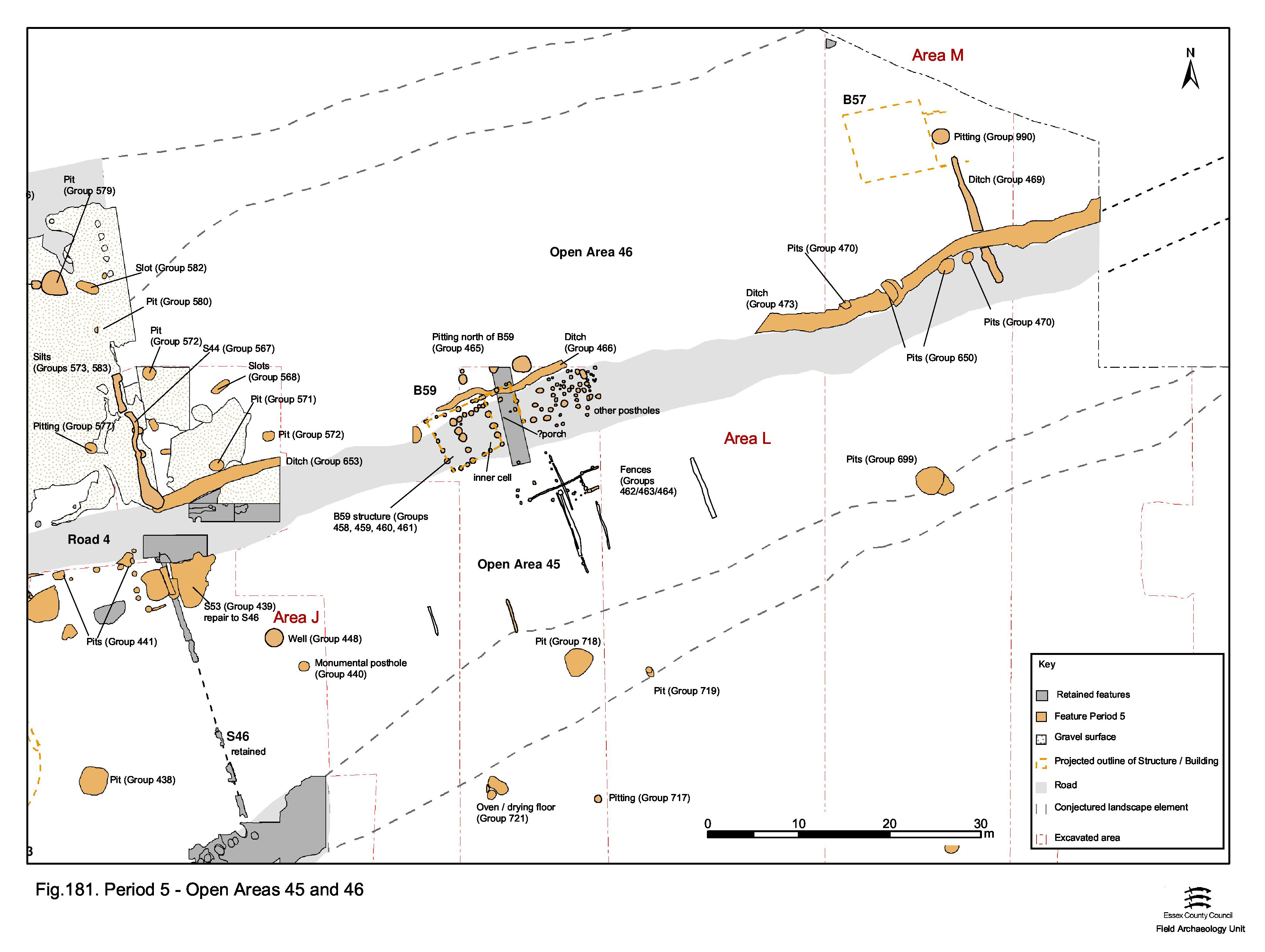
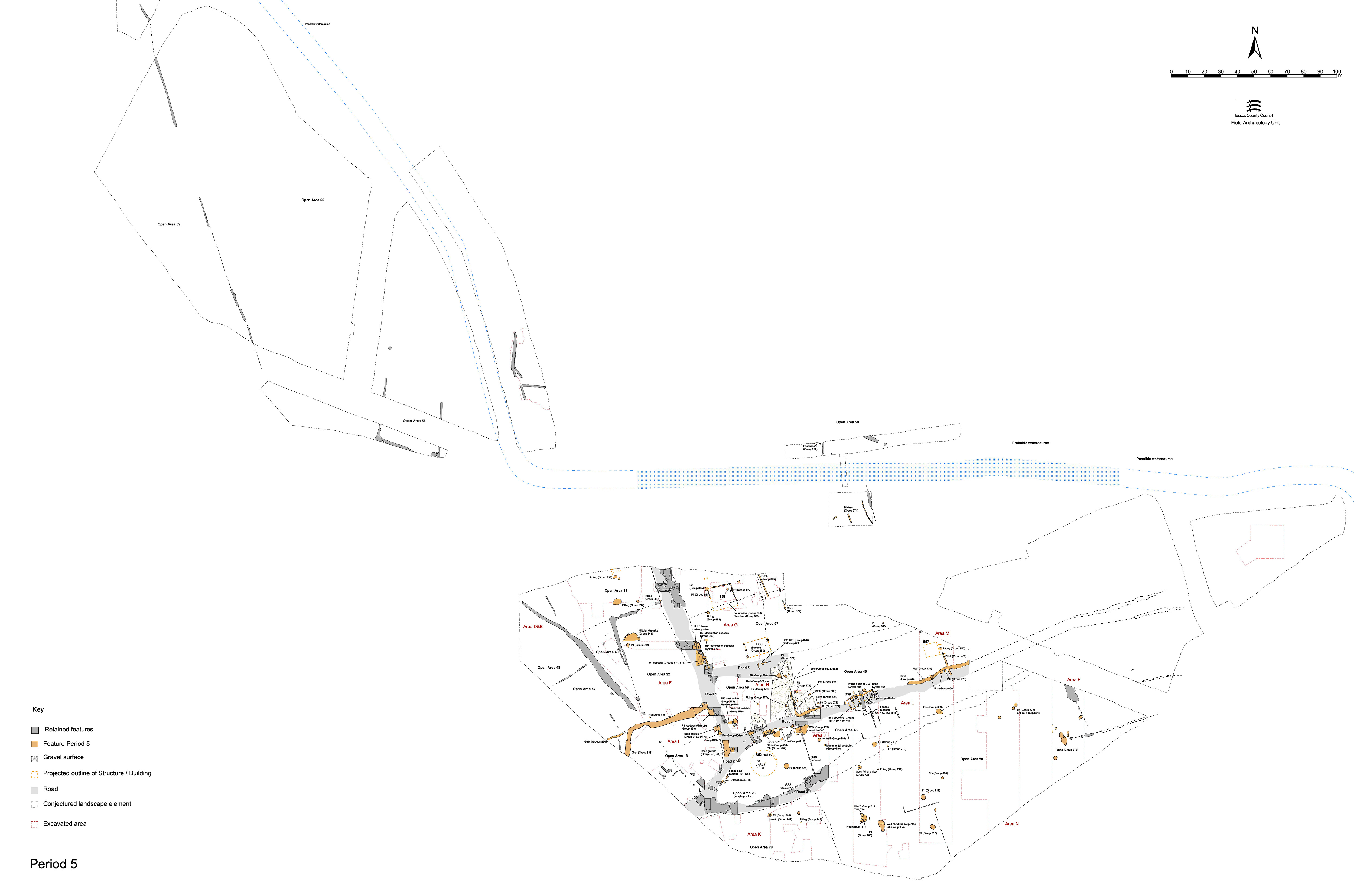
That part of Road 4 to the east of the temple precinct passes out of use during Period 5.Open Area 45 is held to be extended northwards so that it now includes the line of the defunct Road 4, with ditch 25260/25262/25077/25078 marking the boundary (Figure 181).
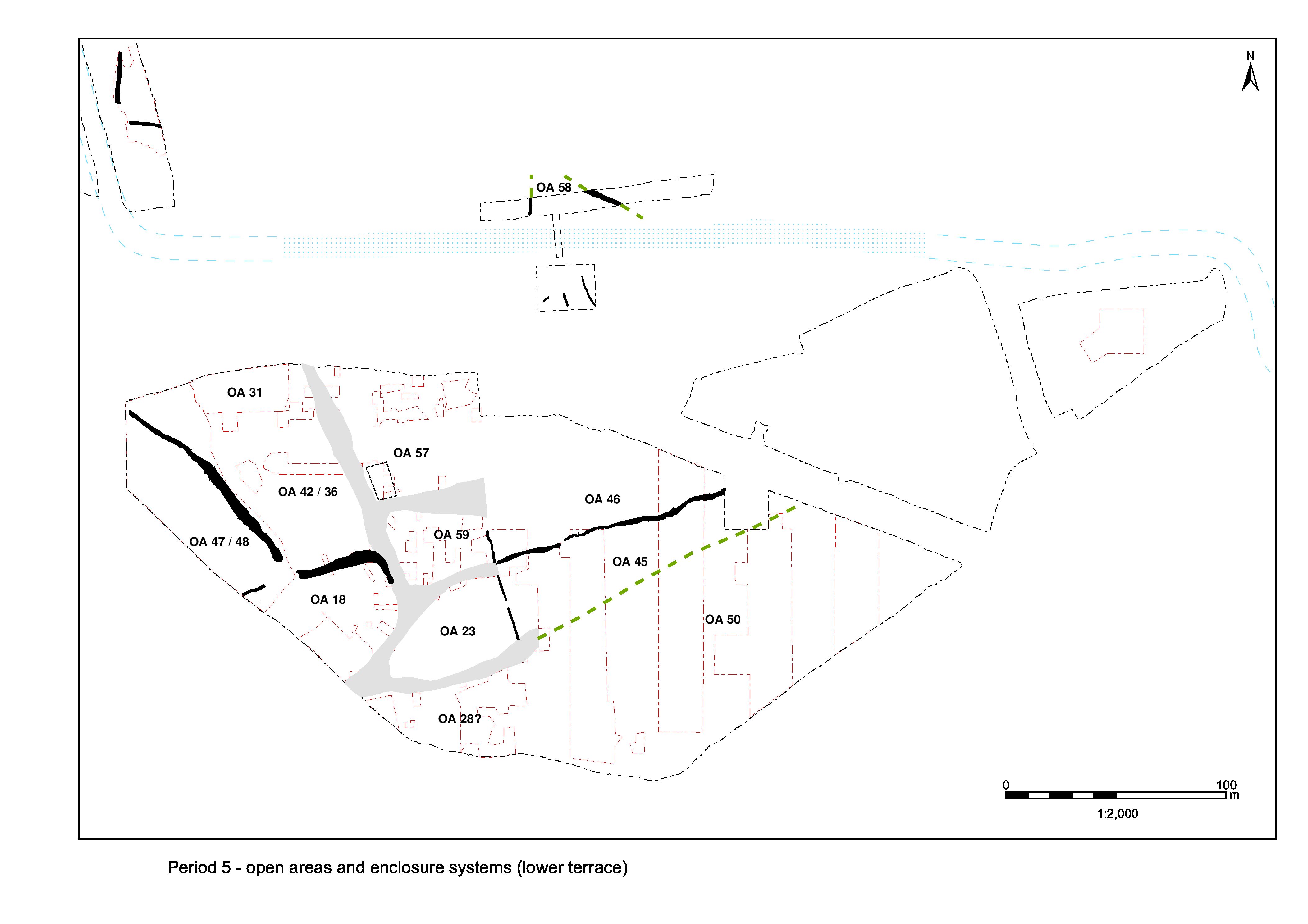
Its southern boundary continues to lie along the line of the former Road 3, to the south of which lies Open Area 50. In practical terms, there may be no real boundary between these two open areas and there is an argument for treating them as the same land-unit. However, the line of Road 3 may be perpetuated by a somewhat less formal thoroughfare such as a track or path. This said, Late Roman pits encroach upon Road 3. Their large and varied artefact assemblages are noted to be similar to those from pits in and around the temple precinct.
The construction of Building 59 on top of Road 4 confirms its abandonment. Together with apparent sub-enclosures that extend southwards from the building, across the interior of the eastern part of OA45, it may be inferred that this end of the enclosure loses its function as an open space and is now occupied. However, it is not possible to determine whether or not this new use continues to be related to the temple. In contrast, it is noted that the western end of OA45 clearly retains its close association with the temple and its rituals.
Building 59 is constructed across the line of former Road 4, probably during the 4th century, and thus demonstrates the disuse of this road by this time. Located tight alongside the northern boundary, the positioning of the building at the gap between ditches 25077 and 25262 (Group 466) would seem to be deliberate. It could be argued that ditch 25077 is offset northwards to avoid Building 59 and that the imposition of the boundary, at least at this point, post-dates the construction of the building.
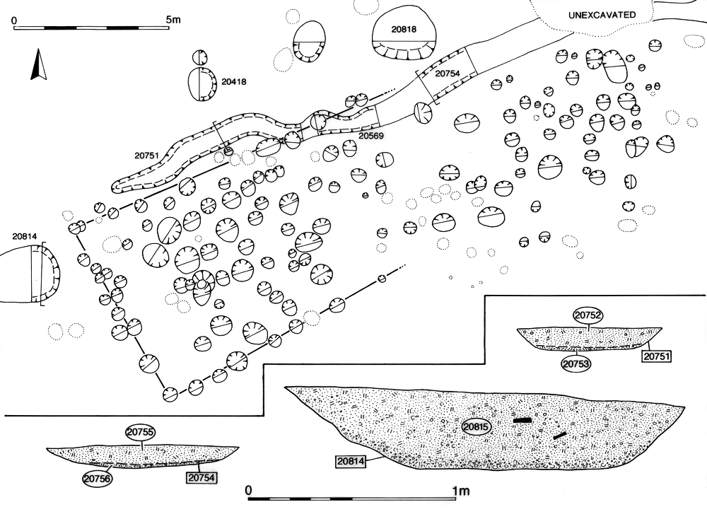
The evidence for Building 59 is derived from rectilinear alignments within a concentration of c. 140 post-holes cut into the gravel surfaces of Road 4 and OA45. The overall plan of a substantial building can be discerned from an arrangement of smaller post-holes (20382, 20384, 20386, 20408, 20464, 20470, 20479, 20620, 20626, 20628, 20648, 20650, 20654, 20656, 20677, 20685, 20695, 20697, 20700, 20702, 20704, 20727, 20891, 20895, 20897 Group 458), which form a 6.5m square, and a 3.7m by 4.7m rectangle of generally larger post-holes (20452, 20519, 20521, 20532, 20615, 20618, 20633, 20637, 20641, 20892 Group 459), set into the south-east corner of the outer square, which share the same southern wall (Figure 183).
Other elements of the building may, with less certainty, be represented by post-holes 20585, 20589, 20954 (Group 460) and 20571 (Group 461), which would extend the outer rectangle to a more symmetrical arrangement around the inner rectangle. However, this formulation of the building overlies ditch 25077 (Group 466). It is possible that only the inner rectangle, with its load-bearing posts, probably roof supports, form the building proper and that the slighter outer posts constitute a veranda or similar around it. However, as the inner room has an area of only c. 17m² (as opposed to c. 42m² for the entire structure), this interpretation would make the building quite small. A number of the constituent post-holes are inter-cut, perhaps denoting replacement of posts within the structure but, given the number of additional post-holes that fall within and around the building and cannot be readily incorporated into its plan, it is more likely that there was more than one phase of Late Roman structures at this location. Despite their small size, a surprisingly large number of the Building 59 post-holes contain small, but consistent, assemblages of Late Roman pottery, tile and tessera.
A number of thin, shallow, slots and post-holes are located to the south of Building 59. Further slight traces of slots were recorded on pre-excavation plans though not later found during excavation. However, in conjunction with the excavated evidence, these help establish that the slots are extensive and most likely associated with one another, though two phases are perhaps evident. All conform to the prevailing alignments of the wider settlement layout, either running ENE-WSW (Group 462) or NNW-SSE (Groups 463, 464).
Parallel with, and c. 7m south of, Building 59, slot 25076 (segs 20545, 20575, 20583) and integral post-holes 20498, 20576, 20577, 20581) describe a shallow ENE-WSW foundation traced for a distance of 8.5m. Post-hole 20396 may mark its westward continuation.
Less than 2m to the south, slot 25226 (seg. 20736) and small post-holes 20715, 20717 and 20721 may denote a similar foundation running parallel to it.
The NNW-SSE (and therefore perpendicular) alignments all lie to the south of 25076 and 25226. Slot 25156 (segs 20742, 20746) is located 8m to the south. Although only a 2m length is proven by excavation (including integral post-holes 20744 and 20748), pre-excavation planning suggests its original northward continuation - stopping just short of slot 25076. A similar, but wholly unexcavated slot runs parallel to 25156 and similarly stops short of 25226.
A 4m length of excavated slot 20928 also runs parallel to 25156, c. 9m to its south-west. With other unexcavated/unnumbered but similarly aligned slots evident on the pre-excavation plan west of this, it is perhaps reasonable to conjecture that the Late Roman subdivision of OA45 is extensive, even if relatively intangible.
Post-holes 20663, 20402, 20404 and 20406 (Group 464) form a tangible NNW-SSE alignment that may be a continuation of 25156 on the opposite side of slot 25076.
Crucial to the phasing of these features is that they share the same alignment as Building 59. They are interpreted as foundation cuts for fences dividing the interior of OA45. Some of the further miscellaneous excavated post-holes mentioned below may be part of this subdivision.
On the boundary between OAs 45 and 50, Late Roman pit 20193 (Group 718) is one of the largest at 2.7m diameter and 1m deep, and encroaches upon the former Road/track 3. This clay-lined pit contains a very large and varied assemblage of artefacts compared to the other pits of this date. Although only a modest quantity of pottery is present, personal items such as jet bracelet fragments (SFs 7491, 7494, 7495), a copper-alloy ring with intaglio (SF7486) and a bone hairpin (SF7493) are conspicuous. Accompanied by copper-alloy coins (SFs 7497, 8398), nails, cast waste and over 4kg of oyster shell, its artefact assemblage is perhaps reminiscent of pits in and around the temple precinct.
In the eastern part of Open Area 45, two inter-cut pits (15229, 15231 Group 699) of late 3rd to early 4th-century date again cut the gravels of former Road/track 3. Similar to pit 20193, both contained relatively prolific artefact assemblages. 15229 included twenty-eight iron hobnails, a spoon (SF6197), and a copper-alloy disc (SF5919), as well as a fragment of ceramic lamp and over 19kg of oyster shell. 15231 included a range of iron objects such as a cleat (SF6429), ferrule and reaping hook tang (both SF5928). Additionally, both contained a number of miscellaneous pieces of ironwork identified as nails, strip, block and plate fragments.
The lack of pits elsewhere across the OA45 interior may suggest that its occupying Building 59 and its associated structures are not of a domestic nature. However, it is equally possible that the nearby Late Roman pits in OA46 could represent associated disposal.
There are many post-holes in this part of the settlement (i.e. where investigated within Excavation Areas L and M - see also Groups 5010 to 5015). Some of these have been interpreted as defining Building 59. Another concentration of post-holes (Group 5014) lies directly to the east of Building 59 (NB: the group also includes outlying post-holes 20416 and 20853 in OA46 to the north of Building 59) and probably represents at least one further Late Roman building, the plan of which could not be discerned. Other post-holes in OA45 between the lines of former Roads 3 and 4 are almost certainly of Late Roman date (Groups 5013, 5015). An apparent scatter is evident in the middle of this area as well as a cluster on the former surface of Road/track 3 itself. However, features were not easily defined within the disturbed (and ?reworked) Period 2 gravel surface (20422 Group 177) into which they were cut. Further post-holes were almost certainly present within the areas of excavation. Furthermore, others parts of the gravelled interior of Open Area 45 were not subject to detailed investigation and the distribution of post-holes is strongly influenced by excavation constraints. In short, other structures and/or buildings of Late Roman date could conceivably be present elsewhere within Open Area 45.
Internet Archaeology is an open access journal based in the Department of Archaeology, University of York. Except where otherwise noted, content from this work may be used under the terms of the Creative Commons Attribution 3.0 (CC BY) Unported licence, which permits unrestricted use, distribution, and reproduction in any medium, provided that attribution to the author(s), the title of the work, the Internet Archaeology journal and the relevant URL/DOI are given.
Terms and Conditions | Legal Statements | Privacy Policy | Cookies Policy | Citing Internet Archaeology
Internet Archaeology content is preserved for the long term with the Archaeology Data Service (ROR). Help sustain and support open access publication by donating to our Open Access Archaeology Fund.