Cite this as: West, E., Christie, C., Moretti, D, Scholma-Mason, O. and Smith, A. 2024 A Route Well Travelled. The Archaeology of the A14 Huntingdon to Cambridge Road Improvement Scheme, Internet Archaeology 67 (Monograph 32). https://doi.org/10.11141/ia.67.22
The A14 landscape witnessed a rapid expansion in settlement activity during the Iron Age, marking a clear departure from the preceding pattern of low-visibility, low-density settlement. Iron Age settlements were recorded in all Landscape Blocks, with a wide range of settlement forms represented (Fig. 3.1; Table 3.1). Early Iron Age (800-350 BC) activity was, however, far more limited, comprising dispersed evidence with settlement only identified at Fenstanton Gravels and Conington. This is in marked contrast to the middle Iron Age (350-100 BC) which saw a notable peak in settlement numbers, alongside widespread changes in settlement form and agricultural strategies. Many of these showed evidence for multiple phases of development reflecting the changing roles or needs of the settlements. A high proportion of settlements seemingly did not persist much (or at all) into the late Iron Age (100 BC-AD 50), with the nuances of this presenting a complex pattern of settlement development (Fig. 3.2).
Use top bar to navigate between chapters
A total of 22 settlements were recorded, spanning the early to late Iron Age, displaying a variety of characteristics (Table 3.1). The range and diversity of settlements recorded throughout the Iron Age reflects the variety of agricultural activities taking place as well as wider societal changes. Past studies of Iron Age settlements have often focused on their classification into a range of categories, which at their broadest level comprised open and enclosed forms (Brudenell 2020; Knight 1984). However, the distinction between enclosed and unenclosed sites is often unclear and a focus on classification can come at the expense of understanding the less archaeologically visible aspects of settlement organisation and connection. As emphasised in recent studies the sheer diversity of settlement forms tends to defy typological approaches to settlement (Dawson 2000a, 109; Clay 2002; Evans et al. 2008; Wright et al. 2009; Medlycott 2011; Huisman 2019; Knight and Brudenell 2020). Consequently, settlement organisation across the A14 has been considered at a broader landscape scale, with a focus on highlighting hubs of activity, ideas of interconnectivity and wider landscape management.
At the western extent of the scheme, two settlements were identified at Alconbury (A1 and 2) spanning the middle to later Iron Age, while another (A4) had probable late Iron Age foundations, but was mostly Roman in date and is discussed in Chapter 4. Further to the south-east, the landscape extending from Alconbury to the River Great Ouse comprising Brampton West, Brampton South and West of Ouse, provides a key focus for Iron Age settlement development, with a total of nine settlements recorded. At Brampton West five settlements of varying form were revealed (BW 1, 2, 100, 102 and 202) with a further two recorded at Brampton South (BS 1 and 2) to the east. The two settlements identified at West of Ouse (WOO1 and 2) represent more dispersed activity extending towards the river. To the east of the river, two settlements were identified at River Great Ouse (RGO1 and 2), although one of these (RGO2) was heavily truncated by the establishment of a significant Roman settlement and a late Roman villa (see Chapter 4). Within the Fenstanton Gravels Landscape Block four settlements were recorded (FG1-4) and are probably contemporary with the single settlement identified at Conington (C3), and those recorded at the Dairy Crest and Cambridge Road sites just to the north at Fenstanton (Ingham 2022; Fig. 3.3). At the eastern end of the scheme at Bar Hill four settlements were recorded (BH1, 3-5), comprising a diverse range of settlement types, which are in turn linked to a wider area of settlement excavated to the north and east of Bar Hill at Northstowe and Longstanton (Evans and Dickens 2002; Evans and Mackay 2004; Evans et al. 2005; Patten and Evans 2005; Knight and Mackay 2007; Aldred and Collins forthcoming; Fig. 3.3).
This chapter opens with an examination of the development of settlements from the early to late Iron Age, exploring key themes and patterns as well as providing commentary on the available chronological data. This is followed by a consideration of the nature of settlement organisation and the various activities taking place within the sites, through a critique of the evidence for settlements, structures, and landscapes, as well as the varied socio-economic and ritual activities associated with the period. Importantly, the extensive and wide-ranging excavations undertaken across the A14 not only afford the opportunity to examine the settlements themselves but also to consider their relationship with their wider agricultural hinterlands and neighbouring settlements. While a number of these sites are discussed in brief, the broader networks across the A14 landscape are more fully considered in the wider synthesis of the Iron Age presented in the landscape monograph (Billington and Brudenell forthcoming).
Despite the relative abundance of evidence for Iron Age settlement across the A14, gaining a nuanced understanding of settlement development is hampered by several issues around the dating and phasing of features. This is a widely acknowledged problem within Iron Age studies relating to the difficulties in distinguishing chronologically diagnostic finds and ceramics (Hamilton et al. 2015; Percival 2024i), compounded by the often limited resolution provided by radiocarbon dating owing to the Hallstatt plateau (800-400 BC). A total of 55 samples were successfully radiocarbon dated from Iron Age features, with the resulting dates clustering from 380-100 cal BC (Table 3.2). The pottery assemblages often provided limited chronological resolution owing to the longevity of techniques and styles, with the notable exception of Aylesford-Swarling wares. These were in use from c. 100 BC and were characterised by a range of wheel-made tall urn-shaped vessels with pedestaled bases, a range of grooved and cordoned bowls, butt beakers and lid-seated jars (Percival 2024i; Fig. 3.4).
| Landscape Block | Group | Context | Sample | Material Dated | Labcode | δ13C relative to VPDB | Radiocarbon Age BP | Radiocarbon Date (95.4% Probability) |
|---|---|---|---|---|---|---|---|---|
| Alconbury | Ditch 5.116 | 50367 | 50367 | Animal Bone: cattle | SUERC-91495 (GU53776) | -21.7 | 2205±24 | 370-170 cal BC |
| Alconbury | Pit Group 5.290 | 51876 | 51876 | Animal Bone: cattle | SUERC-92680 (GU54234) | -22.3 | 2145±24 | 360-50 cal BC |
| Alconbury | Ditch 5.159 | 53850 | 53850 | Animal Bone: horse | SUERC-92681 (GU54235) | -21.8 | 2168±24 | 360-100 cal BC |
| Alconbury | Ditch 5.33 | 58027 | 58027 | Animal Bone: cattle | SUERC-92682 (GU54236) | -22.1 | 2174±24 | 360-120 cal BC |
| Alconbury | Roundhouse 5.63 | 51883 | 51883 | Animal Bone: cattle | SUERC-92683 (GU54237) | -21.7 | 2127±24 | 350-50 cal BC |
| Alconbury | Ditch 5.1 | 58047 | 58047 | Animal Bone: cattle | SUERC-92684 (GU54238) | -21.7 | 2275±21 | 400-210 cal BC |
| Brampton West | Ditch 7.319 | 738154 | 73831 | Charred Cereal grains: Triticum spelta | SUERC-91054 (GU53684) | -22.8 | 1961±24 | 40 cal BC - cal AD 130 |
| Brampton West | Pit Group 10.230 | 107101 | 10638 | Charred Cereal grains: Triticum sp. | SUERC-91143 (GU53696) | -21.2 | 2235±22 | 390 -200 cal BC |
| Brampton West | Structure 7.8 | 731462 | 731462 | Animal Bone: sheep/goat | SUERC-91465 (GU53753) | -22.1 | 2006±23 | 50 cal BC - cal AD 80 |
| Brampton West | Pit Group 7.7 | 730848 | 730848 | Animal Bone: sheep/goat | SUERC-91466 (GU53754) | -21.8 | 2161±24 | 360 -100 cal BC |
| Brampton West | Roundhouse 7.311 | 736570 | 736570 | Animal Bone: sheep/goat | SUERC-91476 (GU53762) | -21.8 | 2057±26 | 160 cal BC - cal AD 20 |
| Brampton West | Ditch 7.44 | 733386 | 733386 | Animal Bone: cattle | SUERC-91482 (GU53766) | -21.8 | 2019±26 | 100 cal BC - cal AD 70 |
| Brampton West | Ditch 10.257 | 103160 | 103160 | Animal Bone: sheep/goat | SUERC-91496 (GU53777) | -21.8 | 2022±23 | 90 cal BC - cal AD 70 |
| Brampton West | Pit 103162 | 103163 | 103163 | Animal bone: sheep/goat | SUERC-91502 (GU53781) | -21.4 | 2056±23 | 160 cal BC - cal AD 20 |
| Brampton West | Ditch 10.334 | 105123 | 105123 | Animal Bone: sheep/goat | SUERC-92686 (GU54241) | -21.5 | 1998±24 | 50 cal BC - cal AD 110 |
| Brampton West | Mound 10.167 | 600719 | 600719 | Animal Bone: cattle | SUERC-92691 (GU54243) | -21.3 | 1954±24 | 40 cal BC - cal AD 130 |
| Brampton West | Mound 10.167 | 601495 | 601495 | Animal Bone: horse | SUERC-92694 (GU54247) | -22.4 | 2128±24 | 350-50 cal BC |
| Brampton West | Mound 10.167 | 601512 | 601512 | Animal Bone: cattle | SUERC-92695 (GU54248) | -22 | 2101±24 | 200-40 cal BC |
| Brampton West | Mound 10.167 | 601030 | 601030 | Animal Bone: cattle | SUERC-92696 (GU54249) | -22.4 | 2101±24 | 200-40 cal BC |
| Brampton West | Pit Cluster 10.585 | 103999 | 103999 | Animal Bone: cattle | SUERC-92700 (GU54250) | -22.2 | 2032±21 | 100 cal BC - cal AD 60 |
| Brampton West | Inhumation Burial 7.3 | 720506 | - | Human bone: - | SUERC-97729 (GU57414) | -20.2 | 2154±25 | 360-50 cal BC |
| Brampton West | Inhumation Burial 7.151 | 731503 | - | Human bone: - | SUERC-97731 (GU57416) | -20.8 | 2138±25 | 350-50 cal BC |
| Brampton West | Inhumation Burial 7.664 | 767007 | - | Human bone: - | BETA-637561 | -19.1 | 2040±30 | 150 cal BC-cal AD 60 |
| Brampton West | Cremation Burial 10.62 | 604182 | - | Human bone: - | SUERC-97737 (GU57419) | -25.8 | 1976±25 | 40 cal BC - cal AD 120 |
| Brampton West | Ditch 7.6 | 730976 | 7340 | Charcoal: cf. Ilex aquifolium | SUERC-98094 (GU57464) | 26.1 | 2040±28 | 150 cal BC - cal AD 60 |
| Brampton West | Ditch 7.219 | 386094 | 38589 | Charred Cereal grains: Hordeum vulgare | SUERC-91385 (GU53720) | 2095±25 | 180-40 cal BC | |
| Brampton South | Pit Cluster 13.48 | 132325 | 13255 | Charred Cereal grains: Hordeum sp. | SUERC-91456 (GU53709) | -24.8 | 2199±24 | 370-170 cal BC |
| Fenstanton Gravels | Post-hole | 271057 | 27024 | Waterlogged wood: | SUERC-75284 (GU45479) | 2505±34 | 790-510 cal BC | |
| Fenstanton Gravels | Waterhole 29.2 | 290030 | F29087 | Waterlogged wood: | SUERC-75285 (GU45480) | 2441±34 | 760-400 cal BC | |
| Fenstanton Gravels | Waterhole 29.3 | 290586 | F29034 | Waterlogged wood: Birch | SUERC-75286 (GU45481) | 2369±34 | 720-380 cal BC | |
| Fenstanton Gravels | Pit | 270968 | 27063 | Burnt animal bone: | SUERC-75288 (GU45483) | 2507±34 | 790-510 cal BC | |
| Fenstanton Gravels | Inhumation Burial 28.610 | 281064 | - | Human bone: Tibia | SUERC-85552 (GU50640) | 2247±24 | 390-200 cal BC | |
| Fenstanton Gravels | Inhumation Burial 28.432 | 281210 | - | Human bone: Human- L Femur | SUERC-85553 (GU50641) | 2246±24 | 390-200 cal BC | |
| Fenstanton Gravels | Cremation Burial 28.538 | 285607 | 28654 | Human bone: - | SUERC-85558 (GU50643) | 2145±24 | 360-50 cal BC | |
| Fenstanton Gravels | Structure 28.489 | 281055 | 28220 | Charcoal: Pomoideae sp. | SUERC-91386 (GU53721) | 2264±25 | 400-200 cal BC | |
| Fenstanton Gravels | Ditch 28.63 | 790016 | 79003 | Charcoal: Ilex aquifolium | SUERC-91391 (GU53723) | 2048±25 | 160 cal BC - cal AD 30 | |
| Fenstanton Gravels | Roundhouse 28.134 | 281649 | 28252 | Charcoal: Pomoideae sp. | SUERC-91392 (GU53725) | 2309±25 | 410-230 cal BC | |
| Fenstanton Gravels | Cremation Burial 31.75 | 310135 | 31006 | Cremated Human Bone: - | SUERC-92291 (GU54160) | -21.2 | 2033±30 | 150 cal BC - cal AD 70 cal |
| Fenstanton Gravels | Ditch 28.340 | 780823 | 780823 | Animal Bone: sheep/goat | SUERC-92376 (GU54186) | -21.9 | 2176±28 | 370-110 cal BC |
| Fenstanton Gravels | Roundhouse 31.40 | 311127 | 311128 | Animal Bone: horse | SUERC-92381 (GU54190) | 2219±28 | 390-190 cal BC | |
| Fenstanton Gravels | Inhumation Burial 28.574 | 280801 | 280801 | Human Bone: - | SUERC-92755 (GU54646) | -20.2 | 2033±24 | 110 cal BC - cal AD 70 |
| Fenstanton Gravels | Pit Group 29.68 | 290571 | 29120 | Cereal grain: Hordeum vulgare | SUERC-98084 (GU57457) | -23.5 | 2386±28 | 720-390 cal BC |
| Fenstanton Gravels | Roundhouse 29.10 | 290850 | - | Animal bone- calcaneum: cattle | SUERC-98149 (GU 57559) | -22.3 | 2173±28 | 360-100 cal BC |
| Conington | Waterhole-Well 33.140 | 331827 | - | Wood: Oak | SUERC-92742 (GU54435) | -26.2 | 2281±17 | 400-230 cal BC |
| Bar Hill | Ditch 38.219 | 386094 | 38589 | Charred Cereal grains: Hordeum vulgare | SUERC-91385 (GU53720) | - | 2095±25 | 180-40 cal BC |
| Bar Hill | Ditch 41.81 | 410767 | 41056 | Charred root: non-oak | SUERC-91394 (GU53727) | - | 2285±25 | 410-210 cal BC |
| Bar Hill | Ditch 41.8 | 410094 | 41016 | Charred Cereal grains: Triticum sp. | SUERC-91395 (GU53728) | - | 1930±25 | cal AD 20-210 |
| Bar Hill | Ditch 38.83 | 384818 | 384818 | Animal bone: sheep | SUERC-91504 (GU53783) | - | 2179±26 | 370-150 cal BC |
| Bar Hill | Ditch 38.176 | 381772 | 381772 | Animal bone: sheep | SUERC-91505 (GU53784) | - | 2050±26 | 160 cal BC - cal AD 30 |
| Bar Hill | Inhumation Burial 38.74 | 381833 | 381833 | Human Bone: - | SUERC-91608 (GU53840) | - | 2178±26 | 370-120 cal BC |
| Bar Hill | Inhumation Burial (381956) | 381956 | 381956 | Human Bone: - | BETA-63492 | 2050±26 | 160 cal BC - cal AD 30 | |
| Bar Hill | Inhumation Burial 38.135 | 383075 | 383075 | Human Bone: - | SUERC-91609 (GU53841) | - | 2089±26 | 180-1 cal BC |
| Bar Hill | Ditch 41.2 | 410057 | 410057 | Animal Bone: cattle | SUERC-92371 (GU54177) | -21.7 | 2034±28 | 150 cal BC - cal AD 70 |
| Bar Hill | Pit 383971 | 383973 | 38535 | Wood: Oak | SUERC-92743 (GU54436) | -25.4 | 2259±21 | 400-200 cal BC |
| Bar Hill | Inhumation Burial 38.318 | 380391 | - | Human bone: - | SUERC-97751 (GU57438) | -20.1 | 2032±25 | 110 cal BC - cal AD 70 |
The presence or absence of Aylesford-Swarling wares provides a useful reference point for identifying the transition into the late Iron Age. Unlike the local traditions of hand-built pottery, including Scored Ware and East Midlands ware, Aylesford-Swarling wares tend to have a fairly tight date range (c. 100 BC- AD 70), contrasting with broad ranges appended to other local traditions (typically 350-50 BC) (Elsdon 1992; Percival 2024i). Two caveats though need to be attached to this general hypothesis; the first being that hand-built wares persist into the later Iron Age and beyond, secondly the presence or absence of these objects could reflect social rather than temporal factors. Indeed, the relative conservativeness of Iron Age pottery can be partly attributed to its largely utilitarian role in the Iron Age, with changes in form occurring in the 1st century BC being keyed into wider social changes (Pitts 2005; Sutton et al. 2024). These vessels are often associated with broader changes in material culture and society, notably the development of a distinct range of funerary practices, and a general uptake in the use of brooches (Mackreth 2011), and coinage (see Cunliffe 2005 for overview). With these caveats in mind the presence or absence of Aylesford-Swarling wares does nonetheless provide a useful yardstick by which to gauge the relative chronology of the various Iron Age sites, alongside other artefacts and the suite of radiocarbon dates.
In the following section, the broad chronology and key features of the recorded settlements are outlined. This discussion opens with a consideration of the nature of the evidence for settlement during the early Iron Age before examining the expansion of settlements that took place in the 4th century BC. The final section considers the evidence for settlement aggregation and contraction during the late Iron Age. Detailed stratigraphic descriptions and discussions by phase can be found within the individual Landscape Block reports. While this section touches on aspects of the early to mid-1st century AD, the transition into the Roman period is considered more fully in Chapter 4.
The transition from the Bronze Age into the Iron Age is typically seen as involving the advent of new materials, societal transformation, and the intensification of agriculture (Haselgrove and Pope 2007). The period also witnessed significant environmental changes, with the development of an increasingly open environment with rising water levels from c. 800 BC (French and Heathcote 2003, 85; Evans et al. 2016). Iron Age settlements of this period typically, like their Bronze Age counterparts, are characterised by low visibility remains, hampering identification (Haselgrove et al. 2001; Haselgrove and Pope 2007). Where recorded, early Iron Age settlements across Cambridgeshire typically comprise small-scale 'open' settlements, containing a repertoire of pits, post-holes, wells and four-poster structures, such as at Milton landfill and Park and Ride sites, Cambridge (Y. Phillips 2015), Trumpington (Patten 2012) and Clay Farm Cambridge (Phillips and Mortimer 2012). While the denser 'pit cluster settlements' as typified by Trumpington are generally restricted to southern Cambridgeshire on the chalk (Evans et al. 2018, 119), there is mounting evidence (e.g. Cambridge Road, Ingham 2022) for the presence of smaller scale settlements extending to the west, which appear to be associated with seasonal activities.
The nature of the early Iron Age activity from the A14 fits within this pattern, taking the form of disparate features, comprising pits, ditches, and possible structures, although only in two cases did these define settlements (Table 3.1 XLSX). At the western end of the scheme limited evidence for early Iron Age activity, in the form of pits containing early Iron Age pottery, was recorded at Brampton West. However, more substantial early Iron Age activity was recorded at Thrapston Road located c. 0.5km to the north-east of Brampton West. Early Iron Age features, including large groups of post-holes defining four- to six-post structures and a post-built roundhouse, were recorded spread across an area measuring c. 200 × 200m (4 hectares; Reid and Atkins 2019). The layout of the features at Thrapston Road is comparable to the two early Iron Age settlements recorded within the central section of the A14 at Fenstanton Gravels and Conington.
The settlement at Conington 3 comprised a dispersed collection of pits, small ditches, waterholes, and a possible structure. These features were located within and around a Bronze Age field system, possibly suggesting a deliberate referencing or reoccupation of the feature, although the precise chronology and relationship of the settlement and field system is uncertain (Fig. 3.5). The two large waterholes provided evidence of the local environment, with an abundance of seeds indicative of nutrient-enriched, cultivated ground (Fosberry 2024; Wallace and Ewens 2024). The features at Conington 3 potentially represent occupation scatter or peripheral activity associated with seasonal, sporadic or short-lived agricultural activity as opposed to permanent settlement (Brudenell 2021; White et al. 2024).

In contrast,the early Iron Age features at Fenstanton Gravels, located c. 1.2km to the north-west, indicate a greater concentration of activity and transformation of the site. At Fenstanton Gravels 2 early Iron Age settlement was concentrated at the eastern extent of the Landscape Block (TEA 29), comprising a possible roundhouse, pits, structures, waterholes and a droveway/field ditches extending north (Fig. 3.6). The roundhouse, roundhouse 29.10, was located adjacent to the droveway/field ditches, which extend for over 200m with 13 four-post structures located at its northern extent. The presence of over a dozen four-poster structures probably represent the remains of raised granaries or drying platforms, associated with the cultivation of wheat (Triticum spp.) and barley (Hordeum vulgare), as evidenced by the environmental remains (Hunter Dowse and Turner 2024). Barley appears to have been the main crop grown during this period, contrasting with the middle to late Iron Age, when wheat became the predominant crop. Surrounding the structures was a group of six waterholes from which a rich artefactual assemblage was recovered including a notable collection of waterlogged wood. This included the remains of an alder plank screen or fence, two ladders (F29087 and F29117), a piece of twisted withy rope (F29060), a Y-crotch section of birch (F29034) and an oak stirring paddle (F29109) (Fig. 3.7). Ladder F29087 was radiocarbon dated to 760-400 cal BC (SUERC-75285) with the Y-crotch section of birch dated to 720-380 cal BC (SUERC-75286), overlapping with the final Bronze Age notched log ladders found at Striplands Farm to the west (Patten and Evans 2005; Evans et al. 2011) (Fig. 3.7). Also of note is the presence of an iron spud (F29023) from the fill of waterhole 29.2; these tools are typically associated with agricultural activities (Humphreys and Marshall 2024b). The environmental assemblages and pollen analysis indicate the presence of damp grassland, with the waterholes representing pastoral activity and the management of livestock. The presence of dwarf pond snails is indicative of wet grassland or the margins of a water body subject to occasional flooding.

To the east of Fenstanton Gravels 2, further early Iron Age activity was recorded at TEA 27 consisting of a four-poster structure and eight pits, one of which contained a nationally important Iron Age poker-shovel (F27020 and F27021) , associated with metalworking (Fig. 3.8). The industrial waste from the site comprised a small assemblage (756g) of smithing hearth cakes, suggesting small-scale iron smithing during the early Iron Age. Further pits with early Iron Age pottery were noted at TEA 28, but these appear to be unrelated to activity at Fenstanton Gravels 2, located on the east side of contemporary gravel streams. At Albion Archaeology's Cambridge Road, Fenstanton, excavations to the north of the A14's Conington and Fenstanton Gravels Landscape Blocks, a sequence of intercutting pits, a trackway, a single four-post structure and up to four cremation burials were dated to the early Iron Age (Ingham 2022, 16; Fig. 3.3). Further settlement evidence has been identified at Church Farm, Fenstanton, with a late Bronze Age/early Iron Age circular enclosure, a linear droveway, a possible hearth and several pits (Carlyle and Chapman 2002; ECB2070), while an extensive spread of cropmarks to the north of Conington suggest further settlement activity (MCB11492), although the precise dating of these is unclear.
Overall, it is clear, as is typical for most of the region, that the earliest Iron Age of the A14 is characterised by low visibility, unenclosed settlements. The ephemeral nature of most of these could be indicative of seasonal patterns of occupation and use of fertile grasslands for stock grazing reflecting a persistence of earlier settlement patterns (see Chapter 2). The high number of four-poster structures at Fenstanton Gravels 2 may indicate a shift towards more permanent forms of occupation, pre-empting the wider expansion of settlement in the middle Iron Age. This mix of seasonal and more permanent settlement is observed across the Cambridgeshire region, with larger aggregate 'pit settlements' being noted, such as at Trumpington Meadows where in excess of 750 pits were recorded (Patten 2012; Evans et al. 2018, 126). These more intensive 'pit settlements' are typically not found on the clay uplands to the north and west of Cambridge, partly reflecting prevailing geological conditions (Evans et al. 2018, 119). The potential permanence of settlement at Fenstanton Gravels 2 could be related to the expansion of arable cultivation within this part of the A14, partly motivated by the suitability of the local soils. These settlements at Fenstanton Gravels and Conington are located within areas of high fertility or free-draining soils, with the settlement at Fenstanton Gravels 2 being located within a large band of high fertility soils suited to arable cultivation (Fig. 3.9). A similar pattern is noted at Thrapston Road (Reid and Atkins 2019) and at Striplands Farm, suggesting that the location of sites may have been informed by a degree of local knowledge about underlying ground conditions (Patten and Evans 2005; Evans et al. 2011, 42). From the 4th century BC onwards a wider range of soils were quickly brought under cultivation, giving rise to a dramatic and unprecedented increase in the number of recorded settlements.

The middle Iron Age witnessed a 'settlement boom' with settlements identified at all A14 Landscape Blocks, coinciding with a rapid expansion into the region's clay uplands (Evans et al. 2008, 179, 193). This is a pattern witnessed across much of lowland Britain, with a dramatic shift in the visibility and number of recorded settlements (Sherlock 2012; Heslop 2020; Brudenell 2021; Willis 2022). On the A14, this expansion appears to be reflected in the environmental data, which shows an overall reduction in woodland in the middle-late Iron Age (Grant 2024a-h). Woodland decline during this period is often linked to the expansion of agricultural activity onto poorer soils and settlement into previously marginal areas (Grant et al. 2011). Pin-pointing the commencement of settlement in the middle Iron Age on the A14 presents a challenge but also an opportunity to test the seeming lack of continuity from the early Iron Age. Archaeologically, the majority of settlements across the A14 appear to begin in the middle Iron Age from c. 350 BC, with a total of 17 settlements established during this period (Table 3.1, Figs 3.2 and 3.10). Numerous settlements displayed evidence for development throughout the middle Iron Age as enclosures were defined, remodelled and areas of domestic activity established. The duration of activity and variable patterns of decline reveal insights into the complexities of this process of 'colonisation', the mechanics of which will be more closely examined in the final section of this chapter.

At the north-western end of the scheme two settlements were recorded at the southern end of the Alconbury Landscape Block, bounded by the Ellington Brook to the south, which appears to have partly influenced the layout of the settlements (Fig. 3.11). This close positioning of the settlement on a stream or river is echoed at several other sites across the A14, including at Brampton West 1, and within the wider region including at Scotland Farm, Dry Drayton (Callow Brook; Abrams and Ingham 2008) and Loves Farm, St Neots (Fox Brook; Hinman and Zant 2018; Abrams and Ingham 2008). There was no evidence of early Iron Age (800-400 BC) activity at Alconbury, with the ceramic assemblage and the small number of radiocarbon dates from Alconbury 1 supporting a middle Iron Age date from the 4th to 1st centuries BC (Table 3.1; Rebisz-Niziolek and Hudak 2024a; Percival 2024i). Alconbury 1 appeared to develop around 350 BC and comprised an extensive boundary ditch with a co-axial field system and enclosures orientated along its length. As indicated by the cropmark data it is probable that this boundary continues as Linear Boundary 2, which formed the spine of Alconbury 2, serving to connect these two settlements (Fig. 3.11). The cropmark data also indicate the presence of a series of enclosures at the southern end of the U-shaped boundary, although the relationship of these to the boundary is uncertain.

Alconbury 2, based on its relationship to Linear Boundary 2, was established at a slightly later date than Alconbury 1 and potentially outlived it. As at Alconbury 1, the majority of the settlement activity took place to the west of the area delimited by the boundary, with the earliest phases comprising a series of conjoined enclosures and roundhouses. One structure, roundhouse 5.63, had a complete vessel placed upside down into a centrally located pit, suggestive of a 'closure' deposit (see Placed deposits). The second phase of Alconbury 2 was defined by a rectilinear enclosure system established over much of the middle Iron Age settlement. The small number of radiocarbon dates and the presence of sherds from La Tène style decorated vessels tentatively suggest activity extending into the 1st century BC but provide little clarity as to the date of transition. The overall dating of this field system is uncertain but does appear to suggest a shift in the location of the settlement focus. This could have been towards the north, where evidence for 1st century AD occupation was noted at Alconbury 4, although only a small area of this settlement was uncovered (see Chapter 4). The 'abandonment' of this area could reflect continued issues with seasonal flooding, which also appeared to occur at Brampton West 1, c. 1km to the south.

The middle Iron Age activity at Brampton West extended for over 1km, comprising four defined settlement areas. Brampton West 1 was the northernmost of the Brampton West settlements, being established around the 4th century BC, just to the north of a large palaeochannel. This channel formed part of a wider network of channels located across the flat land at the base of the slope (Fig. 3.12). The presence of these channels undoubtedly influenced the location of the Iron Age settlements within this block. The middle Iron Age phase of Brampton West 1 comprised a dense network of at least four enclosures with scattered boundaries extending across the area (Fig. 3.12). The enclosures, like those at Alconbury 2, appear to have been employed for a mix of domestic occupation and as stock enclosures, with the area to the east perhaps employed as pasture or arable fields (explored in more detail in the following sections). It is possible that these were also located to the south of the palaeochannels extending towards Brampton West 100.

A more constrained range of features was recorded at Brampton West 100, comprising a north-east to south-west aligned boundary ditch and a pair of enclosures 0.175km to the east of these ditches (Fig. 3.13). A single inhumation burial (7A.3), dated to 360-50 cal BC (SUERC-97729; Table 3.2), was located in the south-western corner of the Landscape Block, and is one of a number of articulated middle Iron Age burials recorded from across the scheme (see 'The dead'). The ceramic assemblage from an isolated pit (720642) included two small vessels, deposited broken but carefully arranged alongside a complete saddle quern potentially reflecting a deliberate deposit (as explored in 'Placed deposits') (Fig. 3.14). The vessels were large versions of slack-shouldered jars with characteristics suggestive of an early or middle Iron Age date c. 600-200 BC (Sutton and Rebisz-Niziolek 2024). While the assemblage from a single isolated pit does not definitively date the commencement of the settlement it does raise the potential for earlier activity preceding the main phase of settlement.
Contrasting with the relative dearth of features at Brampton West 100, Brampton West 102 just to the south comprised an extensive series of ditches, trackways, roundhouses, and enclosures (Fig. 3.13). These were broadly concentrated in the north-western and south-eastern parts of the settlement, defining separate settlement foci. Beyond these areas there was a range of scattered pits and various ditches, as well as a probable cemetery (Cemetery 102) forming part of the wider spread of activity associated with the settlement. Taken collectively, the ceramic assemblage, which included middle Iron Age East Midlands Scored Ware and East Anglian Plainware, may indicate a commencement of occupation prior to the introduction of Aylesford-Swarling wares in the 1st century BC (Sutton and Rebisz-Niziolek 2024).
Brampton West 202 was located at the southern extent of the Landscape Block and along with the initial phases of Brampton West 100 could represent the earliest Iron Age settlement within the block. The settlement covered an area of c. 5ha comprising a field system, enclosures and possible structures (Fig. 3.15). The pottery assemblage was dominated by hand-built pottery of East Midlands Scored Ware/East Anglian Plainware Type, suggesting activity during the 3rd to 1st centuries BC prior to the large-scale adoption of Aylesford-Swarling pottery (Sutton and Rebisz-Niziolek 2024). Unlike the other Brampton West settlements, there was no evidence for continuation into the 1st century BC. The activity at Brampton West 202 is probably contemporary and linked to the two middle Iron Age settlements uncovered at Brampton South located 200m to the east.


Activity at Brampton South comprised two discrete areas of settlement, although as at Alconbury 2 it is probable these were contemporary and interconnected settlements (Fig. 3.16). The earliest phase of the southernmost settlement, Brampton South 2, was based around Linear Boundary 3, which respected the late Bronze Age-early Iron Age pit alignment. To the north of the boundary was an enclosure system and a series of roundhouses lay to the south (Fig. 3.17). The final phase comprised the setting out of a rectilinear field system, echoing the phases of development at Brampton South 1, 0.27km to the north-west. At Brampton South 1 the earliest phases of the settlement comprised a pair of parallel ditches on a north-north-east to south-south-west alignment, possibly the remnants of a trackway (Fig. 3.16). The precise dating of this feature is uncertain, but both ditches appear to fall out of use around the same time, being succeeded by a new settlement focus to the south. As at Brampton South 2, the settlement was arranged on a north-west to south-east alignment. The settlement focus to the north of the linear boundary comprised a series of wells and waterholes alongside several roundhouses and ditches, which in its third phase were succeeded by a pair of enclosures. It is possible that during the middle Iron Age there was a contraction in settlement activity with the focus of domestic activity being located within Brampton South 2, as indicated by the higher quantities of pottery. The precise chronology of this change is unclear, but the absence of later artefact types, notably wheel-thrown pottery, suggests the settlement did not extend into the 1st century BC.
The final phase of activity at Brampton South was marked by the setting out of a field system just to the north, which continued to respect the alignment of the earlier settlement phases. Taken as a whole, the evidence from the Brampton West and South Landscape Blocks suggests a fairly extensive, albeit dispersed, pattern of settlement, characterised by linear boundaries and enclosure systems, with areas of pasture or arable fields between. At a broad level these settlements appear to be contemporary although it is apparent that within this there are subtle shifts in patterns of occupation, with some areas, such as at Brampton South, seeing a possible contraction in activity. The probable end date of the settlements at Brampton South overlaps with the expansion of the settlements at Brampton West to the north and may suggest a shift of settlement to the north.
During the middle Iron Age only very limited activity was identified at West of Ouse, 0.39km to the south-east, comprising dispersed ditches, an enclosure, pits and post-holes (see Fig. 3.24). It is possible that this area acted as a transitional zone between the settlements at Brampton West and the River Great Ouse. The activity at West of Ouse can also been seen as part of a north to south aligned zone of activity, extending south along the valley of the River Great Ouse, with Buckden and Offord Cluny 0.5km to the south and a further cluster of Iron Age activity around Little Paxton Quarry (Jones 2000; Fig. 3.3). In essence the sites at both West of Ouse and River Great Ouse can be seen as forming a 'T-junction', with what was probably a key routeway through the landscape (Chapter 2). The middle Iron Age activity at River Great Ouse 2 was defined by extensive linear boundaries with adjoining enclosures (Enclosure 4 & 5; Fig. 3.10). Enclosure 4 defined an area 125m² with a 5.5m wide entranceway to the north-east. Two possible roundhouses were identified within the enclosure with middle Iron Age pottery, fired clay and animal bone recovered from the enclosure ditch. Enclosure 4 adjoined a boundary ditch, which was recorded on a north-west to south-east alignment for c. 0.5km. A further boundary ditch extended to the east and appeared to link Enclosure 4 to Enclosure 5. The ditches within Enclosure 5 seem to define paddocks or stock enclosures potentially functioning as a central point or gathering place, with the multiple boundaries directing movement towards the enclosure. Middle Iron Age activity at River Great Ouse extended to the east, with a roundhouse, enclosures and scattered pits identified at River Great Ouse 1. The majority of the pottery assemblage is handmade dating from c. 350-50BC, with no evidence for wheel-made ware or transitional pottery (Percival and Lyons 2024). It is possible that the absence of late Iron Age activity could, as at Brampton South, reflect a contraction of settlement, or potentially a process of settlement drift, with activity lying beyond the A14 corridor.

Turning to the central section of the scheme, settlement remains were recorded at Fenstanton Gravels and Conington. As highlighted previously these sites are notable for their early Iron Age settlements, contrasting with the low levels of activity recorded elsewhere along the A14. During the middle Iron Age there was a significant expansion in activity, with four settlements recorded at Fenstanton Gravels and one at Conington (Table 3.1; Fig. 3.2). Further middle to late Iron Age activity was also recorded to the north at Dairy Crest and Cambridge Road, Fenstanton (Ingham 2022; Fig. 3.3). The middle Iron Age phase of Fenstanton Gravels 2 was centred on a single enclosure and a field system that partly overlay the early Iron Age features, suggesting a degree of continuity between the two phases (Fig. 3.18). Within the enclosure were the remains of two roundhouses, suggesting a small domestic compound. To the west of Fenstanton Gravels 2 new settlements were established at Fenstanton Gravels 4 and 3, during the 4th century BC. Fenstanton Gravels 2, unlike these 'later' settlements, did not persist into the late Iron Age, likely ending around the 3rd or 2nd century BC, suggesting that the focus of settlement shifted to the west, to Fenstanton Gravels 4, where at least two phases of middle Iron Age settlement were recorded (Fig. 3.18). Both settlement areas, spaced 200m apart, comprised unenclosed features, with the south-western being the most extensive. Associated with the settlement was a single roundhouse, which contained large quantities of pottery and evidence of structured deposition (see 'Placed deposits'). The dating of this deposit, as with most of the Fenstanton Gravels features, is biased towards pottery, predominantly comprising examples of Scored Ware. The radiocarbon dating of inhumation burial 28.432 returned a date of 390-200 cal BC (SUERC-85552), while one of the two unurned cremation burials in Cemetery 5, located at the north of the site, was dated to 350-50 cal BC (SUERC-85558; Table 3.2). It is possible that this burial dates to the later Iron Age phases of the site, as this period saw a general uptake in cremation burials across the region (see 'Burial patterns'). This pattern of dispersed settlement persisted into the second phase of activity, which saw the setting out of two C-shaped enclosure ditches and a field system, bounded at its western edge by a palaeochannel, which was probably open into the Roman period.
Fenstanton Gravels 3, located just to the west of the channel, comprised further dispersed settlement features, although the overall character of the settlement is unclear as it was largely unexcavated. Geophysical survey to the north showed extensive settlement remains, although the date of these is uncertain, while cropmark data showed an extensive system of rectilinear enclosures broadly aligned onto the palaeochannel, extending to the north-east (Cox 2014; Jones and Panes 2014). Given the high quantity of Roman remains the possibility of these being Roman cannot be ruled out (see Chapter 4).
The enclosures at Fenstanton Gravels 1, 1.5km to the east of Fenstanton Gravels 4, comprised at least two phases of settlement, both of which were located just to the north of a curving palaeochannel (Fig. 3.18). The first phase comprised a rectilinear field system and a single roundhouse. In its second phase, this field system was replaced with a small compound, comprising a rectilinear enclosure divided into two, with a single roundhouse in each cell. Again, as seen at other sites, this suggests changes in the nature of settlement and activity within this area, which could reflect wider changes in patterns of pastoral and agricultural farming (as discussed in the following section). The enclosure was further extended during the middle Iron Age with the addition of a second enclosure, associated with two roundhouses. The roundhouses to the west of this second enclosure appear to have remained in use, suggesting this 'extension' could reflect the presence of a growing population. The hand-built ceramic assemblage comprised wares again indicative of a middle Iron Age date (Banks and Perrin 2024). The ceramic assemblage from Fenstanton Gravels 1 contained no wheel-made wares, with comparative analysis suggesting it may not have continued beyond the end of the 1st century BC. Settlement at this time may have become focused around Fenstanton Gravels 3 and 4. To the north and east are several cropmarks suggestive of further field systems or enclosures, and within the eastern cluster of cropmarks were a number of small enclosures and trackways. It is unclear if these are contemporary with the Iron Age phases of Conington 3, located just to the east of Fenstanton Gravels 1 (Fig. 3.19). Several of the recorded cropmarks align with the later Roman roadside settlement, which at its peak may have extended across much of the area to the north of Conington and Fenstanton Gravels (see Chapter 4).

Contrasting with Fenstanton Gravels 2, the middle Iron Age phases of Conington 3 did not closely correspond with the earlier Iron Age settlement, suggesting either a degree of discontinuity or a replanning of the settlement (Fig. 3.19). The middle Iron Age settlement took the form of a linear boundary and a sequence of conjoined enclosures on a roughly north-east to south-west alignment, corresponding with several of the previously identified cropmarks. Enclosure 11 was formed of two rectangular sub-enclosures with a possible north-facing timber entranceway identified to the western sub-enclosure. Immediately adjacent, a series of curvilinear ditches defined Enclosure 12. The finds and pottery distributions suggest that Enclosure 12 may have formed the focus of activity, with a comparatively high density of pottery, metalworking debris and possible midden material recovered. The ceramic assemblage from Conington 3 included wares indicative of the middle Iron Age (c. 350-100 BC) with the single radiocarbon date from Well 33.140 returning a date of 400-230 cal BC (SUERC-92742; Table 3.2).
At the south-western extent of the scheme, four middle Iron Age settlements were recorded at Bar Hill, with activity spanning the 4th century BC to 1st century AD. While no direct evidence for late Bronze Age to early Iron Age activity was recorded, two loom-weight fragments were believed to be of this date (F38420 and F38730) . Late Bronze Age to early Iron Age activity was documented at Striplands Farm just to the east, with further activity to the north at Northstowe (Patten and Evans 2005; Evans et al. 2011; Aldred and Collins forthcoming; Fig. 3.3). The settlements at Bar Hill 1 and 4 represent relatively small-scale activity, with the latter probably being closely associated with the large complex enclosure system at Bar Hill 5. This system, centred on the double-ditched Enclosure 11, was probably established in the 2nd century BC and was associated with a second enclosure, Enclosure 14, which may have been used for corralling livestock (Fig. 3.20). These enclosures appeared to have succeeded an earlier phase of unenclosed settlement, echoing the pattern of development at Bar Hill 3, where a large sub-oval enclosure was established in the 2nd century BC, truncating an earlier enclosure and several unenclosed roundhouses (see Fig. 3.32). The shift towards enclosure at Bar Hill 3 and 5 likely reflects an increased emphasis on the definition of space and spatial organisation within settlements, a point that is further considered in the second half of this chapter.
The emergence of middle Iron Age settlements at Bar Hill forms part of a wider expansion of settlement across this area, with multiple Iron Age settlements recorded at Longstanton and Northstowe (Fig. 3.3). At the latter, middle Iron Age activity was recorded in three locations with around 27 individual settlements recorded over an area of 750 hectares, echoing the relatively dense occupation noted at Brampton West. While the precise date at which the Northstowe area was 'colonised' is unclear it was most likely broadly contemporary with that at Bar Hill, which ostensibly forms part of the same densely populated landscape. The middle Iron Age settlements at Northstowe, like those at the A14, comprised a diverse range of types, with an early phase of unenclosed activity that developed into a series of enclosed settlements (Aldred and Collins forthcoming). As at Brampton West, the relative density of settlement within this area suggests the emergence of independent but interconnected settlements, creating wider opportunities and tensions. These themes will be further examined in the final part of this chapter.
Taken as a whole the character of settlement during the middle Iron Age reflects one of rapid expansion, with new areas of settlement being established. The tempo and duration of these is uncertain, but in at least two cases they overlapped with early Iron Age settlements. Nevertheless, the absence of obvious early Iron Age precursors to most middle Iron Age settlements should not be taken as evidence that these were 'empty' spaces. As highlighted in the preceding chapter, the valleys and ridgeways of the Ouse were landscapes of movement or 'landscape communication corridors' (Evans et al. 2015). The presence of scatters of early Iron Age pottery and other finds across the A14 is suggestive of low visibility activity, perhaps connected to seasonal movements, across the corridor. This forms a notable point of continuity with the Neolithic and Bronze Age, whose scattered monuments dot the valley (see Chapter 2). This activity could represent a long drawn out 'pioneering' phase in which populations were actively engaged with the landscapes across the valley. The chief change in the middle Iron Age lies in the increased visibility of the period, created by the establishment of suites of enclosures, trackways and boundaries. These boundaries could be fairly extensive and may reflect the increased definition of territories during the period (Lambrick and Robinson 2009, 80-8). At Brampton South 2, the Iron Age boundary appeared to respect the earlier late Bronze Age-early Iron Age pit alignment, suggesting potential continuity of boundaries over time (see Chapter 2 for discussion of pit alignments). In many cases the settlements recorded across the A14 saw multiple phases of expansion/contraction and changes in function. This shift towards 'permanence' was to continue into the later Iron Age, which saw several settlements seemingly decline while others reached their zenith in the late 2nd to 1st century BC. It is to these changes that the next section will turn, sketching out the key developments and nature of the later Iron Age settlements.
The development of settlements into the late Iron Age presents a complex pattern of abandonment, reduction and expansion. A total of 13 settlements established and developed in the middle Iron Age were 'abandoned' by c. 50 BC. As will be further outlined, this apparent pattern of decline masks a series of complex processes, which saw activity focused within particular landscape locales (Fig. 3.21). These include a particular focus around Brampton West, which saw notable expansion and development in this period. This may have extended to Alconbury, although it is also possible that this settlement was more aligned with further Iron Age activity to the north, including a dense cluster of geophysical anomalies to the north of Alconbury 1 and 2. Owing to this ambiguity, Alconbury is considered as its own 'unit'. Within the central section there is a clear coalescing of settlement around the Fenstanton Gravels and Conington Landscape Blocks, extending north to the Dairy Crest and Cambridge Road sites at Fenstanton, as well as incorporating a dense array of cropmarks. To the east a third foci developed around Bar Hill, which extended further to the north with the nascent settlements at Northstowe and Longstanton. The character and development of each of these blocks is further considered in the next section.

Before examining the expansion and development of the late Iron Age settlements at Brampton West, it is worth considering the development and position of its neighbour at Alconbury, located c. 1km to the north. Only a limited number of late Iron Age features were documented at Alconbury 2, comprising a series of recuts to parts of the enclosures, likely reflecting continued efforts at water management before its abandonment. While no direct evidence for late Iron Age occupation was noted, there was, as attested by the geophysical survey, evidence for dense settlement to the north of Alconbury 2 (in the area of Alconbury 4; see Chapter 4), while the recovery of later Iron Age pottery, including Aylesford-Swarling types, at Weybridge Farm (MCB1048) just to the east of Alconbury 2, hints at further settlement. The degree to which this settlement was aligned to the south with Brampton West is unclear, and it is possible that the Ellington Brook marked the boundary between the two zones; in the absence of additional data it is difficult to comment further.

In contrast to the limited evidence from Alconbury, Brampton West saw extensive development in the later Iron Age. The proliferation of settlement across Brampton West represents the development of individual settlements established in the middle Iron Age but also an increased sense of connectivity with numerous trackways and linear boundaries crossing the area (Fig. 3.21). Activity becomes centred around Brampton West 1, 2, 100 and 102 with Brampton West 202 having fallen out of use, along with the settlements at Brampton South. Activity at Brampton West 1 in the 1st century BC saw the expansion and development of the middle Iron Age enclosure system, with the addition of further enclosures, linear boundaries and field systems extending over c. 0.12km (Fig. 3.22). The radiocarbon dates, finds and ceramic assemblage obtained from later features indicate activity extending into the 1st century AD with the enclosures falling out of use at the very end of the Iron Age. Both enclosures were truncated by two ditches extending from the palaeochannel and probably reflect continued efforts at water management. Radiocarbon dating of a sample from Ditch 7BC.44 returned a date of 100 cal BC-cal AD 70 (SUERC-91482; Table 3.2) indicating it may have been a final (or very early Roman) attempt to make use of the area. Contemporary with this continued settlement, a new settlement was established at Brampton West 2, located immediately to the west of Brampton West 1. Brampton West 2 comprised a domestic focus of activity within an area defined by two parallel boundaries and small plots (Fig. 3.22). The pottery assemblage, like that at Brampton West 1, was dominated by Aylesford-Swarling wares with a minor inclusion of Roman wares potentially extending activity to c. AD 40-60/70 (see Chapter 4). To the south, Brampton West 100 also expanded in the late Iron Age, with the establishment of a series of enclosures, small post-built structures, and ditches (Fig. 3.21). Again, the pottery assemblage comprised Aylesford-Swarling wares, supplemented by limited quantities of hand-built East Midlands Scored Ware and East Anglian Plainware, with the inclusion of early Roman pottery indicating activity persisted into the later 1st century AD, when the site was again extensively redeveloped (see Chapter 4). The activity at both Brampton West 1 and 2 was probably also contemporary with the redevelopment and expansion of the Iron Age settlement at Thrapston Road, Brampton (Reid and Atkins 2019). Here the earlier Iron Age activity was superseded by an enclosed settlement to the east. During the later Iron Age a series of substantial sub-square and sub-rectangular enclosures were created, echoing the patterns of development noted at Brampton West.

The most extensive redveloped transformation was at Brampton West where a series of enclosures, trackways, and linear boundaries were established, representing an intensification of activity and a formalisation of the settlement (Fig. 3.23). The settlement continued to maintain the north-west to south-east alignment established in the middle Iron Age, suggesting a degree of fossilisation in land rights and/or boundaries. The activity was concentrated in two areas connected by a series of trackways, with a small cremation cemetery (Cemetery 102) and three pottery kilns located to the south-east (Fig. 3.23). These form part of a wider group of early kilns recorded across Cambridgeshire, reflecting changes in pottery technology alongside the introduction of new pottery forms (see Sutton et al. 2024). The majority of this activity was located close to the connecting spine ditch, which probably served to define the limits of settlement as well as the wider agricultural hinterlands associated with the settlement. At the northern end was a pair of enclosures, which were connected to a series of trackways. These underwent numerous modifications over time, potentially reflecting wider changes in the location of the associated fields. Both enclosure ditches contained quantities of Aylesford-Swarling wares, which comprised the bulk of the late Iron Age ceramic assemblage from Brampton West 102. When considered alongside the radiocarbon dates and other finds it indicates that the late Iron Age phase of Brampton West 102 probably spanned the 1st century BC to 1st century AD, representing an intensive phase of activity.
To the south-east, the impression of West of Ouse as a transitional landscape to this more concentrated activity continues, with late Iron Age activity confined to dispersed pits across the eastern areas of the Landscape Block (TEA15 and 16; Fig. 3.24). The ceramic assemblage from West of Ouse 2 was distinct from that of the earlier activity, being dominated by wheel-made wares dated to the first centuries BC and AD (Sutton and Hudak 2024a). On the eastern side of the river, at River Great Ouse 2, only a limited number of features could be directly dated to the late Iron Age including a stone trackway, ditches, pits, post-holes and a waterhole, though it is likely that many middle Iron Age features remained in use (Fig. 3.24). The rare cobbled routeway has few parallels but an example at Brigstock, Northamptonshire, was interpreted to date from the 2nd to 1st century BC (Jackson 1983). A metalled surface was also noted at Bar Hill 3, forming part of the enclosure entrance and could represent efforts at ground consolidation in light of increasingly waterlogged conditions. Possibly both West of Ouse and River Great Ouse were occupied seasonally, forming part of the wider hinterland of Brampton West, with the River Great Ouse and its floodplain defining the eastern limit of this settlement agglomeration. The use of rivers as territorial boundaries is widely noted with several sites within the Thames Valley showing signs of modification or incorporation into settlement boundaries (Lambrick and Robinson 2009, 62). In the A14 landscape, this association appears to extend to the deliberate positioning of settlements close to water. The partitioning of space also emerges as a key theme at Brampton West during the later Iron Age, with its northernmost settlement nestled within the bend of a palaeochannel and its central area defined by a sequence of linear boundaries and trackways. This highly organised landscape contrasts with the more dispersed nature of the later Iron Age settlement within the central section of the A14 at Fenstanton Gravels and Conington.
By the late Iron Age, Fenstanton Gravels 2 appears to have fallen out of use. Instead Fenstanton Gravels 4 appeared to form the primary focus of occupation during the period, with at least three areas of occupation recorded towards the southern edge of the settlement. These were associated with a series of enclosures, field systems, as well as a south-east to north-west aligned trackway. (Fig. 3.25). Just to the east of the north-western end of the trackway was a single banjo enclosure, which could have been used for the corralling of livestock. Fenstanton Gravels 4 displayed evidence for expansion and development into and throughout the Roman period (see Chapter 4), providing evidence for the continued importance of specific locations. Further Iron Age features were recorded at Fenstanton Gravels 3 to the north-west, comprising a limited number of ditches and enclosures, while at Fenstanton Gravels 1 elements of the middle Iron Age enclosure system remained in use, being partially redefined through the addition of several further ditches. Of particular note is the increase in the number of roundhouses associated with the enclosures, although it is unclear if these are contemporary with each other or reflect multiple episodes of occupation.

At Conington 3, the settlement appears to have persisted into the late Iron Age in a much-reduced form. The middle Iron Age enclosures appear to have been abandoned before the second half of the 1st century BC, with the focus of activity shifting to the north-east. Within this area the remains included a series of small ditches and gullies forming part of a field system, a small post-built structure, a group of pits, and the southern terminus of a large boundary ditch. Occupation seems to have ceased by approximately 50 BC.
Unlike the settlement features excavated at Brampton West, those at Fenstanton Gravels and Conington are seemingly marked by a lack of physical interconnectivity, comprising a range of features dispersed across the landscape. This could reflect the limitations of the excavation, and it is possible that further elements of Fenstanton Gravels 4 lie to the south of the limit of excavation, while as noted in the case of Conington the existence of a suite of cropmarks extending north of the A14 is indicative of further settlement. The form of at least one area of the cropmarks in plan is suggestive of Iron Age enclosures similar to Brampton West (Fig. 3.23). In addition, further Iron Age remains were recorded at Dairy Crest and Cambridge Road, Fenstanton, although the precise phasing of these is at present uncertain (Ingham 2022). The development of settlement within this area finds parallel within the Bar Hill block, where distinct settlement foci were identified, not only within Bar Hill itself, but also just to the north at Northstowe.
During the early 1st century BC there are marked changes in the size and layout of the enclosures at Bar Hill 3 and 5, suggestive of increased spatial division within the settlements. The large sub-oval enclosure at Bar Hill 3 saw a reduction in the size of the enclosed space, though with the addition of an annexe defining a small area for the penning of livestock (see Fig. 3.32). The reduced interior space appears to have formed the focus for domestic occupation, with the space being further divided by a series of smaller enclosures in the southern half. While appearing to suggest a decline or contraction in the scale of activity, it is probable that this reflects changes in the way that space was organised and managed, with a clearer split between occupation and non-occupation areas being established.

This process is also noted at Bar Hill 5 during the 1st century BC, although here the definition of space appears to be less clear (Fig. 3.26). The earlier large double-ditched enclosure (Enclosure 11) appears to have largely fallen out of use, although it seems to have been partially recut across its northern edge. The 'final' use of the enclosure is marked by the placement of an infant burial (381956) dated to 160 cal BC-cal AD 30 (Beta-63492; Table 3.2). Associated with the infant remains were a perforated dog tooth amulet (F38189) , while two late Iron Age coins (F38190 and F38192) from the same context, although not directly associated with the burial, could represent further grave goods (Scholma-Mason 2024). The coins comprised a 'Bury Diadem' and a 'Broadoak Boars' type, from Essex, both of which are traditionally dated to the late 1st century BC, although close dating of Iron Age coins is often problematic, drawing largely on known historical events (Haselgrove 2019, 243; see discussions in Bowsher 2024f; Marshall and Humphreys 2024). The remainder of the settlement is characterised by a complex sequence of intercutting enclosure ditches, with activity generally being centred around Enclosures 9 and 15. As at the other A14 sites an assemblage of Aylesford-Swarling wares was recovered along with several 1st century BC brooches. Among the latter were examples of Nauheim and Drahtfibel types (Marshall and Humphreys 2024). While the precise chronology of this enclosure sequence is uncertain, it does suggest sustained, albeit potentially reduced, activity throughout the 1st century BC, overlapping with activity at Northstowe. Unlike Bar Hill 3, which had largely been abandoned by the Roman period, Bar Hill 5 saw extensive redevelopment, with the setting out of a new system of enclosures (see Chapter 4). The layout of both settlements appears to reflect a concern with the management of livestock, a point reinforced through analysis of the faunal data from the sites.
The contemporary settlements at Northstowe, just to the north of Bar Hill 5, also underwent changes during this period, with - as at Brampton West - several of the earlier sites undergoing processes of consolidation and expansion. Within this scheme the settlement at Bar Hill 5 could have formed part of the wider agricultural hinterland of the Northstowe 'centres', echoing the consolidation of activity to the west at Brampton West.
The apparent decline in settlement abandonment and aggregation of settlements in the late Iron Age was influenced by a multitude of social and environmental factors. The final phases of Alconbury 1 and 2 were characterised by the replacement of the enclosures with a small field system, suggesting domestic occupation had shifted elsewhere. In the case of Brampton West 1 and Alconbury, the abandonment of the sites at the beginning of the late Iron Age appears to have been prompted by increasingly waterlogged conditions. This process, while having its origins in the late Bronze Age, persisted into the late Iron Age and may have led to the abandonment of many low-lying sites in favour of new settlements on higher ground (Abrams and Ingham 2008, 29).
This apparent decline in settlement was not universal across the A14, with several sites showing signs of expansion or aggregation, incorporating aspects of enclosed, linear and open settlements. The pattern at Brampton West perfectly demonstrates the difficulties in ascertaining changing settlement patterns. The excavations at Brampton South and Alconbury are moderate in scale and if considered in isolation may be interpreted as indicating decline. However, when considered alongside the evidence from Brampton West, the picture that emerges is one of settlement aggregation, with settlement being focused within a number of key areas. This process can be seen across the A14, including the aggregation of settlement around Bar Hill and Northstowe. Alongside this there is increased evidence for interconnectivity and zoning of activities. This includes the increasing use of enclosures to define areas of settlements, and within these further subdivisions, marking out zones of activities. The process of enclosure could reflect settlement status as well as facilitating water management, as the environmental evidence suggests many of the ditches contained standing water, which could have been utilised as water sources for livestock, offsetting the need for wells or waterholes within the enclosures, at least at certain times of the year. The specific function and utilisation of these spaces is more fully considered in the following section.
The Iron Age of the A14 is characterised by a strikingly diverse range of settlement forms developing from the middle to late Iron Age against a backdrop of changing environmental conditions, social structures, agrarian economies and material culture. What emerges from the framework outlined above is the apparent concentration of settlement features within particular landscape locations. The majority of the Iron Age settlements across the A14 are often located within areas that afforded access to a diverse range of resources, extending from rich pasture to a range of dryland and wetland resources, the latter of which would have been subject to seasonal flooding. The proliferation of boundaries and enclosures during this period, potentially reflecting changes in agricultural practices, tenure, community and connectivity, results in the greater visibility of middle-late Iron Age settlement across a range of landscape settings.
To examine these points further, aspects of settlement organisation and economy will now be explored, starting with an exploration of the middle Iron Age settlements at Alconbury, before turning to the three main foci of settlement that developed in the middle Iron Age and persisted into the later Iron Age. This review examines these aspects across the middle to late Iron Age, eschewing the earlier split into middle and late in order to develop a longer-term perspective of changing settlement function.
To the north of the Ellington Brook, the organisation and development of the settlements is closely tied to the local landscape and environment. The settlements at Alconbury were connected through a curving linear boundary, with activity at Alconbury 1 probably defining the earliest part of the middle Iron Age settlement, and Alconbury 2 reflecting a slightly later expansion or development. The development of Alconbury 2 saw an increased focus on enclosure but appeared to retain the alignment of the earlier linear boundaries, which served to define a broadly U-shaped 'internal' area (Fig. 3.27). As previously outlined, our understanding of this area is reliant on the cropmark data which suggest the presence of internal divisions and trackways. The space between Alconbury 1 and 2, measuring at least 14ha, may represent a space used for overwintering cattle, but could, like the annexe at Bar Hill 3, have been used for a range of seasonal activities. The partitioning of the inner space into two would have allowed for the separation and sorting of livestock, with further divisions being created using movable hurdles or screens.

The area to the south-east beyond the boundary could represent summer pasture and, as suggested by the environmental evidence, perhaps also as managed floodplain hay meadows (Wallace and Ewens 2024; Fig. 3.27). During the spring the vegetation across this area would be allowed to grow before being cut in midsummer as a hay crop. In summer, the cut area would be used as grazing for animals, preventing taller coarser species from becoming dominant. This system created food for cattle not only during the summer but also in winter, when the high-nutrient hay could have been employed as fodder. This need for fodder may have been influenced by a focus on dairy cattle, as indicated by the culling of very young animals and the presence of older animals. Alongside this there was also evidence for a focus on meat products (Cussans 2024; Wallace and Ewens 2024). The area beyond the western edge of the settlement could have been used as arable land or formed part of the wider pastoral landscape, potentially being used for grazing cattle prior to their summer transfer to the floodplain meadows, or for keeping sheep, which generally have wider grazing patterns. The boundary could have fulfilled a range of roles, including protecting crops from grazing livestock, as well as an aid to funnelling animals into the interior of the enclosure, which could have been further helped by the use of dogs, of which there was at least one example at Alconbury 2 (Cussans 2024).
Turning from the 'empty spaces' to the function of the enclosures at Alconbury 2, there is an apparent focus of activity within Enclosure 3 with an antler comb associated with textile working, which could have been the primary drive for rearing sheep on site (Wallace and Ewens 2024). While kiln furniture was recovered from a series of large pits within the enclosure it is unclear if these are intrusive from the Roman reuse of the site (Machin 2024a). There was limited evidence for cereal cultivation or processing; this may have taken place at low intensity within small garden plots or to the west within the open fields, with the focus of the site appearing to be animal husbandry. The presence of scarabaeoid dung beetles in the Enclosure 3 ditch and in Waterhole 5.70 with Enclosure 2 suggest that some livestock may also have been kept within these areas (Allison 2024a). The analysis of Iron Age wetland settlements, such as at Black Loch of Myrton (south-west Scotland), Flag Fen and Glastonbury Lake Village, point towards temporary stalling of animals and periods of animal-human cohabitation (Mackay et al. 2020). The more spatially constrained enclosures at Alconbury, which appear to include areas of domestic occupation, may have allowed livestock to be kept in close proximity for rearing, breeding and care.
The final phase of Alconbury 2 indicates a dramatic shift in activity with the development of Field System 2, which formed land parcels attached to a late phase of occupation. By this point the settlement may have been more open, reflecting changing agricultural practice and settlement organisation, with no evidence for domestic activity into the late Iron Age. The patterns observed at Alconbury provide a template through which we can explore the wider landscape, highlighting the potential zoning of activities and the importance of natural features such as palaeochannels for settlement arrangement. The proposed arrangement of activities at Alconbury risks being branded as 'environmentally deterministic' but the organisation of settlements was intrinsically linked to a variety of factors both social and environmental.
The middle to late Iron Age phases of settlement at Brampton West represent one of the densest concentrations of features within the A14 corridor. The contemporary activity at Thrapston Road, Brampton, to the north-east could represent further elements of wider settlement landscape associated with Brampton West. As highlighted previously, two distinct phases can be defined, with the settlement initially developing during the middle Iron Age and reaching its apogee in the late Iron Age. The growth and development of settlement across the landscapes is stimulated by a range of factors, including an apparent expansion in agriculture as evidenced by the increase in the range of enclosures and trackways associated with all the settlements. Importantly, as at Northstowe and Bar Hill, these settlements are closely interrelated, independent yet interconnected. The nature of these connections can be observed through a consideration of the development of the settlements over time and the changing functions being undertaken. Owing to the scale of the data from Brampton West, as well as its importance for illustrating a number of key themes of the period, this section firstly considers aspects of agriculture and settlement function, exploring the relationship between features and arable/pastoral strategies on site. The second part considers the nature of domestic occupation and of several smaller scale 'industries' at Brampton West.
From the outset the middle Iron Age settlements of Brampton West had a clear focus on spatial divisions, employing a mixture of natural boundaries (rivers/streams) alongside created boundaries, as indicated by the presence of hedgerow taxa, which could have served to further divide fields or define enclosures. During the middle Iron Age, the settlement at Brampton West 1 could have functioned in a similar fashion to that at Alconbury 1 and 2, with its position next to the palaeochannel facilitating access to floodplain meadows as well as rich grazing areas, owing to the presence of free draining soils (Fig. 3.28). The waterlogged plant remains from the site indicated the presence of a high water-table, with grass and scrubland in the surrounding area (González Carretero 2024). This impression is further reinforced by the presence of several species of freshwater snails recovered from across the Landscape Block (Pipe 2024c).
As at Alconbury 2, it is probable that livestock at Brampton West 1 were moved across this landscape throughout the year, with a series of trackways appearing to extend to the palaeochannel, facilitating the movement of livestock to these meadows, while during the other months of the year livestock were moved into wider areas of pasture. The faunal data indicates that livestock during this period principally comprised caprines, with other domesticates being comparatively scarce. Sheep were kept with a focus on meat, although it is also possible that a range of secondary products were also exploited. The apparent absence of lambs suggests that these were kept elsewhere. Cattle were present but in relatively small numbers. Given the general preference of sheep for drier and wider areas of pasture it is possible the cattle were kept within the floodplain meadow, with sheep being kept in the larger areas of pasture to the south. Isotopic analysis of sheep bone suggests that these tended to graze across wider areas with more canopy cover or closer to the freshwater peat-fens than the cattle (Moore et al. 2022; Wallace and Ewens 2024).

The area to the south of Brampton West 1 was largely devoid of features, except for those associated with Brampton West 100 at the eastern end of the TEA (Fig. 3.29). As at Alconbury 2, these 'empty spaces' could represent key elements of the agricultural landscape, defining potential areas of arable cultivation or grazing, which may have been shared by the settlements at Brampton 1 and Brampton 102. While the middle Iron Age phases of Brampton West 102 are partly obscured by the extensive development of the site in the late Iron Age, there is a clear sense of a complex and divided landscape, with two cores of activity at the northern and southern end of the Landscape Block, with open areas of field and pasture between them. Curiously, these sites appear to exist on the same alignment as those at Brampton South, suggesting a potential persistence of earlier prehistoric routeways or alignments. Alternatively, the axis of these sites could have been influenced by local topography, with the sites generally occupying an area of ground at the base of a slight ridge (Fig. 3.29). This positioning also appeared to reflect the boundary between an area of free-draining soil and heavy lime-rich soil. As at Alconbury 2, it is likely this placement was informed by an awareness of local ground conditions. The positioning of the site within this area would have facilitated access not only to rich grazing land in drier upland areas but also fertile soils, which extended to the south. These patterns of movement appear to be partly reinforced through the orientation of the middle Iron Age trackways that cross this 'boundary', reinforcing the impression that livestock were being moved between different areas of pasture. This hypothesis could be extended to suggest that the previously discussed open spaces at the settlements were, like the interior of the space at Alconbury, used to overwinter cattle. Isotopic analysis of cattle remains from Brampton West does suggest potential seasonal shifts between grazing and foddering (Moore et al. 2022; Wallace and Ewens 2024). In this regard, access to and the management of floodplain meadows emerges as a key aspect of the agricultural regime, underscoring the importance of these resources at both Alconbury 2 and Brampton West 2. During the winter this pressure on food resources may have been offset through modest culling, a practice that is evidenced in the faunal assemblages across the A14 (Wallace and Ewens 2024). The use of extensive grazing areas would also have helped to alleviate these issues (Lambrick 1992), and this could account for the large number of 'empty spaces' at Brampton West, reflecting an extensive system of grazing and arable land.
The faunal remains from Brampton West 102 suggest a focus on cattle husbandry, contrasting with the sheep-dominated assemblage at Brampton West 1. While settlements likely practiced a range of economic activities, the patterns observed at Brampton West may indicate an emphasis on particular activities at specific locations. This could include the potential movement of cattle from Brampton West 1 to other areas for butchering. The limited butchery evidence at Brampton West 102 suggests a focus on marrow extraction. Marrow could have been extracted for consumption, representing a high nutrition resource. In at least one case a fragment of cattle bone had been sawn to form a flat spacer or inlay. Alongside a focus on meat there was evidence for cattle breeding on site and dairying. The evidence for dairying is further illustrated through isotopic analysis, which suggested that the Iron Age cattle birth season was spread over a prolonged period of 9 months, indicative of a dairying economy (Moore et al. 2022; Wallace and Ewens 2024).
The livestock regime appears to have been supplemented through the cultivation of a range of arable products. Within Brampton West 1 there was limited evidence for cereal processing in the form of a fragment of rotary quern of probable 'Beehive form' (F7232 ; Shaffrey and Banfield 2024). The archaeobotanical assemblage analysed from Brampton West 102 showed spelt wheat and barley were being cultivated (González Carretero 2024). Rare evidence of food preparation was recovered from Brampton West 102, with fragments of a bread or porridge-like food identified within Pit 105462 located at the western edge of the settlement (González Carretero 2023). The location of the fields associated with these crops is uncertain, but it is likely that some of the linear boundaries across the site served to separate these from the wider areas of grazing.
The impression of a mixed subsistence economy continues to the southern extent of Brampton West within Brampton West 202. The middle Iron Age phase of Brampton West 202 comprises features possibly associated with the management of livestock in the form of a large enclosure (Enclosure 201) with internal subdivisions, which could have been used for a variety of tasks. Most of the faunal remains were recovered from the fill of the enclosure, with cattle being predominant (NISP: 33). The settlements at Brampton South, as previously highlighted, form part of the wider pattern of activity at Brampton West, being located to the east of Brampton West 202. The environmental data from this settlement are more constrained but do support the idea of a mixed subsistence strategy.
In summary, the picture emerging from the archaeological remains and the environmental data is the development of a range of settlements practising a mixed subsistence strategy. Within this there are hints of differences among the settlements, notably between Brampton West 1 and Brampton West 102, where hints of an emphasis on specific activities can be observed. It is possible that this could reflect a degree of specialisation, with the proximity of the sites to each other allowing for this, a pattern that is also seen within the Bar Hill Landscape Block, and will be further considered in the final part of this chapter. The general arable and pastoral strategies established during the middle Iron Age persist into the late Iron Age, albeit with an increase in the scale of agriculture, partly reflected in the increased formalisation of the landscape.
During the late Iron Age there was an expansion and formalisation of the landscape, which included the development of a new enclosure system at Brampton West 2 on the hill slope west of Brampton West 1, which was itself reconfigured with new enclosures nestled into the inner meander of the palaeochannel; elsewhere there was the development of an array of enclosures, linear boundaries and trackways at Brampton West 102 (Fig. 3.30; West et al. 2024). The previously occupied areas at Brampton South 1 and 2 and Brampton West 202 appear to have fallen out of use, suggesting a consolidation of settlement around Brampton West 1/2 and Brampton West 102. Activity at Brampton West 1 shifted to the south and west, suggesting this relatively empty area during the middle Iron Age was further developed, forming a focus of domestic occupation, with Brampton West 2 probably forming part of the wider agricultural landscape associated with the settlement. Unlike the other settlements across the Brampton West Landscape Block, this settlement persisted into the Roman period (see Chapter 4).
The extensive enclosures at Brampton West 1 at the northern end of the Landscape Block saw an increased emphasis on the division of space with the enclosures containing several internal subdivisions. The development of enclosures continued to be heavily influenced by the palaeochannel, with them extending to the south and west of the central Enclosure 2. A significantly high mean density of animal bone was recovered from Enclosure 2 (5.67kg/m³) in contrast to the other enclosures, perhaps suggesting animal processing was taking place within the enclosure. The faunal remains show a continued emphasis on sheep/goat with cattle, horse and dog also present (Faine 2024b). Of note is the presence of at least six near-complete young animals within Structure 7BC.663, which did not show signs of butchery, and could represent the disposal of diseased animals. To the west of Enclosure 2, a series of small fields covering an area of at least 35m north-south by 40m east-west were uncovered. Within these fields were the remains of a curvilinear feature, 2.65m in diameter, which could represent the remains of a thatched hayrick with an eaves-drip gully. The fields were associated with the cultivation of spelt wheat (Triticum spelta), and hulled barley (Hordeum vulgare). While barley could have been grown for human consumption, it could also have, as in the Roman period, been grown for fodder (see Chapter 4). Analysis of recovered food remains (seven samples in total) from across the A14 showed that while barley was used in the production of leavened bread, wheat was the principal grain of choice (González Carretero 2024; 2023). Further west, and extending across the heavy lime-rich soil, was Brampton West 2, which appeared to represent a separate late Iron Age settlement, characterised by domestic occupation and quarrying, echoing the development of Brampton West 102 to the south with its focus on a range of activities.
This activity to the north at Brampton West 1 and 2 may be complementary to the significant settlement foci that developed along a north-west to south-east axis at Brampton West 102. During the late Iron Age there is a clear division of the settlement into three distinct areas; at the northern end a pair of enclosures associated with a wider series of trackways, a central area with a series of ring ditches, and a southern set of further enclosures (Fig. 3.30). These discrete areas were interlinked by a series of linear boundaries and trackways. Within the northern area the pair of enclosures (Enclosure 112 and 111) were likely closely associated with the management of livestock, acting as a hub through which livestock passed through before being moved into different parts of the landscape. These enclosures could have fulfilled a variety of roles, including the seasonal processing and separation of herds and the exchange of cattle and other resources between communities (Hamilton et al. 2019). More broadly, the enclosures may have been used as a defined gathering place for communities serving a range of functions both social and agricultural. Within this model it is tempting to suggest that the material evidence recovered from the fills of these features reflect seasonal gatherings rather than sustained occupation, which was instead located to the north and south of this area. These enclosures were connected to a sequence of trackways, with multiple phases of use and development, potentially reflecting key routeways or changes in the location of areas of grazing (Fig. 3.30). Throughout this there is an emphasis on east to west movement, from the heavy lime-rich soils of the 'uplands' to the enclosures on the lower lying areas at the foot of the ridge. The areas between these trackways could have been employed for overwintering livestock or for arable cultivation. Contrasting with the middle Iron Age there was a fairly even split between cattle (NISP: 550) and sheep and goat (NISP: 615). The focus of the pastoral regime appears to have been geared towards meat production, although secondary products such as milk and wool were likely exploited (Wallace and Ewens 2024). There is a notable shift at Brampton West 102 to a more mixed pastoral economy, with cattle and sheep being present in equal numbers. This non-specialised herding strategy is typical of the Iron Age (Albarella 2019, 102) and can be found among a range of sites across Cambridgeshire (Wallace and Ewens 2024). Pig, which forms a minor component of most of the A14 faunal assemblages, was also present in reasonable numbers (NISP: 139). Isotopic analysis of pig remains from across Brampton West suggest two distinct husbandry strategies, one where pigs were raised near to, and consuming, the same water sources as humans, and a second where pigs were grazed in a similar environment to cattle with potential canopy cover (Moore et al. 2022; Wallace and Ewens 2024). This could suggest grazing within the western half of the site, which closely borders the edge of Brampton Woods.
Arable cultivation showed a continued trend for mixed cultivation regimes with a range of crops being grown. Among the crops there was a high quantity of free-threshing wheat grain (Triticum aestivum), which differs considerably from the composition of the rest of the analysed palaeobotanical assemblages from the A14 as a whole. Free-threshing wheat, while found elsewhere, tends to represent a minor component and its presence in Iron Age contexts has often been explained through recourse to arguments of residuality. However, as argued by Wallace, the incidence of these remains at Brampton West 102, despite the scarcity of definitive chaff evidence, may reflect a genuine preference for free-threshing wheat, a trend that becomes more evident in the late Iron Age (Wallace and Ewens 2024). There is also, in contrast to the preceding period, an increase in the number of querns on site, suggesting a potential increase in crop processing (Shaffrey and Banfield 2024). While the data from Brampton West as a whole suggests an intensification and expansion of agriculture, the impression is still of an economy geared towards subsistence rather than surplus, a pattern that is also apparent in the various middle to late Iron Age crafts taking place across the block.
Alongside the agricultural focus there was evidence for a range of other small-scale activities across the Landscape Block. This included evidence for textile production, with a concentration of textile-related objects located around Enclosure 1 at Brampton West 1, while a long-handled comb (F60063) was recovered from Brampton West 102, alongside several loom weights. Evidence for metalworking was also recorded at Brampton West 1 and Brampton West 102. From the former, several smithing hearth bottoms were recovered, concentrated around roundhouse 7BC.311. As in the early Iron Age at Fenstanton Gravels, the scale of this metalworking reflects fairly short-lived episodes. At Brampton West 102 there was some evidence for non-ferrous metalworking, in the form of casting waste and a probable mould cast fragment. It is possible this metalworking was geared towards the production of tweezers and other small implements in the late Iron Age (Humphreys and Marshall 2024b; Marshall 2024e). Analysis of metalwork suggests a transition from a bronze-rich assemblage in the Iron Age towards a complex range of copper-alloys by the early Roman period (Moorhouse 2021, 44; see Chapter 4). Alongside the evidence for metalworking, seven late/terminal Iron Age pottery kilns were recorded across Brampton West 102. The majority of these comprised fairly short-lived and poorly defined features, hampering further identification. The clearest examples were Kiln 10.710 and Kiln 10.706 from which sherds of Aylesford-Swarling wares were recovered. A sherd showing signs of spalling, possibly resulting from a misfiring in a kiln, was identified from Kiln 10.706 although this is far from certain. Indeed, whether these kilns were directly involved in the production of Aylesford-Swarling, in the absence of wasters, remains an open question (Sutton et al. 2024).
Radiographic and petrographic analysis of Aylesford-Swarling pottery from the A14 suggests that coil building remained the predominant mode of production. Wheel-thrown vessels were comparatively rare, contrasting with neighbouring Hertfordshire, where wheel-thrown pottery is widely recorded (Sutton et al. 2024). This suggests that while Aylesford-Swarling wares were being adopted and produced, this was being undertaken within a particularly local context, creating subtle, invisible distinctions which were expressed through differences in technology. The degree to which this was undertaken by resident or peripatetic potters is unclear, but combined with the limited evidence for metalworking and other craft activities it does suggest that Brampton West formed a focus for a wide range of activities, extending beyond the day-to-day agricultural tasks, reinforcing the impression of the Brampton West settlements having a fairly distinct signature in comparison to the other A14 settlements.
Echoing the patterns observed at Brampton West, the evidence from specialist analyses of the finds and environmental data indicates variations in socio-economic status among the middle to late Iron Age settlements within the Fenstanton Gravels and Conington Landscape Blocks. In the following section these distinctions are further reviewed, drawing attention to the variations in agricultural regimes across this area. As previously outlined the settlement evidence is somewhat limited, constraining the level of analysis that can be undertaken when compared to Brampton West. The settlements appear to be more dispersed, with limited evidence of the dense agglomeration seen at Brampton West, although cropmark data to the north of Conington does suggest the presence of further enclosures. As highlighted previously the settlements at Fenstanton and Conington were, in contrast to the majority of the other Iron Age settlements, located within a band of light high-fertility soil (Fig. 3.31). This appears to have encouraged the development of a broad-based agricultural regime.

At Fenstanton Gravels 1, located towards the centre of the Fenstanton Gravels Landscape Block, a low proportion of cereal remains were recovered in both the middle and late Iron Age, with wild plants forming the bulk of the analysed assemblage (Hunter Dowse and Turner 2024). Samples of flax were noted, which could have been employed in textile manufacture but could also have been used for making oil and cordage. At Fenstanton Gravels 4, to the south-west, a redeposited assemblage of charred cereal-processing waste was recovered from roundhouse 28.431. The assemblage was dominated by glume wheat grains and chaff (Triticum spelta/dicoccum), along with low numbers of garden pea (Pisum sativum) and possible cultivated flax (Linum cf. usitatissimum). The evidence suggests that across Fenstanton Gravels there was a typical Iron Age agricultural regime comprising cereal cultivation alongside animal husbandry. The animal bone assemblage comprised the usual mix of cattle and sheep, although Fenstanton Gravels 1 during the latter Iron Age showed a slight emphasis on sheep. These appear to have been kept for a variety of purposes, with the mortality patterns indicating flock adjustments over winter. The cattle bone assemblage from Fenstanton 4 included two fragments of foetal/neonatal and four of infant calf, suggesting cattle may have been bred on site (Ewens and Cussans 2024).
In addition to agricultural activities there is limited evidence of craft working at Fenstanton Gravels. There was a relatively low incidence of textile equipment across the site, contrasting with the larger settlements at Bar Hill and Brampton West where notable collections of textile equipment were recovered (Humphreys and Marshall 2024b). Given the dispersed nature of the settlements at Fenstanton Gravels it is possible that textile production was occurring beyond the excavated areas, or alternatively raw material was moved off site for production into textiles. As at Brampton West, limited evidence for metalworking was recorded at Fenstanton Gravels 1, echoing the earlier incidence of metalworking at the site (see above), and was relatively slight, comprising several fragments of copper-alloy casting waste (F31003 , F31069 , F31042 and F31036) . One of these, a small copper-alloy droplet (F31042), was found in the middle Iron Age roundhouse 31.18, which contained a centrally placed hearth. Non-ferrous metalworking in general does not require high temperatures, or a custom-built hearth, and it is possible that the hearth could have been used for copper-alloy smelting, with crucibles being placed directly into it (Dungworth 2015).
A key characteristic of the settlements at Fenstanton Gravels is the relatively dispersed or seemingly isolated nature of the features. As highlighted in the earlier discussion of settlement development, this pattern may be somewhat misleading, with the sites potentially linked to a wider landscape incorporating activity to the north at the site on land south of Cambridge Road and the former Dairy Crest site (Ingham 2022), Oxholme Farm, Fenstanton (MCB25700), and Fen Drayton (Mortimer 1995) (Figs 3.3 and 31). Extensive cropmarks have also been transcribed across the area extending east surrounding the site at Conington (Cox 2014). The middle-late Iron Age activity at Conington comprises a linear boundary curving north-east to south-west across the site with late Iron age activity concentrated to the north. The environmental evidence from Conington is more restricted, providing few clues as to the activities taking place on site with low levels of charred plant remains. Similarly, the faunal remains from the site were quite limited, although the layout of the settlement does suggest that the management and movement of livestock may have played a key role. The scale of this activity, unlike Brampton West, appeared to suggest a more dispersed pattern, with small compounds during the middle Iron Age and the emergence of larger 'complexes' in the late Iron Age. During the late Iron Age it is possible that the primary focus of settlement at Conington had drifted to the north-east, within the area of dense cropmarks identified at Fen Drayton (TL3380867389; MCB10965; MCB11492; Fig. 3.25).
The multiple settlements at Bar Hill form part of a larger interconnected landscape, with Bar Hill 1 representing the easternmost of these. During the middle Iron Age, activity was centred on Bar Hill 3 and 5, which formed part of a wider interconnected network of settlements extending to Northstowe, located on the gravel terraces to the north (Fig. 3.32). During the late Iron Age, this could reflect the establishment of a core settlement, echoing the developments at Brampton West. Similar networks, comprising a range of farmsteads arranged around a 'core' mixed farming community, have been proposed for Gravelly Guy in the Upper Thames Valley, which was associated with a series of outlying specialist pastoral farmsteads at Mingies Ditch and Watkins Farm (Lambrick and Allen 2004, 483). Within this model it is possible that shortfalls in agricultural produce could be offset through exchange with other sites within this 'network', allowing for sites to engage in a degree of specialisation (Lambrick and Robinson 2009, 389).

The economies of the Bar Hill settlements were likely influenced by environmental factors and land-use strategies. The underlying soils of the Landscape Block were not always suited to arable cultivation, requiring the use of ploughs and animals for traction. While there is evidence across the region for cultivation of clay soils, it is not until changes in agricultural technologies in the Roman period that larger swathes of the clay lands were brought under the plough (see Chapter 4). Environmental evidence from Bar Hill suggests that the wider hinterlands of the settlements were employed as pasture, varying between wet and dry grassland, echoing the patterns of movement noted to the west. The nature and layout of the enclosures at Bar Hill, like those at Brampton West, were partly geared towards the management of livestock. While evidence for arable cultivation was recorded, the data were more constrained, with the evidence suggestive of small-scale cultivation of spelt, barley and emmer (Aitken and Wyles 2024). As at Alconbury, this cultivation could have taken place within small garden plots indicative of subsistence level cultivation, contrasting with the potentially larger scale pastoral activity.
Cattle and sheep were the dominant taxa, with an increase in the relative numbers of cattle over time, reflecting the growing importance of cattle at this time (Albarella 2019). There were slight differences between Bar Hill 3 and 5, with the latter showing a greater emphasis towards beef production, while Bar Hill 3 had a more mixed strategy. The evolution of the various enclosures within the Bar Hill Landscape Block is probably closely linked to these strategies. At Bar Hill 3 the layout of the settlement reflected the creation of distinct zones of occupation and livestock management. In its initial phase (Phase 3C) it is possible that the interior was used for both, with the later addition of the annexe in the 1st century BC (Phase 3D) reflecting a clearer segregation of space (Fig. 3.32). This annexe, while possibly used for overwintering of cattle, with water being derived from the ditches, was probably used for a range of seasonal activities, including calving/lambing, which would have taken place late winter to early spring (Campbell 2000; see Fig. 3.10). Other activities could include shearing (during the summer), butchery, management/inspection of the herd and the storage of fodder. The storage of the latter would have been important during the winter months when naturally available food resources would have been more limited (Reynolds 1983). This could have been offset through a combination of modest culling and use of more extensive grazing areas (Lambrick 1992). These grazing areas may have, as indicated by the orientation of the enclosure, extended to the east, with the limits being defined by the Washpit Brook (Fig. 3.32)
At Bar Hill 5, the organisation of the settlement area is less clear, but as at other sites across the A14 there is an increased move towards clear spatial division (see Fig 3.20 and Fig. 3.26). This initially comprises a pair of enclosures, with Enclosure 11 forming the focus of domestic activity, and Enclosure 14 probably used for the corralling of livestock. During the late Iron Age this area was redeveloped, with an emphasis on defining the limits of settlement, with the creation of the western linear boundary. This boundary aligns with a north-west to south-east cropmark c. 0.3km to the north-west, suggesting the existence of an extensive boundary ditch. This could reflect the fossilisation of territorial rights or served to delimit the settlement from wider areas of pasture. This is further reflected in the development in of a north to south trackway, which appeared to have been designed to move animals to Enclosure 15. This enclosure was divided into zones and could reflect the partitioning of areas for particular activities; the space is less clear, but a similar division between spaces of occupation and livestock can be defined. This division may have also included areas of arable cultivation reflecting the operation of small garden plots within the enclosure or in close proximity, as suggested by the relatively high density of cereal remains at TEA 37. The principal recorded crops comprised spelt, emmer and barley. One fragment of wheat recorded among the food remains from Bar Hill 5 was identified as potential residue from brewing, making it the earliest direct physical evidence of beer/ale making in Britain (González Carretero 2023).
In addition to the predominantly pastoral regime, evidence for several smaller 'industries' were noted across Bar Hill. These were primarily geared towards satisfying on-site demands and included the use of secondary animal products such as bone/horn, skins, and wool. Textile production is attested at both Bar Hill 3 and 5, with several artefacts relating to the various stages, including examples of spindle whorls, loom weights (probably from vertical warp-weighted looms), bobbins, pin beaters and weaving combs (Marshall and Humphreys 2024). Some of the shallow post-holes recorded within the roundhouses might represent the remains of loom frames. Evidence for metalworking was also noted, although this probably relates to single events rather than long-term smithing. At Bar Hill 3 a single pottery kiln was recorded, although the range of products being produced was unclear. The kiln itself is similar to those recorded at Brampton West and was probably only in use for a short period of time, as suggested by the portability of the kiln furniture.
The preceding examination of chronology and site development has highlighted several recurrent themes on the role and function of settlements in the Iron Age. The first is the number of shared aspects between the sites, which at a broad level include similarities in cultivated plants and animal domesticates. Underlying this pattern of similarity there are, though, a number of subtle differences between the sites. As seen at Brampton West, during the middle Iron Age Brampton West 1 was focused on sheep, with its southern neighbour at Brampton West 102 focused on cattle. During the late Iron Age, the focus on sheep in the north is maintained while Brampton West 102 shifted to a more mixed pastoral regime. This shift appears to occur alongside an increased emphasis on free-threshing wheat, which differentiates the arable regime at Brampton West 102 from the other A14 sites. It is unclear if this reflects growing degrees of specialism among the A14 sites, potentially influenced by the close proximity of the settlements to each other.
As previously discussed, settlement activity across the A14 during the late Iron Age appears to be concentrated in three principal areas, Brampton West, Fenstanton Gravels/Conington and Bar Hill. The role of Alconbury during this period is somewhat harder to gauge, but it is possible that late Iron Age activity was taking place to the north of Alconbury 1 and 2. In the case of Fenstanton Gravels and Conington the pattern of settlement is somewhat more dispersed than at Bar Hill and Brampton West, but as indicated by cropmark data and other excavations within the vicinity there is a concentration of sites within this area. The proximity of the various sites within these three foci may have, as alluded to in the case of Stanton Harcourt in Oxfordshire, allowed for a degree of resilience, facilitating a degree of specialism. This echoes patterns at Claydon Pike and Thornhill Farm in Gloucestershire (Miles et al. 2007; Jennings et al. 2004). At the latter there are indications of a pastoral specialism, with processed cereals probably being imported from other related farmsteads on higher, better drained land (Smith and Muir 2004, 153). Importantly, within the A14 this focus on particular products or specialisms did not result in a focus on a single product but was still undertaken within the context of a broad range economic model. These interconnectivities reflect on the emergent social networks across the region, which are more fully considered in the final section of this chapter. Before turning to this the evidence for various ritual behaviours spanning 'placed' deposits and the treatment of the dead is considered.
Threaded throughout the daily lives of the Iron Age population were concerns about aspects of the sacred and profane as evidenced by the presence of a range of 'placed deposits' and a diverse array of burial types (Table 3.3). In contrast to earlier periods, these activities took place within or in close proximity to settlements with limited evidence for monumentality. As demonstrated by the typically low number of burials it is probable that - as in other parts of Britain - most of the population were disposed of in different ways (e.g. excarnation, dismemberment) and perhaps in different locations beyond the settlements, including natural places such as rivers. In this section, the evidence for these practices is considered, opening with a consideration of 'placed deposits' and their significance, before examining the burial data.
Across the A14, a number of deposits were recorded, which were suggestive of something more than 'ordinary' rubbish disposal, though the motivations behind such deposits are not easy to discern. Defining these types of deposits is often difficult, and as such only a limited number were identified across the A14. Taking the term in its broadest sense these deposits can include burials of whole or partial animals, complete pottery vessels and a range of other objects where deliberate placement appears to have occurred. Human remains (including both articulated and disarticulated) are also commonly found within the fills of features where their placement can be connected to the closure or end of a feature. The role and significance of human remains within settlements is considered separately in the next section. Pottery and animal remains represented the most common form of structured deposit from the A14, often being recorded within the fills of waterholes/wells and roundhouse ditches, two feature types that were integral to the daily lives of the Iron Age inhabitants.
At Fenstanton Gravels 2, at least four instances of structured deposition were identified, with two dating to the early Iron Age. The first comprised the deposition of a poker shovel (F27020 and F27021) , into a pit after possibly being broken into two (Humphreys and Marshall 2024b). The second deposit comprised a substantial collection of 16 pottery vessels recovered from the fill of Waterhole 29.3, including a near complete carinated bowl (F29055), which appeared to have been deliberately placed at the bottom of the feature (Fig. 3.33). The vessels recovered could have been associated with collecting water from the feature and thus specifically selected for deposition because of their association with the use of the waterhole. This pattern is also observed at Alconbury 1, where significant groups of vessels were recovered from waterholes including a large jar, a parallel for which may be found in the cauldron form from Hunsbury (Rebisz-Niziolek and Hudak 2024a).
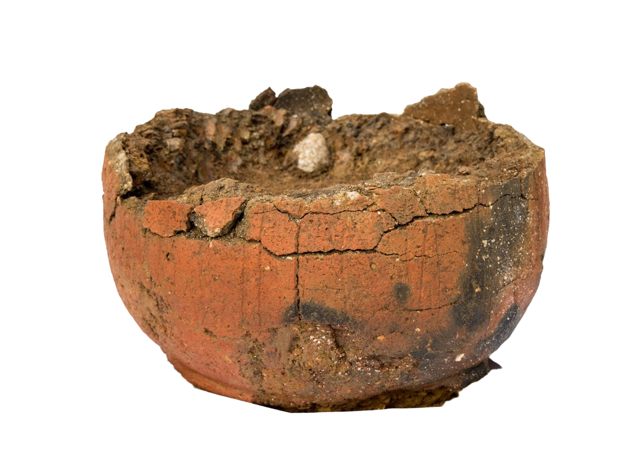
At Fenstanton Gravels 4, within the terminus of roundhouse 28.431, the base of a vessel and a carefully placed horse mandible were recovered and could represent a foundation or closure deposit. The single vessel placed upside down in the centre of roundhouse 5.63 at Alconbury 2 may represent a further example of a closure deposit (Fig. 3.34). The pit into which the pot was placed cut an earlier post-hole, which could have been associated with the original structure, suggesting the pit was dug during the 'abandonment' of the roundhouse. Within Pit Group 10.230, Brampton West 102, located to the west of the central ring ditch area, four early Iron Age vessels, comprising at least two jars, a single bowl and a further base sherd, had been deposited into pit 106802; while not complete the condition of the sherds suggests they were placed fairly soon after breakage. It is unclear if this depositional activity is related to the ring-ditches, but the potential significance of this area may be indicated by the fact that unlike other parts of Brampton West 102, which saw multiple recuts and additions, this area saw little modification or addition. It also continued to exert a degree of influence into the early Roman period with inhumation burials 10.198 and 10.192 placed to the west of the ring-ditches (see Chapter 4). A similar deposit was recorded at Brampton West 100, where a pair of shallow pits was recorded towards the centre of the settlement. One of these, pit 720642, contained sherds from two large slack-shouldered jars alongside fragments of a saddle quern (F72078) made from Tourmaline granite. The combination of these items within the pit probably reflects the links between storage and milling. The deposition of an 'exotic' stone type potentially indicates that this is a significant, deliberately placed, deposit marking the end of use (Shaffrey 2024h; see Fig. 3.14).
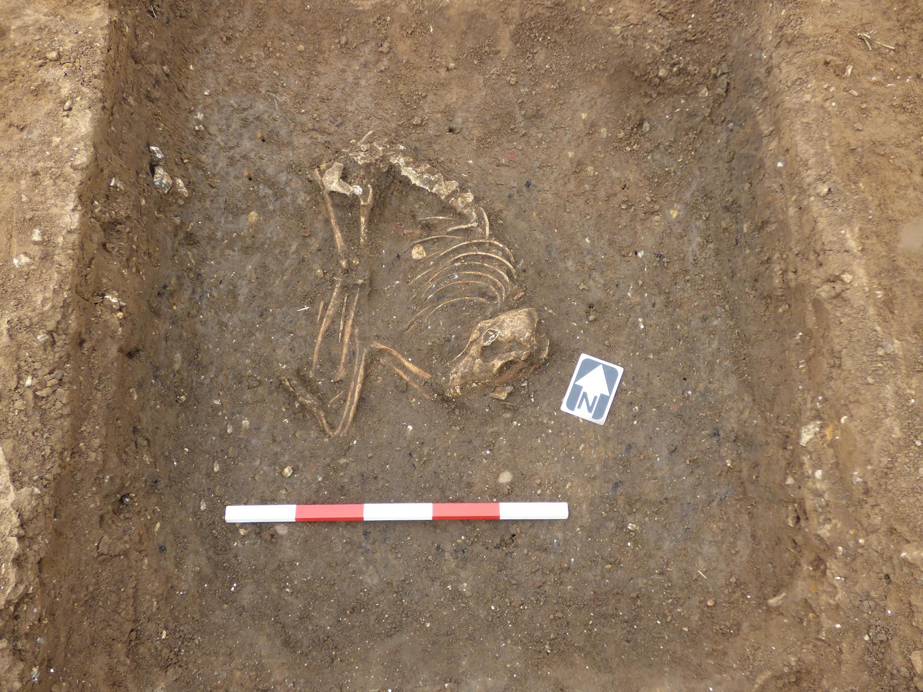
Structured deposits of animal remains, in contrast, were more difficult to detect, except instances where, as previously discussed, they were associated with other artefacts. At Brampton West 102, the articulated remains of a dog, with the skull located at the lower end, were placed within the fill of ditch 10 (Fig. 3.35). The association of dog remains with structured deposits echoes the association of a dog-tooth amulet with an infant burial at Bar Hill 5 (see below). Other finds from the ditch included a pair of U-sprung tweezers (F10167) and a strip bow brooch fragment (F10171) dating to the early to late 1st century AD; the latter was associated with the dog burial. Further animal burials were recorded at Brampton West, where a series of partial animal burials were recorded within the middle Iron Age Pit Group 10.569, at TEA 10, unattributed to settlement. The burials comprised the complete skeleton (aside from the cranium) of a young adult pig (around 3 years of age at death), and a partial young horse burial (no older than 15 months) was also recovered from context 100226.
While limited, the range of identified structured deposits does suggest patterns of deposition closely tied to the closure or disuse of features. In some cases this included the deposition of objects previously associated with the feature, while in others the deposition of various animal remains could have a range of symbolic connotations, although as noted at Brampton West at least six animals that were deposited into a pit probably died from disease, suggesting caution should be exercised in interpreting all animal burials as 'ritual' or even 'structured' (see Harding 2015). The totemic significance of animal remains is further underscored by the presence of three dogs and a single pig-tooth amulet (F38055) from Bar Hill 5. One of these was associated with inhumation burial 381956; this association potentially foreshadows or mirrors beliefs and burial practices better known from the Roman world (see Marshall and Humphreys 2024). This burial was one of several examples of articulated or disarticulated remains that were found incorporated within settlement features or located within the boundaries of the settlement. The nature and associated symbolism of these is examined in the following section.
A total of 29 burials of Iron Age date were recorded, comprising 15 inhumations and 14 cremations; alongside these there were 112 fragments of disarticulated remains (Henderson and Walker 2024g; Table 3.3; Table 3.4; Fig. 3.36). The majority of the burials comprised adults, although only four of these (two males and two females) could be sexed. The remainder of the adult burials comprised cremations. A relatively high proportion of the remains comprised subadults (perinatal-17 years old), with perinatal remains, in particular, occurring widely, which could reflect high mortality rates among the population. With regard to the adults, these were typically aged between 18 to 35 years, but the low number of burials prohibits more nuanced analysis of population demographics (a detailed review is provided in Henderson and Walker 2024g).
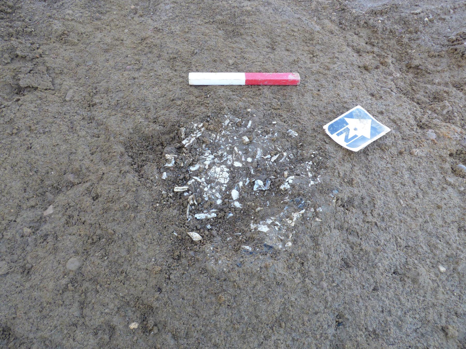
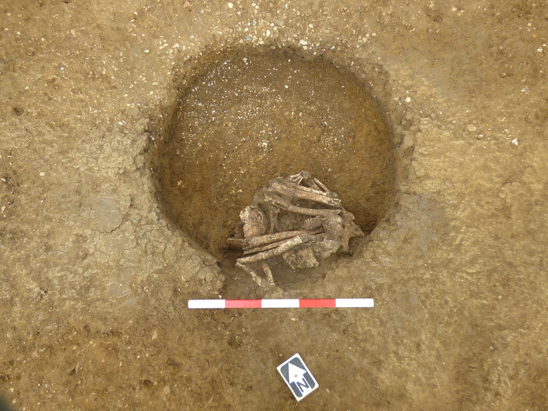
| Settlement | Group | Land use/Context | Burial Type | Sex* | Age* | Radiocarbon Dates | Istope/aDNA | Urned | Alignment/Position | Grave Goods |
|---|---|---|---|---|---|---|---|---|---|---|
| Alconbury 2 | 5.300 | Enclosure 5 | Cremation | Indet. | Indet. | - | - | Unurned | - | - |
| Brampton West 1 | 7.151 | - | Inhumation | - | Adult | 350-50 cal BC | - | - | N/S Pos. crouched | - |
| Brampton West 2 | 7.664 | - | Inhumation | Indet. | Subadult, Perinatal | 150 cal BC - cal AD 60 | - | - | - | - |
| Brampton West 100 | 7.3 | - | Inhumation | Indet. | Indet. Adult | 360-50cal BC | Isotope, aDNA | - | E/W crouched | Undiagnostic copper-alloy fragments |
| Brampton West 102 | 10.152 | - | Inhumation | Female | Young Adult 18-25 years | - | Isotope, aDNA | - | NE/SW crouched | Undiagnostic pottery from grave fill |
| Brampton West 102 | 10.718 | Ditch 10.21 | Inhumation | Indet. | Subadult, Perinatal | - | - | - | - | - |
| Brampton West 102 | 10.722 | Ditch 10.21 | Inhumation | Indet. | Subadult, Perinatal | - | - | - | - | - |
| Brampton West 102 | 10.410 | - | Cremation | Indet. | Indet. | - | - | Unurned | - | |
| Brampton West | 10.413 | - | Cremation | Indet. | Indet. | - | - | Unurned | - | Animal remains intermixed in fill |
| Brampton West 102 | 10.62 | - | Cremation | Indet. | Indet. | 40 cal BC - cal AD 120 | - | Unurned | - | - |
| Brampton West 102 | 10.386 | Cemetery 102 | Cremation | Indet. | Indet. | - | - | Unurned | - | Single sherd Iron Age pottery |
| Brampton West 102 | 10.384 | Cemetery 102 | Cremation | Indet. | Indet. Adult | - | - | Unurned | - | - |
| Brampton West 102 | 10.385 | Cemetery 102 | Cremation | Indet. | Indet. | - | - | Unurned | - | - |
| Brampton West 102 | 10.720 | Cemetery 102 | Cremation | Indet. | Indet. Adult | - | - | Unurned | - | - |
| West of Ouse | 16.73 | Cemetery 3 | Cremation | Indet. | Indet. | Unurned | ||||
| Fenstanton Gravels 1 | 31.75 | - | Cremation | Indet. | Indet. | 150 cal BC - cal AD 70 cal | - | Unurned | - | - |
| Fenstanton Gravels 4 | 28.432 | - | Inhumation | Female | Indet. Adult | 390-200 cal BC | aDNA | - | NW/SE crouched | Associated with disarticulated remains 28.610 |
| Fenstanton Gravels 4 | 28.538 | - | Cremation | Indet. | Indet. Adult | 360-50 cal BC | - | Unurned | - | - |
| Fenstanton Gravels 4 | 28.539 | - | Cremation | Indet. | Indet. | - | - | Unurned | - | - |
| Conington 3 | 32.202 | - | Inhumation | Indet. | Subadult, Perinatal | - | - | - | - | - |
| Conington 3 | 32.197 | - | Cremation | Indet. | Indet. | - | - | Unurned | - | - |
| Bar Hill 3 | 410757 | Roundhouse 41.62 | Inhumation | Indet. | Subadult, Perinatal | - | - | - | - | - |
| Bar Hill 3 | 41.100 | Ditch 41.5 | Cremation | Indet. | Indet. Adult | - | - | Unurned | - | - |
| Bar Hill 5 | 38.74 | Inhumation | Indet. | Subadult, 1-5 years | - | Isotope | - | - | - | |
| Bar Hill 5 | 38.74 | Inhumation | Indet. | Subadult, 7-11 months | 370-120 cal BC | Isotope | - | - | - | |
| Bar Hill 5 | 381956 | Enclosure 11 (upper fill of ditch 38.128) | Inhumation | Indet. | Subadult, Perinatal | 160 cal BC - cal AD 30 | - | - | - | Perforated dog tooth amulet (F38189) Within same fill but not directly associated with 'Bury Diadem' (F38190) , 'Broadoak Boars' (F38192) |
| Bar Hill 5 | 38.135 | - | Inhumation | Male | Indet. Adult | 180-1 cal BC | Isotope, aDNA | - | NE/SW crouched | - |
| Bar Hill 5 | 381192 | 38.178 (Enclosure 9) | Inhumation | Indet. | Subadult, Perinatal | 160 cal BC - cal AD 30 | - | - | - | - |
| Bar Hill 5 | 38.318 | Inhumation | Male | Early-mid adult 26-35 years | - | - | - | E/W crouched | - |
| Settlement | Group | Context | Land use | Period | Elements | Adults | Subadult | Total |
|---|---|---|---|---|---|---|---|---|
| Alconbury 1 | 159 | 53850 | LB2 | M-LIA | 3 | 1 | 0 | 1 |
| Alconbury 2 | 119 | 53225 | F2 | LIA | 6 | 0 | 1 | 1 |
| Alconbury 2 | 126 | 50240 | E5 | LIA | 2 | 1 | 0 | 1 |
| Bar Hill 5 | 48 | 380173 | - | M-LIA | 2 | 0 | 1 | 1 |
| Bar Hill 5 | 318 | 380389 | C1 | LIA | 2 | 1 | 0 | 1 |
| Bar Hill 5 | 380825 | - | LIA | 1 | 1 | 0 | 1 | |
| Bar Hill 5 | 1 | 381280 | LB1 | LIA | 1 | 0 | 1 | 1 |
| Bar Hill 5 | 85 | 382754 | E9 | LIA | 3 | 0 | 1 | 1 |
| Bar Hill 5 | 8 | 384099 | - | M-LIA | 1 | 1 | 0 | 1 |
| Bar Hill 5 | 83 | 385386 | E14 | M-LIA | 2 | 0 | 1 | 1 |
| Bar Hill 5 | 96 | 385589 | - | LIA | 3 | 1 | 0 | 1 |
| Bar Hill 5 | 265 | 385747 M. | - | M-LIA | 2 | 0 | 1 | 1 |
| Bar Hill 3 | 34 | 410042 | E2 | LIA | 2 | 1 | 0 | 1 |
| Bar Hill 3 | 55 | 410120 | E2 | LIA | 3 | 0 | 1 | 1 |
| Bar Hill 3 | 12 | 410314 | E2 | LIA | 1 | 1 | 0 | 1 |
| Bar Hill 3 | 89 | 410375 | - | M-LIA | 1 | 1 | 0 | 1 |
| Bar Hill 3 | 17 | 410598 | - | LIA | 2 | 1 | 0 | 1 |
| Bar Hill 3 | 73 | 410636 | - | LIA | 3 | 1 | 0 | 1 |
| Bar Hill 3 | 88 | 410757 | - | M-LIA | 1 | 0 | 1 | 1 |
| Bar Hill 3 | 44 | 410791 | E2 | LIA | 1 | 1 | 0 | 1 |
| Bar Hill 3 | 12 | 410917 | E2 | LIA | 8 | 0 | 1 | 1 |
| Bar Hill 3 | 92 | 410941 | - | LIA | 1 | 0 | 1 | 1 |
| Bar Hill 1 | 4 | 460468 | - | M-LIA | 5 | 1 | 0 | 1 |
| Bar Hill 1 | 4 | 460472 | - | M-LIA | 2 | 1 | 0 | 1 |
| Brampton West 102 | 46 | 107660 | - | M-LIA | 2 | 0 | 1 | 1 |
| Brampton West 102 | - | 601273 | - | M-LIA | 2 | 1 | 0 | 1 |
| Brampton West 102 | - | 601406 | - | M-LIA | 2 | 1 | 0 | 1 |
| Brampton West 102 | 204 | 602055 | - | LIA | 2 | 0 | 1 | 1 |
| Brampton West 102 | 7 | 604510 | E111 | LIA | 3 | 1 | 0 | 1 |
| Brampton West 102 | 44 | 603042 | - | LIA | 2 | 1 | 0 | 1 |
| Brampton West 102 | 45 | 106703 | R101 | LIA | 3 | 1 | 0 | 1 |
| Brampton West 102 | 90 | 603546 | - | LIA | 1 | 1 | 0 | 1 |
| Brampton West 102 | 91 | 104686 | R102 | LIA | 4 | 1 | 0 | 1 |
| Brampton West 102 | 92 | 104632 | R102 | LIA | 7 | 1 | 0 | 1 |
| Brampton West 102 | 617 | 604334 | - | LIA | 3 | 0 | 1 | 1 |
| Brampton West 102 | 711 | 107087 | LB106 | LIA | 6 | 1 | 0 | 1 |
| Brampton West 100 | 183 | 721837 | E102 | LIA | 3 | 0 | 1 | 1 |
| Brampton West 1 | 171 | 731277 | E1 | LIA | 2 | 1 | 0 | 1 |
| Conington 3 | 215 | 322562 | - | EIA | 2 | 1 | 0 | 1 |
| Conington 3 | 126 | 334218 | E12 | M-LIA | 2 | 1 | 0 | 1 |
| Fentanton Gravels 4 | 574 | 280801 | F12 | LIA | 5 | 1 | 0 | 1 |
| Fentanton Gravels 4 | 610 | 281064 | - | M-LIA | 14 | 1 | 0 | 1 |
| Fentanton Gravels 1 | 63 | 310215 | - | LIA | 12 | 1 | 0 | 1 |
The relatively low number of burials is not unusual for the region, with Iron Age funerary practices in general tending to encompass a range of practices (Wait 1985, 84-122). This diversity reflects community diversity as well as bias and limitations within the archaeological evidence (Redfern 2008; Harding 2015). In general, funerary evidence in the middle Iron Age across England tends to be dominated by the presence of disarticulated remains, with a broad trend towards articulated burials in the late Iron Age (Redfern 2008; A. Taylor 2001, 65-8). Cremation burials appear in the late Iron Age and in the south of England are typically associated with the spread of Aylesford-Swarling pottery. The data from the A14 suggest a mixed range of practices but, as highlighted previously, the overall resolution of these is hampered by a number of factors. In the following section the wider patterns of Iron Age burial across the A14 are reviewed alongside a consideration of the types of burials and grave goods, with a particular focus on the role of disarticulated remains.
Considering the burial data over time there is a slight emphasis on inhumation during the middle Iron Age, with cremation burials forming a smaller component (Table 3.3). A single cremation burial, 16.73, was noted in the early Iron Age at West of Ouse, placed into the top of the earlier barrow, forming an association between the occupants of the site and the earlier phases of activity. The four possible middle Iron Age cremation burials were recorded at Fenstanton Gravels 4 (two burials; Fig. 3.36A), Brampton West 102 (one burial) and Alconbury 2 (one burial). These could reflect continuity with early Iron Age burial practices, although none of these were closely datable, and so could be later Iron Age in date. Inhumation is the dominant rite throughout the middle Iron Age with eight recorded examples, with an even split between adult and subadult burials. Adult burials were typically crouched, often being tightly flexed suggesting they were bound or wrapped. The subadult burials showed slight differences in their placement, with the single perinate from Bar Hill 3 being buried within the ditch fill, or as in the case of the double infant burial 38.74, above a relict waterhole. These had been placed into a stony surface above waterhole 38.77, and aDNA analysis showed that these infants were likely half-brothers with different fathers (Henderson and Walker 2024g). Both infants showed evidence of scurvy, while infant 381834 might also have suffered from rickets. The remaining subadults aged 7-11 months and 1-5 years old from Bar Hill 5 were placed within burial cuts. The dataset is too small to determine if this reflects the affording of particular burial rites based on age, although there was evidence for the continued placement of perinates into ditches during the late Iron Age.
The late Iron Age saw a notable increase in the number of perinate burials, with six examples, four of which were recovered from ditch fills. The presence of grave goods with 38.128, and the articulated nature of burials 10.718 and 10.722, suggests that these were not casually dumped but deliberately placed. In the case of burial 38.128, associated with a dog-tooth amulet (F38189) and potentially two Iron Age coins (F38190 and F38192) , this deposit was associated with the final phases of Enclosure 11. In contrast to the middle Iron Age, no individuals between the ages of 1 and 18 years old were recorded. The reasons for this are unclear, but could reflect biases within the archaeological data, or that these were buried/disposed of elsewhere. This accords with the potential treatment of adults, which, while present, continued to be recorded in low numbers. A closer examination of the contexts of burial suggests the majority of the middle to late Iron Age individuals were placed within the final fills of features. Although this possibly represents a convenient location for burial, it could also suggest an association between perinates and closure deposits. This, as will be discussed in the following section, is comparable to the ways in which disarticulated adult remains were incorporated into settlement deposits.
Adult burials of the late Iron Age comprised a mix of inhumation and cremation, with cremation being the predominant burial rite (Table 3.3). Inhumation burials continued to show a preference for crouched burials, overlapping with their middle Iron Age counterparts. There is some evidence for the grouping together of cremation burials into cemeteries during the late Iron Age, with a single cremation cemetery recorded at Brampton West. Cemetery 102 comprised four cremation burials, alongside three further pits. It is unclear if these additional pits represent further cremations, but at least two of them contained sherds of East Midlands Scored Ware and a lid-seated jar. The placement of the vessels recalls not only the previously discussed deposition of pottery within the Brampton West ring-ditch zone, but invites parallels with the wider Aylesford-Swarling tradition of urned cremation burial dating to the late 1st century BC to early 1st century AD. While examples of richly furnished burials are known within the Aylesford-Swarling tradition, these are atypical, with the majority instead typically containing low numbers of pottery vessels and/or personal ornaments or none at all, continuing the general trend of low-visibility burials of the Iron Age (Hill et al. 1999, 264). A second group of three cremation burials was recorded to the east of Enclosure 113 in Brampton West 102. As within Cemetery 102, these cremations were closely associated with a group of pits, several of which contained evidence of burning, alongside fragments of animal bone and sherds of pottery, perhaps indicative of further burials or feasting waste associated with the cremations. Of note was the presence of two early to mid-1st century AD copper-alloy brooches (F10123 and F10117) , 22 sherds of pottery and animal bone fragments, closely mirroring the range of grave goods noted at Hinxton (Hill et al. 1999). Taken as a whole this suggests that by the early 1st century AD, at least certain individuals within the settlement at Brampton West were being afforded novel forms of burial. The use of pottery vessels and other associated grave goods marks the site out from its neighbours, the significance of which will be examined further in the final section of this chapter. Having considered the evidence for the visible dead, the following section will examine the evidence of disarticulated remains, which forms the bulk of the data about the disposal of human remains.
Disarticulated remains formed the bulk of the human remains dataset, totalling 112 fragments (representing a minimum number of 43 individuals), suggesting, as at other sites, that these fragmentary remains represented the vestiges of 'normative' funerary rites (Table 3.4). These were recovered from multiple contexts within the settlement limits, with a notable increase in the late Iron Age. It is difficult to determine how much of this material was deliberately placed or became accidently incorporated into the fills of features. Hill has argued that individual bones were sometimes selected and placed around the margins of a settlement (1995, 105-8). Alternatively, as highlighted at Trumpington near Cambridge, it is possible that the dead were placed within middens and became incorporated into features through later disturbance (Evans et al. 2018, 164). Past discussions have tended to cite the role of excarnation, with the corpse being exposed and selected remains being brought back (Redfern 2008). The overall condition of the disarticulated remains suggest that decomposition took place naturally away from scavengers, as there was a general absence of weathering, cut marks or animal gnaw marks (Henderson and Walker 2024g).
On average these deposits comprised up to five elements, but larger deposits of up to 14 elements were noted. In at least one case this comprised twelve fragments of a skull that had been placed onto one of the basal fills of the late Iron Age waterhole 31.63, along with a fragment of quern stone and 13 sherds of pottery. This deposit likely represents a closure deposit associated with the final abandonment of Fenstanton Gravels 1. Cranial fragments were by far the most common element recovered across the scheme, with examples recovered from the fill of roundhouse 46.4 at Bar Hill 1 and roundhouse 31.52 at Fenstanton Gravels 1. The latter was accompanied by two corroded fragments of iron and could suggest a structured deposit. The potential significance of these is further underscored by the presence of a sub-rectangular comb (F38165) made from a fragment of human skull at Bar Hill 5 (Fig. 3.37). The comb is one of three known examples within the region, although examples are also known in France (Marshall and Humphreys 2024).
In light of this, it is tempting to see that particular elements were targeted for incorporation into settlement features, with skulls tending to predominate. Past discussions of Iron Age societies have highlighted the potential significance of skulls (Armit 2012), and this is reflected across Cambridgeshire by finds of disarticulated skulls and skull fragments, some of which show cut marks or modifications (Evans 2013, 67; Marshall and Humphreys 2024). To what degree other skeletal elements were deliberately selected is difficult to estimate, as various mechanics could lie behind their incorporation into the fills of features. The treatment of remains may have been contingent on the individual and their wider relationship within the community, suggesting a potential range of motivations, rather than a single underlying set of rules. This in turn can be further contextualised within the wide-ranging and diverse social networks taking place throughout the Iron Age, the nature of which are further considered in the final section.
A number of key themes have emerged from this examination of settlement development function alongside ritual elements of the sites and will be further discussed here with a particular focus on ideas of social connectivity throughout the period. The first half considers the nature of connectivity and settlement expansion in the middle Iron Age, with the final section exploring these themes within the context of the late Iron Age. This section does not purport to provide a comprehensive overview of the social dynamics of the period, but rather to signpost several key ideas that have emerged from the A14 data.
The middle Iron Age saw fundamental and widespread changes in the use of the landscape, setting in motion the development of a range of sites and associated economies. The observed pattern likely includes an element of settlement shift, and seasonal or punctuated activity. The rapid expansion of settlement during the middle Iron Age contrasts with the more limited evidence for settlement in the preceding periods. These earlier settlements appear to be largely defined by temporality, contrasting with the more permanent nature of settlement from the middle Iron Age. The mechanics behind this expansion in other parts of the country have typically been explained through ideas of population movement, albeit small-scale (Hill 2007, 23). The A14 isotopic and aDNA evidence indicates that most of the population were raised locally, according with the idea of small local movements rather than long-range migration (Henderson and Walker 2024g). The initial stimulus for this movement could be related to earlier patterns of transhumance, echoing patterns across the Thames Valley to the west and along the ridgeway of the A428 to the south. Across the length of the ridgeway are a number of Iron Age settlements, including Cambourne and further recently excavated examples. As at the A14, this area was sparsely occupied during the early Iron Age but saw substantial development and expansion in the middle to late Iron Age (Abrams and Ingham 2008; Wright et al. 2009; Wright 2022).
Over time the pattern of seasonally driven activity across the A14 could have given way to more formal arrangements or resulted in the creation of larger 'camps' and enclosures. The degree to which these were seasonally occupied is unclear, but the overall sense, especially with the sustained focus on water management, is that they became increasingly permanent settlements over time. As seen at Fenstanton Gravels 1, there was an expansion in the number of roundhouses over time, perhaps indicating an increase in population. Indeed, many of the A14 middle Iron Age sites in their initial phases are defined by 'unenclosed' settlements of roundhouses, although whether these represent the remains of seasonal or more permanent occupation is difficult to determine. While 58 examples of roundhouses were recorded, the number that represent domestic dwellings is unclear. At least seven had clearly defined post rings, while others could have functioned as animal pens (Allen et al. 1981; Noble and Thompson 2005, 30) or have been used for industrial/craft activities (Pope 2003, 268). In some cases, the ditches may have held fences (Lambrick and Robinson 2009, 109).
The movement of people and the expansion of settlements raise a second interrelated question regarding the size of the population groups occupying each of these sites. The relatively low number of burials prohibits nuanced analysis of the demographics of the population, but as at Claydon Pike in Gloucestershire it is possible that some of these settlements were only ever home to a single-family group shifting location over a century or more of occupation (Miles et al. 2007). The distribution and density of roundhouses across the A14 may reflect a complex mix of short-lived seasonal activities, differing functions but also the shifting settlement of family groups. There is a notable drop in the number of roundhouses (acknowledging the caveats presented above) from 40 to 17 by the late Iron Age, when the existence of larger agglomerated settlement units may suggest the presence of larger extended or multiple family groups. The increased emphasis on spatial division during the period may reflect further on aspects of land ownership and tenure, suggesting a degree of cooperation across the area (Giles 2007).
This is not, though, to suggest a peaceful picture of coexistence across the scheme. The presence of weapons, which could also have been used for hunting, does suggest that violence was a distinct possibility. Among the identified weaponry from middle to late Iron Age contexts was a range of clay sling shot at Brampton West 100 (F76199 and F76198) and an iron spear (F52062) at Alconbury 5 (Fig. 3.38). A fragment of a sword hilt (F38160) was also recovered from a late Iron Age context at Bar Hill 5. A number of individuals across the A14 were noted to have incidences of healed fractures, although it is difficult to gauge the degree to which these derived from interpersonal violence, versus accidents (Henderson and Walker 2024g). Adult female burial 28.432 had a well-healed fracture in the distal shaft of the left ulna, caused by a blow to the arm. These are often interpreted as defensive injuries, occurring by raising the arm to protect the head, but again stress fractures and falls are possible alternative mechanisms. The potential for violence and/or social tension may have been managed through a variety of means, including social gatherings and a focus on clearly defined areas of settlement. It is possible that the close proximity of the A14 settlements led to a degree of fossilisation within land boundaries, creating defined units with an emphasis on clear spatial partitioning, which becomes increasingly evident in the late Iron Age.
As outlined in the preceding sections the move into the late Iron Age, when considered from a statistical perspective, represents one of decline, with a reduction in the overall number of settlements. As highlighted, however, this does not account for the expansion and development of a number of sites, which likely became the focus for much of the population within the region. These sites showed an increased emphasis on the organisation of space, echoing trends at other Iron Age sites. A comparable arrangement of features to Brampton West 102 was explored at Bradley Fen, Cambridgeshire, where a linear arrangement of middle Iron Age features, comprising roundhouses, structures, waterholes, pits, and features associated with metalworking were recorded across a large area (Knight and Brudenell 2020, 307). At Bradley Fen, the middle Iron Age concern of regulating space was expressed not through enclosure but by the greater zoning of activities (Knight and Brudenell 2020, 337). A degree of patterning was also identified at the more 'open' settlements identified at Biddenham Loop in Bedfordshire where four discrete farmsteads were identified within c. 20m of the river Great Ouse floodplain (Luke 2008, 39). It is possible that these settlements became host to largely aggregate groups, potentially larger extended families or multiple groups, creating larger social entities across the landscape. Across the UK during this period there is a clear move towards larger aggregate groups, most notably in the form of 'kingships' (Hill 2007). These new 'relationships' are partly reflected in the increased use of coinage, which rather than being employed in exchanges probably helped to articulate emerging ties of clientage and dependency (Fitzpatrick 1992; Table 3.5). To what degree these sites were engaged with the emergent polities of the period, including the tribal groups of Trinovantes and Catuvellauni, is unclear. The presence of coinage, albeit in low quantities, does suggest engagement with wider networks, an impression reinforced by the presence of other imported materials (Fig. 3.39). Of note is the relatively high numbers of coins from Bar Hill, where five of the nine Iron Age coins recorded from the A14 work were recovered, echoing the pattern at Northstowe to the north where all 12 identifiable Iron Age coins recovered were attributable to either the Trinovantes or the Catuvellauni (Aldred and Collins forthcoming).
| Alconbury | Bar Hill | Brampton West | Conington | Fenstanton Gravels | River Great Ouse | West of Ouse | ||||||||||||
|---|---|---|---|---|---|---|---|---|---|---|---|---|---|---|---|---|---|---|
| Brooch Types | S3 | S3 | S5 | - | S1 | S2 | S100 | S102 | S201 | - | S3 | - | S3 | S4 | - | - | S2 | Total |
| MIA | 1 | 1 | ||||||||||||||||
| LIA Drahtfibel and Nauheim | 2 | 1 | 1 | 1 | 1 | 6 | ||||||||||||
| LIA Other | 1 | 1 | 3 | 1 | 6 | |||||||||||||
| Simple One Piece | 4 | 1 | 1 | 1 | 3 | 1 | 1 | 2 | 1 | 15 | ||||||||
| Colchester | 3 | 1 | 1 | 2 | 2 | 5 | 5 | 1 | 14 | 1 | 1 | 1 | 3 | 2 | 42 | |||
| Cylindrical Spring Case | 1 | 2 | 3 | 2 | 8 | |||||||||||||
| Penannular - Fowler C | 1 | 2 | 1 | 2 | 6 | |||||||||||||
| Total Brooches | 3 | 13 | 51 | 3 | 12 | 1 | 1 | 84 | ||||||||||
| Total Coins | 1 | 4 | 2 | 1 | 8 | |||||||||||||
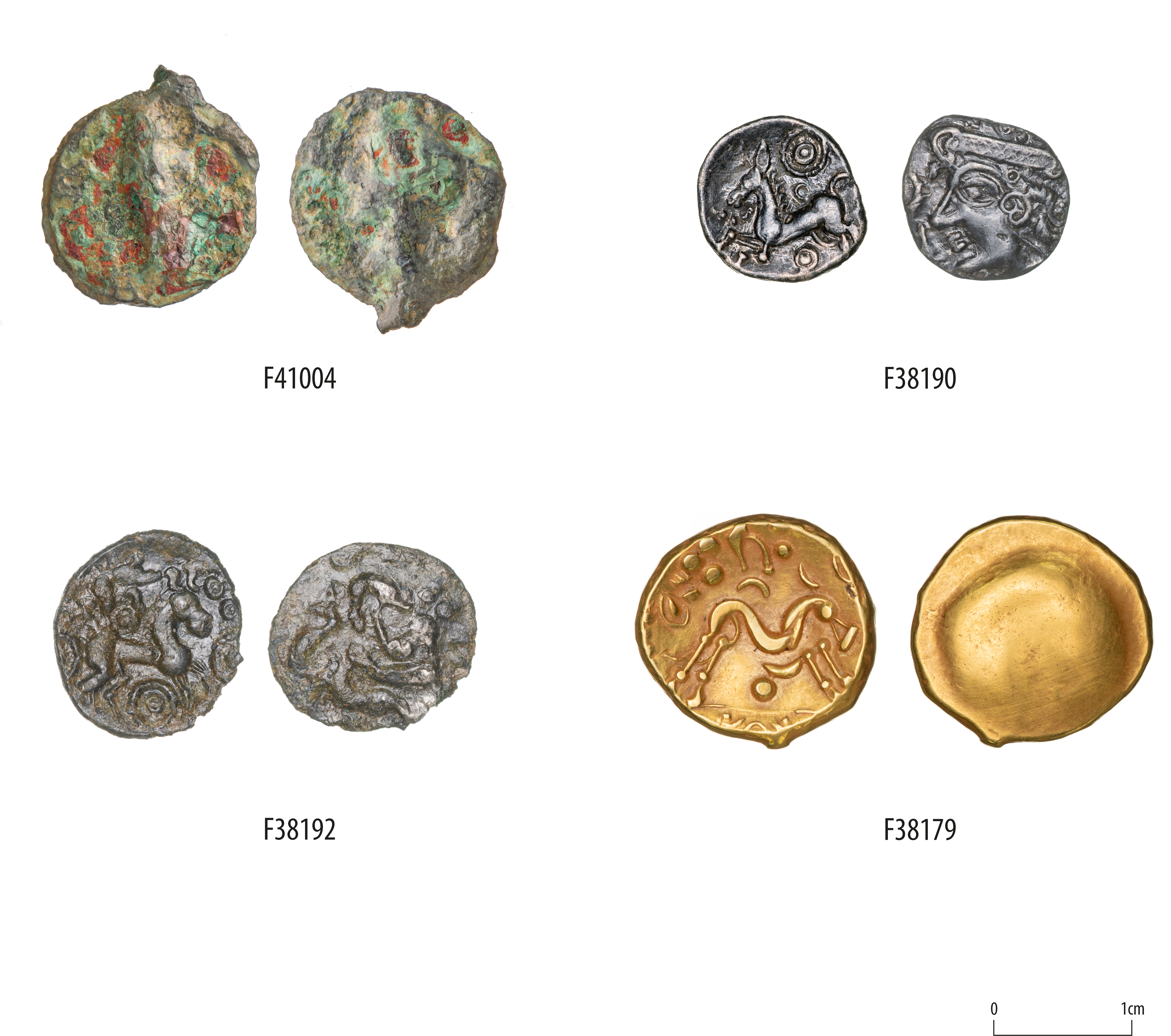
In contrast, the agglomerated site at Brampton West contained comparatively low numbers of coins, comprising two issues from Trinovantes and Catuvellauni. This could reflect aspects of site function and the wider social role played by coinage. Offsetting this apparent dearth of coinage, Brampton West contained a relatively high proportion of brooches during the late Iron Age reinforcing the impression of the site as relatively well connected (Table 3.5; Fig. 3.40). This extended to the importation of toilet sets, although there is some evidence of these being produced at Brampton West. Other items that were seemingly being exchanged during the Iron Age included butt beakers, which as indicated by geochemical and petrographic analysis appear to have moved westward between Bar Hill and Brampton West, comparing well with the evidence for the movement of Aylesford-Swarling pottery from the Cam valley to Wardy Hill, which is a similar distance (Sutton et al. 2024). The fact that this exchange is focused on butt beakers highlights the potential social roles of these vessels, and the associated changes in patterns of consumption associated with these. As mentioned in the introduction these changes in patterns of consumption form part of a broader suite of changes in material culture, including brooches, coinage and changes in funerary practice associated with developments in late Iron Age societies. At their peak the Iron Age settlements of the A14 were clearly well connected and able to draw on a range of wider networks and resources. While this may not have been on the scale of some of their neighbours to the south or west, it does suggest the existence of a range of successful agricultural communities. This success was, however, seemingly followed by a second phase of disruption immediately preceding the arrival of the Romans.

The 1st century BC clearly represents the apogee of the A14 settlements, with large and extensive agricultural landscapes in operation. As highlighted in this chapter these were concentrated within the western, central and eastern ends of the scheme, extending beyond the limits of the A14 and drawing in a wide range of sites. By the end of the century there is evidence for contraction and a potential decline in the level of activity taking place. This is notable at Brampton West and Bar Hill, where the scale of enclosures and associated features contrasts with the earlier part of the century. The mechanics and processes behind this are clearly multiple and range from environmental to social factors. At Bar Hill 3 the enclosures appeared to persist into the 1st century AD, although in a much reduced form, echoing the patterns at Bar Hill 5, where activity shifted to a series of smaller rectilinear enclosures. In the case of Brampton West, Brampton West 100 and Brampton West 2 persisted into the early Roman period operating on a much-reduced scale, comprising a handful of agricultural features (see Chapter 4). At Brampton West 102 the 'final' phases of the site are characterised by further modifications to the enclosure ditches. These saw the reestablishment of the enclosures on a slightly different axis and a realignment of the trackways. Current dating evidence suggests these features were potentially still open into the mid-1st century AD, but seemingly not persisting much if at all beyond the Conquest horizon. Associated with the final phase of the enclosure was a single pottery kiln, 10.706. Within the kiln were the remains of an early to mid-1st century AD polychrome glass bowl (F10306) and three copper-alloy Colchester brooches (F10307 , F10310 , F10352) , heralding the arrival of the next major architects of change within the A14 landscape, the Romans.
Internet Archaeology is an open access journal based in the Department of Archaeology, University of York. Except where otherwise noted, content from this work may be used under the terms of the Creative Commons Attribution 3.0 (CC BY) Unported licence, which permits unrestricted use, distribution, and reproduction in any medium, provided that attribution to the author(s), the title of the work, the Internet Archaeology journal and the relevant URL/DOI are given.
Terms and Conditions | Legal Statements | Privacy Policy | Cookies Policy | Citing Internet Archaeology
Internet Archaeology content is preserved for the long term with the Archaeology Data Service (ROR). Help sustain and support open access publication by donating to our Open Access Archaeology Fund.
 Home
Home