Cite this as: West, E., Christie, C., Moretti, D, Scholma-Mason, O. and Smith, A. 2024 A Route Well Travelled. The Archaeology of the A14 Huntingdon to Cambridge Road Improvement Scheme, Internet Archaeology 67 (Monograph 32). https://doi.org/10.11141/ia.67.22
Of all of the periods represented by the archaeology of the A14, it was the first four centuries AD that witnessed among the most intense human activity across most of the landscapes, from the gravel terraces and floodplain of the River Great Ouse in the west to the claylands in the east. This was a well-exploited and populated rural landscape, much of it book-ended between two larger nucleated settlements or 'small towns' at Godmanchester and Cambridge. Although there was demonstrable continuity from the late Iron Age in many sites, there were also significant developments over this period, much of which was directly or indirectly stimulated by the land's incorporation into the Roman state. This chapter will explore these developments through examinations of the physical evidence for settlements, buildings and landscapes, and an assessment of the varied socio-economic and ritual activities evidenced at the A14 sites over time.
Use top bar to navigate between chapters
A total of 13 settlements dating to the Roman period were identified across the A14 (Fig. 4.1). The majority of these can be classified as 'complex farmsteads' comprising systems of conjoined enclosures or a single intensively sub-divided enclosure (Allen and Smith 2016, 28). Alongside these, elements of a probable villa complex and two possible nucleated settlements were recorded. A summary of these settlements is provided within Table 4.1 (along with references to the relevant online reports).
At the western end of the A14 seven Roman period settlements were identified (Figs 4.1 and 4.2). The northernmost, Alconbury 4, comprised a series of rectilinear enclosures, defining the periphery of a probable nucleated settlement. The complex farmstead at Alconbury 3 to the south consisted of a series of sub-divided enclosures. At Brampton West, to the south of Alconbury, two complex farmsteads were recorded. The northernmost, Brampton West 100, encompassed two areas of activity, with evidence for pottery production in both. Brampton West 201, located towards the southern end of the Landscape Block, comprised two distinct phases of activity. In the early Roman period, the farmstead consisted of a series of pottery kilns and a small enclosure. In the 2nd century AD a 'new' farmstead was established to the south of the kilns.
The complex farmstead at West of Ouse 3, to the south of Brampton West, comprised a series of enclosures, trackways, and several pottery kilns. Located to the south-east, activity at West of Ouse 4 was centred upon a further group of pottery kilns. Following the disuse of the kilns around the mid-2nd century AD, both settlements were focused on agricultural production, before falling out of use around the later 3rd century AD. Activity at West of Ouse 4 was probably closely related to developments on the eastern side of the river at River Great Ouse 2. Here an early Roman farmstead was recorded alongside a series of planting trenches. This expanded into a larger complex farmstead in the 2nd century AD and during the later Roman period the farmstead was redeveloped into a villa, although only the periphery of this was excavated.
Within the centre of the A14 corridor three Roman settlements were identified at Fenstanton Gravels. Fenstanton Gravels 4 appeared to form the focus of activity, with Fenstanton Gravels 3 and 5 possibly operating as 'satellite' settlements. The latter were both associated with a series of planting trenches. The periphery of a possible roadside settlement was recorded at Conington 4, to the east of Fenstanton Gravels. The early phases of the settlement were associated with an enclosure system and several blocks of planting trenches.
At the eastern end of the A14 scheme a complex farmstead was recorded at Bar Hill 5. This comprised a sequence of enclosures associated with pastoral farming. Further agricultural activity associated with this settlement was recorded in TEA 37. Bar Hill 2 lay at the easternmost extent and comprised the remains of an enclosed farmstead, defined by a single sub-divided enclosure.

The A14 settlements are situated within a wider Roman landscape that was characterised as part of the Cambridgeshire Fen Edge Case Study in the University of Reading's Roman Rural Settlement Project, which formed part of a wider overview of the Central Belt region, extending from South Wales to Cambridgeshire (Smith 2016a, fig. 5.1). A total of 72 farmsteads, four villas, nine nucleated settlements, five pottery production sites, two religious sites and twelve field systems were recorded within this Case Study area (Smith 2016a, 193). Among the nucleated settlements are the Roman 'small towns' at Cambridge (Duroliponte) and Godmanchester (Durovigutum), which, as noted above, lie towards the eastern and western ends of the A14 scheme (Figs 4.1 and 4.3). These 'small towns' were connected to each other by the Via Devana Roman road (Margary 24), which was probably set out in the mid/third quarter of the 1st century AD and connected Colchester to Chester (Evans and Ten Harkel 2010, 36). Roman Cambridge developed from an extensive late Iron Age settlement (Alexander and Pullinger 2000), whereas the earliest activity at Godmanchester has been suggested as the remains of two possible Claudian/Neronian 'forts' (Green and Malim 2017, 63), though the existence of these 'forts' is not substantiated by the evidence (Millett 2019, 759). The site developed into a 'small town' from the later 1st century AD, reaching its height during the 2nd century AD, with a possible mansio and bathhouse (Smith and Fulford 2019; Jones 2003; for critique of the mansio see Millett 2019). Branching off from Godmanchester is a second road extending in a south-westerly direction towards Sandy (Margary 22), passing through the eastern extent of the River Great Ouse 2 (Fig. 4.3). Excavations across the road suggest it was set out in the 1st century AD (see MCB17569) (Green and Malim 2017, 65). Both the Via Devana and the Sandy road intersect with Ermine Street (Margary 2b), extending from London, through Godmanchester and the settlement at Water Newton (Durobrivae), to York.
Since the publication of the Cambridgeshire Fen Edge Case Study, archaeological investigations have been advanced on a number of important Iron Age and Roman sites in the vicinity of the A14. This includes excavations at Northstowe (Aldred and Collins forthcoming), North-West Cambridge (Evans and Lucas 2020; Brittain and Evans 2019), and at Dairy Crest and Cambridge Road, Fenstanton (Ingham 2022). To the south of the A14, as part of the A428 Black Cat to Caxton Gibbet Improvement Scheme, a range of Iron Age and Roman farmsteads were recorded (Wright 2022). Although all of these sites are referenced within this chapter, a broader study of the Roman landscape around the A14 is reserved for a wider synthesis of the hinterlands of Godmanchester and Cambridge in the project's landscape monograph (West et al. forthcoming). This synthesis uses the much greater body of Roman sites known and recorded in the Cambridgeshire HER (as opposed to the sites mostly derived from the Roman Rural Settlement Project in Figure 4.3) that are beginning to redraw the nature of Roman rural settlement and important nodal settlements around Cambridge and Godmanchester.
By the time of the Roman Conquest a number of the Iron Age sites on the A14 had been abandoned (see Chapter 3), while others continued to be occupied up to and beyond the mid-1st century AD. This period was characterised not only by the initial invasion in AD 43, but the subsequent expansion of the Roman state and a series of revolts. Previous surveys of the period have frequently focused on the impact of these historical events and their definition within the archaeological record (Dawson 2000a, 108; Wallace 2016; Fulford and Brindle 2016). This has often resulted in change being explained through reference to known historical events, creating an artificial divide between the Iron Age and Roman period (Wallace 2016, 126), and comes at the expense of examining the poly-causal nature of change in the later 1st century BC to the 1st century AD, and its varied regional effects (Hill 2007; Creighton 2006). Instead, these historic events need to be understood within their local context, examining the data from a 'bottom up' rather than a 'top down' approach. In the following section, two strands of data are examined to explore the definition and nature of the post-Conquest period across the A14; the artefactual evidence, followed by a review of the sites themselves.
Archaeologically the definition of the Claudian/Neronian period is ambiguous, with artefact and radiocarbon date ranges extending either side of AD 43 (see relevant radiocarbon dates in Table 4.2). The following is a brief summary of the main datable artefacts of this period recovered from across the A14 scheme. Further details are found in the relevant specialist overviews.
| Settlement | Feature | Sample | Material Dated | Labcode | δ13C relative to VPDB | Radiocarbon Age BP | Radiocarbon Date (95.4% Probability) |
|---|---|---|---|---|---|---|---|
| Brampton West 100 | Inhumation Burial 10.192 | 107389 | Human Bone: - | SUERC-91524 (GU53800) | -20.2 | 1987±26 | 50 cal BC - cal AD 120 |
| Brampton West 100 | Inhumation Burial 10.198 | 107297 | Human Bone: - | SUERC-91525 (GU53801) | -19.9 | 1985±26 | 50 cal BC - cal AD 120 |
| Brampton West 100 | Ditch 7A.184 | 72172 | Animal bone- Skull: Cattle | SUERC-98139 (GU57546) | -22.8 | 1976±28 | 50 cal BC - cal AD 130 |
| West of Ouse 3 | Kiln 14.269 | 14508 | Charred Cereal grains: Triticum sp. | SUERC-91376 (GU53714) | -22.8 | 1971±25 | 40 cal BC - cal AD 120 |
| Fenstanton Gravels 4 | Ditch 28.263 | 28452 | Charred Cereal grains: Triticum spelta | SUERC-91387 (GU53722) | 2029±25 | 100 cal BC - cal AD 70 | |
| Fenstanton Gravels 4 | Pit 283579 | 28594 | Cereal: Triticum sp. | SUERC-91460 (GU53724) | 1973±24 | 40 cal BC - cal AD 120 | |
| Fenstanton Gravels 4 | Inhumation Burial 28.529 | - | Human bone: - | SUERC-97742 (GU57429) | -19.1 | 1983±25 | 50 cal BC - cal AD 120 |
| Conington 4 | Waterhole/Well 32.1 | 320947 | Animal Bone: red deer | SUERC-93232 (GU54663) | -22.2 | 2001±25 | 50 cal BC - cal AD 110 |
| Bar Hill 3 | Inhumation Burial 41.61 | - | Human bone: - | SUERC-85559 (GU50645) | - | 1971±24 | 40 cal BC - cal AD 120 |
| Bar Hill 5 | Inhumation Burial 38.318 | - | Human bone: - | SUERC-97751 (GU57438) | -20.1 | 2032±25 | 110 cal BC - cal AD 70 |
Much of the ceramic assemblage can be hard to date precisely and separating pre-Flavian and post-Flavian material is particularly difficult (Anderson and Brudenell 2010, 48). Aylesford-Swarling Wares continue to occur in varying quantities across the A14 into the mid- to late 1st century AD (Sutton et al. 2024), although there is an apparent decline from around the AD 60s (Lyons 2024). During this period Aylesford-Swarling Wares are found alongside vessels in the Gallo-Belgic 'tradition'. These appear in increasing quantities from c. 25 BC to AD 85, comprising both imported and locally made examples (Pitts 2017, 46). Locally produced Gallo-Belgic forms were recorded across the A14, with butt beakers being the principal form, alongside examples of platters and girth beakers (Lyons 2024; Sutton et al. 2024) (Fig. 4.4). At Fenstanton Gravels 4 and Bar Hill 5 these included copies of terra nigra plates, produced in the post-Conquest period, but remaining in use until c. AD 80. Given the persistence of these into the later 1st century AD, it is probable that some relate to the Flavian redevelopment of the settlements, rather than the Claudian/Neronian period.
At Brampton West, sherds of imported terra rubra, terra nigra and Lyon Ware were recovered. Alongside these, very small quantities of imported Gallo-Belgic white ware were recovered from across the A14. Other contemporary pottery includes a sherd of samian stamped by the potter PAESTOR, dating to c. AD 35-60 from Brampton West 100 (Monteil 2024b). Comparable examples have to date only been recorded at Colchester and Waddon Hill (Hartley and Dickinson 2011, 6). At several of the A14 sites, sherds of Claudio-Neronian samian were recovered, but these could have remained in use beyond the 1st century AD (Willis 1998; 2004).
From the fill of kiln 10.706 at Brampton West 102, fragments of an early-to-mid 1st century AD polychrome cast glass ribbed bowl (F10306) and three copper-alloy Colchester brooches (F10307, F10310 , F10352 ) were recovered (see Chapter 3). This vessel was imported from the Mediterranean, although whether this was done directly or through intermediaries is unclear. Evidence for pre-conquest glass in Britain is generally rare (Cool 2020), although glass fragments were noted from Iron Age contexts on the A14. The association of the bowl with three Colchester brooches suggest a votive deposit associated with the closing of the kiln.
Other brooch styles of this period include Aucissa and Hod Hill types (see the finds overview for wider discussion; Humphreys and Marshall 2024b). The latter may have been introduced to Britain by the Roman army and initially could have been popular in military communities (Mackreth 2011, 133-4, 142). However, they have a broader distribution, appearing in early civilian centres such as London (Perring and Pitts 2013), and may also have been adopted or manufactured in Romano-British rural communities (Harlow 2021). Hod Hill brooches occur in small quantities across the A14, with a notable concentration at Fenstanton Gravels 4. Here they appear to be associated with the Flavian development of the site (see below).
Probable Claudio-Neronian 'militaria' include two examples of penannular strip/cuff bracelets, one from Brampton West 100 (F72002 ) and the second from Bar Hill 5 (F38036 ). This form of bracelet (Cool 1983, IX) is sometimes argued to be a type of military award given to veterans of the Claudian campaigns, the distribution of which could reflect areas in which Claudian veterans were settled, with a particular focus within the territory of the Catuvellauni and Trinovantes (Crummy 2005, 93). Harlow , while seeing a military origin as plausible, suggests that the style could have been dispersed by military examples being passed down through families or by local copies/imitations (2021, 103-8, fig 49; Humphreys and Marshall 2024b).
A limited range of Claudio-Neronian coinage was recovered from across the A14 (Humphreys and Bowsher 2024). Among these were two Claudian copies, from Brampton West 100 (F72006 ) and Fenstanton Gravels 4 (F28104 ), which probably fill the gap in supply between the end of availability of regular Claudian issues and the arrival of Neronian issues (i.e. AD 54-64). While typically linked to the Roman army these copies would have been circulated beyond the immediate military sphere, with comparable copies previously recorded at Cambridge and Godmanchester (Kenyon 1992, 377). Alongside these Claudian copies four issues of Nero were recovered. Two of these were found in later 1st to 2nd century AD contexts at Fenstanton Gravels 4.
The artefactual evidence outlined above gives some degree of chronological framework to assess the nature of settlement development in the early post-Conquest period, although the resolution is still relatively poor so that whether some changes occurred prior to or after the Conquest remains uncertain. As discussed in Chapter 3, the late Iron Age was a period of significant settlement disruption across the A14 sites, with 14 of the 23 settlements (c. 61%) being abandoned or shifting location (Fig. 4.2). At six of these, this disruption appears to have occurred at the very end of the Iron Age or early in the post-Conquest period. These settlements comprise Brampton West 1, 2 and 102, West of Ouse 2, Fenstanton Gravels 1, and Bar Hill 3.
At Brampton West, there was limited evidence for activity in the Claudio-Neronian period, which marks a major shift from the expansive middle to late Iron Age settlement. Located at the northern end of the Landscape Block, Brampton West 1 appears to have been 'abandoned' before the mid-1st century AD, while Brampton West 2 nearby, which was only established in the late Iron Age, may have continued a little beyond the mid-1st century AD, albeit on a reduced scale. To the south at Brampton West 102, a similar pattern is recorded, with some of the late Iron Age enclosure ditches continuing to be infilled during the later 1st century AD (these sites are discussed in Chapter 3 and shown on Fig. 3.23). A kiln at this site (10.706) contained a finds assemblage of Conquest date as noted above, while a field boundary or drainage ditch to the west of the main settlement contained a copy of a coin of Claudius (F72006 ). Ultimately the area of this settlement seems to have become partly incorporated into the expansion of Brampton West 100 during the Flavian period (see below).
Elsewhere, the Iron Age settlement at West of Ouse 2 appears to have been abandoned prior to the mid-1st century AD, with activity shifting north-west to West of Ouse 3; although the nature of the earliest phases at the latter site are ambiguous, the evidence does point to it having been 'established' early post-Conquest. This would seem, therefore, to be a good example of settlement shift rather than abandonment, which may otherwise have been the interpretation had not such a wide area been investigated. At Fenstanton Gravels 1 an enclosed late Iron Age settlement also seems to have been 'abandoned' or to have shifted location prior to the Conquest period, while the settlement at Bar Hill 3 had some limited early Roman activity, including an inhumation burial, but nothing that suggests sustained occupation by this time.
Although significant numbers of settlements were apparently being abandoned or shifting in location at this time, it is clear that at least seven existing settlements continued in use through and beyond the Conquest period, albeit some of them seemingly at a reduced level (Table 4.1). The earliest phases of Alconbury 4 are somewhat ambiguous but it appears to start in the late Iron Age and certainly continues through into the later Roman period, probably in the form of a nucleated 'village' settlement as evidenced by the geophysical survey (see below). Alconbury 2, in contrast, which was abandoned earlier in the late Iron Age, was not reoccupied (as Alconbury 3) until the 2nd century AD, although its associated field system may have remained in use in the intervening period. The late Iron Age to early Roman settlement focus may have shifted to the north, as features of this date were recorded nearby at Weybridge Farm (HER 363694).
As noted above, at Brampton West there was relatively little activity at this time, though Brampton West 100 did continue and may have expanded somewhat. Activity at River Great Ouse 2 appears to have been significantly reduced during the latest Iron Age-earliest Roman period, though it was not abandoned and soon after developed into a larger and thriving complex farmstead and eventually into a villa complex. At Fenstanton Gravels 4, the middle-late Iron Age farmstead expanded during the latest Iron Age to earliest Roman period before undergoing extensive redevelopment during the Flavian period (see below). Fenstanton Gravels 3 and 4 also seem to have continued into the Roman period, though the chronological resolution of these sites is poor.
Bar Hill 5 was the only settlement in that landscape block to continue to be occupied into the early Roman period and beyond, with a sequence of short-lived enclosures dug in the early to mid-1st century AD, soon replaced by a rectilinear enclosure and multiple ditches, suggesting an expansion of activity perhaps following a period of contraction. The precise chronology of these features is uncertain, owing to truncation by later Roman enclosures. The persistence of Bar Hill 5 into the Roman period could in part be due to its proximity to, and associations with, the settlement at Northstowe, which was occupied into the later Roman period (Aldred and Collins forthcoming).
Overall, it is clear that the state of 'settlement flux' within the latest Iron Age and early post-Conquest period is at least in part a continuation of longer-term trends, coming on the back of the disruption witnessed in the earlier part of the late Iron Age discussed in Chapter 3. It accentuates a broader pattern of settlement upheaval (abandonment, establishment and transformation) at this time observed in the wider region within University of Reading's Roman Rural Settlement Project, (Smith 2016a, 196). The ambiguity around the dating of this period makes interpreting the causes and mechanisms behind these changes difficult. No doubt the arrival of the Roman army in the wider region and its subsequent activities in the mid-1st century AD had some impact on the local communities. This would, however, have been highly varied and potentially unique to individual communities (Mattingly 2006). In a number of cases the effects of this process may have been negative, with a loss of rights and land, though to what degree land was confiscated or reallocated is difficult to measure. It has been previously suggested that large parts of southern Britain may have been incorporated into imperial estates following the Boudican revolt (Perring 2013, 10), though there is little convincing evidence for this (J. Taylor 2000). Within the A14 sites there are signs in the Flavian period for some element of perhaps indirect state involvement, or at the very least for new owners and systems of land management. This could suggest a process of land consolidation during this time, reflecting on wider policy changes after the various military events of the mid-1st century AD (Salway 1993, 91), or much more indirectly, the reshuffling of local power structures as a result of the new circumstances of imperial impositions.
The A14 landscape witnessed continued dynamism throughout the Roman period, with major changes in settlement form and land management (a summary of the main settlement phases is presented in Table 4.3). As noted above there were a number of sites that displayed continuity of activity from the late Iron Age, though many were transformed and there were also new establishments, some of them located on or near to sites of earlier settlement (Fig. 4.2). There were three 'new' settlements established during the Flavian period (Brampton West 201, West of Ouse 4 and Conington 4), while many others, like Fenstanton Gravels 4 and River Great Ouse 2, were greatly expanded. This could indicate a form of early settlement consolidation, with population perhaps shifting from some of the farmsteads that were 'abandoned' during the Conquest period (discussed above). Significantly, there were no further 'abandonments' at this time. This was part of a wider reconfiguration of settlement and landscape seen across the region during the late 1st to early 2nd century AD (Taylor 2007, 110; Smith 2016a), perhaps in part reflecting changes in function and land rights/ownership, including the emergence of systems of tenancy and estates (Kehoe 2007).
| Settlement | Early to mid-Roman | Later Roman | |
|---|---|---|---|
| Early Roman | Mid-Roman | ||
| c. AD 70-150 | c. AD 150-250 | c. AD 250-410 | |
| Alconbury 4 | Single enclosure on periphery of probable nucleated settlement. Out of use by early to mid-2nd century AD | Nothing within the excavated areas of this date but core of settlement presumed to continue | New' elements of the presumed nucleated settlement comprising 'ladder' enclosure system. Located to the south of the earlier Roman settlement features |
| Alconbury 3 | A 'new' farmstead on location of earlier Iron Age site. Series of ladder enclosures. | Continued use of space, activity centred on a series of ditched enclosures. General decline in level of activity. Final phase marked by a dark earth deposit. | |
| Brampton West 100 | Development of complex farmstead with two clearly defined areas of activity. Associated with LOV kilns. Possibly contemporary field system to north in area of earlier settlement (Brampton West 2). Funerary activity to the south. | LOV kilns out of use. Majority of earlier features still in use, except for those in southern area, which appear to fall out of use. | Continued activity, process of organic development and reuse of southern area. Late Roman pottery production. |
| Brampton West 201 | New complex farmstead associated with trackway and sequence of LOV kilns | Abandonment' of earlier settlement, new complex farmstead to the south. | Continued activity within southern settlement focus. Possible continuity into the 5th century AD. |
| West of Ouse 3 | Development and expansion of complex farmstead, associated with trackways and field systems. Evidence for LOV pottery production. | Pottery production ceases, extension of settlement boundaries and trackways. Earlier system of small enclosures replaced by larger fields. Farmstead in decline from early to mid-3rd century AD, no evidence for sustained activity into later Roman period. | |
| West of Ouse 4 | New complex farmstead associated with LOV kilns. | Decline of kilns, redefinition of enclosures. No evidence for sustained activity into later Roman period. | |
| River Great Ouse 2 | Evidence for limited agricultural and small scale settlement activity preceding redevelopment of site, which partially reused the earlier ditches. | Increase in activity - development of larger complex farmstead | Radical redvelopment as probable villa complex |
| Fenstanton 4 | New gridded system and series of trackways. Associated with series of buildings. Associated with four blocks of planting trenches and 'satellite' farmsteads at Fenstanton 3 and 5. | New system of enclosure set out possibly early to mid second century AD. Trackways from early phase still in use. Series of aisled buildings. | Slight contraction in settlement, earlier system of enclosures replaced by less formalised series of enclosures. Small cemetery. |
| Fenstanton 3 | Possibly planting trenches and other agricultural features, connected to Fenstanton 4. Full extent of settlement not excavated. | Uncertain levels of activity - possibly forming part of wider agricultural hinterland of Fenstanton 4. | |
| Fenstanton 5 | Series of planting trenches, connected to Fenstanton 4 via trackways. Full extent of settlement not excavated. | Probable continued activity into mid-2nd century AD, but planting trenches out of use. Area forming part of wider agricultural hinterland associated with Fenstanton 4. | |
| Conington 4 | Possibly earlier agricultural features, site redeveloped with setting out of system of planting trenches. Setting out of settlement - possibly part of larger roadside settlement to the north. | Continuity with earlier settlement | Increase in activity with setting out of large subdivided enclosure. |
| Bar Hill 5 | Redevelopment of site in late first century, sequence of three enclosures, with Enclosure 10 representing earliest. Subsequent redevelopment around Enclosure 12 and 18. | Modifications to enclosures, including redefinition of Enclosure 18, split into two part Enclosure 16. | Limited activity during period, farmstead in use until mid to late third century. Establishment of small cemetery. |
| Bar Hill 2 | Enclosed farmstead established around mid- to late 2nd century AD. At least two phases of activity, with second representing modifications to enclosure around the 3rd century AD. Settlement in use until end of 3rd century AD. | ||
During the 2nd century AD new farmsteads were established at Bar Hill 2 and Alconbury 3 while there was a small settlement 'shift' at Brampton West 201; the first two settlements were placed in areas that had been 'abandoned' since the earlier part of the late Iron Age, though there are some indications that agricultural practices had persisted (Table 4.3). Alongside this a number of existing sites were further redeveloped, including West of Ouse 3 and Fenstanton Gravels 4. These changes coincide with the expansion in activity at Godmanchester and Cambridge, along with evidence for increasing settlement nucleation in the Fen Edge in the 2nd century AD (Smith 2016a, 197). There is evidence for another period of 'settlement flux' during the later Roman period, with a number of sites being abandoned. This may have been part of a further phase of settlement consolidation, with the earlier complex farmstead at River Great Ouse 2 developing into a probable villa at this time, while at Alconbury 4 a new 'ladder' enclosure system was set out on the southern edge of the presumed nucleated settlement, possibly indicating an overall expansion of the occupation area.
In the following section, the development of these settlements during the early to mid- and late Roman periods is reviewed in a little more detail, though the full stratigraphic description and discussion by phase can be found within the individual Landscape Block reports. The transition into the 5th century AD is considered more fully in the next chapter.
At the north-western end of the scheme, Alconbury exhibits evidence for both continuity and discontinuity during the early Roman period (Fig. 4.5). The early enclosures excavated at Alconbury 4 continued until the early to mid-2nd century AD, but their apparent abandonment at this time probably represents nothing more than the shifting of activity on the periphery of the settlement, with the main core of the presumed nucleated settlement recorded on the geophysical survey just to the south and possibly in the extensive series of cropmark sites known to the east (e.g. CHER 00823).

Alconbury 3 appears to have been founded de novo in the 2nd century AD, and its location c. 0.5km to the south of Alconbury 4 suggests it may have acted as a 'satellite' farmstead to that settlement (Fig. 4.1). At least three phases of enclosure were recorded at Alconbury 3, with it being at its most expansive in the middle phase, dating approximately to the later 2nd-early 3rd century AD (Fig. 4.6).

At the northern end of the Brampton West Landscape Block in TEA 7B/C, there was evidence for the area being used for arable cultivation after the late Iron Age settlements fell out of use. Associated with these fields was a small barn. To the south, the existing farmstead at Brampton West 100 expanded during the mid- to late 1st century AD, with two zones of activity (Fig. 4.7). The northern half was defined by a trackway, which was initially associated with a series of 'roadside' plots, although these were relatively short lived, being succeeded by a larger enclosure (Enclosure 100). Within this area was a rectilinear post-built building (Structure 7A.192) and three Lower Ouse Valley (LOV) pottery kilns (see Pottery production). There were further reconfigurations of enclosures during the 2nd century, while the trackway across the northern edge continued in use into the later Roman period (Table 4.3). The southern zone of activity in this settlement was defined by a substantial boundary ditch (LB104). To the north of this boundary were ten LOV pottery kilns, one substantial building (Structure 7A.131) and other structural elements, while to the south was a small cemetery (Cemetery 100) with three inhumation burials, at least two dating to the earlier Roman period (see Funerary practice). Further to the south of the settlement were two additional early late Iron Age or Roman inhumation burials (10.198 and 10.192). It appears that activity within this area, unlike the northern zone, did not persist beyond the end of the 2nd century AD, which could be related to the disuse of the pottery kilns.

Located c. 0.6km to the south-east, Brampton West 201 was newly established probably in the later 1st century AD (Fig. 4.8). The first phase of this site comprised an east to west trackway with a single enclosure (204) to the south. Within this area were six LOV pottery kilns, with a second group of seven kilns being recorded 0.2km to the south-west. It is unclear if these represent contemporary or separate phases of pottery production. These kilns are broadly contemporary with a group of eight kilns located c. 1km to the south-east at RAF Brampton (Nicholls 2016; Sutton and Hudak 2024b). In the mid-2nd century AD a 'new' settlement nucleus developed to the south of the kilns. This comprised a rectilinear enclosure (Enclosure 203) with a strong domestic focus, reflected in the estimated mean finds densities (Table 4.1).

West of Ouse 3 seems to have been established in the mid-1st century AD, though as noted above there is a degree of ambiguity over the precise date of its foundation. However, it is clear that it developed rapidly in the later 1st century AD into a series of enclosures and small ladder-like fields, extending across an area greater than 11 ha and defined to the north by a trackway (Fig. 4.9). Associated with the early phases of the enclosures were three LOV kilns. Following the disuse of the kilns in the mid-2nd century AD, the enclosures were reorganised, possibly representing a shift in the site's economy.

Broadly contemporary with West of Ouse 3, though probably established slightly later, a second nucleus of activity was recorded at West of Ouse 4, c. 1km to the south-east (Fig. 4.5). The principal feature of West of Ouse 4 comprised a group of six LOV kilns. The proximity of the kilns to the River Great Ouse suggests they were located to take advantage of the river both in terms of water for pottery production and in moving goods across the region (see Integrated economies) (see Fig. 4.3). The kilns probably fell out of use around the same time as those at West of Ouse 3 in the mid-2nd century AD. Both West of Ouse 3 and 4 appear to be in decline in the early to mid-3rd century AD, becoming abandoned by the end of that century (Table 4.3).
The existing small farm and field system at River Great Ouse 2, on the other side of the river to West of Ouse 4, had been greatly extended by end of the 1st century AD (Fig. 4.10). The core of the settlement comprised a series of trackways, field systems and a possible ladder arrangement of enclosures, though much of this was truncated by later features. Within these was a group of five possible pottery kilns. A large area of planting trenches, probably contemporary with this phase of redevelopment, was developed on either side of the Roman road to Sandy, and located c. 1km to the east of the farmstead. The farmstead further expanded during the 2nd and 3rd centuries AD, corresponding with an apparent increase in the scale of arable cultivation (Turner and Roberts 2024). By this point the kilns and planting trenches had fallen out of use, though there was a more certain pottery kiln (20.228) found to the south of the site. Also associated with this phase of activity were two timber structures, including 20.100, which continued from the mid- to late Roman period, and two burials, one of which (20.507) had exotic ancestry (see Population).

At Fenstanton Gravels 4, lying c. 8km to the east of River Great Ouse 2, there was a similar expansion of settlement during the late 1st century AD, which also involved a major episode of replanning with the setting out of a system of trackways, rectilinear enclosures, and field systems (Fig. 4.11). The enclosures contained a number of post-built structures. At around the same time a possible roadside settlement was established along the Via Devana road at Fenstanton, c. 1km to the north (Ingham 2022, 177) (Fig. 4.3). During the 2nd century AD there was a further expansion of Fenstanton Gravels 4, with a new system of enclosures set out on broadly the same alignment as the previous phase. A substantial aisled structure (28.480) was erected, while three other timber buildings nearby (28.474, 28.478 and 28.479) could possibly have started life at this time, though the dating evidence is ambiguous (see Structural remains). Painted wall plaster recovered from the later Roman ditch, just to the east of the buildings, could derive from one of these structures.

The overall size and organisation of Fenstanton Gravels 4 is atypical of most contemporary farmsteads from the region and suggests a potential specialised role, or at least that it had a larger, more diverse population engaged in a wider variety of economic activities. The presence of early Roman artefactual material such as samian imports, amphorae, and glass vessels in larger (although still limited) quantities compared with the other A14 sites reinforces this impression. A small number of military objects were also recovered from the farmstead, including a copper-alloy openwork military belt plate (F28050 ) with capital letters reading 'BONA', dating to the 2nd to 3rd century AD (Fig. 4.12; Table 4.4). A poorly preserved fragment of a shield boss (F28220 ) was recovered from a later Roman context, though the style of the shield boss could be earlier in date (Marshall and Humphries 2024). The presence of eight Hod Hill brooches and a single Bagendon brooch reinforces the impression of some form of at least indirect military link (Mackreth 2011, 133-4, 142; but see also Perring and Pitts 2013 and Artefacts of conquest above), although this material could have been distributed well beyond any military 'core' users, and doesn't necessarily indicate that there was an actual sustained military presence on site. A study of Roman weaponry and horse gear from non-military contexts in the Rhine Delta suggested they were brought home by ex-soldiers as personal memorabilia of their service (Nicolay 2007), while there could also be an economy trading in 'army surplus'. Whatever the exact status or function of Fenstanton 4, it is likely to have some connection with the possible roadside settlement recently excavated nearby at Fenstanton Dairy Crest and Cambridge Road (Ingham 2022) (see Integrated economies).
| Object | Small Find Number | Period | Description |
|---|---|---|---|
| 'lorica segmentata' hinged fitting fragment | F28097 | 6.3 | Angular plate from one half of a strap hinge or hinged buckle; two rivets with domed heads on the central line; incised borders |
| Harness Fitting* | F28058 | 6.2 | Openwork trompetenmuster-style plate, comprising four conjoined double-ended trumpets; at one end there is a rivet on the reverse with an expanded foot. This may have attached a second strap or harness pendant |
| Mount | F28050 | 6.2 | Copper-alloy military belt plate fragment; flat openwork panel with plain parallel borders flanking openwork inscription with capital letters reading 'BONA'; 'B' end is broken flush with the letter; other end is also damaged but better preserved with part of an elaborate peltate-scroll terminal and retains an integral rivet shank with peened foot on the reverse. |
| Shield boss | F28220 | 6.4 | Sheet metal iron object, with a wide flat rim/flange and a domed central section; the overall shape is unclear due to its fragmentary condition, but the central dome appears round |
| Strap end^ | F27015 | Undated | Copper-alloy strap end fragment; plate-like; lower end is heart-shaped; beyond the heart the plate continues as a rectangular strip; long sides are partly scalloped and partly broken |
| Hackamore* | F78020 | 6.2 | Iron hackamore fragment?; iron bar, bent at a right angle, broken at both ends; integral loop on the outside of one arm near the bend |
Two 'satellite' farmsteads (Fenstanton Gravels 3 and 5) lay close to Fenstanton Gravels 4 and are likewise thought to have developed from Iron Age origins, though as neither were fully excavated this remains uncertain. Nevertheless, by the early Roman period they seem to have been linked to the larger Fenstanton Gravels 4 site via a system of trackways (Fig. 4.11) and may represent 'subsidiary' farmsteads. Associated with these settlements were a number of blocks of planting trenches dated loosely to the early Roman period (see Living off the Land).

At Conington, approximately 1km south-east of Fenstanton, a 'new' settlement was established during the later 1st century AD (Conington 4), though it seems only the southern fringes of this settlement were revealed within the excavation area. This earliest phase was marked by the setting out of an extensive series of planting trenches across the Landscape Block (Fig. 4.13), along with two enclosures and two trackways, which probably connected this part of the site to the main roadside settlement thought to lie along the Via Devana Roman road. This postulated settlement may have been part of the same roadside settlement as that excavated at Fenstanton to the west (Ingham 2022), although this would mean that this was spread out along the road for over 1.5km - similar scales are seen at certain other roadside settlements in Britain (e.g. in the Vale of Pickering; Powlesland et al. 2006). The layout at Conington persisted into the 2nd century AD. The presence of ceramic building material (CBM) and a large assemblage of architectural stone, including an undecorated altar fragment, a block of Alwalton/Drayton marble paving and part of a column, suggest the presence of a high-status building in the vicinity (see Structural remains). The nature of this building is uncertain but could either represent a wealthy dwelling or, more speculatively, in light of the altar fragment, a temple along the main road (see Ritual and Religion). The presence of the tops of two triangular or gabled Barnack tombstones suggest the presence of a formal roadside cemetery associated with this settlement (see Funerary practice). To the west of the site was an area of sand and gravel quarrying, which could relate to the construction of the trackways or the Via Devana, or to building works in the core of the roadside settlement. To the south-east of the Landscape Block two further areas of probable planting trenches were recorded during the trial trenching (Jeffrey 2016).

The Bar Hill 5 settlement, located towards the western end of the A14 development, underwent substantial redevelopment during the later 1st century AD, with the setting out of a new enclosure system associated with a number of trackways, probably used for the movement of livestock (Fig. 4.14). The changes coincide with an increased emphasis on pastoral farming. One enclosure (E12) formed the focus of domestic occupation, with evidence for several structures, while another (E16) may have been used for corralling livestock. During this period Bar Hill 5 may have functioned as a satellite farmstead to the nucleated settlement at Northstowe to the north (Fig. 4.3). During the early Roman period, a series of enclosures were established at this site that were organised around the junction of trackways. Two main zones were identified in this settlement, and between them was a substantial building and possibly a market space (Aldred and Collins forthcoming).
The most westerly settlement on the A14 was Bar Hill 2, which was established in the mid- to late 2nd century AD near to the earlier mid-late Iron Age Bar Hill 1, reflecting the general expansion of agriculture onto heavier clay soils in the early-mid-Roman period. The relatively small enclosed farmstead comprised two distinct phases of activity; the earliest comprised a rectilinear enclosure and boundary ditch (Fig. 4.5). The later phases of the site involved 3rd century AD modifications to the earlier enclosure.
The late Roman period saw the biggest shake-up of the landscape since the very late Iron Age-early post-conquest period, with a significant number of settlements contracting or falling out of use and a corresponding intensification of activity at other sites (Table 4.3; Fig. 4.2).

In the late 3rd century AD the Alconbury 3 settlement appears to have contracted, with activity centred on a series of small corrals, drainage ditches and waterholes, and with three inhumation burials located on the periphery (Fig. 4.16). Much of the excavated settlement was overlain by an extensive spread of finds-rich 'dark earth', most of which probably derived from manuring using occupation waste (MacPhail 2024a). This implies that this area may have seen a change from a pastoral to an arable focus by the 4th century AD, as also indicated by the presence of plough marks (see Arable farming). The deposit contained large quantities of late Roman pottery and several early medieval objects, hinting that some activity continued into the post-Roman period (see Chapter 5).

In contrast to the contraction at Alconbury 3, a new 'ladder' enclosure system was set out at Alconbury 4 in the late 3rd century AD, which persisted into the mid- to late 4th century AD (Fig. 4.16). The apparent expansion of Alconbury 4 at the expense of Alconbury 3 may have been prompted by increasingly wet ground conditions at the latter site, with the former site occupying a slightly more elevated position. The ladder enclosure system at Alconbury 4 (E1) was set out to the south of the concentrated area of settlement identified in the geophysical survey, and a substantial assemblage of bone-working waste was recovered within its southernmost plot. The majority of this relates to the manufacture of inlays and veneer, possibly connected to the manufacturing of items of furniture. Among the material was a fragment of bone with a cursive Latin inscription (F4083 ), hinting at a degree of literacy in the settlement, which does help corroborate its interpretation as a nucleated settlement (see such associations discussed in Smith et al. 2018, 70-6).

Further south in Brampton West, the two earlier Roman settlements continued in use into the 3rd and 4th centuries AD, albeit with some modifications. Pottery production resumed at Brampton West 100, with a group of four later Roman kilns discovered (Fig. 4.17) (see Pottery production), while a number of timber structures, quarry pits and inhumation burials also belong to this phase. Occupation at Brampton West 201 further south continued with some reconfiguration, which included a trackway, two probable corn-drying ovens and a small cemetery (Fig. 4.17). Elements of extensive landscape boundaries probably defining fields were also encountered at both settlements, hinting at an expansion of arable cultivation, which was also suggested by the corn-dryers. It is clear from the volume of material culture that both sites were intensively occupied during the late Roman period, though Brampton West 100 seems to have been abandoned prior to the end of the 4th century AD, while there was evidence for probable continuity in activity into the 5th century AD at Brampton West 201 (see Chapter 5).

The two settlements at West of Ouse (3 and 4) that were established during the earlier Roman period did not appear to continue into the 4th century AD, though late Roman field boundaries indicate the land was still being farmed. It is possible that this area became subsumed within an agricultural estate centred across the river at River Great Ouse 2, where the existing farmstead became transformed into a probable villa, defined by a large double-ditched enclosure surrounding an area over 7ha (Fig. 4.18). Comparable double-ditched villa enclosures are known elsewhere (e.g. Barton Court Farm, Oxfordshire; Miles 1986), with a local example revealed in recent excavations at War Fields to the north-west of Cambridge (Brittain and Evans 2019) (Fig. 4.3). The River Great Ouse enclosure was over double the size of these others, which may suggest a larger, perhaps higher status, complex. The presence of such enclosures could certainly be viewed as demarcating social status as well as serving to define, protect and oversee private property (Martins 2005, 92; Scott 1990, 168).
Associated with the River Great Ouse villa were a number of probable timber buildings, some associated with agricultural processing and storage and one outside the enclosure identified as a smithy. The presumed main villa building and associated bathhouse is thought to lie within the unexcavated central part of the enclosure, as suggested by an assemblage of high-status building material (see Structural remains; and reconstruction in Fig. 4.19). This echoes the arrangement at the War Fields villa, Cambridge, where the double-ditched enclosure contained a bathhouse and two developed aisled buildings (Brittain and Evans 2019). The proposed villa at River Great Ouse 2 is one of several known villas within the vicinity of Godmanchester, including Rectory Farm (Lyons 2019), Bob's Wood (Hinman 2003) and the probable villa at Huntingdon (Spoerry 2000, 36-7). Another possible villa has been suggested further east at Fen Drayton, to the north-east of the Fenstanton roadside settlement (Evans 2013, 474).

Unlike River Great Ouse 2, the extensive complex farmstead at Fenstanton Gravels 4 did not undergo any elaboration during the late Roman period, and in fact appeared to contract to some degree, with a slightly less 'formal' layout, although it is likely that the major routeways remained in use (Fig. 4.20). The presence of a substantial collection of painted wall plaster from one of the late Roman ditches could represent demolition material from an earlier Roman building located nearby, suggesting that these may have been demolished by the late 3rd century AD. Nevertheless, despite the apparent downturn there were still two aisled buildings that were probably in use at this time, and the pattern of late Roman coin loss at the site is more typical of urban sites, suggesting that Fenstanton Gravels 4 continued to play an important economic role (Humphreys and Bowsher 2024; see Integrated economies), perhaps associated with the nearby roadside settlement at Fenstanton (Ingham 2022). A small cemetery (Cemetery 4) within one of the earlier enclosures contained two burials radiocarbon dated to cal AD 260-540 (SUERC-97747) and cal AD 250-420 (SUERC-97760), suggesting possible activity into the 5th century AD (see Chapter 5). No definite later Roman features were recorded at Fenstanton Gravels 3 and 5, though the minimal archaeological investigation precludes any certainty, and the small number of 4th-century AD coins recovered from the former site does hint at some activity.

The settlement at Conington 4 saw an intensification of activity during the late Roman period, albeit still within the existing spatial framework (Fig. 4.21). The earlier planting trenches and enclosures were replaced with a large rectilinear enclosure, a post-built structure, and numerous pits, some of which were quarries. The presence of large quantities of finds indicates an increase in domestic occupation within this peripheral location, suggesting an overall expansion of the presumed roadside settlement. Among the finds were further fragments of architectural stone and roof tile, probably from high-status buildings nearer the roadside. A cluster of kilns or ovens was located to the north of the enclosure, and although the precise function of these is uncertain, it is possible that were related to cereal processing as drying ovens. This phase of activity appears to have ended towards the end of the 4th century AD, although there is some evidence for agricultural activities on the site continuing into the 5th century AD (see Chapter 5).
There is limited evidence for occupation at either Bar Hill settlement (2 and 5) continuing into the 4th century AD, although a small late Roman cemetery was inserted into the north-western corner of an earlier enclosure at Bar Hill 5 (Fig. 4.14). The placement of this cemetery seems to coincide with a general reduction in activity across the site. The larger settlement to the north at Northstowe witnessed a similar process of contraction at this time, although here there is evidence of continued activity into the 5th to 6th century AD (Aldred and Collins forthcoming). Given the interlinked nature of the two sites, this contraction may have been the cause of the decline at Bar Hill 5.
The overarching impression from the archaeological investigations along the A14 is that the late Roman landscape was characterised by a significant reduction in settlement numbers, but not necessarily any reduction in agricultural exploitation of the land. Indeed, there is evidence in the form of field boundaries, corn-drying ovens (albeit quite limited) and plough marks, as well as from the environmental evidence, that there was an increase in cereal cultivation at this time (see Living off the Land). In total six of the 13 settlements in use in the earlier Roman period did not last long or at all into the 4th century AD, while a further two underwent some form of contraction. In contrast, five settlements had their most intensive activity during this phase, two of these relating to probable nucleated settlements (Alconbury 4 and Conington 4) and another to a villa complex (River Great Ouse 2). This would suggest a degree of settlement consolidation, perhaps in part reflecting the formation of larger more centralised agricultural estates engaged in more extensive arable cultivation (Allen et al. 2017, 170-7).
The settlements discussed above contained 99 features interpreted as structures, ranging from post-built fences and enclosures to small agricultural buildings and larger aisled buildings (Table 4.5). A total of 38 structures can be defined as actual buildings, though many others remain uncertain. The nature of the recorded buildings and their appearance is reviewed in this section.
The various Roman-period structures from the A14 have been divided into several broad categories (Table 4.5), though in a number of cases later truncation or poor preservation has led to some ambiguity in classification. In particular it is possible that some of the single-space buildings represent truncated aisled or multi-space buildings; in the latter case any internal rooms could have been defined by light screens that have not survived.
Single-space buildings were common, accounting for 71% of those recorded. These also showed the greatest diversity in construction, size, and function, though aside from two roundhouses from the earliest phase of West of Ouse 3 and two others from Fenstanton Gravels 4, dating to around the mid-1st century AD, all structures were either rectilinear or of uncertain form. The majority of the single-space buildings were simple rectilinear or square structures, built using post-holes, beam slots or a combination of both. Post-built structures ranged in internal area from 1.56m² to 90m² and built, on average, with six posts. At the simplest level there were a small number of four-post structures, typically thought to be grain stores (Morris 1979), though also suggested as mills at Langdale Hale in Cambridgeshire (Evans 2013, 69). A single four-post structure (14.23) was noted near the early Roman roundhouse at West of Ouse 3, while a pair of them were associated with pottery kilns at Brampton West 201.

Alongside these a number of larger, complex single-spaced buildings were also recorded. A substantial two-phase building (7A.131) was recorded at Brampton West 100, the earliest phase comprising four parallel beam slots with a fifth perpendicular to the others, which could have had a raised platform similar to examples recorded at Camp Ground (Evans 2013, 258-61).This was replaced by a more amorphous structure defined by a metalled surface and five post-holes; samples from a series of associated pits suggested this was connected with crop-processing activities (Fig. 4.22). Another large building from Brampton West 100 (7A.171), interpreted as a barn though possibly domestic or at least incorporating a domestic element, was built using a single continuous beam slot, which would have held the baseplates onto which the timber frame of the building was set. At the eastern and western ends of the building substantial post-holes were recorded supporting the superstructure of the building, perhaps indicating an upper level. Within the interior were two pits containing large quantities of charcoal, though it was unclear if these are contemporary or relate to later activities associated with Pottery Kiln 7A.172. Two entranceways into the building were recorded in the southern and north-eastern side. The larger southern door was possibly the main route through which crops and other agricultural produce were brought in.
Across the A14 eight possible aisled buildings were recorded, alongside a number of indeterminate buildings that could represent further examples (Fig. 4.23). Aisled buildings are defined by a series of regularly spaced posts along the main axis and are generally considered to have been multifunctional, incorporating agricultural, industrial and domestic aspects and sometimes combining elements of these within the same structure (Smith 2016b, 67; Hingley 1989, 39-45). The proposed A14 aisled buildings do not have evidence for outer walls, though as these were not the primary load-bearing elements, they do not necessarily have to be ground-fast features that would show in the archaeological record; that at least some of the buildings may not be aisled is therefore possible. They date from the mid-2nd century AD with a peak during the later Roman period, this expansion reflecting a shift towards the spatial segregation of domestic and productive activities from the Flavian period onwards (J. Taylor 2001, 51). The majority of the buildings appear to have had some association with agricultural activities, including crop processing and storage, and, as noted by Perring, the exaggerated emphasis on the architecture of storage could have been a feature of estates where owners were infrequently resident and therefore less able to define and reinforce their social position through social activity alone (Perring 2002, 55). However, it is also likely that the larger buildings in particular incorporated social and domestic space; these would have been impressive buildings, and as recently commented by Wallace (2018, 252), they may have been used as 'a conscious method of communicating the owners'/inhabitants' inclusion in the land-owning rural peer group and served as a space for creating and reinforcing hierarchies and social relationships with kin, tenants and peers'.
The purported aisled buildings were all post-built structures with no obvious masonry components, with internal areas ranging between 60m² to 162m². In terms of distribution, most of the aisled buildings came from just two sites, five from the late Roman villa complex at River Great Ouse 2, and two from the complex farmstead at Fenstanton Gravels 4, with a possible third more ambiguous example (Structure 28.484) also from this site. There was also a single example from the probable roadside settlement at Conington 4 (33.145), dating to the late Roman period (see artist's reconstruction in Figure 4.24). At least one (28.480) of the Fenstanton Gravels examples was associated with the 2nd century AD phase of the site, with another (28.474) dated to the later Roman period, though it is possible that this and another building (28.478) were longer-lived buildings originally contemporary with the mid-Roman structure, defining a small complex of aisled and other buildings (see artist's reconstruction in Figure 4.25). A sizeable assemblage of painted wall plaster dumped in a nearby ditch could derive from one or more of these buildings, which would suggest that at least one may have had a 'domestic' function.
There are generally very few internal features within these buildings that may help determine function, although ovens were found in the interiors of three (28.474, 20.231, 20.233), which suggests at least parts of these buildings may have, as at Rectory Farm, functioned as drying sheds (Lyons 2019, 155-7). Structure 20.500 at River Great Ouse 2, located just to the north of the main villa enclosure, formed part of a probable smithy complex (see Fig. 4.34). This structure was associated with a metalled surface, overlain by a layer of clay with quantities of industrial waste, and a number of post-holes, suggesting a possible secondary structure. This could have taken the form of either a separate building or a lean-to, serving as a shelter over the primary area of metalworking. Structure 20.500 was constructed using elm posts, which is unusual in a Roman context. Elm, unlike oak, is prone to rot making it unsuitable for long-term constructions (Goodburn 2024e), and so the use of elm suggests that access to suitable oak during this period may have been limited or that the building was not intended to have a lengthy lifespan (see Woodland and fuel resources).
Only three certain examples of multi-spaced buildings were recorded, all defined by post-holes, some in combination with beam slots (Table 4.5; Fig. 4.26). The examples at Bar Hill 5 and Conington 4 (32.34) comprised two rooms, defined by a rear partition, with the Bar Hill building (38.180) appearing to be associated with crop processing or grain storage. At River Great Ouse 2 a possible two-roomed building with curved/bowed end walls (20.100) lay within an enclosure and spanned the mid- and late Roman periods (the transition from complex farmstead to villa). The layout of the enclosure recalls the form of the bowed end building recorded at Mucking in Essex, which was of similar dimensions (17.4 × 8.35m). The purpose of the Mucking building was uncertain but was suggested by the excavators to have had an administrative function, albeit on slim evidence (Lucy and Evans 2016, 97). A notable amount of domestic waste was recovered from the ditch surrounding the River Great Ouse building, indicating probable occupation.
In addition to these buildings a number of other timber structures were recorded on the A14 Roman settlements, including an example of a post-built enclosure at Bar Hill (38.202). At Conington 4 the remains of a late Iron Age to early Roman wattle fence were found in the west of the site and may have been used to section off a boggy area, while the recovery of fragmentary oak pales from Waterhole 14.85 at West of Ouse 3 provides further evidence of fencing (Goodburn 2024d). Wattle was also used in well linings, as seen at Conington 4 and at Brampton West 100 where elements of a late Roman plank box well were recorded. The box lining was 0.74m square internally and the corners were joined with simple alternating 'halving' joints and alternately driven iron nails with oak planks. Analysis of the timber indicates that low-quality timber was employed, suggesting that access to good-quality oak during this period might have been more constrained.
Where it could be discerned oak was the timber of choice across the A14 for constructing buildings, though, as noted above, in one case elm was used, possibly reflecting pressure on oak resources in the later Roman period (see Woodland and fuel resources). Walls were probably built using wood cladding or wattle and daub panels (Perring 2002, 88; Goodburn 1991). Willow was the principal wood exploited for these panels/fences, with several sites showing evidence for the management and use of willow. In other cases, it is possible that the walls were built using cob or other materials (Perring 2002; Rust 2006, 24). In general, the absence of substantial walls suggests that the weight of the roof in most buildings was supported by vertical posts supporting a tie beam with simple roof truss or common-rafter construction (Neal et al. 1990, 33). The space within this frame could have been used as an additional loft space for storage.
There is generally relatively little evidence for structural woodwork from the A14, with the notable exception of the elm posts. However, waterhole 28.600 at Fenstanton Gravels 4 contained key woodwork relating to construction, comprising a dividing wall of timbers set on end, 'stave wall' fashion (Goodburn 2024f). Other woodwork from the fills of this waterhole also provided evidence that structural woodworking, or at least timber conversion, was taking place in the near vicinity.
Although quantities of ceramic tegulae were recorded across the A14, it is probable that only a limited number of buildings had tiled roofs. At least some of the buildings associated with the River Great Ouse 2 villa were probably tiled, and there is also indication of tiled high-status buildings at Conington 4 and possibly at Fenstanton Gravels 4. The presence of small amounts of tegula and brick at most other sites could reflect material imported for a variety of uses, including as hardcore in ground consolidation (see Machin 2018, 289-90; 2024e). Instead, roofs may have been constructed using wooden shingles or thatch (Perring 2002, 120). The use of great-fen sedge (Cladium mariscus) as roofing material is noted at multiple Cambridgeshire sites (Fosberry 2021; see Stevens 1998), and seeds from great-fen sedge were noted in three kilns at Conington 4, where it was also used as a fuel (Fosberry 2024).
Evidence for stone buildings was limited, with no in situ stone walls or footings recorded. Nevertheless, there was evidence for more elaborate masonry buildings in the form of architectural fragments (Fig. 4.27). Sixteen fragments of architectural stone were recovered from River Great Ouse 2, including two elaborate elements of cresting from a roof of a large villa-type building, a plinth-shaped coping stone and various facing stones made of Barnack stone (Hayward 2024d). A miniature stone altar and base of a statue were also recovered from this site (see Ritual and Religion). An even larger stone assemblage of 37 fragments came from Conington 4, much of it dumped into a single large pit (Hayward 2024f). This included further examples of Barnack stone, such as a door pivot, the upper part of a plain altar, a Tuscan column base, part of a decorative cornice, and masonry blocks, along with probable Roman roofing stone, a marble paving stone and building rubble. A Barnack coping stone (for capping walls) was also recovered from Alconbury 3 (Hayward 2024a). Barnack stone was widely used for architectural elements across the region, with further examples recorded from Godmanchester (Green and Malim 2017, 97).
Evidence for architectural elaboration included c. 8.7kg of painted wall plaster from Fenstanton Gravels 4, which derived from at least two separate rooms (Machin 2024e). This was the only A14 settlement with substantial quantities of painted wall plaster, though a reasonable assemblage was also recovered from the recently excavated nucleated settlement at Northstowe suggesting the presence of a high-status building, possibly stone built, within the vicinity (Aldred and Collins forthcoming). Eight tesserae from a plain border were also recovered from Fenstanton Gravels 4, though it is uncertain if this derived from a building on site. Likewise, a total of thirteen golden yellow tesserae were recovered from the Alconbury 3 settlement during trial trenching but could not be clearly related to any buildings on the site and may have derived from the larger settlement at Alconbury 4 to the north (where further tesserae were found), as was probably the case with the Barnack coping stone (Jeffrey 2016; Hayward 2024a). Alternatively, the tesserae could have derived from the part of the site now buried beneath the A1M, levelled and ploughed in the latest Roman or more likely post/sub-Roman period. A few further tesserae were recovered from River Great Ouse. During the later Roman period a 'mosaic school' was probably in operation centred around Durobrivae to the north, to whom a wide number of mosaics across eastern England are attributed (Fincham 2004, 138).
Fragments of opus signinum, typically used in floor construction as well as aqueducts, cisterns and any buildings involving water, were recorded from four settlements, with almost 2kg recovered from River Great Ouse 2 (Machin 2024b). Also from this site were examples of opus spicatum, ridge tile, and box-flue tile, plus an assemblage of voussoirs was recovered from later Roman contexts. The latter are typically associated with bathhouses, suggesting the presence of such a structure at the villa. Further instances of these tiles were noted at Conington 4, suggesting the presence of a high-status building nearby.
Tentative evidence for possible lead piping was recovered in the form of lead waste recovered from the dark earth deposit at Alconbury 3. However, this could represent scrap brought to the site rather than direct evidence for a high-status building. Further fragments of lead were recovered from River Great Ouse 2. One fragment (F20084) could represent the remains of a lead pattern or the collection of waste from lead casting or plumbing.
At Alconbury 3 and 4 small numbers of iron fittings designed for use with wooden structures or pieces of furniture were recovered. At River Great Ouse 2 part of an iron window grille (F74018 ) was found alongside a fragment of window glass. A possible fragment of window glass (F32636 ) was also recovered from Conington 4. From across the A14 a limited number of large structural nails were recovered, suggesting that these may not have been widely used, although there were much greater numbers of smaller nails (Manning Type 1b), especially from late Roman contexts in River Great Ouse, probably used in cladding, roofing and shelving (Manby 2022, 62). Examples of woodworking tools included a complete iron mortice chisel (F28138 ) from Fenstanton Gravels 4 and a range of chisels and drill bits from River Great Ouse 2. Most notable from River Great Ouse 2 was an iron froe (F70300), which is the first example of its type found in Roman contexts in Britain. Modern froes are typically used to split timbers, but Roman examples may have been for a variety of uses, from the manufacture of fence staves to writing tablets. From the same site a possible iron trowel (F78608) may have been used in masonry construction or wall plaster (Humphreys 2024a). Other items that could be related to buildings include several examples of padlocks and/or padlock keys, which could have been used to secure doors and/or gates (see Humphreys and Marshall 2024b for more details).
Overall, it is clear that a reasonably wide variety of building types and forms were present within the A14 Roman settlements, though the highest status masonry buildings lay outside of the excavation areas - notably the probable villa buildings at River Great Ouse and roadside buildings at Conington. Other high-status building material may have been recycled over greater distances. The remaining structures were largely utilitarian timber buildings of varying scales and levels of embellishment. At the upper end of this were the mid- to late Roman aisled buildings at Fenstanton Gravels 4, which may have been quite well appointed, though for the most part the buildings seem to have been relatively simple single-room structures. Of course, it is likely that further buildings existed on many sites that have simply left no trace in the archaeological record, being constructed with mass-walling techniques, as was probably the case across many Roman rural settlements across Britain (Smith 2016b, 44).
Agriculture was central to the lives and overall economy of those living in the farmsteads excavated along the A14 corridor. This provided the necessary basics for living, as well potentially generating surplus, which could be traded for other items and/or used to feed the demands of the Roman state. In the following section, the nature of arable and pastoral farming within the A14 landscape is further discussed. The first part explores the evidence for arable cultivation, examining the way farmsteads were laid out, the range of crops grown, and the various processes involved. The second half examines the nature of pastoral farming, looking at the range of livestock and the various exploitation strategies. The final section considers the role of wild resources, including the management of woodlands. Much of this draws upon the extensive programme of environmental analysis carried out for the project, which is particularly robust for the Roman period, including in the region of 65,000 cereal grains, 55,000 chaff remains and 34,000 animal bone fragments. A more detailed overview of the environmental evidence specifically is available elsewhere within the A14 archive (Wallace and Ewens 2024).
The scale of the A14 excavations has meant that the majority of the recorded Roman farmsteads were able to be examined within their wider agricultural landscape, reflecting areas directly or indirectly exploited for arable cultivation and livestock husbandry. These were represented as either open space beyond the settlement limits or as field systems defined by ditches. At Alconbury 3, there is evidence for agricultural or perhaps horticultural activities taking place in small 'garden plots' or infields located within the enclosures (see Fig. 4.6). Most settlements appear to have operated a system of infields and outfields, with the infields representing areas of more intensive farming while outfields represent areas of lower intensity (Christiansen 1978). The location of these may have been informed by local soil conditions, with poor-quality ground being employed for pasture and high-yielding soils being reserved for arable cultivation. These distinctions were recognised by Columella who extolled the virtues of ground which was 'both rich and mellow' (De Rustica 2.2. 1-3; see White 1970, 89-91). The slight pastoral focus at Bar Hill 5 may represent a response to local soil conditions, while Roman settlements further to the west practised more mixed regimes on a diverse range of soil types (see below).
The size of the wider agricultural hinterland of each of the settlements is difficult to estimate. A subjective estimate of the catchment area of a Roman villa at Barton Court Farm in Oxfordshire (covering c. 1.2ha), suggested around 77ha for a mixed farm, which could be maintained by five working adults (Jones 1986, 41). This farm, it was suggested, could then support a herd of 35-50 cattle and a flock of up to 200 sheep, alongside a small area of 10-15ha producing cereals.
It is clear that there was a substantial variety in the scale of Roman settlement across the A14, which may provide some indication of relative population size and possibly the scale of associated landholdings, though this is by no means certain. Although at many sites there has not been enough of the settlement excavated to have any certainty, estimations of the size of the settlement core (i.e. excluding what would appear to be outer field boundaries) in Table 4.1 range from 1.2ha at sites like Brampton West 201 and Bar Hill 2 through to 8-9ha at Fenstanton Gravels 4 and River Great Ouse 2. If rural settlement size does have any bearing on associated landholdings it would then suggest that the fields and pasture of the latter settlements, a substantial complex farmstead and villa, would have encompassed large parts of the surrounding countryside, probably incorporating subsidiary settlements. At Fenstanton Gravels 4, this may have included the nearby farmsteads (3 and 5), though little is known about these smaller sites that aid in any understanding of their inter-relationships.
The extent of any fields associated with each settlement was probably defined by natural and manmade boundaries including rivers/ streams, ditches and hedgerows. The existence of hedgerows is widely attested within the botanical data, often being located close to enclosure ditches. Elements of the wider agricultural hinterlands - notably field ditches - were recorded in various places across the scheme, often some distance from any known settlement (e.g. at TEA 49, 0.5km north of River Great Ouse 2). These were generally poorly dated but do seem to be slightly more prevalent during the later Roman period, which correlates with the general picture of arable expansion suggested by the environment evidence, discussed below.
The majority of the farmsteads were associated with systems of trackways, facilitating the movement of people, animals, and goods to and from the site. These could, as suggested by Varro, represent public trails, allowing access to different zones of pasture (De Re Rustica 2.9). At Bar Hill 5 the system of trackways appears to be concerned with the movement of livestock into Enclosure 16 (Fig. 4.14), possibly to and from areas of pasture to the north and south. At Fenstanton Gravels 4 the network of trackways served to connect the site to the peripheral farmsteads at Fenstanton Gravels 3 and 5 (Fig. 4.11). A number of the excavated settlements were located in proximity to the Via Devana road between Cambridge and Godmanchester (Fig. 4.3), and it is likely that some of the smaller trackways connected to this or to the other main roads in the area. It is possible that the setting out of the road network provided a local stimulus for the expansion and foundation of farmsteads in the later 1st century AD, physically connecting the rural landscape to the emergent Roman state.
While the roads and trackways form the most visible aspect of the Roman infrastructure, the role of waterways within the region should also be considered. The River Great Ouse at the western end of the scheme runs close to a number of excavated settlements (Fig. 4.3), and it is probable that goods were moved via this waterway. The River Great Ouse runs northwards towards the peat Fens, passing by Earith to the coast. At Earith the extensive remains of a probable inland barge-port settlement was established at Camp Ground (Evans 2013). Goods could therefore have been moved via sites like Camp Ground and out towards the coast (see Movement of resources).
Across the A14 there is evidence for an increase in the scale of arable cultivation during the Roman period, particularly at certain sites, notably mid- to late Roman Fenstanton Gravels 4 and River Great Ouse 2. The principal cereal crop from Roman contexts comprised glume wheat, most probably spelt (Triticum spelta). This shows a general continuation from the broader Iron Age pattern, notwithstanding the high quantities of free-threshing wheat noted in the late Iron Age phases of some sites in the west of the scheme (see Chapter 3). The widespread adoption of spelt wheat reflects a shift towards more extensive cultivation, with larger areas brought under the plough (Lodwick 2017, 18). Spelt wheat can be grown in soil types that are relatively low in nutrients compared with conditions required for emmer wheat (Triticum dicoccum) (Campbell 1997), which is suggested by the weed ecologies across the A14; this allowed for previously under-utilised marginal land to be brought under cultivation (see overview in Wallace and Ewens 2024). The development of Bar Hill 2 in the 2nd century AD could be connected to this wider agricultural expansion onto the heavier clays. At River Great Ouse 2 and possibly Fenstanton Gravels 4 during the later Roman period there may have been a similar expansion of agriculture onto the heavy lime soils.
Alongside spelt wheat, barley (Hordeum vulgare) was noted at most Roman settlements forming the principal secondary crop. Barley is hardier than wheat, being able to grow in more adverse conditions, and was often used as fodder for animals (Lodwick 2017). Although mostly a secondary crop, it did dominate at a number of sites, pointing to local variations in cultivation strategies. All of the three sites at which barley dominated (Brampton West 201 and 100, West of Ouse 3) lay in the western part of the A14 scheme, in the River Great Ouse Valley. Although the reasons for this are unclear, barley was similarly prolific at many sites in the Upper Thames Valley, with a suggestion that this may have been due to an emphasis on cultivating crops for animal fodder (Lodwick 2017, 33). Other explanations may be that barley was preferred for brewing (see Malting and brewing). Another secondary crop was the free-threshing bread wheat (Triticum aestivum), which was particularly well represented in the mid-Roman phase of West of Ouse 3 (Wallace 2024); there was also a large dump (c. 500 grains/chaff) of bread wheat in a mid-Roman context at Fenstanton Gravels 4. The remaining minor cereal crops such as rye (Secale cereale) and cultivated oats (Avena sativa/strigose) were noted in very limited quantities, and probably just represent weeds.
Pulses were found in minor quantities across the A14, but were not necessarily all cultivated, and some could instead have been used as 'green manure' to improve soil nitrogen levels. Nevertheless, cultivated pulses have been noted at other nearby Roman settlements (e.g. Stevens 2009), and it is possible these were grown as a minor crop at West of Ouse 3 and Brampton West 102. Evidence for the growing of garden pea was also noted at Fenstanton Gravels 4 in early and later Roman contexts.
Flax was noted in low quantities across the A14, including at Conington 4 and West of Ouse 3. Flax is a versatile crop with a myriad of uses, including in textile manufacture, rope making, food, medicine, and animal fodder. Nettles, alongside lime bast clematis and other climbing plants, could also have been used in the production of fibres (Lambrick and Robinson 2009, 192).
As attested by the soil mapping and analysis of the weed seed assemblages from across the A14, a wide variety of soil types were exploited in the Roman period (see Wallace and Ewens 2024 and the A14 vegetation storymap A14: The evolution of a landscape through time for more details). At the eastern end of the scheme, around Bar Hill, heavy lime-rich clay soils predominate. These are generally more difficult for cultivation but could have been worked through manuring and the use of an animal-drawn plough. Wooden and iron ard types were probably in use, being pulled by at least two oxen (Rees 2011, 93; see also White 1978). Fragments of probable ploughshares were recovered from Bar Hill (F38239 ) and River Great Ouse 2 (F20963 ), while a third possible example (F53113 ) was recovered from the 'dark earth' deposit at Alconbury 3; Roman-period plough marks were also observed at this site. Evidence for the use of cattle for traction is also widely noted across the A14 Roman faunal assemblages, while at Brampton West 100 and especially River Great Ouse 2 the higher proportion of older cattle with specific pathologies suggests their increased use as draught animals in the later Roman period (Wallace and Ewens 2024). This echoes trends observed at other Roman sites such as Elms Farm in Essex (Johnstone and Albarella 2015) and may reflect an expansion in arable cultivation (Albarella 2019). Probable ox goads were recovered from Brampton West 100 (F72050 ) and Fenstanton Gravels 4 (F28219 , F28413 , F78167 , F28935 and F28937), although the interpretation of these is somewhat problematic (Rees a href="index.html#biblioitem-Rees2011" data-role="bibliolink" data-biblioitemid="Rees2011">2011, 96).
Moving west from Bar Hill, the range of soil types becomes increasingly diverse. Pockets of light fertile soils are noted around Fenstanton, and it appears that the inhabitants of the settlements here largely stuck to cultivating these areas during the earlier Roman period, with less use of nitrogen-rich clay soils than most other areas, though this did appear to change with a marked increase in cultivation on the clay during the later Roman period. However, a note of caution should be sounded here in that there was a relative lack of weed seeds recovered in samples from this site, which are used to indicate the range of soils cultivated. At River Great Ouse 2 there is more certain evidence for a preference for cultivation of heavier clay soils during the mid- and especially late Roman periods (see below). Further towards the western end of the scheme in the Ouse valley there are bands of free-draining and floodplain soils. These would have supported a range of agricultural activities, with evidence for rich pastureland being noted in the vicinity of West of Ouse. Alconbury 3 was located on the edge of a band of floodplain soil, which appears to have become increasingly wet during the Roman period (MacPhail 2024a), and similar problems of waterlogging were noted at West of Ouse 4. The range of wetland habitat species at Alconbury was particularly diverse, and generally it would appear that at this landscape block a wider range of environmental zones were being accessed than elsewhere on the scheme.
To maintain and/or improve the yields of cereals and to avoid soil exhaustion fields were regularly manured. This may have taken place during the winter months before sowing and during the summer after sowing (Duckham 1963), and there are estimates suggesting that the manure of around five cows is required for 2ha of land (Jones 1986, 41). In other instances, fields could be sown with nitrogen-rich crops to enhance fertility ('green manure' as just outlined) or set aside for stubble-grazing by sheep, which would not only provide feed but also manure the field (White 1970, 310). Most Roman period archaeobotanical assemblages from the A14 include common nettle and henbane, which prefer soils that have been manured (Stace 1997), suggesting that this practice was widespread. The occurrence of these species could also be indicative of areas of occupation waste, which are typically nutrient rich, and it is probable that a combination of animal manure and occupation waste was spread across fields. This is clearly observed at Alconbury 3 where most of the 'dark earth' deposits (Fig. 4.16) represent spreads of mixed occupation waste rather than in situ domestic material (see detailed plans of artefact and ecofact distribution in this dark earth deposit in Lazaridou 2019, maps 1-14). At Bar Hill 5 quantities of occupation waste were noted within the upper fills of later Iron Age features close to the core of domestic activity, suggesting that these partially open features may have collected material that was possibly used as manure.
Overall, the evidence suggests that there was a general shift from cultivation of lighter, nutrient-poorer soils in early Roman periods in favour of heavy clay soils in later Roman periods, especially at River Great Ouse 2 and late Roman Fenstanton Gravels 4, with selective manuring for nutrient improvement throughout. However, the crop Nitrogen isotope evidence, which is generally used as a proxy for manuring levels, saw an increase at the start of the Roman period and then a decrease into the later Roman period, which could reflect more extensive (rather than intensive) cultivation - i.e. that more land was put under cultivation, but not all as intensively manured (Wallace et al. forthcoming).
The general association of clay-rich soils with the two larger agricultural centres along the A14 route is suggested by Wallace and Ewens (2024) as possibly 'reflecting land tenure, in which these higher status sites had control of clayey arable land, land that was not widely exploited in pre-Roman periods. It could also reflect the preference for cattle, especially at River Great Ouse Settlement 2. Clay, damp soils are ill-suited to pasture larger animals on, and the preference for cattle may have resulted in lighter soils being preferentially reserved for pasture.'
The presence of low-growing and twining (climbing plants that wind themselves around supports) species at several of the Roman farmsteads suggests that harvesting was done by sickle. Fragments of possible iron scythes and sickles were recovered from Brampton West 201 (F11109, F76955) and Conington (F33108 ). Harvesting in general probably took place in the late summer months (Duckham 1963).
Following harvesting, cereal crops require processing until they can be stored or transferred onwards. Crop processing was a multistage process involving threshing, winnowing and sieving to remove weed seeds, and hand cleaning (Stevens 2003; White 1970, 185; Van der Veen 2007). Glume wheats such as spelt were also pounded to remove glumes, though this occurred after parching to ensure the individual spikelets were sufficiently brittle (Lodwick 2017, 49). The first stage in the process, threshing, involves the separation of the cereal spikelets from straw, leaving the straw as a by-product, which often does not survive. Material evidence for threshing is limited, though possible threshing floors have been identified at a few A14 sites, including late Roman metalled surfaces (7A.228 and 7A.131) at Brampton West 102 farmstead and another metalled surface (20.230) with copious cereal waste adjacent to an aisled building within the late Roman villa enclosure at River Great Ouse 2. The subsequent process of winnowing, to remove the light chaff, may have been done using pitchforks and rakes, parts of which have been found at several A14 sites (see Humphreys and Marshall 2024b, table 35). The next stage of coarse and fine sieving is only witnessed through examination of the archaeobotanical remains; at Conington 4, a pit on the edge of the late Roman enclosure (E13) contained large quantities of late stage cereal-processing waste, including weed seeds probably removed by sieving (Fossbury 2024).
For most A14 Roman settlements there is a mix of grain-rich, chaff-rich, (wild) seed-rich and mixed samples, which suggests that all stages of processing were carried out on site, and there was little evidence for specialism. Nevertheless, there were patterns that indicated some significant inter-site and chronological variation (see Wallace and Ewens 2024 for details). For example, some settlements had a preference for 'seed-rich' samples and few 'grain rich' samples, indicating that crop processing was occurring on a small scale, possibly reflecting conservative economic practices. Most of these assemblages were from early Roman phases of western settlements - notably Brampton West 201 and West of Ouse 3 and 4 - which generally ties in with the more 'conservative' nature of these settlements, compared with others on the scheme. Within other settlements there were phased assemblages of plant remains showing high numbers of samples that are both grain-rich and high density, suggesting that grain was being handled at a substantial scale but not all of it was being fully processed on site (indicated by the relative scarcity of chaff-rich samples). This was the case to some extent in all Roman phases of Fenstanton 4 and in late Roman (i.e. villa phase) River Great Ouse 2, which are regarded as sites of major agricultural activity (see Wallace and Ewens 2024). At these sites there may only have been relatively limited (though still significant given the overall scale of arable activity) full processing of cereal remains, probably for internal and local use, but with an emphasis instead perhaps on the collection, storage and redistribution of grain.
One of the most archaeologically visible elements of crop processing during the Roman period is the corn-drying oven. Corndryers are usually substantial ovens used to dry glume wheats prior to de-husking or as part of the malting process (see below), and their presence is usually taken as an indicator for increased scales of cereal cultivation (Lodwick 2017, 55). Although there are multiple varieties of corndryers, the most common type is the T-shaped structure, which is very recognisable in the archaeological record. Overall, corndryers were recorded at over 350 excavated rural settlements within the Roman Rural Settlement Project, including a concentration in parts of the Upper Ouse Valley. The number of corn-drying ovens noted within the A14 sites was, however, remarkably low considering the scale of excavation, and many of those suggested are open to question, with none of the ubiquitous T-shaped varieties present. Two possible long hearth types were found within the main enclosure at Brampton West 201, while another possible example was recorded at Bar Hill 5, seemingly reusing an earlier pottery kiln. At River Great Ouse 2 and Fenstanton Gravels 4, ovens were recorded within aisled buildings, and these may have functioned as simple corndryers, and likewise for the cluster of kilns/ovens at Conington, but none of these are certain. There was nothing similar to the five elaborate corndryers found with aisled barns within the complex farmstead at Orton Hall Farm in the Nene Valley to the north-west (Mackreth 1996). As just noted, corndryers are generally seen as an indicator of arable expansion, and so the relative lack of them from the A14 sites could suggest such expansion was not so prevalent here, although this is at odds with most of the other evidence just noted, which does suggest an increase in spelt cultivation, especially during the late Roman period. Corndryers have been found elsewhere in the wider A14 area, including a few at Godmanchester, Northstowe and North-West Cambridge, though seemingly not quite in the numbers found, for example, in the Upper Ouse or Nene Valley. This could reflect local variations within the broader agricultural strategies of the wider region and ties in with patterns just noted in the differing ratios of grain, seed and chaff, with only limited evidence for crop processing, for example, in Fenstanton Gravels 4 and River Great Ouse 2. There may well have been corndryers in unexcavated parts of these sites, as, for example, there are a few large deposits identified as typical of corn-dryer waste (silicified awns etc.) on the eastern extent of the excavated area at Fenstanton Gravels 4, and cropmark evidence indicates further parts of the settlement lie just to the south. Alternatively, as noted above, it may be that large-scale processing was occurring elsewhere but that sites like these concentrated more on collecting and redistributing the grain.
Another important element within the cycle of arable farming is that of storage - be that of unprocessed, processed or semi-processed grain. It was noted in the discussion of Structural remains above that many of the buildings found on the various sites could have been used for agricultural storage, including some of the aisled buildings. Two of the buildings at River Great Ouse 2 in particular were associated with concentrations of cereal remains. How long grain may have been stored in such places is uncertain, but it is clear that grain spoiled by inadequate storage was a serious problem. Grain was vulnerable to a range of pests including grain beetles and mice, impacting overall yields (Buckland 1978; Smith and Kenward 2011). Evidence for grain beetles within the A14 samples was limited, with only small quantities recovered, including at River Great Ouse 2. The limited incidence though of grain beetles could be attributable to preservation conditions (cf Smith and Kenward 2011). House mice were also widely recorded across the A14. A high proportion of the rodent and insectivore remains at River Great Ouse 2 were recovered from Structure 20.231/2 or immediately adjacent. It is possible that some deposits of burnt grain could reflect material that was deliberately destroyed to remove pests. The presence of cat bones at several sites could indicate these were employed in vermin control, although they could also represent feral animals. At River Great Ouse 2 and Bar Hill 5 small dog breeds analogous to modern terriers were noted, and while these could represent a pet or house dog, they could equally have been used for specialised hunting or for reducing vermin numbers.
Evidence for malting was noted at several sites, in most cases in relatively small quantities probably for brewing ale consumed by the inhabitants of the settlement. Sites where malting is attested include Alconbury 3, Brampton West 100 and River Great Ouse 2, the latter associated with late Roman Structure 20.55. There is also direct evidence for brewing from beer/ale residue found within a sample from the possible nucleated settlement at Alconbury 4 (Gonzáles Carretero 2024b).
The occurrence of malting has previously been interpreted as evidence for an increase in grain cultivation (Van der Veen 2016). In this scenario any grain that was not processed for food purposes would be germinated for use in brewing, which could possibly be sold on as a cash crop (Van der Veen 2016, 812). It is also possible that while malted grains were produced, this grain itself could have been moved off site with brewing taking place elsewhere. In contrast, at Orton Hall Farm to the north of the A14 brewing appears to have formed a principal economic activity (Mackreth 1996).
Following processing, grain could either be stored, moved offsite or ground into flour. This latter stage is evidenced by a range of rotary querns and millstones recovered from Roman sites across the A14. Rotary querns formed the principal type and were imported from a variety of sources, with lava and Millstone Grit the most widely used materials in the A14 assemblage (Shaffrey 2024h). The latter was probably sourced from Derbyshire and/or South Yorkshire (Shaffrey 2022a).
The presence of millstones (defined as over 500mm diameter) indicates milling on a larger scale, and the increase in the number of such objects from later Roman contexts could reflect an intensification in cereal processing at this time. The bulk of the later Roman millstones were recovered from River Great Ouse 2, suggesting a potential centralisation of cereal processing at the villa site. However, it should be noted that the majority of the recorded millstones showed evidence of later reuse, and as such it is unclear how many of them were used at the site for cereal processing as opposed to secondary recycled stones, especially given the relative paucity of evidence for cereal processing from the plant remains noted above. One of the millstones (F70247; Figure 4.47) was decorated with a phallus carved in relief on its upper surface and two crosses carved into the circumference. The presence of this decoration is unusual on millstones, with only a limited number of examples recorded (Shaffrey 2022b) (see Ritual and Religion).
Large quantities of millstones were also recorded at Northstowe near Bar Hill and at Camp Ground further to the north on the Fen edge and could represent further examples of sites where grain processing was being centralised (Shaffrey 2024h). In some cases, these millstones may have been associated with mill buildings but identifying such structures is very problematic. Traces of an animal-powered mill in the form of an animal track was recorded at Stanwick, Northants, but no actual mill installation was recorded (Neal 1989). The four-poster structures at Langdale Hale, Cambs, were interpreted as mills owing to the presence of large quantities of millstones (Evans 2013). Speculatively, both River Great Ouse 2 and Brampton West 201 are located close to water courses, which could have been used to power mills, but no direct evidence for the presence of mill buildings was noted.
One particularly significant agricultural development taking place early in the Roman period was the establishment of planting trenches in five of the A14 Landscape Blocks (Table 4.6), with further trenches identified during trial trenching to the south-east of Conington (S4-001 and S4-002) (Jeffrey 2016) (Fig. 4.28). At Fenstanton Gravels 4, four separate blocks of planting trenches were recorded, while at River Great Ouse the trenches were arranged in six strips or fields, located to the east and west of the main Roman road from Sandy to Godmanchester, c. 1km east of the farmstead (Fig. 4.29). All of the planting trenches were associated with 'new' or redeveloped settlements in the late 1st to early 2nd century AD, although the duration of their use is uncertain; where evidence allows, most appear to have fallen out of use at some point in the 2nd century AD. As has been the case in most other areas where such features have been found, very little environmental evidence was recovered from the fills of the planting trenches making it difficult to state what they were used for, though the general suggestion is for horticulture (Lodwick 2017, 73-5).


| Landscape Block/Settlement | Land Use | Group number | Spacing (m) | Typical width (m) | Typical depth (m) |
|---|---|---|---|---|---|
| River Great Ouse | Field System 1 | 17 | 2.8-4.9 | 0.2-1.0 | 0.2-0.46 |
| Fenstanton Gravels 5 | Field System 10 | 90 | 4.8 | 0.37-0.94 | 0.14-0.3 |
| Fenstanton Gravels | Field System 8 | 1,2,3,4,5 | 4.5 | 0.4-1.08 | 0.13-0.41 |
| Conington 4 | Field System 2 | 74, 192, 193, 276 | 3.5-4.5 | 0.7 | 0.2-0.5 |
| Conington 4 | - | 241 | 4.7-5.3 | 0.27-1.48 | 0.13-0.54 |
Where plant remains have been recovered from other planting trenches, these range from beans and peas to brassicas (Wiseman et al. 2020, 4), while at Wollaston, Northants, grape pollen was recorded along with stake-holes suggestive of a pastinatio-type vineyard (Brown et al. 2001; see also Van der Veen et al. 2008). However, as noted by Evans (2021, 12), the general scale and frequency of planting trenches in the area suggests a more general horticultural use, rather than for single specialised crops.
The planting trenches from the A14 form part of a wider distribution within parts of eastern and central England (Lodwick 2017, 74 fig. 2.51; Wiseman et al. 2020, fig. 1). The development, expansion and maintenance of these is therefore a regional 'oddity' and reflects a significant mobilisation of labour that would have had marked social implications (Evans 2021). Their installation could be related to the expansion of Godmanchester and Cambridge in the later 1st and 2nd centuries AD, and probably to much larger towns further afield, which were developing apace at this time, and perhaps suggest a particular social practice of farming in this region.
For most of the Roman settlements on the A14, a mixed agricultural regime was practised with an overall lack of specialisation in either arable or pastoral farming (see overview in Wallace and Ewens 2024). A variety of livestock types were kept and used for a range of purposes including consumption, secondary products (milk, hides etc.) and traction. The principal domesticate species comprised cattle and sheep, though horses were still present in significant quantities. Cattle were the most dominant taxon across the A14 and were predominantly of short-horned varieties, probably Celtic ox Bos lonifrons. These on average measured 1.18m high, comparable to examples recorded locally at Godmanchester (Luff 1982, 157). Cattle from the late Roman (villa) phase of River Great Ouse 2, however, were slightly taller, being more comparable to those recorded at Cambourne (Hamilton-Dyer 2009, 142). It is possible that some of these larger cattle represent imported stock, though there were no great differences noted in the isotope analysis; a more likely scenario is that they could represent selective local breeding. Sheep were recorded in almost equivalent numbers to cattle, comprising horned varieties that were on average 0.69m high. Within this broad picture there were notable variations between sites and across the Roman period. This includes a slightly higher proportion of sheep/goat at Bar Hill and Fenstanton Gravels in the early Roman period.
Pigs were also kept, though in small quantities (less than 10%), being primarily reared for meat, although they could be used for secondary products such as grease. There was a slight increase in pig numbers during the later Roman period, potentially coinciding with improvements in suid breeds (Brogan 2022, 85). As noted by Dobney this focus on beef over pork suggests that many aspects of Roman diet and agriculture in Britain reflect a north-western European Celtic tradition, rather than a Mediterranean one (2001, 37). Small quantities of poultry were recorded but formed a minor component of the overall animal bone assemblage. These were probably also kept for eggs and feathers.
Evidence for livestock breeding was widely documented within the faunal assemblages through the presence of neonatal remains of cattle, sheep and pig. The presence of neonatal animals may result from a range of factors, including stillbirths, disease, and culling. At River Great Ouse, 24 fragments of foetal/neonatal ovicaprid bone were recovered from the paddocks and pens to the south of the enclosure entrance, suggesting this area was employed for rearing animals (see Fig. 4.18). The close association of these pens with high numbers of Roman coins could suggest an area where the sale of animals took place (see Integrated economies). Further insights into the various livestock breeding strategies employed across the A14 were provided through isotopic analysis, which suggested that for cattle the birthing season was over a period of three months (Wallace et al. forthcoming). This time-scale suggests a focus on meat production, contrasting with the Iron Age, where a protracted nine-month season was recorded, indicative of a dairying economy.
The majority of the farmsteads practised a mixed arable and pastoral regime, with limited evidence for specialisation, with the possible exception of Bar Hill 5. Here the focus on livestock management may have been partly driven by local soil conditions.
Cattle were exploited for a range of purposes, including meat production, traction, and a variety of secondary products, though there was a general focus on beef production across the A14 as indicated by slaughter profiles. Intensive beef production is implied by a focus on the slaughter of animals of around 4-5 years old (Dobney 2001, 37). In contrast, if dairying was the focus then one would expect to find higher proportions of older animals, representing spent dairy cattle, although proportions of older cattle were also retained for traction. Cattle from the A14 were generally slaughtered around 36 months, although high numbers of senile/older animals were noted at Fenstanton Gravels 4 and especially late Roman River Great Ouse 2, probably reflecting an emphasis on the use of cattle for traction, which is corroborated by the relatively high incidence of traction-indicator bone pathology at the latter site. This supports the general interpretation of an increase in arable (spelt wheat) cultivation during the late Roman period, with these animals being used to pull ploughs. It is quite probable that some of the barn-like structures found on some of the A14 Roman settlements were probably used as cattle barns for overwintering.
Evidence for cattle butchery was noted across the scheme, with little difference in body part representation between the middle-late Iron Age to middle Roman period. Some differences were noted in assemblages from the later Roman period, including a higher than average frequency of scapular remains at late Roman Conington 4, suggesting the importing of joints of beef. A comparable pattern is noted at the other possible nucleated settlement on the scheme at Alconbury 4, although some of this could be connected to the bone working taking place there. There was a low incidence of the typical Roman indicators of intensive butchery, such as hook holes in scapulae or highly processed 'soup kitchen' or grease extraction deposits. This contrasts with the evidence from Dairy Crest and Cambridge Road sites at Fenstanton where high quantities of such deposits were recorded and linked to soap and cosmetic production (Ingham 2022). Animals could have been moved on the hoof to this site where intensive butchery took place, a general pattern which echoes that observed in the botanical data, suggesting that some sites may have been geared towards the production and/or supply of raw materials, while others focused on processing (see also Integrated economies). Similarly, at Bar Hill 5 livestock and other raw materials may have been brought to Northstowe for sale or further processing, while the notable shortfall of prime beef age animals at mid-Roman River Great Ouse 2 suggests these may also have been moved off site for slaughter or sale. The onward sale of good-quality cattle, as indicated by the price lists of Diocletian in the 4th century AD, could be worth up to 2000 denarii, while bulls could be sold for up to 5000 denarii (Kropff 2016).
Sheep/goat husbandry continued to follow a mixed strategy of meat and wool procurement, with sites showing variations in where the emphasis was placed. Meat-focused strategies were noted in the Conington and Brampton West Landscape Blocks. Here there was an emphasis on meat obtained from lambs and prime aged animals between 3-4 years. There is a general trend across the A14 towards the increased retention of older sheep into the late Roman period, suggesting that the procurement of wool was becoming more important (Albarella 2019). At Bar Hill 5 this shift towards wool production seems to have been accompanied by an increase in beef consumption on site. At late Roman River Great Ouse 2, ovicaprids become a more important part of the livestock economy and there is the possibility of a dual flock, with some animals slaughtered younger for meat and others specifically kept to older ages for their wool.
Further evidence for wool processing/collection occurred in the form of sheep ked (Melophagus ovinus), which live in the wool of sheep. Sheep ked were recorded at Alconbury 3 from the fill of a late Roman well (5.269), which had become the focus for dumps of occupation waste (Allison 2024a). Further instances of sheep ked were noted at Brampton West 100 and River Great Ouse 2. The presence of this material suggests fleece or wool cleaning on site. Wool would probably have been removed through plucking, either by hand or using shears. Examples of iron shears were recovered from four landscape blocks (Humphreys and Marshall 2024b). Despite the evidence for wool collection and processing there is limited data for on-site textile production (see Textile working).
Equid remains were noted from across the A14, with particularly high numbers recorded at late Roman River Great Ouse 2, probably reflecting their use in transport. The majority of the recovered remains were aged between 1-15 years, with a peak between 7-8 years, although foetal and very young foal remains were found at Brampton West 100, Bar Hill 5, Alconbury 4 and West of Ouse 4, suggesting that breeding was occurring in or around these settlements. Most horses showed signs of having been employed as mounts, with multiple instances of spavin noted. Spavin, a form of osteoarthritis, tends to occur as a result of use. A handful of horse bits and straps were recovered from across the A14, including an iron snaffle bit (F55934 ) from Alconbury 3. Other examples of horse gear include a probable military type strap mount (F10413 ) recovered from an early Roman context at Brampton West and a probable strap mount/slide (F32033 ) from Conington 4. Horses could also have been employed to pull wagons, although oxen were probably more commonly used. A fragment from a cylindrical iron wheel hub lining collar (F72527 ) was recovered from Brampton West 100 alongside two examples of terret ring (F10016 , F70001). Terret rings were used as rein-guiding rings that would have been mounted on the yoke of a cart.
Although primarily reared as transport, there is evidence for the butchery of horses across the A14. While Mediterranean Roman culture generally considered eating horse taboo, horse meat appears to have been fed to dogs (Lauwerier 1999, 105; De Grossi Mazzorin et al. 1998, 89), and the possibility of consumption by humans cannot be wholly dismissed (e.g. Maltby 1989; Allen 2017, 90-2).
A key aspect of livestock exploitation strategies involved the herding and management of large groups of animals. This included the movement of animals between different areas of pasture depending on the season. The scale and nature of such pastureland would be contingent on each type of livestock, with, for example, certain diseases that affect sheep being more prevalent on wetter ground (Wilson 1978, 136), suggesting these were grazed within the drier well-drained grassland. In general livestock were probably kept in the areas beyond the settlement during the spring and summer. In the autumn they may have been brought closer to the settlements for overwintering, either within open pastures or enclosures. A wide array of enclosures was noted across the A14, with some seemingly designed for penning animals, including at Bar Hill 5 (Fig. 4.30). Here the entrance of the enclosure was defined by a pair of antennae ditches, serving to funnel animals into the enclosure, where they could be processed and sorted. At River Great Ouse 2 in the early Roman period a system of corrals and narrow trackways were recorded, which would have facilitated the sorting and management of herds. The later Roman system of enclosures and trackways at Alconbury 3 may have served a similar purpose in herding and corralling livestock.
The enclosures would have been employed for a range of seasonal activities including calving/lambing, which would have taken place late winter to early spring (Campbell 2000, fig. 3.10). Other activities could include shearing (during the summer), butchery, management/inspection of the herd and the storage of fodder. The storage of the latter would have been important during the winter months when naturally available food resources would have been more limited (Reynolds 1983). This could have been offset through a combination of modest culling and use of more extensive grazing areas (Lambrick 1992).
The majority of the farmsteads were located within open scrubby grassland with few stands of trees. Trees represented a vital resource, being employed widely in construction and as fuel. Alongside this a number of wild species inhabited the landscape, including deer and other smaller game species. In the following section, the evidence for the exploitation and management of these resources is considered.
Wild animals formed a relatively small percentage of the Roman period faunal assemblages across the A14, suggesting they formed a minor component of the overall diet. Roe and red deer were widely documented, particularly in Brampton West, which probably reflects its proximity to the ancient Brampton Woods (Wallace and Ewens 2024). The evidence predominantly reflects the collection of shed antlers rather than the active hunting and consumption of deer, although this does not necessarily imply that deer hunting did not take place. Instead, the focus may have been on the social and performative aspects of hunting rather than the consumptive (Allen 2014; Green 1992, 164-71). As suggested by Cool, venison may have been consumed only in special circumstances, possibly as part of an elite dining regime (2006, 114). Under Roman law deer were not owned and could be taken at will, implying that non-elites could hunt and consume them, though there are records from outside Britain that on private property they could be seized by the landowner as occupatio (McLeod 1989; see Allen 2014). Other wild species include fox, rabbit, and hare, with rabbits thought to have been introduced by the Romans (Witcher 2013, 18; though see Chapter 3). The one rabbit from a Roman context was from a late Roman floor deposit at Fenstanton Gravels 4. Alongside meat, these wild species were probably exploited for furs (see Fairnell 2003 for wider discussion).
Aside from the animal remains, material evidence for hunting comprised an example of a barbed javelin from Brampton West 100 (F72602 ), while a number of net sinkers and weights were recovered (Humphreys and Marshall 2024b). The latter, while presumably used in fishing could have been employed in the hunting of game. Other evidence for hunting includes the remains of a peregrine falcon from River Great Ouse 2, which could represent the remains of a captive, possible hawking bird (Ewens 2024b). At this site there is evidence for an increase in the numbers of wild and game species over time, suggesting hunting was occurring more widely. This appears to reflect the redevelopment of the settlement into a villa.
As noted above (Building materials and appearance), oak and willow were widely used in both construction and as a fuel source in domestic and industrial contexts, and there was therefore a need for a steady supply of timber. The multiple pottery kilns alone, found across the A14, would have required considerable fuel resources, and appear to have employed a mixed fuel regime, with oak being supplemented with scrubby taxa derived from hedgerows, as well as chaff. Experimental firing of pottery kilns suggest approximately 150kg was required for a single firing (Smith 2017, 232).
Analysis of the A14 environmental data suggests there was a general paucity of mature trees and woodlands during the Roman period, with the majority of settlements situated within open scrubby grassland (see vegetation model). The probable stands of woodland at Bar Hill had likely been cleared by the Iron Age, with the wider area comprising open ground used for pasture (Grant 2024h). The woodlands around Brampton West do, however, appear to have survived into the later Roman period and beyond, and the high pollen values recorded for elm suggest that this was being grown within the vicinity; as noted previously this was used in at least some construction.
By the late Roman period, some woodland is recorded within the River Great Ouse, which suggests at least a degree of woodland regeneration following a period of predominantly open grassland during the early Roman period (Grant 2024e). This may have been for aesthetic reasons, creating a bucolic scene visible from the villa, or more likely to help supply the timber needs for the settlement. The use of immature oak and elm at this site probably reflects the sustained pressure on oak resources in the later Roman period, or else the practice of coppicing and woodland management, with younger wood harvested in rotation. Oak charcoal recovered from pottery kilns predominantly had five or fewer rings, implying that oak woodland was subjected to a management system such as coppicing or pollarding. As evidenced at River Great Ouse 2, willow was also actively managed (Allison 2024d) and used widely in fencing, wall panels and as a fuel source.
With the general paucity of extensive woodland outside of Brampton, it is very likely that cereal chaff was used extensively as a fuel resource, which is suggested by the environmental evidence (Wallace and Ewens 2024). Although this could be seen as just a handy by-product of cereal processing, the presence of a few very rich and very dense chaff samples suggests it may have been a valuable fuel in its own right, and was perhaps traded between settlements.
Alongside the focus on arable and pastoral farming there is evidence for many different craftworking and industrial processes taking place across the Roman period A14 sites. In the majority of cases these appear to be geared towards satisfying on site demand, though in a few instances they may represent crafts and/or industries more focused upon creating an export for economic gain. Such ideas of specialisation and their wider economic implications are revisited in the next section.
A total of 39 kilns thought to be associated with Roman-period pottery production were recorded across the A14, with another 24 features described as possible pottery kilns (see detailed overview in Sutton and Hudak 2024b). The earliest comprised a single early post-Conquest updraught kiln (10.706) at Brampton West 102 and a second poorly preserved example at Bar Hill 5 (38.221), both of which may belong to a wider group of Claudio-Neronian kilns recorded in Cambridgeshire, such as at Greenhouse Farm (Gibson and Lucas 2002) and The Hutchinson Site, Addenbrooke's (Evans et al. 2008a).

Thirty-three of the A14 kilns were concentrated within the Lower Ouse Valley and represent a hitherto largely unknown Roman pottery 'industry' (Fig. 4.31). The kilns were involved in the production of a range of sandy grey wares and have been termed the Lower Ouse Valley (LOV) 'potteries' or 'tradition', dating to the late 1st to early 2nd century AD (Sutton and Hudak 2024b). The kilns recorded nearby at RAF Brampton would seem to represent further elements of the LOV potteries (Lyons and Blackbourn 2017). In at least two cases (West of Ouse 4, and Brampton West 201) the development of new farmsteads in the late 1st century AD appears to be closely linked to the establishment of pottery kilns. This suggests the formation of more permanent workshops, contrasting with the Iron Age pattern of smaller, temporary sites employed by peripatetic potters. However, it is still likely that these were not full-time potters, and that pottery production was seasonal, being synchronised with the agricultural cycle. This is also suggested by the environmental evidence from the kilns, which suggested many may have been fired in the late summer or early autumn, when processing waste used as fuel will have been abundant (Figs 4.32 and 4.33). The impetus for the development of the LOV potteries is more likely to lie with the civilian market, rather than the army (Sutton and Hudak 2024b, contra Lyons and Blackbourn 2017, 46), and correlates with a wider expansion in rural settlement during the late 1st to early 2nd century AD, including the development of Godmanchester. There are also chronological links with the development of planting trench systems in large parts of this area, as discussed above.
The LOV potteries fell into disuse by the mid-2nd century AD implying there was no longer an economic or social need for them to continue, perhaps owing to the rise of other 'industries' such as that in the Lower Nene Valley. However, there was evidence for further smaller scale pottery production along the A14, including a single early Roman kiln at Bar Hill 5, which was involved in the production of Horningsea wares. The Horningsea 'industry' was active from the late 1st century until the 4th century AD, with the majority of kilns being located around the southern Fen edge and Cambridge (Evans et al. 2017, 1). However, such wares may also have been produced at Northstowe near Bar Hill (Collins 2018), and the location of these kilns extends the known distribution and production of Horningsea wares west of Cambridge (Evans et al. 2017, 80-82).
Four kilns from Brampton West 100 and River Great Ouse 2 indicated that there was also some pottery production during the late Roman period, these producing a range of late Roman shelly wares (Sutton and Hudak 2024b). The scale of production here is likely to relate to internal consumption only.
Evidence for metalworking was recorded at four Landscape Blocks reflecting small-scale smithing activity, predominantly associated with later Roman contexts (see overview in Dungworth and Cubitt 2024i). Smithing represents secondary rather than primary ironworking, where bars or billets of iron were made into useable objects (Paynter 2008, 268). Such bars could have derived from iron-smelting sites in and around the Nene Valley, close to Durobrivae (Fincham 2004, 112-18; Condron 1997), and multiple iron-working sites have been identified across the East Midlands, including evidence of smelting at Whitwell (Todd 1981) and Longthorpe (Dannell and Wild 1987, 65).
As well as creating objects from 'virgin' iron bars, smithing would also involve the repair and recycling of existing metal implements. The collection of scrap metal at Bar Hill 2, for instance, could represent material gathered for recycling. The phenomenon of recycling in the later Roman period is widely documented and has often been interpreted as a sign of decreasing wealth or reflecting problems of supply (Swift 2012). The scrap at Bar Hill 2 was found alongside a collection of metalworking tools and slag. While no ovens or furnaces were identified, it is possible that the presence of these relates to a small workshop or smithy, probably involved in repairing and recycling iron domestic objects and agricultural tools. A similar pattern of ironworking was noted at Northstowe, where smithing activity was recorded in association with a timber-built structure (Structure 52) located in close proximity to a trackway (Aldred and Collins forthcoming).
A reasonable quantity of slag and smithing hearth bottoms (c. 5.6kg) was recovered from Conington 4, although the absence of hammerscale argues against in situ metalworking in the excavated area. Throughout the Roman period slag and industrial debris was recycled for use in road construction and ground consolidation, and so the presence of slag in itself does not necessarily indicate metalworking. At Fenstanton Gravels 4 there was some indirect evidence for iron working on site in the form of unfinished iron objects. This could indicate the presence of a blacksmith's workshop nearby, perhaps in structure 28.478 or 28.479. A quantity of smithing slag, representing approximately two to three weeks of smithing, was also recovered.
The best evidence for in situ blacksmithing among the Roman A14 sites was at River Great Ouse 2, where Structure 20.500 was interpreted as a smithy (Fig. 4.34). It was located just to the north of the late Roman villa enclosure and comprised a timber building made of ash posts with an associated metalled surface and a possible lean-to structure (see Structural remains). Around 140kg of industrial debris was recovered, along with fragments of vitrified ceramic lining from hearths associated with smithing (Dungworth and Cubitt 2024e). A number of iron implements were also recovered and probably represent scrap that was collected for reforging. The recovery of an iron tracer (F20506 ) and punches (F74252 ) and (F74112 ) also hints at possible fine iron metalworking taking place.
The smithy also seems to have been associated with non-ferrous metalworking, through the presence of an unfinished copper-alloy bracelet (F74093 ) and a copper-alloy ring (F20215 ) made from a late Roman bangle. Lead working may have also occurred, as suggested by the presence of lead within the micromorphology samples associated with the smithy and other fragments of lead recovered from the site. Elsewhere copper-alloy working is suggested at Conington 4 by a sheet of the metal (F33140) thought to represent the remains of an ingot that was in the process of being hammered out (Marshall 2024k). A copper-alloy phallus (F33168 ) made from a reworked hinged bow brooch may indicate further recycling at this site. Copper-alloy working is generally uncommon at Roman rural sites, though is more often found at nucleated and villa settlements, which fits the pattern here (Smith 2017, 191; see also Moorhouse 2021). A general analysis of Iron Age and Roman copper alloys using pXRF as part of the A14 project suggested a wide range of sources were used in Roman artefacts, while during the later Roman period there was a notable increase in recycling of the metal (Moorhouse 2021, 47-9, 96).
Although evidence for the shearing and collection of wool was documented within the A14 Roman settlements (see Primary livestock exploitation strategies), the evidence for textile working in the Roman period itself was quite limited. The exception to this was River Great Ouse 2, where a collection of textile-working implements were recovered, including a wool needle (F70375 ) and eight spindle whorls, two of which were made of lead (F20317 and F74275). At least one spindle whorl (F12669) was recovered from Brampton West 201, while at Fenstanton Gravels 4 a long-handled antler comb (F28145) used in weaving was recovered. The latter could represent a residual find as it is typically associated with Iron Age contexts (but see Greep 1983, 168-71). The limited evidence for textile working in the Roman period could be attributable in part to the introduction of the two-beam loom in the early Roman period (Wild 1970), which would potentially account for the disappearance of ceramic loom weights and certain types of bone and antler weaving tools. Alternatively, it is possible that while raw wool was collected from a variety of small rural farmsteads it was processed elsewhere. There is evidence to suggest that the spinning of fibres became increasingly centralised over time within villas, villages, and towns (Smith 2017, 230).
Evidence for bone and antler working was recorded across most of the A14 Roman sites. In the majority of cases this reflects small-scale, ad-hoc bone working, intended to satisfy on site demand, such as the small assemblage of probable antler-working waste within an enclosure (16) at Fenstanton Gravels 4 (Humphreys and Marshall 2024b). At Alconbury 4, however, the quantities of bone-working waste from a concentrated area of the late Roman ladder enclosure suggests a larger craft industry, probably geared to export, which furthers the interpretation of this site as a nucleated settlement.
The diagnostic material from Alconbury 4 relates to the manufacture of decorated inlay or veneer used to decorate wooden caskets or furniture (Liversidge 1955; Croom 2007, 35-43) (Fig. 4.35). The presence of a flat jet-decorated slab (F4174 ) suggests the creation of colour-contrasting patterns (Marshall 2024a), while a copper-alloy cast fitting (F53326) is particularly unusual and has traces of gilding and X motifs inlaid with black enamel or niello, suggesting that it came from an object of some quality. One piece (F4176) had elements of zoomorphic decoration and could have been used to decorate a casket. Such caskets may have been used in burials, with evidence for a richly decorated example found associated with a cremation burial in nearby Godmanchester (Green and Malim 2017, 278). Other elements of probable furniture, including a baluster-shaped furniture finial or lockpin head (F53010 ), were also recovered and it is unclear if furniture itself was manufactured on site or the finished veneer/inlay was sold on. Similar furniture fittings are otherwise absent on the predominantly rural A14 sites, but there is evidence for furniture with comparable fittings at the small town of Cambridge (Gardiner et al. 2000, 88-9) and fragments of furniture have been recovered during the North-West Cambridge excavations (Evans and Newman 2010, 56).
The widely recorded instances of skinning marks on the bones of livestock points towards possible leatherworking on site, or at least the provision of raw materials for leather working. Leather would have been an important fabric employed for a wide variety of purposes, ranging from tents to shoes. At least two finds of shoes were recovered from the A14, including a 1st or 2nd century AD toe-thong sandal (F78214 ) from Fenstanton Gravels 4, and a shoe (F20934) recorded from River Great Ouse 2, alongside a number of undiagnostic leather fragments. The process of leather making would have involved treatment of the leather using urine, wood ash or lime (Cherry 1991, 296), while tannins derived from oak bark could also be used. Tools specifically associated with leather working are hard to define, though an iron knife with a flaring edge (F70070 ) from River Great Ouse 2 could have been employed in such usage.
Alongside skins from livestock, a range of other animals, including cats and game species, were probably skinned for pelts. Knife cut marks relating to skinning were noted on cat and canid remains from River Great Ouse 2.
The sections above have outlined the principal economic activities undertaken at Roman sites along the A14 route. There is no doubt that in all cases agricultural production was the key driver, though there are enough variations noted between sites and over time to indicate that this was a complex, dynamic landscape. These variations may have arisen as a consequence of the settlements belonging to a network of inter-connected local economies. While market or other external forces were insufficient drivers for acute agricultural specialisation, the network of often closely spaced settlements allowed the inhabitants at some settlements to shift focus towards particular resources (e.g. sheep or barley) and rely on trade and exchange with neighbours to make up any shortfall in other produce (e.g. cattle and wheat) (see discussion in Wallace and Ewens 2024).
What is more, these settlements clearly sit within a well-populated and exploited wider region, our understanding of which has been further increased recently through a series of large-scale archaeological investigations at places like Northstowe, Fenstanton, North-West Cambridge and the A428 excavations. These have all revealed Roman settlements of varying scale, form, and status, and add to the already rich archaeological dataset summarised in the Roman Rural Settlement Project, Case Study (Smith et al. 2016). These settlements and landscapes are studied more fully within a wider synthesis of the Cambridge and Godmanchester hinterlands (Scholma-Mason and Smith in West et al. forthcoming), but here consideration is given as to how some economic aspects of the A14 sites may have been integrated into the wider regional, provincial, and empire-wide economies.
The range of finds recovered from Roman-period contexts across the A14 to some extent reflects the breadth of the trade/exchange routes open to the various settlements. Through these routes many different types of object were moved into and out of the area. Imported goods included quern stones and jet from northern Britain, alongside shale from the South-West, as well as a select number of Continental imports.
Pottery is the most frequently encountered item of material culture on all sites, and thanks to the detailed work of specialists it is possible to identify the sources of many different fabrics. As is typical, most Roman-period pottery from A14 sites was sourced locally or regionally, supplemented by a limited number of imports from the Continent (see Lyons 2024 for detailed A14 Roman pottery overview). The mechanisms through which pottery was distributed is not certain, though both economic and social factors are likely to be in play (Sutton and Hudak 2024b; Rippon 2017). It is also likely in many cases that other perishable goods may have been transported alongside some of the pottery, the vessels perhaps even being used as containers (e.g. BB1 jars used as salt packing; Smith 2017, 215).
During the early Roman period much of the pottery across the A14 seems to have been supplied from the LOV kilns (see Pottery production) and were supplemented by a range of unsourced coarse wares that could represent further local products, and also by Horningsea Wares from the Flavian period onwards (Evans 2017, 83). During the early Roman period, Horningsea Wares appear to be restricted to the eastern end of the A14, being found in decreasing numbers as one moves west (Fig. 4.36); this pattern is reflected in the regional distribution of these wares, which do not penetrate into the Nene Valley (Evans 2017, 80-2). Following the decline of the LOV kilns in the mid-2nd century AD, there is an expansion of Horningsea wares westwards across the scheme (Fig. 4.37), which suggests that these products fulfilled the demand created by the decline of the LOV potteries (see Sutton and Hudak 2024b for fuller discussion).
From the 2nd century AD onwards, there is a noticeable uptake in Nene Valley wares, predominantly colour coats, although quantities of greywares are also documented. Centred around Water Newton (Durobrivae), the Nene Valley industry saw a notable increase in production during the mid-2nd century AD (Hartley 1972). Within the wider environs of Durobrivae there is evidence for stone quarrying (including Barnack stone), ironworking and salt production, items that were probably traded down to the area of the A14 along with the pottery. As noted above, it is possible that some of the coarse storage jars from this region were originally used as containers for a wide array of other products.
Samian wares deriving from Gaul formed the most ubiquitous of the imported pottery. Owing to issues of residual and intrusive material the overall trend of samian imports is slightly distorted, but a number of observations can be made. There is a small collection of imported South Gaulish samian, principally from the kilns at La Graufesenque (c. 185 ENV). This material is concentrated at Fenstanton Gravels 4 with a second concentration at Brampton West 100, West of Ouse 3, and Bar Hill 5. The presence of high quantities (86 ENV) of South Gaulish samian at Fenstanton Gravels 4 reflects the larger scale of the site, seemingly with more external connections. In the case of the other Landscape Blocks the mechanisms for this early adoption are less clear but could be related to the wider redevelopment of sites during the Flavian period.
Alongside the importation of South Gaulish samian there is a growing assemblage of Central Gaulish material, although the early spike could reflect intrusive material. In contrast to South Gaulish samian, which was recorded in limited numbers, the distribution of Central Gaulish was much more widespread, reflecting its primarily 2nd century production and distribution period, at a time when most A14 settlements were expanding (Fig. 4.36). Despite this it should be borne in mind that samian was a comparatively expensive item, with examples known to cost around 20 asses, one day's pay for a soldier (Willis 2011, 171). The estimated number of vessels in the early Roman period covers a period of c. 180 years, representing a cumulative amount, and each samian type could have had varied lifespans (see Willis 2004). Taking this into account the actual quantity of samian in use at any one time across the A14 could be quite low.
Central Gaulish imports decline from around the late 2nd century AD, with few later East Gaulish imports. Samian is generally absent from the later Roman phases of River Great Ouse 2, while its presence at other Landscape Blocks in the later Roman period could reflect residual or curated material. It is likely that this pottery was supplanted by colour coats from the Nene Valley, which become the dominant fine ware in the later Roman period (Van Oyen 2016, 119).
The final import of note is the relatively small number of amphorae, 93 vessels in total. Again, there is a particular concentration at Fenstanton Gravels 4, with 37% of the early Roman amphora. Of the amphorae from later Roman contexts, 63% were recovered from the villa at River Great Ouse 2. Caution should be exercised regarding these numbers, however, as several of the recovered amphora comprise single undiagnostic sherds, and such sherds were often widely repurposed, including in construction materials (Pena 2007, chap. 9). Where attributed to a fabric, the majority are Baetican types from Spain, originally used to contain olive oil (Burghmans and Pecci 2020; Pena 2007, chap. 5).
Coin usage, while attested in the Iron Age, becomes more frequent through the Roman period when at least elements of society gradually became part of a monetised economy (see Chapter 3). A total of 931 Roman coins were recovered across the scheme, which reflects the typical persistent but low-level spread of coinage across rural sites in the region (Brindle 2017, 238); around a third of the coins came from a single site - River Great Ouse 2 - reflecting its probable late Roman villa status. The overall pattern of coin usage/loss across the A14 is typical of Roman rural settlements more widely, being dominated by lower value copper-alloy issues and having a general increase in numbers during the later Roman period (Walton 2012, 55; Brindle 2017). The bulk of the A14 Roman coinage comprised radiates dating to the 3rd century AD, and later nummi of the late 3rd to 4th century AD (see Humphreys and Bowsher 2024 for general overview of A14 coin assemblage).
Of note among the early coin groups (Reece Coin Period A; up to AD 260) is a collection from Fenstanton Gravels 4. This assemblage is weighted towards 2nd century AD issues, but also contains a small group of 1st century AD coins. The spikes in coin loss during RCP A are, while in line with national averages, much higher than is typical for Cambridgeshire or the A14 excavations as a whole (Bowsher 2024d). This, coupled with the other data from the site, reinforces the notion that Fenstanton Gravels 4 had wider connections during its earlier Roman phases, perhaps being more integrated within the provincial economy than many other local farmsteads. Further instances of early coinage are noted at Brampton West 100, Conington 4 and Bar Hill 5, the latter including examples of Iron Age and Roman Republican coinage. As stated, the low number of early Roman coins from across the A14 echoes wider patterns of rural coin loss in the period. Across the eastern part of the Central Belt this early coinage typically has a greater association with roadside settlements (Brindle 2017, 266), which is seen at Northstowe, a nucleated settlement near Bar Hill 5, where around 46 coins were attributed to the 1st to 2nd century AD (Aldred and Collins forthcoming). The roles performed by these early coins is equivocal but need not suggest a rapid transition from a barter to a monetary economy (Walton and Moorhead 2015). Furthermore, the worn nature of the majority of the 1st century coinage could suggest these had been in circulation for a while prior to deposition, diminishing the case for significant early coin adoption (Humphreys and Bowsher 2024).
A total of 171 coins are associated with the radiate period (RCP B, AD 260-296), reflecting the wider expansion of coin use across the region (Brindle 2017). Among the regular issues are a number from the breakaway Gallic Empire of the late 3rd century AD (see Mairat 2014 for an overview). These include silver radiates of Victorinus (F55838 ) and Claudius Gothicus (F70097 ), and rare copper-alloy issues of Quintillus (F72476 , F70449 ) and Laelianus (F46052 ). The latter is particularly significant as it demonstrates the importation and circulation of this coinage during Laelianus' short reign in AD 269. Beyond the A14, a large hoard of coins, principally radiates, was recovered from Huntingdon (PAS CAM-A0ECFB) while another hoard comparable in composition was recovered from Childerley Gate to the south of the A14 (Guest 2008). The composition of the small coin hoard (34 coins in total) associated with Burial 28.169 at Fenstanton Gravels 4 is closely comparable with both of these. Notwithstanding the relatively small numbers of coins, the overall pattern of coin loss at Fenstanton Gravels is more typical of urban sites and may reflect continued high levels of economic integration during the later 3rd century AD (Bowsher and Humphreys 2024d). A comparable RCP Phase B peak in coin loss also occurs at the nearby Cambridge Road and Dairy Crest sites at Fenstanton (Guest 2022), which are thought to be part of a roadside settlement. The small coin assemblage from Bar Hill also experienced a comparable pattern of coin loss to Fenstanton Gravels 4, which is probably due to the proximity of Bar Hill 5 to the nearby nucleated settlement at Northstowe, where a total of 912 coins were recovered (Wiles 2021, 273). The geographical affinity of both Fenstanton Gravels 4 and Bar Hill 5 to postulated roadside settlements, both with plausibly identified 'market' areas, may help to explain their somewhat unusual coin profiles compared with typical rural settlements in the region.
Overall, coin loss across the A14 peaks in the 4th century AD (RCP Phases C/D; AD 296-402). Unlike the preceding phase, Bar Hill 5 and Fenstanton Gravels 4 experience rates of coin loss below the national average, particularly during Phase Dii (AD 364-402). In the case of Bar Hill this correlates with an overall diminishment of activity, while at Fenstanton Gravels this could reflect the emergence of the nearby villa at Fen Drayton and relocation of economic activities around that site (see below). The nearby nucleated settlement at Fenstanton (Dairy Crest and Cambridge Road) also experienced lower coin loss at this time, possibly for the same reasons.
As was the case with many other aspects of material culture, the villa at River Great Ouse 2 stands out from the other A14 settlements in the late Roman period, with a high number of coins, principally occurring in the mid- to late Constantinian period (Di; AD 330-364). A total of 218 coins was associated with RCP Di, contrasting with the 55 coins from the villa at Rectory Farm north of Godmanchester (Lyons 2019, 177). This possibly signifies the important economic role of the River Great Ouse villa, including the presence of a small market involved with the sale of livestock and potentially a range of other products (see below). At Great Staughton villa, further to the west by a tributary of the River Great Ouse, a similarly large assemblage of coinage was recovered with the same period of peak coin loss, although this may include parts of a dispersed hoard (Greenfield et al. 1994, 115). There is also a comparable spike in coin loss at Alconbury 3 and 4, with the majority deriving from topsoil; the high rate of coin loss further suggests that the site could have been part of a nucleated settlement. Both Alconbury and River Great Ouse show strong similarities with the villas at Bob's Wood (Hinman 2003) and Great Staughton (Greenfield et al. 1994), and the nucleated inland port settlement at Camp Ground (Evans 2013), fitting the pattern of socio-economic consolidation into certain larger more complex rural settlements in the region in the 4th century AD (Humphreys and Bowsher 2024).
Coins were not the only type of object associated with commerce and markets to be recovered from the A14. At Alconbury 4, Fenstanton Gravels 4 and River Great Ouse 2 a number of artefacts associated with weighing were recovered. These principally comprised a range of steelyard weights, which could have been used for different purposes, but the ability to measure goods accurately was an important aspect of Roman trade (Brindle 2017, 246). At River Great Ouse 2 a copper-alloy steelyard hook (F74138 ) was also recovered along with a number of lead weights (Humphreys 2024a; Humphreys and Marshall 2024b).
The discussion above on the movement of selected resources and the significance of coin use touches upon the wider networks in which the A14 settlements operated. In this section, the development of these networks is briefly considered, though they are examined more fully in A14 project landscape monograph (Scholma-Mason and Smith in West et al. forthcoming).
During the early Roman period there was a notable transformation of rural settlement and landscape across parts of southern, central and eastern Britain (Smith 2016a). As discussed above, this was certainly the case within the A14 corridor, with a number of new settlements being established and others expanding and redeveloping. All of these lay relatively close to the emergent road network, which would have served to connect the countryside to the newly developing towns and more distant military infrastructure to the north and west. This road network and the emergence of local towns probably played key roles in the early Roman development of the A14 sites, helping to stimulate change and providing a context for the general intensification of activity during this period, particularly after what appears to have been an extremely turbulent time during the very late Iron Age and early post-conquest period. While such intensification does not automatically equate with increased prosperity and 'success' (Schiedel 2012, 15), there was clearly considerable investment in new technologies and agricultural practices, as demonstrated by the establishment of LOV potteries and large areas of planting trenches. The mechanisms that enabled such investment are uncertain. The aim of most rural households may well have been local self-sufficiency, rather than the generation of a surplus for circulation beyond the farm (Perring 2013, 9), though there were clearly some places that generated more wealth than others, these perhaps having stronger and wider connections with surrounding and more distant communities. The products of the LOV pottery kilns based within farmsteads at Brampton West and West of Ouse were probably, like those of the nearby Horningsea Industry, geared at least partly towards supplying surrounding civilian populations, where there must have been increasing demand. Such wider connections are reinforced by the presence of limited quantities of South Gaulish samian alongside early coinage at Brampton West 100, though in many other ways (e.g. agricultural economies, structures, burials etc.) the Brampton West and West of Ouse settlements seem fairly conservative.
A strong economic and probably social interconnectivity with the wider world is seen most clearly at Fenstanton 4. The major expansion and redevelopment of this settlement in the later 1st century AD went alongside the establishment of large zones of planting trenches in its hinterland, presumed to be related to horticultural crops. As with the LOV pottery, this was probably to supply the increasing demands of the surrounding population, particularly the urban markets. The presence of a small but significant assemblage of early to mid-Roman military artefacts at this site could suggest a degree of at least indirect state involvement in this process, although the evidence is equivocal. While it was common practice for soldiers to be seconded to administrative duties throughout the Roman period (see Cupcea 2016), alternative mechanisms such as the transfer of such objects to non-military personnel or the presence of former soldiers or visitors cannot be ruled out (Black 1994; Nicolay 2007). A comparable complex farmstead at Langdale Hale by the Fen edge, which was similarly transformed in the early Roman period, also had a small assemblage of military items, and was suggested as having some connection with state supply networks (Evans 2013, 47). A similar link is possible for Fenstanton Gravels 4 with regard to supply of agricultural produce (both relating to the potential horticultural crops from the planting trenches and to cereal crops; see Agriculture), though the evidence is quite tenuous.
The farmstead at Langdale Hale was located near to a larger nucleated settlement at Camp Ground, which probably functioned as an inland port, and with which it seems to have had a strong socio-economic relationship. This could echo the relationship between Fenstanton Gravels 4 and the nearby roadside settlement at Fenstanton, parts of which were recently excavated at Dairy Crest and Cambridge Road (Ingham 2022). While this site had a primarily agriculturally focused economy, there was also evidence for a large-scale cattle-processing operation, with bones being split to extract grease and marrow, probably for cosmetic and other purposes. Such specialist industry recalls the furniture veneer manufacturing at the proposed nucleated settlement at Alconbury 4, suggesting that these larger rural sites had much more varied and complex economies than most other settlements. 'Raw' products such as livestock were probably supplied to such nucleated sites from smaller rural farmsteads for more centralised and specialised processing and manufacturing activities. The same may be true with textile production, where raw wool appears to be collected but not necessarily processed at most farmsteads.
The nucleated rural settlements probably also functioned as local markets, with such facilities thought to exist at Fenstanton (Dairy Crest and Cambridge Road) and Northstowe on the basis of the number and distribution of coins. Periodic markets held at local fairs are likely to have been the main place for commercial exchanges and the redistribution of specialist goods such as salt, pottery, and metalwork from urban centres (De Ligt 1993, 142-3). Additionally, these may have provided a forum for hiring seasonal labour and the collection of taxes (Perring 2013, 11). All land was subject to taxation (ager stipendiarus), which could be paid in coin or in kind (annona) (Mattingly 2006, 361). Tax collection is thought to have been devolved to wealthy landowners who may have taken produce from farmers, perhaps within the context of local nucleated centres like Northstowe and Fenstanton, which may then have been subsequently marketed by their agents (Bang 2008, 120). These middlemen (conductores) probably represent an important link between rural and sites and 'towns', and also could leave rural producers relatively isolated from urban markets (Perring 2013, 11). This to an extent may be reflected in the relatively low level of coin use at most of the A14 sites, with some notable exceptions.
The later Roman period saw considerable changes in the settlements and landscapes of the A14, which in part reflects wider social and economic changes at this time. As discussed above, a number of smaller farmsteads such as Bar Hill 5 went out of use while others such as Fenstanton Gravels 4 contracted. The decline of both of these sites was seemingly matched by contractions within their nearby nucleated settlements, again attesting to the close relationships between them. The apparent contraction of activity within the nucleated settlement at Fenstanton (Dairy Crest and Cambridge Road) may, however, represent more of a shift in focus towards Conington in the east, which had a late Roman emphasis, assuming of course that these were part of the same long roadside settlement.
The decline witnessed at many settlements was matched by an expansion and transformation in a few others, notably the nucleated settlement at Alconbury 4 and the villa at River Great Ouse 2. This apparent consolidation of settlement reflects a broader trend across the region (Smith 2017; Dawson 2000), which appears to culminate in the emergence of a number of villa complexes. It is possible that these centres took on many of the social and economic roles of earlier sites such as markets and tax collection points, yet they were probably also major economic producers too. At River Great Ouse 2 there is evidence of a diverse array of craft and agricultural activities, though spelt wheat cultivation was undoubtedly the principal economic activity, with most of the produce probably exported. A secondary source of income was likely the sale of livestock, and an area of pens on the eastern periphery of the villa enclosure has been suggested as a possible livestock market, partly on the basis of a concentration of coins and weights. The sale of livestock could have been further connected to a range of other social and economic activities akin to medieval fairs. The establishment of domanial markets within large private estates would have enabled landowners to exert closer social control over the economic activities of their tenants as well as leaving them independent of towns (Kehoe 1988, 216, see also de Ligt 1993, chap. 5), reinforcing the economic self-sufficiency of these sites.
The villa at River Great Ouse 2 is one of several known villas within the region, though their singular classification as 'villas' undoubtedly masks great social and economic variation. This is illustrated by the contrast between the rates of coin loss at River Great Ouse (407 coins) and the modest villa at Rectory Farm (55 coins) to the north, which is also reflected in the disparity of the architectural elements. In the case of the latter its proximity to Godmanchester (c. 1.2km to the north-east) suggests it may have utilised the markets here, rather than developing one of its own. This could also be linked to the possible role of Godmanchester in the later Roman period as a hub for the collection of taxes and agricultural surplus (Smith and Fulford 2019, 8).
Considering the scale of the A14 investigations, a relatively small number of human remains dating to the Roman period were recorded, totalling 13 cremations and 61 inhumations as well as disarticulated material. As well as informing on funerary rites, which are discussed elsewhere (see Funerary practice), the 74 recorded individuals provide insight into the living population, particularly the inhumations (see Henderson and Walker 2024g for osteological overview). These comprised 44 adults and 15 subadults, with the majority of the latter being perinatals, reflecting high infant mortality during the period. Where sex was identified there were twice as many males as females. The majority of the individuals date to the later Roman period when burial rites (especially inhumation) become more prevalent. It must be stated, however, that we are not seeing a 'typical' transect of the population, as even during the late Roman period it is unlikely that everyone in the community was buried upon death; instead we are likely to be seeing those who were selected for this rite (Smith et al. 2018, 275).
As part of the A14 analysis, programmes of isotope and aDNA analysis were conducted on samples of the A14 Roman skeletal assemblage, which provided valuable insights into the nature of the population selected for burial (Moore and Montgomery 2024; Silva et al. 2024). Strontium, oxygen, and lead isotope analysis on 25 individuals revealed that the majority (88%) grew up in the Cambridgeshire area, which was corroborated by carbon and nitrogen values attesting to a typical local diet (see Food and drink). Three notable outliers were recorded, however, including late Roman adult male Inhumation Burial 7A.305, which had been placed in the backfill of a well in Brampton West 100, and whose strontium isotope ratios indicated an origin in western and northern England, Wales, or Scotland. Burial 28.174 of an adult male from a late Roman cemetery at Fenstanton Gravels 4 had a ratio that suggested origins even further afield, probably from the Alpine regions of the Roman Empire such as northern Italy or south-east France or possibly Romania. The most 'exotic' burial from the A14 comprised 20.507, an 18-25-year-old adult male who was found within a partially silted trackway ditch on the fringes of a mid-Roman complex farmstead at River Great Ouse 2, prior to its redevelopment as a villa complex. Through a combination of isotope and aDNA analysis, this individual is thought to have originated from the Caucasus (present-day Armenia), and to have had at least two periods of mobility across Europe, arriving in Britain aged approximately nine years old. The individual was radiocarbon dated to cal AD 130-230 (SUERC-105720), and there are suggestions of a possible link to the documented movement of Sarmatian cavalrymen to Britain following the Marcomannic Wars (AD 169-175), at the instigation of Emperor Marcus Aurelius (Silva et al. 2024a).
Further aDNA analysis of genetic ancestries from another 25 individuals revealed a shift from an almost entirely local origin in the early to mid-Roman period (similar to the Iron Age samples) to a more diverse population during the late Roman period, suggesting more regular movements of people at this time. Previous studies have shown the relatively high degree of population mobility in Roman Britain (Eckardt 2010; Eckardt and Müldner 2016; Smith et al. 2018, 352), though the samples for these were mostly from urban and military contexts; analysis from the A14 project indicates that the late Roman rural population at least also had some degree of transience.
Familial connections were also established though aDNA analysis, which identified evidence of a family connection among a group of three late Roman inhumations from Cemetery 201 at Brampton West 201. Burials 11.18 and 11.19 were first-degree relatives and were probably father and son. While this suggests a family plot, initial results show that probable female burial (11.8) was not the mother, daughter, grandmother, aunt, or niece of either of the two other individuals. No other examples of a genetic relationship were found among the sampled Roman burials from other sites, including the cemeteries at Bar Hill and Fenstanton Gravels. While these did not represent the entire buried group, this does suggest that these were not wholly family-based communities living in the settlements, as was also indicted by the programme of aDNA analysis on the Roman cemetery population within the farmstead at Vicar's Farm, near Cambridge (Evans and Lucas 2020, 333).
Osteological analysis of the A14 skeletal assemblage provided some indication of the health of the Roman-period individuals subject to burial (see Henderson and Walker 2024g for detail). In general there was a relatively high degree of poor health, even when compared with the recent synthesis of 2727 Roman rural inhumations by Rohnbogner (2018), which had in turn concluded that much of the population was suffering quite a high degree of stress. Within the A14 individuals there was a high proportion of adults (55.6%) with signs of dental calculus, which may be associated with increasing age, poor oral hygiene or elevated consumption of proteins or carbohydrates (Roberts and Manchester 2012, 71). The recorded instances of periodontal disease and tooth loss may also be attributable to this, while further possible indications of poor diet could come from the presence of soil-transmitted helminths (intestinal worms) found during pollen analysis at West of Ouse, which could have resulted in dysentery. Other recorded pathological conditions included erosive lesions of the spine and osteophyte growth on the spine, which can be the result of excess biomechanical stress through manual labour, and evidence of schmorls nodes on male individuals, which may also relate to strenuous activity and/or trauma.
Trauma was noted in a number of cases, including evidence of a compression fracture of the fourth thoracic vertebra of probable male adult (41.61), possibly caused through strenuous movement, or a fall onto the feet or buttocks, and signs of healed rib fractures on two adult males, which commonly result from a blow or fall onto the chest or back. Two adjacent burials in Brampton West 100 were unusual in having had their lower legs detached post-mortem at the knees and redeposited within the grave, and one of them (7A.63) had evidence for multiple injuries including three probable cut marks on the 2nd and 3rd vertebrae, possibly caused by slitting the throat as part of an execution, murder, or human sacrifice (Tucker 2012, 166).
Overall, the numerous instances of healed fractures and recovery from periods of illness suggest at least some degree of medical knowledge among the A14 population. A number of wild plants, such as hemlock, yarrow and opium were recorded in the vicinity of the sites, which could have been employed for a range of medicinal purposes. The presence of a possible scalpel (F74592) at River Great Ouse 2 could also suggest the presence of a surgeon.
As may be expected, a substantial assemblage of personal items of Roman date were recovered from the A14 excavations, with a fairly good spread among the excavated settlements. These are discussed in detail within the Small Finds overview (Humphreys and Marshall 2024b), and so will only be briefly touched upon here.
In total, 144 brooches of Iron Age or Roman date were recovered from seven of the eight landscape blocks within the A14 excavations, and they would have served as functional and decorative objects (Fig. 4.38). The assemblage overall is particularly strong in late Iron Age types (e.g. Nauheims), which have been discussed Chapter 3. However, the brooches from Fenstanton Gravels 4 did have high levels of early Roman Continental types, suggesting that the population of this settlement might have had a higher level of integration with the wider Roman world. Brooch use among the A14 sites fell sharply from the later 1st century AD onwards, even compared with the general downturn witnessed more widely across Britain; this may reflect the fairly rapid adoption of new styles of dress (Cool and Baxter 2016).

Aside from brooches, a further 223 items of Iron Age-Roman personal dress were recovered from the A14 (Fig. 4.39). Some object types (e.g. spiral finger rings and penannular bracelets) were used over long periods, though new styles of finger ring (often made in silver) appear from the early to mid-Roman period, and hairpins in particular are more common during the later Roman period, especially at the River Great Ouse villa, which may reflect the routine adoption of Roman female hairstyles within this community at this time.
Only ten toilet instruments were recovered from Roman features across the A14, though further Roman period examples were recovered from later and undated contexts. The low numbers and narrow range of material (tweezers, nail cleaners and cosmetics grinders, and a smaller group of Roman-style mirrors) generally reflects the utilitarian status of most settlements, and the fact that the core areas of the two possible nucleated settlements and that of the probable villa were not excavated. Nevertheless, there was a possible medical instrument (F74592; scalpel handle fragment) from the villa phase at River Great Ouse 2, which suggests that a doctor visited the site at some point. Other items of note include a shale palette (F41063 ) from Bar Hill 3 (probably intrusive in a late Iron Age context), which may have been used to mix cosmetics or medicine, and two antler combs from the dark earth deposits at Alconbury 3, which date to the late 4th or early 5th century AD and point to very late or post-Roman activity in the vicinity of this site.
Evidence for literacy among the A14 Roman finds was very scarce. Two styli (F70113 ; F74609 ) were recovered from River Great Ouse 2, with another from Fenstanton Gravels 2 (F78603 ) - these are the types of more 'outward-facing' and economically and socially integrated sites where evidence for literacy is more often encountered, and even then it is likely to have been a relatively small proportion of the population who could read and write (Smith et al. 2018, 69). Elsewhere, a fragment of late Roman bone-working waste from Alconbury 4 bore a cursive Latin inscription (F4083 ; Fig. 4.40), while a copper tube (F53057 ) from the same site could be a fragment of a pen or brush handle, thus hinting at the use of ink. The evidence for literacy at these three sites is probably related to the economic roles being undertaken.
Food and drink were a basic requirement, vital to the maintenance of health and performing daily tasks. It has been estimated that, on average, men, women and children combined, require around 2500 to 2900 calories per day, which could increase up to 3700 calories if performing heavy physical activities on a daily basis (Van Limbergen 2018, 1051). As evidenced among the A14 skeletal remains this 'ideal' calorific intake was not always met, with a number of adults and children showing signs of malnutrition and poor diet (see Henderson and Walker 2024g for overview). Food and drink, as well as providing the basic energy required by individuals, also plays a key role in the articulation of social groups with consumption falling into two broad categories, the everyday and larger events such as feasts (Dietler and Hayden 2001). The latter diverge from daily eating and occur for a number of reasons, including calendrical events, funerals and weddings (Serjeantson 2006, 114). Variations in the types of food and drink and the methods and context of consumption can provide important information towards understanding cultural and social differentiation (e.g. Cool 2006; Woolf 1998, chap. 7). Across the A14 a range of foodstuffs and objects connected with eating were recovered. Analysis of these suggest minor variations in consumptive behaviours across the scheme.
Prior to the Roman Conquest the diet of the majority of the population consisted primarily of cereal products, pulses, and a restricted number of wild foods, as well as a range of animal products (Van der Veen 2016, 819). During the early Roman period this was supplemented by at least 50 new plant foods, though the diet did not fundamentally shift for the majority of the rural population. This is reflected in the analysis of carbon and nitrogen isotopes from 25 Roman-period individuals, which reflected a terrestrial C3 diet similar to the Iron Age individuals, with no evidence for an increase in the consumption of marine resources; this pattern is typical of the Cambridgeshire region as a whole. The only notable variation to this was an 18-25-year-old adult male (20.507), who probably had grown up in the Caucasus (see Demographics).
The bulk of the diet probably continued to be centred around cereals, potentially forming 60 to 70% of an individual's daily calories (Van Limbergen 2018, 1051). The higher rates of dental caries in the Roman period may reflect elevated levels of sucrose arising from greater consumption of carbohydrates from cultivated crops (Roberts and Cox 2003, 134; Hillson 2008, 313). Leavened bread products were noted among the charred food remains, with flat breads occurring in early and later Roman contexts (Gonzáles Carretero 2024b) (Table 4.7). The leaven required for this could have formed naturally or may have been derived from the brewing process (Pliny Nat. Hist. 18, 68). The recorded bread remains show the use of spelt wheat, which produces a lighter and more palatable bread than either barley or emmer (Dickson 1990, 37). This type of bread was generally preferred by the Roman army (Haynes 2013, 177) and it is likely that spelt wheat grown by rural communities across many parts of southern and central Britain were exported for use by military as well as urban populations. As shown by the environmental data discussed previously, barley was widely grown across the A14, although Roman authors tended to view this as a secondary crop, mainly for animals (Pliny Nat. Hist.), and within the Roman army barley rations were often issued as a punishment (Polybius The Histories VI, 38). Cereals were also used in porridge making, which along with bread formed a staple diet during the Roman period (Cool 2006, 75).
| Settlement | Period | Food product | Wheat | cf. Rye/oats | Barley | Indet. cereal | other seeds | other |
|---|---|---|---|---|---|---|---|---|
| Alconbury 4 | Mid-Roman | Ale/beer residue | Y | Y | ||||
| Brampton West 100 | Early Roman | Leavened Bread | Y | Y | ||||
| Brampton West 100 | Mid-Roman | Leavened Bread | Y | Y | ||||
| River Great Ouse 2 | Late Roman | Porridge | Y | Y | ||||
| Fenstanton Gravels 4 | Early Roman | Leavened Bread | Y | |||||
| Bar Hill 5 | Late Roman | Flat bread | Y | Y | Y | |||
| Bar Hill 5 | Early Roman | Leavened Bread | Y | Y | Y | |||
| Bar Hill 5 | Early Roman | Flat bread | Y | Y | Y | |||
| Bar Hill 5 | Early Roman | Flat bread | Y | Y |
In addition to cereal-based products a range of plant foods were consumed across the A14. At Brampton West 100 in the later Roman period there was evidence for a variety of edible plant species, mostly fruits such as blackberry/raspberry (Rubus fruticosus/idaeus), elderberry (Sambucus nigra) and apples. Goosefoot (chenopodium album) was a common weed noted at a number of sites and could be eaten as a spinach substitute (Stokes and Rowley-Conwy 2002), although it is difficult to know if it was deliberately cultivated. The presence of Phyllotreta species from later Roman contexts at River Great Ouse 2 suggest the presence of brassicas, possibly cultivated rather than weed species. The consumption of brassicas is widely documented within the Roman diet (e.g. Appicus De Re Coquinaria IX).
More exotic foodstuffs included figs (Ficus carica), which were identified in later Roman contexts at River Great Ouse 2 (Wallace and Ewens 2024). Figs are relatively common across parts of Roman Britain and may have been employed in religious ceremonies (Van der Veen 2016, 819; Robinson 2002). Other plant exotics include an olive pit (Olea europaea) recovered from a mid-Roman context at River Great Ouse 2 and a grape pip (Vitis vinifera) recovered from West of Ouse 3. The general lack of such exotics is notable, even within River Great Ouse 2, although here it may be because the main villa buildings were not excavated.
Meat would have formed another key food group, providing a source of necessary proteins. Mutton and beef appear to represent the main meat consumed, but these could have been supplemented with a range of poultry and wild animals, including deer, although the later would have been a very rare addition to the diet. Dairy products would also have been consumed either as milk or cheese; ten examples of ceramic cheese presses were recovered from six farmsteads, suggesting cheesemaking was a widespread activity; there is evidence for the production of cheese presses among the LOV kilns and at nearby RAF Brampton (Lyons and Blackbourn 2017). Finally, the presence of honeybees at River Great Ouse 2 suggests that honey was also available, although how far hives were managed is uncertain.
Fish appear to have been consumed in limited quantities, with most potentially being sourced from the River Great Ouse (e.g. carp, eel, pike and salmon), though a few marine fish (herring, plaice) were also recovered from Fenstanton Gravels 4 and River Great Ouse 2 suggesting a more varied diet here. Fish bones could also derive from allec, a sauce that contains fish bones after the garum is removed (Dobney 2001, 38), and there were over 100 unidentified fish bones from Roman contexts, mostly from the two sites just noted. Marine shellfish, almost all oyster with the odd mussel and cockle, were found in small quantities at a number of sites, but in somewhat greater quantities (840 NISP) at River Great Ouse 2, again reflecting a difference in diet at this site (see Wallace and Ewans 2024).
The majority of food preparation and cooking was undertaken using a range of jars, and a high number of these were sooted and/or contained residues. The more limited instances of sooting on platters (ENV 67) also suggests these may occasionally have been employed in cooking, perhaps for baking bread (Cool 2006, 76). Cooking probably took place by embedding the vessel in the hearth, or alternatively they could have been heated by being placed on a gridiron. An example of a gridiron was recovered from West of Ouse 3 (F14023) (Fig. 4.41). Other kitchen-related items include a number of flesh hooks used for pulling joints of meat out of a pot (cf. Cool 2006, 50).
Further vessels associated with the preparation of foodstuffs include mortaria. These occur in limited numbers across the A14, with a peak in use during the later Roman period. The majority of mortaria comprised examples from the Nene Valley, the bulk deriving from later Roman contexts at River Great Ouse 2, probably a reflection of its status as a villa. Alongside the large coarse varieties of mortaria were a number of fine-ware examples, which were significantly smaller than their coarse-ware relatives. Among these were a few samian examples from Alconbury 3, Bar Hill 2 and River Great Ouse 2. It is probable that these mortaria were employed for a wide range of functions, including grinding various ingredients for consumption, use in medicine or makeup (Cool 2006, 45-6).
A wide variety of ceramic vessels were employed in consumptive activities, although on a day-to-day basis a range of organic vessels (e.g. wood) were probably employed. The most ubiquitous Roman tableware is samian, which was imported from Gaul primarily during the 1st and 2nd centuries AD. The adoption of such 'Roman' tablewares, the accoutrements of Tacitus' 'elegant banquets' (Agricola 21), reflects on broader issues of identity during the period (e.g. Willis 1996). The samian assemblage is largely characterised by plain wares, a feature typical of rural sites in Britain (Willis 2005, chart 17; see Lyons 2024). From the mid-2nd century AD these tablewares are employed alongside a range of local finewares notably Nene Valley Wares, which encompass a variety of beakers, probably used for beer or wine. A limited number of samian beakers were also recorded from Brampton West 100.
In terms of forms the majority of the sites in the early Roman period used a range of platters/dishes, bowls, cups, flagons, and jars. There is a noticeable increase in the number of vessels in the late Roman period, but this is partly a reflection of the large assemblage from River Great Ouse 2. Removing the data from the River Great Ouse 2 suggests a degree of conservatism in forms across the A14 into the later Roman period. Of note is the apparent decline in the number of beakers, flagons, and cups, the reasons for which are unclear but could suggest changes in drinking habits. River Great Ouse 2 in contrast sees an increase in not only the overall number of vessels, but a slight increase in the range of forms. This includes an uptake in flagons and beakers, suggesting differences in dining practices between River Great Ouse 2 and the rest of the A14 in the later Roman period.
Alongside pottery a limited number of glass bowls and bottles were recovered. The latter could have been used as containers for transporting liquids, including unguents or perfumes. Shallow glass bowls were in use from at least the mid-1st century AD, with early examples recovered from Fenstanton Gravels 4 (F28393 and F28248) dating to AD 60-175 (Marshall 2024j). Similar early Roman tablewares were noted at Stonea in the Fens (Prince 1996, 398).
At Conington 4 a single fragment of an imported Kimmeridge shale bowl (F33153 ) was recovered from a later Roman context, while fragments from two copper-alloy bowls (F31055 ; F31027 ) were recovered from Fenstanton Gravels 4, and a single pewter dish came from River Great Ouse 2 (F20098 ). A range of utensils accompanied the tableware with knives occurring widely, the majority dating to the later Roman period (see Humphreys and Marshall 2024b). These were probably employed for a range of activities, from craft making to butchery and food consumption. A limited number of spoons were recovered, although some of these could have been used for cosmetics.
Across the A14 a total of 61 inhumation and 13 cremation burials of Roman date were recorded, providing insights into the local funerary practices (see Osteology Overview in Henderson and Walker 2024g). Alongside these a range of disarticulated remains were recovered, which could be indicative of alternative funerary rites, possibly reflecting the survival of pre-Roman customs (Smith et al. 2018, 231) (see below). This is of significance, as the total number of burials would have been a fraction of the total population at the time, and the wide areas of excavation around many settlements argues against the premise that the buried population lay just outside of the excavated area.
As noted in the discussion of Demographics, the burials were predominantly adults (69% of the total), with the remainder of the assemblage comprising subadults, ranging from perinates to adolescents (up to 17 years old). The age ranges for adults peaked in the 36-45-year age cohort, and where biological sex was identified there were twice as many males as females. This pattern contrasts with data from across the Central Belt where the numbers of male and female burials was more even (Rohnbogner 2018, 294, 296), suggesting that among the A14 sites men were more likely to be selected for burial rites than women.
The A14 burials have been dated through a combination of associated datable finds, stratigraphic and spatial relationships and radiocarbon determinations. Approximately 50% of the burials were subject to successful radiocarbon dating, while samples from a number of others unfortunately failed. This still provides us with a robust and well-dated burial assemblage from which to analyse chronological change (Fig. 4.42).
Around 31% of the burial assemblage (n=22) dates to the early Roman period, these comprising 3 cremations and 19 inhumations. They include a small number dating to the latest Iron Age to early post-conquest period, notably two inhumation burials from Brampton West 100 (10.192 and 10.198) and another from Bar Hill 3 (41.61). When compared with the wider regional patterns outlined in the Roman Rural Settlement Project (Smith et al. 2018, 210), the relatively high proportion of early Roman burials is unusual in the context of the Central Belt region, though more typical of the East of England; this pattern probably reflects the location of the A14 on the juncture of these two areas. What is more unusual is the apparent dominance of the inhumation rite at this time, with wider patterns indicating a consistent dominance of cremation during the early Roman period in most regions (Smith et al. 2018, 219). Nevertheless, the A14 does lie at the periphery of the main concentration of cremation burial in the south-east and there are other sites in Cambridgeshire that have a greater proportion of inhumation burials during the early Roman period, such as East Waste, Milton, where a small cemetery of this date contained 18 inhumation and 3 cremation burials (Reynolds 1994). Although cremation burial became the dominant rite across much of southern Britain during the late Iron Age, prior to this the admittedly scant evidence points to inhumation burial being the 'norm' (insofar as any burial was 'normal'). The relatively high incidence of inhumation burial during the early Roman period may therefore reflect pockets of conservatism among the local population (Philpott 1991, 53, 71).
Seven of the 19 early Roman inhumations were perinates, which peak in numbers at this time, with a subsequent decline from the late 2nd century AD. The majority of the perinatal remains were recovered from ditch fills, suggesting they were actively incorporated into the settlement, echoing trends observed in the Iron Age (see Chapter 3). The deposits of perinatal remains may reflect deposition of remains in what was considered a convenient location, or alternatively may have formed part of an age-specific burial ritual reserved for those considered too young to qualify for interment elsewhere (Pearce 2001, 127; Gowland et al. 2014, 70). Of the remaining early Roman adult inhumation burials, seven (c. 60%) were lying in a crouched position, again echoing Iron Age traditions and pointing to an inherent conservatism among at least some of the population. All of these crouched burials came from Brampton West 100 and West of Ouse 3, settlements that had Iron Age antecedents and which did not undergo any radical redevelopment during the earlier Roman period.
In contrast to the perinatal remains the bulk of the early Roman adult burials (cremation and inhumation) were located beyond the primary areas of the settlements. These typically occurred as individual examples, though occasional groups existed such as the three burials defined as 'Cemetery' 100 in Brampton West 100. The rationale behind the placement of these individual burials is obscure. They could have been buried in specific locations such as beside trackway or field ditches to reinforce territorial boundaries or be connected to the agricultural cycle (Esmond Cleary 2000, 138; Chadwick 2010, 432).
Two inhumation burials to the south of Brampton West 100, 10.198 and 10.192 (Fig. 4.7), lay in an area of Iron Age ring-ditches and a possible barrow 10.167, sited alongside a contemporary pit with horse and ovicaprid remains that may have been associated with the funerary rites. Several further examples of Roman burials being placed within or close to older features were recorded across the A14. A cremation burial (16.103) from West of Ouse was placed at the edge of the Bronze Age barrow, echoing wider patterns across the region, such as at Babraham, Barton, Bourn, Girton, Whittlesford and Bartlow Hills (Armour et al. 2007, 45; A. Taylor 2000). The practice of placing burials within or near to Bronze Age barrows has been suggested as being due to their prominent landscape position, known function, and/or resemblance to Roman funerary monuments (Meade 2004; Esmond Cleary 2015, 134). The positioning of burials close to earlier 'monuments' in general may reflect the persistence or forging of community links and ideas of ancestry, investing these features with new meanings (Tilley 1994, 36; see critiques in Whitley 2002). The deliberate bowing out of a later enclosure around a late Iron Age burial (38.227) at Bar Hill 5 could indicate a similar process, with the burial defined by a small mound or marker. While this enclosure modification could have been motivated by respect it is also potentially motivated by fear of the consequences of disturbing such features (Meade 2004, 285).
Relatively few burials were dated, either stratigraphically or through radiocarbon dating, to the mid-Roman period (c. AD 150-250), though in reality a number of the earlier and later assigned burials could potentially drift into this intervening 'space'. The burials comprised four inhumations (two of which were perinates placed in ditch fills) and six cremations. One of the inhumation burials (20.507) was the adult male from River Great Ouse 2, which had origins in the far-off Caucasus (see Demographics). He was placed in a disused trackway ditch not too far from a unurned cremation burial (20.246) on the opposite ditch, which contained the remains of two individuals and had a similar radiocarbon date to the inhumation (cal AD 120-320; SUERC-98079). It is thought that these could represent closure deposits associated with the end of the trackway.
Around 55% of the A14 burials (n=39) dated to the later Roman period, with inhumation being by far the predominant rite, echoing wider patterns across the province (Smith 2018b, 219). Three cremation burials from Bar Hill 5, Fenstanton Gravels 4 and Conington 4 were all assigned to this period through radiocarbon dating. That from Bar Hill (38.191), radiocarbon dated to cal AD 250-410 (SUERC-91610), may have formed a slightly earlier focus for the adjacent late Roman inhumation cemetery, as was the case at Vicar's Farm, Cambridge (Evans and Lucas 2020, 314); alternatively, it could present a contemporary, but divergent rite. Incorporated with the cremated remains were two unburnt ribs radiocarbon dated to cal AD 60-220 (SUERC-97748), which probably represent older remains that have been integrated into the burial. Apparently 'isolated' or singular examples of late Roman cremation burials are not that uncommon in the region, with another example found in a separate A14-related excavation at Mill Common to the north-west of Godmanchester, probably associated with a nearby villa complex (Scholma-Mason et al. 2024).
| Landscape Block | Land use | Location | No. burials | No. burials with grave goods | Figure |
|---|---|---|---|---|---|
| Bar Hill 5 | Cemetery 1 | Within Enclosure 12, associated with 'final' phase of site | 9 inhumations | 3 | 4.14 |
| Brampton West 201 | Cemetery 201 | Within Enclosure 202 | 3 inhumations | 2 | 4.17 |
| Fenstanton Gravels 3 | Cemetery 2 | Beyond settlement limits | 3 inhumations | - | 4.20 |
| Fenstanton Gravels 4 | Cemetery 4 | To north-west of settlement focus | 11 inhumations | 2 | 4.20 |
Most (c. 72%; n=26) of the late Roman inhumation burials lay within the context of four small cemeteries, though two of these 'cemeteries' were more like clusters as they only contained three burials each, and at one of these (Fenstanton Gravels 3) they were still fairly dispersed (Table 4.8). This contrasts with the earlier Roman period where burials were predominantly single examples. The change also appears to coincide with a slight shift in the location of burials, with two of the cemeteries (Bar Hill 5 and Brampton West 201) being situated within the main settlement enclosures, and the other two being found outside the late Roman settlement foci though still within the boundaries of earlier Roman enclosures that may still have been visible. The pattern of small late Roman cemetery groups dotted among the peripheries of settlements is fairly well established in the wider region, with nearby recently excavated examples including the 40+ burials in five cemeteries at Fenstanton (Dairy Crest and Cambridge Road; Ingham 2022) and the 95 inhumation burials in a number of peripheral cemeteries at Northstowe, dating from the mid-2nd to mid-3rd century AD (and succeeding 40 earlier Roman cremation burials; Aldred and Collins forthcoming).
In contrast to the early Roman period, the late Roman inhumations from the A14 were all laid out in supine positions, predominantly orientated north-south, although a number of east-west burials still occurred, this often being dictated by the alignment of adjacent boundaries. Within Cemetery 1 at Bar Hill, four of the burials were aligned east-west, with the remaining five aligned north-south. At Vicar's Farm, Cambridge, the north-south burials were suggested to represent an 'earlier' phase of burial, with the east-west burials reflecting the impact of Christianity (Evans and Lucas 2020, 337), although such association based on alignment is not readily sustainable (Mattingly 2006, 147; Pearce 2013).
Only limited signs of any 'discrepant' burial rites were observed among the late Roman A14 burials, including two instances of decapitation burials at Fenstanton Gravels, 28.171 and 28.162. The motives for decapitation have been widely debated, with theories ranging from the continuity of Iron Age head cults, military punishment or the execution of criminals (Tucker 2012, 17-19), though in a study of such burials along the Cambridgeshire Fen edge, Crerar (2016, 399) argued that they could just be part of the 'normative' minority rites within late Roman funerary customs (see also Wiseman et al. 2021b). There are certainly many incidences of decapitation burials in Cambridgeshire and across the Central Belt (Smith et al. 2018, 227), albeit nearly always as a low proportion of overall burial numbers (see Henderson and Walker 2024g for wider discussion). Eight decapitated burials were recovered from the cemeteries at Northstowe (Aldred and Collins forthcoming), though none seem to be recorded at Fenstanton Dairy Crest/Cambridge Road. However, at the latter site there was intriguing evidence for crucifixion, with a nail found through the heel of an adult male in one of the cemeteries (Ingham 2022).
Further evidence for unusual treatment of the dead comes from Brampton West 100, where two adjacent but perpendicular late Roman adult male inhumation burials (7A.63 and 7A.64) had their lower legs detached post-mortem at the knees and redeposited within the grave. Whether this was seen as a punitive act upon the deceased or just another variant in 'normative' funerary customs is uncertain, though Burial 7A.63 contained evidence of multiple injuries including possible cut marks on the vertebra, which could have been caused by slitting the throat, possibly as part of an execution, murder, or even human sacrifice.
Just four of the 13 cremations (31%; 7BC.98, 10.69, 28.513 and 38.191) seem to have been placed within urns, a fairly low percentage compared with the average across England and Wales (Smith et al. 2018, 261), though certainly in keeping with the conservative rural nature of most sites. Three cremation burials also contained iron nails (7BC.97, 33.211 and 28.540), though in the case of 33.211 this comprised a single nail and could represent an accidental inclusion. Burials 7BC.97 (mid-Roman) and 28.540 (late Roman) contained nail assemblages that could have been decorative or related to upholstery as part of pieces of furniture. Similar small nails within other cremation assemblages have been suggested as evidence for the burning of furniture on funeral pyres (Marshall 2019; Mould 2004). The remains of burnt funerary furniture was associated with a bustum burial at Cambridge Road to the north of Fenstanton Gravels (Ingham 2022), while at Mill Common north of Godmanchester a later Roman cremation contained a number of small nails from either a box or a funeral bier (Scholma-Mason et al. 2024).
A total of 13 of the Roman inhumation burials had some evidence for associated coffins in the form of coffin nails. These were all dated to the late Roman period, amounting to c. 36% of the total inhumation burials from this period suggesting the relatively widespread use of wooden coffins in this area (average c. 22% for late Roman burials; Smith et al. 2018, 255). A fragment of stone from Conington (F33190) could represent a small sarcophagus lid for a child, though this may also be part of a water conduit (Hayward 2024f). It is possible that burials during the early Roman period were wrapped in shrouds, but no evidence for pins was noted.
The only evidence for grave markers came from the tops of two triangular or gabled Barnack tombstones found within a pit with other architectural stone at Conington (Hayward 2024f). This suggests that there may have been a formal roadside cemetery associated with this settlement.
Grave goods were relatively sparse, occurring in up to 14 (c. 20%) of burials, though this is fairly typical for the wider Central Belt region (Smith et al. 2018, 264). More untypical is the fact that most (c. 78%; n=11) of these dated to the mid- to late Roman period, including the three cremation burials (though some of these may be considered as pyre goods rather than grave goods). Late Roman urned cremation burial 38.191 from Bar Hill 5 contained a single dish with a notch cut into one side as well as unburnt ribs from an earlier individual. The curation of the human remains recalls earlier Iron Age practices that saw the retention and deposition of token deposits of human remains (see Chapter 3).
Only nine of the inhumation burials contained grave goods (or possible grave goods), of which eight were dated to the later Roman period. The early Roman burial (10.192 at Brampton West 100) contained a fragment of sheep shears (F10349), although whether this represents an actual grave good or an object mixed into the backfill is uncertain. The same is true for animal bone from this grave, which - if not grave goods - could represent the remains of graveside feasting, as highlighted by Biddulph (2015) for pottery sherds in grave fills (see also Cool 2011). Pottery sherds were noted in the backfills of the later Roman inhumation burial 28.165 at Fenstanton Gravels 4 and within subadult burial 11.19 at Brampton West 201.
More definite grave goods ranged from complete pottery vessels to multiple items of personal adornment. In five cases burials were associated with ceramic vessels, and among these was infant Burial 38.278, part of Cemetery 1 (Bar Hill 5), which was associated with four vessels, comprising a funnel-necked beaker, two bowls and a jar. Burial 38.278 had also been placed in a coffin, being laid out in a similar mode to the adult burials in the cemetery. This suggests that, in contrast to earlier treatments of infants, the individual was treated as an adult and integrated within the cemetery. The high number of vessels within the grave is not paralleled within the other adult burials with ceramic grave goods, which typically contained one vessel. The bulk of these vessels were related to drinking, comprising a single example of a flagon (Burial 5.296) and three instances of beakers (38.132, 11.8 and 11.18).
Burial 38.131 of an adult female from Cemetery 1 at Bar Hill 5 contained a significant grave good assemblage, comprising 78 jet beads, 12 glass beads, a plain copper-alloy penannular bracelet (F38061) on her left forearm and a copper-alloy penannular snake bracelet with low relief and incised decoration (F38060) on her right forearm (Fig. 4.43). On her left hand she wore five copper-alloy rings, comprising three near-matching rings (F38062a-b, F38063) and two unmatched (F38064a-b) (Humphreys and Marshall 2024b). Evidence of possible textiles were also noted, possibly from a shroud or items of clothing, while at the feet were a number of hobnails from a pair of shoes. Hobnails were also noted in Burial 28.171 at Fenstanton Gravels 4, while another burial from the same site (28.169) contained a group of 34 coins. These were predominantly radiate types, and were found in five discrete groups around the head, torso and knees. While coins are often found in burials these usually comprise single finds, interpreted as representing 'Charon's obol' (Brown 2008), and the deposition of multiple coins is comparable to wider hoarding practices of the time (Bowsher and Humphreys 2024d).
In addition to the recorded cremations and inhumations there were 44 instances (124 elements in total) of disarticulated remains associated with early to later Roman contexts, which may represent the remains of completely truncated shallow graves and/or parts of the 'missing' rural population. As emphasised by Pearce in his study of Roman burials the overall ratio of excavated burials at rural sites to the predicted original population is quite low, which suggests that large proportions of the rural population may have been disposed of in ways that left little archaeological trace (2013, 25). The presence of disarticulated remains could reflect the persistence of Iron Age funerary traditions focused on excarnation, with token deposits of remains subsequently either scattered or deliberately deposited (Smith 2018b, 275-7; see Ritual and Religion).
The range of disarticulated remains was diverse with single to multiple elements represented, though most (c. 65%) come from late Roman contexts and comprised single bones. A minimum number of 47 individuals were represented, 31 adults and 16 subadults (see Henderson and Walker 2024g). The bulk of the remains were largely unweathered and recovered from ditch fills, with exceptions including a humerus found together with animal bone in the backfill of a beam slot (724017) (7A.171) at Brampton West 100.
Aside from those associated with funerary rites, a limited range of material reflecting ritual behaviours was recovered from the A14. These broadly fall into two categories; structured deposition of animal remains and the placement or deposition of artefacts. No definite structures or spaces that may be interpreted as shrines were identified across the scheme, although there was indirect evidence for possible shrines at Conington 4 and River Great Ouse 2. It is probable that most religious activity during the period did not take place within specialised structures but perhaps at natural features such as rivers or streams, or more generally within the bounds of the settlement and surrounding fields. A number of possible Roman period sacred sites have been recorded in the wider area, including some in rural contexts such as a circular structure from Little Paxton (A. Taylor 2000; Jones 2001) and an early Roman circular timber post arrangement at Vicar's Farm (Evans and Lucas 2020, 278). There are more indications of religious sites at larger nucleated settlements, which may have drawn people in from the countryside for periodic festivals. Within the 'small town' at Godmanchester, a possible temple dedicated to the local god Abandinus was recorded (Green and Malim 2017, 102; though see Millett 2019, 760, for critique), while several possible shrines have been identified at Cambridge (A. Taylor 2000, 78-80). In the following section, the two primary strands of evidence, animal burials and artefactual material, are considered in order to assess something of the nature of religious ritual during the Roman period across the A14.
Animals played a key role in religious beliefs and practices throughout the Iron Age and Roman period, their remains often being found in some numbers within religious settings and identified in 'special deposits' throughout a range of contexts (Green 1992, 92-127). The sacrifice of animals for religious purposes is well attested archaeologically and in classical sources, and it is possible that some animals were bred specifically for this purpose (MacKinnon 2004, 76-100). Animals were also widely used in funerary rituals, being associated with feasts or offerings to the dead. Archaeologically the evidence for these processes can be difficult to differentiate from everyday consumptive and butchery activities, posing methodological challenges in interpreting the religious role of animals. Animal burials, comprising deliberately placed deposits of articulated or partially articulated remains, provide an important strand of data for interpreting the possible ritual role of animals, though the range of motivations behind these acts could be wide ranging, from foundation deposits and ritual feasting to the burial of pets or just easy disposal of animals that died of natural causes (see Smith et al. 2018, 192-9).
| Landscape Block | Feature | Group number | Settlement number | Period | Type of placed deposit |
|---|---|---|---|---|---|
| Alconbury | Structure | 5.242 | 3 | Romano-British? | Elements of a lamb skeleton were in one of the post-holes associated with post Structure 5.242 |
| Alconbury | Waterhole/well | 5.269 | 3 | Late Roman | Two small finds, a complete copper-alloy ring (F52037 ) and a fragment from a large decorated shale pendant (F52036 ), recovered from Waterhole - possible deliberate votive deposit |
| Brampton West | Pit | 10.497 | 100 | Early-mid-Roman | Pit close to Roman burials containing remains of three juvenile animals - two sheep/goat and a single horse |
| Brampton West | Ditch | 7A.184 | 100 | Late Iron Age-early Roman | An almost complete articulated horse skeleton in the northern terminus of Ditch 7A.184 |
| Brampton West | Ditch | LB104 | n/a | Mid-Roman | Horse burial within Linear Boundary 104 |
| Brampton West | Pit | 11.122 | 201 | Mid-Roman | Dog remains alongside a juvenile pig skeleton in a Pit Cluster |
| Brampton West | Waterhole/well | 7A.304 | 100 | Late Roman | Decapitated and skinned cat and dog skulls were recovered from the upper fill of Well 7A.304, alongside the semi-articulated skeleton of a cow and human remains. |
| Brampton West | Kiln | 10.63 | 100 | Early Roman | A complete samian (Dr.37) bowl with very little sign of use within the fill of Kiln 10.63, possibly forming part of a closing deposit associated with the final use of the kiln. |
| Brampton West | Structure | 11.156 | 201 | Mid-Roman | A moderate amount of animal bone and a relatively large quantity of pottery from the post-holes of post-built circular structure 11.156, including a complete small narrow-necked jar or flask with red painted bands and a CSGW dish. This vessel may have been deposited deliberately as part of a 'closing' deposit. |
| Brampton West | Ditch | 7A.72 | 100 | Early Roman | A partially articulated horse skeleton recovered from Ditch 7A.72 |
| West of Ouse | Waterhole/well | 14.84 | 3 | Mid-Roman | A substantial ceramic assemblage recovered from a waterhole (in field system 5) which included fine wares and vessels (jars, flagons, beakers, a bowl and dish) which appeared to have been deposited near complete; also a stone quern, shell and animal bone. |
| West of Ouse | Waterhole/well | 14.24 | 3 | Mid-Roman | Middle Roman pottery and two early Roman copper-alloy bow brooches from a waterhole/pond |
| West of Ouse | Kiln | 16.155 | 4 | Early-mid-Roman | A substantial dump of CBM, pottery and animal bone including a complete sheep skull from the primary backfilled layer of a kiln |
| West of Ouse | Pit | 160179 | 4 | Early Roman | A nearly complete ceramic vessel was recovered from a pit cut by a kiln |
| West of Ouse | Pit | 140194 | 3 | Early Roman | A near complete decorated samian bowl from a pit |
| River Great Ouse | Ditch | 20.312 | 2 | Late Roman | A complete lower quern stone of Folkestone Beds Greensand placed in a ditch |
| River Great Ouse | Ditch | 206979 | 2 | Late Roman | A complete rotary quern from the deliberate fill of a boundary ditch |
| River Great Ouse | Structure | 20.5 | 2 | Late Roman | A decorated millstone fragment placed decoration side down in post-hole in Structure 20.500; The millstone is one of only four querns or millstones decorated with phalluses from the UK |
| River Great Ouse | Ditch | 20.35 | 2 | Early Roman | Articulated skeletal remains of a cow in a ditch. It had serious infection in its hip and appears to have been butchered in situ. Also the remains of parts of another cow deposited in the ditch. |
| Fenstanton Gravels | Pit | 781400 | 4 | Early Roman | A dozen complete or substantially complete 2nd-century vessels placed in the base of a pit before it was backfilled. A number of the vessels display evidence of alteration or damage comprising pierced holes in the side of the walls or base, burnt or sooted areas, and spalled or broken-off wall patches. Assemblage is presumably a structured deposit with perhaps a hint at possible 'ritual' killing. |
| Fenstanton Gravels | Structure | 28.244 | 4 | Late Iron Age-early Roman | Ceramic vessel deliberately placed within a pit in the southern terminus of the roundhouse gully |
| Bar Hill | Pit | 383615 | 5 | Early-mid-Roman | Articulated dog skeleton from a pit to the north-east of Structure 38.312 in E12 |
| Bar Hill | Ditch | E12 | 5 | Mid-Roman | A total of 8.9kg of Roman pottery was recovered including four almost complete Nene Valley vessels from the fill of the north-eastern corner of the enclosure [E12] |
| Bar Hill | Pit | 38.248 | 5 | Late Iron Age-early Roman | A pit containing partly articulated pig remains |
Across the A14 at least 11 instances of articulated animal skeletons were noted. These were from a range of sites and features and included all the main domesticated species (Table 4.9). Some would seem to be more obviously 'domestic' in nature, including the articulated remains of two cattle in an early Roman ditch at River Great Ouse 2, one of which had a serious infection in its hip and appears to have been butchered in situ (Ewens 2024b). In other cases this is less certain, such as the various deposits within an early Roman well (7A.304) in Brampton West 100. These included dog and cat skulls with signs of skinning, alongside the semi-articulated remains of a cow and adult human remains (7A.305) (Fig. 4.44). The overall nature of the deposit is suggestive of a closure deposit. There were a relatively high number of other placed animal deposits in Brampton West, including four horse burials in pits and ditches. While there may have been utilitarian motives behind most of these, in one instance a young horse was buried with three juvenile sheep in a pit (10.497) close to early Roman burials 10.192 and 10.198, within an area with Iron Age ring-ditches and a possible earlier prehistoric monument (Fig. 4.7). The placement of the horse remains within an area of funerary activity recalls that at Duxford (Lyons 2011, 115) and Vicar's Farm (Evans and Lucas 2020, 314).
The remains of a number of articulated dog skeletons were also found in some sites, these animals often being found in 'structured deposits' (Smith 2018a, 193-6), including juvenile animals within 'ritual shafts' within Cambridge (A. Taylor 2000, 78). Among the A14 examples were dog remains found alongside a juvenile pig skeleton in Pit Cluster 11.122 at Brampton West 201 and an articulated dog skeleton recovered from a pit to the north-east of Structure 38.312 in Bar Hill 5. This dog exhibited signs of arthritic changes and a poorly healed fracture of the foreleg that probably hampered normal function, and must have been cared for in the latter stages of life; the overall treatment of the animal and subsequent burial suggests it was probably a highly valued pet.
Artefactual material relating to ritual activity included a number of possible intrinsically religious objects and several examples of structured or placed deposits that may have had symbolic meanings. Religious objects included elements from two stone altars - one the uppermost part of an undecorated altar from Conington (F33179) and the other a miniature altar from River Great Ouse 2 (F74745 ) (Fig. 4.45). Both may ultimately have derived from sacred sites in the vicinity, the larger Conington fragment perhaps from a roadside shrine/temple and the River Great Ouse stone from a household shrine or lararium associated with the villa. Altars only occur sporadically outside of urban and military contexts and so their presence here is of some significance, although another plain Roman altar of Barnack stone was recently discovered during excavations at Northstowe (Aldred and Collins forthcoming). Also from River Great Ouse 2 was a possible statue base in Barnack stone (F70741), though whether this was from a religious figure is unknown.
Items of a more personal religious nature include a possible miniature lead mattock head (F5220 ) from the dark earth deposit at Alconbury 3 (Fig. 4.46). Votive miniature objects often take the form of axes but include a variety of other forms and are found both within shrines and in a range of other contexts, perhaps used as personal religious tokens (Harlow 2021, 147-57). In addition, a jet pendant/amulet depicting the gorgon Medusa (F12006 ) was recovered from Brampton West, albeit from a post-Roman context (Fig. 4.46). The amulet is one of a well-known group of relief carved figurative disc pendants, and the combination of the use of jet and the imagery of the gorgon would have lent these artefacts apotropaic power to protect the wearer and ward off the evil eye (Parker 2016). Where contextual associations are known these appear to be typically associated with burials of wealthy women during the 3rd and 4th century AD.
Further religious objects include two items with phallic imagery - a copper-alloy phallus from Conington 4 (F33168 ) (Fig. 4.47) and a millstone fragment (F70247) from River Great Ouse 2 that had a carved phallus on its upper surface (discussed in Shaffrey 2022b) (Fig. 4.47). Phallic imagery is found throughout the Roman world, often seen as a symbol of fertility, though no doubt with various meanings, possibly dependent on object type and material (Parker and Ross 2016, 27; Shaffrey 2022b). The millstone was found decoration side down in a post-hole of a building (20.500) and may have been a deliberately placed deposit. Two other examples of possible placed deposits of complete querns were found in this settlement, perhaps revealing something of the spiritual as well as economic importance of cereal cultivation.

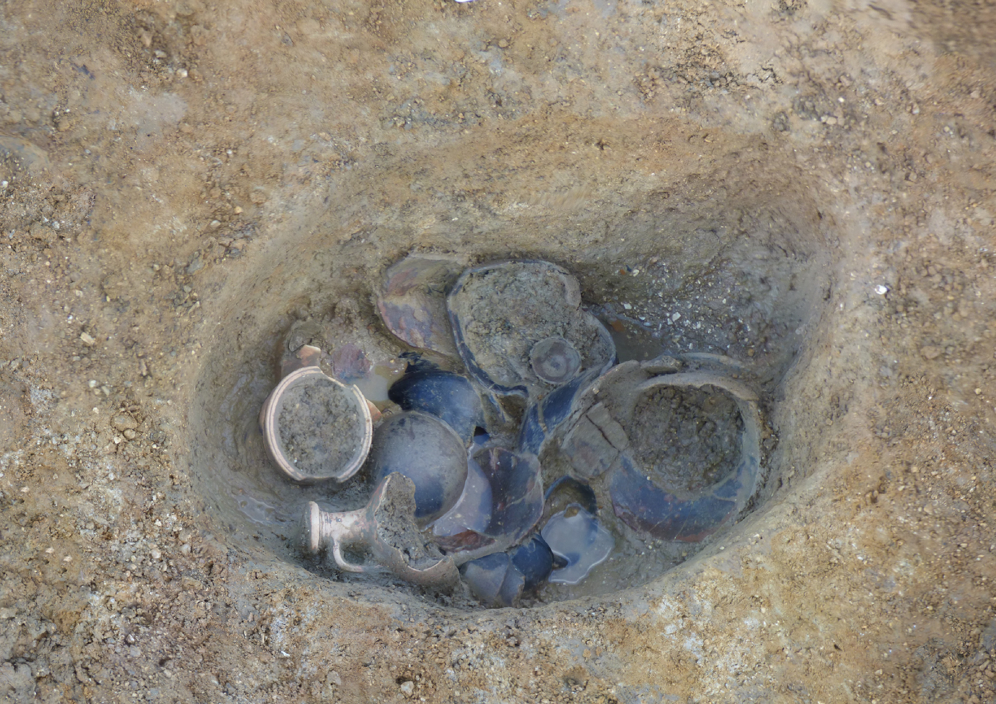
There are a number of other objects that may have been deliberately placed in certain contexts, perhaps connected with ideas of religious or spiritual belief. At Alconbury 4, for instance, a large, decorated late Roman shale pendant (F52036) was recovered from Waterhole 5.269, which could have been a votive deposit. More commonly identified as possible placed deposits was a series of complete pottery vessels in features at Bar Hill, Brampton West, Fenstanton Gravels and West of Ouse. At Fenstanton Gravels 4 a dozen complete or substantially complete vessels had been placed in the base of pit 781400 prior to backfilling (Fig. 4.48). A number of the vessels showed signs of use alongside evidence for holes pierced into the bases. The assemblage possibly represents the remains of a feast, although no food remains were found in association.
As previously noted (Settlement Development within the Roman Period), there was a contraction in the number of settlements in use across the A14 during the 4th century, though a few of these - notably River Great Ouse 2, Alconbury 4 and Conington 4 - seem to have been at their height during this time. These are also sites that appear to have had the greatest connections with the wider world and perhaps were the most integrated into surrounding socio-economic spheres. Such settlements may have played key roles in facilitating agricultural (and other) production and supply to the state, which in turn helped to bolster their elevated status. This may then explain why at two them at least there is little evidence for their continued use beyond the end of the 4th century, when many of the provincial social and economic structures rapidly broke down.
Nevertheless, there is limited evidence for possible continuity from the 4th into the 5th century at a few sites, including burials at Fenstanton Gravels and Conington with radiocarbon dates spanning this divide. This is explored further in Chapter 5.
Internet Archaeology is an open access journal based in the Department of Archaeology, University of York. Except where otherwise noted, content from this work may be used under the terms of the Creative Commons Attribution 3.0 (CC BY) Unported licence, which permits unrestricted use, distribution, and reproduction in any medium, provided that attribution to the author(s), the title of the work, the Internet Archaeology journal and the relevant URL/DOI are given.
Terms and Conditions | Legal Statements | Privacy Policy | Cookies Policy | Citing Internet Archaeology
Internet Archaeology content is preserved for the long term with the Archaeology Data Service (ROR). Help sustain and support open access publication by donating to our Open Access Archaeology Fund.
 Home
Home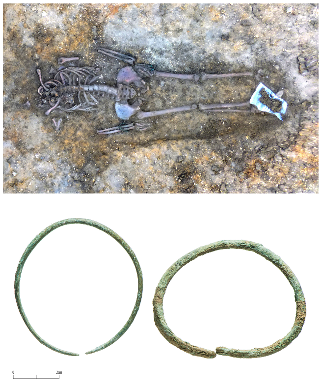