Mini journal logo  Home Summary Issue Contents

A Route Well Travelled. The archaeology of the A14 Huntingdon to Cambridge Road Improvement Scheme

Emma West, Claire Christie, Debora Moretti, Owain Scholma-Mason and Alex Smith

Illustrations by Beata Wieczorek-Oleksy, Marc Zubia Pons, Tom Watson, Eleanor Winter and Dunia Sinclair

Chapter 6: Villages and Farms. The medieval, post-medieval and modern periods of the A14 (AD 1066 to 1950) by Debora Moretti

Cite this as: West, E., Christie, C., Moretti, D, Scholma-Mason, O. and Smith, A. 2024 A Route Well Travelled. The Archaeology of the A14 Huntingdon to Cambridge Road Improvement Scheme, Internet Archaeology 67. https://doi.org/10.11141/ia.67.22

Introduction

The archaeological excavations undertaken during the A14 improvement scheme identified medieval and post-medieval remains across the whole project area, the most important of which was represented by the abandoned medieval village of Houghton and the 19th-century Grove Farm, both located within Brampton West Landscape Block (Fig. 6.1). Full details of the Brampton West excavation can be found within the Landscape Block report (West et al. 2024).

Figure 6.1 (interactive image): Location of the abandoned medieval village of Houghton and 19h-century Grove Farm at Brampton West in relation to the A14 scheme [Download image]

Brampton West showed, to a certain extent, archaeological and historical continuity between the Saxon and Norman periods visible through the spatial relationship between the different settlements (Brampton West Settlements 3, 4 and 5), but also between the settlements and their field systems. Unfortunately, it is not possible from the archaeological evidence to ascertain whether the settlement shift between the two periods was caused by an overall reorganisation at one specific time, a gradual shift over a longer period, or was caused by a change in the farming population or their status. Agricultural and semi-industrial activities continued in the area during the post-medieval and modern periods.

The A14 scheme offered the opportunity to gain an understanding of settlements, landscape and land-use changes between the Saxon, medieval, post-medieval and modern periods, as well as the opportunity to understand the transition between these periods. Most of all, it has offered the ability to excavate the southern section of the medieval settlement in its near entirety.

This chapter will focus on the archaeological results at Brampton West, their setting within the A14 archaeological programme and the wider historical backdrop of the period from 1066 to the 20th century. The later medieval and post-medieval evidence in the remaining A14 landscape blocks, mainly represented by evidence of agricultural activities such as ridge-and-furrow cultivation and field boundaries, is shown in Table 6.1.

Table 6.1: Medieval, post-medieval and modern agricultural evidence from across the A14 scheme
Landscape Block Medieval/Post-medieval evidence
Alconbury Medieval plough furrows
Agricultural building (post-med)
Brampton West Deserted village (medieval) (Settlement 5)
Medieval plough furrows (Field system 4; 102)
Medieval quarry pits
Post-medieval quarry pits
Post-medieval Grove Farm (Settlement 6)
Post-medieval brick kilns
Brampton South Medieval ridge and furrow
Post-medieval quarry pits
19th-century field system (1)
Post-medieval Trackway
West of Ouse Medieval plough furrows
Engraved medieval stone (SF15204) recovered from ridge and furrow
Post-medieval field boundary ditches
Post-medieval well
Modern boundary ditches
19th-century brick culvert
River Great Ouse Medieval open field system associated with Offord Cluny
Plough furrows
Two medieval Long Cross silver coins
Post-medieval parish boundary between Godmanchester and Offord Cluny (gone by 1926)
Post-medieval coins
Post-medieval and modern field enclosures (gone by 1926)
Fenstanton Gravels Medieval quarry pits
Medieval open-field systems
Medieval plough furrows
Medieval L-shaped ditch dividing the two field systems
Medieval green glazed pottery
Post-medieval waterhole/well
Post-medieval trackways (4 and 6)
Post-medieval enclosure
Post-medieval quarry pits
Post-medieval well
19th-century remains of a building
Conington Medieval plough furrows
Post-medieval double ditch boundary forming a potential trackway (Trackway 4)
Quarry pits
Bar Hill Post-medieval plough furrows
Post-medieval coffin handle and human bone fragments
20th-century building foundations (Rhadegund Buildings) (MCB25200)

Historical and Archaeological Background

Medieval period (1066-1500)

Historically speaking, the A14 scheme would have fallen within the two 20th century counties of Cambridgeshire and Huntingdonshire (the latter became a district of the former in the 1970s), although Huntingdonshire is the most relevant of the two. These two areas were first mentioned as separate geographical entities in the Anglo-Saxon Chronicles (late 9th century), where an entry stated that Huntingdon developed as a Saxon and Danish burh, favoured by its position on the lower ford over the River Great Ouse and along Ermine Street (Spoerry 2000, 37-39). Huntingdon prospered as a Danish military centre until Edward the Elder took it back from the Danes around AD 915, restoring and improving its fortification. A further section of the manuscript is dedicated to the Danish invasion of the south-east of England led by Thorskell the Tall in August 1009. After terrorising the east of the country in 1010, the Danish Army moved towards the west, but here '…Cambridgeshire firmly stood against them' whereas 'the East Anglians immediately fled' (Anglo-Saxon Chronicles, 1996 edn, 140). In Henry of Huntingdon's 'Historia Anglorum' (1080-1160) the two geographical entities are also described. In his Book 1 (chapter 5), where he describes the English counties and bishoprics, he stated that Cambridgeshire was the fifteenth county in the see of Ely whereas Huntingdonshire was, with others, subject to the see of Lincoln (Henry of Huntingdon Book 1:5 edn 1879). Despite the documentary evidence of the Saxon/Scandinavian period in this area, the archaeological evidence of this interface is practically non-existent here, as in some other parts of the country.

The aftermath of the Battle of Hastings (1066) and the succession of Duke William of Normandy to the English throne, saw several Saxon rebellions that arose from the discontent and resistance against the Norman conquerors across the country. One of the significant Saxon rebellions in Cambridgeshire was the Fenland Rebellion of 1071. The Fenland region, characterised by its marshy terrain, provided a natural stronghold for the rebels to mount resistance against the Normans. Hereward the Wake, a prominent Anglo-Saxon noble, emerged as a leader of this rebellion. He and his supporters carried out guerrilla warfare tactics from the Isle of Ely, launching attacks on Norman-held fortifications and estates. The siege of Ely (1070-1071) was perhaps the most remarkable event, which saw the Norman forces struggle to break through the natural marshy defences of the island. The Fenland Rebellion was not isolated, but it was part of a broader series of uprisings of which some were localised and short-lived while others lasted for years, continuing well into the following centuries, and ending ultimately with the displacement of the Anglo-Saxon ruling elite.

The Norman Conquest led to a profound transformation of the English socio-political landscape and saw the proliferation of fortification works across the country. These were characterised by castle construction probably to contain regional rebellions opposing Norman rule, but also the intensification of agricultural practices, the expansion of settlements, and the growth of towns.

The Great Anarchy of 1135-1154 represented a period of further political turmoil brought about by the rival claims to the throne of the Empress Matilda and King Stephen resulting in widespread chaos, civil unrest and socio-economic disruption. In Cambridgeshire, the personal rebellion of Geoffrey de Mandeville ultimately against both Matilda and Stephen caused further disruption. He sacked Cambridge, occupied Ely and from there plundered the fenland and fen edge communities, including Ramsey Abbey and St Ives (Creighton and Wright 2016), then using it as headquarters from where he carried on his plunder of the area, including Ramsey Abbey and St Ives. Despite this, the two counties flourished following that turmoil.

From the 11th to the 13th centuries, favoured by the medieval Warm Period (10th-13th centuries), England, like the rest of Europe, witnessed a period characterised by stability and economic growth that consequently saw rapid population growth. This, as well as the changes brought by the Norman Conquest, affected both Huntingdonshire and Cambridgeshire.

Not all Norman introductions benefited the population, and the implementation of the tallage (land use and tenure levied by kings), for example, caused much agitation. The people of Brampton and Houghton negotiated with the king, seeking protection from the increase in rents and services. When that was denied, they refused to pay and in 1242 and 1338 rebelled by recovering cattle seized by the authorities (Carpenter 2008).

During this period, the A14 scheme area was characterised by large swathes of agricultural land with intermittent villages and farmsteads, and with Cambridge and Huntingdon as well as St Ives and the port at Swavesey as the major centres of medieval settlement, trade, and industry. The economic expansion of Cambridge started with the corn trade and the grant by Henry I in 1131 (Roach 1959, 3). A further indication of the wealth of Cambridge was represented by the foundation of the university in 1209 and the foundation of churches by burgesses as well as the possible construction of St John's Hospital (c. 1200). By 1279, as stated in the Inquest carried out throughout the country by order of King Edward I, Cambridge had 17 parishes - three north of the river Cam and 14 south of the river - 17 churches, 76 shops or stalls, five granges, six granaries, three watermills, two windmills and a total of 535 messuages, an increase from the original 373 recorded in nine wards in 1086 (Rot. Hund. (Rec. Com.) ii, 356-40 cited in Roach 1959). The subsidiary roll of 1304 confirmed the continuous growth of Cambridge although by the mid-to-late 14th century and further during the 15th century, suggestions of economic stagnation and degradation started to appear in the form of the Black Death of 1349-1361, the Scottish and French War of 1318-1350, the Peasant Revolt of 1381, and two town fires in 1385.

Like Cambridge, by the 11th century, Huntingdon had become a significant settlement as stated in the Domesday Book entry of 1086 (Domesday Book, 1992 edition, 551). Excavations in Huntingdon have shown the expansion during the Saxon/Norman period (Mortimer 2007, 11-12; Mellor 2009) suggesting that urban occupation fully began in the 12th century and expanded with denser occupation in the 13th century. This period was characterised by open fields in the south-east, south of the Ouse Walk, and in the south-west at Mill Common. At Mill Common, 11th to 13th-century pottery production, gravel and clay extraction alongside agricultural activity within small burgage plots, was identified in recent A14-related excavations (Scholma-Mason et al. 2024).

Huntingdon, like Cambridge and the rest of England in this period, saw population growth and increased prosperity (Kenney 2003, 8). At this time, Huntingdon's status as a 'Shire' town, its position on the crossing of the river and along Ermine Street, and the tolls collected for travellers to the St Ives fair, one of the largest gatherings in the country, contributed to its success. The historical sources attributed to Huntingdon at this time 16 churches, two priories, a friary and three hospitals.

It was during this period that the process of early nucleation, which started in the middle Saxon period, came into full swing in the two counties. In the early medieval period, the village was not a 'settlement with a compact group of houses' as intended today, but either a 'nucleation of inhabitants in a single centre or a scatter of hamlets and farmsteads' (Dyer 1994, 408; Roberts and Wrathmell 2022). This was part of a wider expansion process that included a re-organisation of the landscape as much as the villages and hamlets. Non-nucleated villages were set in a more open landscape - such as woodland and pasture (Dyer 1994, 410) - and less rigidly controlled for the management of resources. Now, with more of a focused nucleation of the settlements came the expansion, re-organisation, and reclamation of more marginal areas and the use of different agricultural strategies to improve productivity, such as the introduction of manure (Jones 2012) and more intense management of animals (from free-grazing to enclosures) or perhaps more highly regulated use of common pastures.

Despite the lack of archaeological evidence, it is possible to assume that during this period, the largely un-nucleated hamlets and villages surrounding the A14 scheme became nucleated. The documentary and archaeological evidence are supported by the survival of medieval churches within the existing villages of Boxworth (CHER 00247), Lolworth (CHER 01283), Offord Cluny (CHER 02458) and Fen Drayton (CHER 14837) and by remains of medieval settlements identified during archaeological investigations within the core of modern villages and towns in this area (Fig. 6.2). Examples of these are the medieval pits, ditches, post-holes, ovens and gullies identified at Buckden (CHER 20274), Offord Cluny (CHER 15038) and Fen Drayton (CHER 20414).

Figure 6.2
Figure 6.2: Brampton West in relation to surrounding medieval to modern features

Documentary evidence and earthwork remains attest also to the evidence of at least five deserted 'shrunken' villages in this area: Boxworth (CHER 03528, 19346, 23144, 25512), Conington (CHER 25780, 25782, 25784), Fenstanton (CHER 25793, 25794), Lolworth (CHER 03500, 23129, 25514), and Houghton (CHER 11422). All of these, except for Brampton, comprise earthwork remains that have not been excavated. There were no earthwork remains for the deserted medieval village of Houghton (CHER 11422), and prior to the A14 excavations, this was only recorded on historic maps and documentary evidence (see below).

According to documentary evidence and earthwork remains, the area was also characterised by the existence of five moated manorial complexes at Boxworth (CHER 01088, 01089), Alconbury (CHER 00793), Fenstanton (CHER 01083, 11972), Lolworth (CHER 01090), Bar Hill (CHER 06127) as well as a medieval double-moated enclosure at Ellington (CHER 00773). Archaeological excavation at Fenstanton (Grove House) revealed two 10th to 11th-century pits within the moated enclosure, evidence for the infilling of the moat, and a 15th to 16th-century ploughsoil sealing the area (CHER 11972).

The use of the land throughout the medieval period was characterised by a mixture of arable and pastoral practices with, depending on the environment, more specialised activities such as wood pasture or pastoralism. In the area associated with the A14 mitigation, agriculture seemed to be the primary land use that was represented by field subdivisions, both as enclosures or field systems visible as earthworks, archaeological features, or referred to in documentary sources; trackways, drainage ditches and ridge and furrow. There was also evidence, albeit limited, of gravel or clay extractive activities on different landscape blocks, of the manufacturing industry such as blacksmithing, textile production and (possibly) brewing at Houghton, and pottery production at Mill Common in Huntingdon.

The Great Famine of 1315-1317/22 brought about by the beginning of the Little Ice Age, followed by the Black Death pandemic that took hold of Europe between 1346 and 1353 (Dyer 2010) slowed down these activities considerably. The succession of these two calamities caused a contraction in the economy and population growth that can also be seen in the archaeological record.

Documentary evidence dating to the 14th and 15th centuries suggests that during the 14th century, Huntingdon's decline began, starting with the demise of St Ives fair weakening the local economy, followed by a decrease of the population and the poor state of the local economy. By the mid-14th century, it seems only ten of the sixteen churches were still in use. By the 16th century, only St Mary's, All Saints, St Benedict's and St John's churches were still functioning (Clarke 2006, 6).

Documentary evidence of the same period suggests the same fate for Cambridge with evidence of economic stagnation starting in the mid-to-late 14th century, which was followed by the abandonment of dwellings and closure of churches such as the Church of St John Zachary and the Church of All Saints by the Castle after the Black Death. In 1446 a petition filed by the burgesses lamented a further loss of population and trade. This was attributed to the encroachment of colleges on businesses, but it was exacerbated by the state of the economy across the country at the time (Roach 1959, 110).

Post-medieval to modern (1500-1950)

Much of the A14 area remained agricultural throughout the post-medieval and modern periods. The evolution of farming practices and the process of Enclosure saw a change in the field systems with a forced move from the communal open fields to a more divided landscape, which is reflected both in the landscape today and in the archaeological record. Although finalised in the 18th century with parliamentary enclosure, this process was started in c. 1500 and was affirmed by the 17th century (Wordie 1983). From the very first parliamentary Enclosure Act in 1604, specifically applied to Radipole in Dorset, to the last 20th-century award, a total of 6,436,188 acres were enclosed in England and Wales. Although the 1760 enclosure act was the one historically considered the most important, it was estimated that between 1604 and 1760, at least 228 Enclosure Acts were passed (Wordie 1983, 486), enclosing approximately 358,241 acres of land. By 1607, approximately 5.25% of the land in Cambridgeshire and Huntingdonshire was enclosed (Gay 1903; Johnson 1963; Wordie 1983, 491). The conversion of agricultural open land into sheep management enclosures hit Cambridgeshire and Huntingdonshire less than other counties. In Warwickshire between 1450 and 1485, for example, 72 settlements were abandoned, owing to the conversion of agricultural land to sheep pastoralism (Beresford 1951, 133). The enclosure of open land for more focused farming at the end of the 16th century also occurred in Cambridgeshire and Huntingdonshire but, as previously, less so than in other counties (Beresford 1951, 144).

Cambridgeshire and Huntingdonshire were not major battlegrounds during the Civil War but felt the consequences heavily. The war brought considerable disruption to the economy. Armies marching through the counties often requisitioned supplies, leading to scarcity and inflation and many areas were devastated by the constant movement of the armies, looting and destruction of properties. Agricultural activities as well as trade were severely affected, leading to food shortages and economic hardships for the local population.

Cambridgeshire contributed soldiers to both the Royalist and Parliamentarian armies with the conscription of local men, many of whom never returned home. This loss of manpower had long-term consequences for the county's workforce and communities. Cambridge was a site of strategic importance during the war and in 1643 was besieged by Parliamentarian forces who sought to control the university town, castle, and its defences (Roach 1959, 15-29).

Huntingdon, Oliver Cromwell's hometown, like Cambridge, was of strategic importance owing to its position and was involved in a brief but significant siege in 1645 (Hutton 2021, 8-13). The Royalist garrison held the town but ultimately surrendered to the Parliamentarians and the skirmishes between the two sides brought damage to the town's defences and buildings. The Civil War created divisions among the people of Cambridgeshire and Huntingdonshire, with some supporting the Royalist cause and others siding with Parliament (Hutton 2021, 79). After the Parliamentarian victory, local governance structures were reorganised, and individuals who supported the Royalists faced penalties and confiscation of properties, damaging the economy further.

After the war, the restoration of the monarchy in 1660 marked the end of the Commonwealth period and brought relative stability to the region. The effects of the war, however, lingered and it took time for both counties to recover economically and socially.

It was from the end of the 17th century that the economy started to recover in both regions. Agriculture remained the dominant economic activity supported by a thriving wool trade, moderate textile manufacturing and milling. The River Great Ouse facilitated river transportation, contributing to Huntingdon's economy. The major market towns of Cambridge, Ely and Wisbech, a port town, played a crucial role in facilitating trade in the region as well. The continued efforts to drain and reclaim the Fenlands of Cambridgeshire made previously marshy lands suitable for agriculture, further boosting the region's agricultural output (Hutton 2021, 8 and 9). It is during this period that larger houses, gardens, and parks were created within some of the settlements across the area, namely Alconbury Park, Brampton Park, Buckden Little Park, Conington Hall and Park, Boxworth House, Lolworth Grange and Girton College.

The late 18th and 19th centuries saw the advent of the Industrial Revolution and, although the two counties were not major industrial centres, the region saw an expansion in textile, milling and engineering activities. The region was characterised by infrastructure improvements as well, such as the expansion of railways and roads, connecting the counties to the national transportation network (Balchin and Filby 2001; Moretti 2022). As seen below, the Great North Road played an important role in the history of Houghton.

During the 20th century, both counties played a significant role during World Wars I and II hosting military bases, airfields, and training facilities such as at Mill Common in Huntingdon (Moretti et al. 2023) contributing to the war effort. Some evidence for features associated with the two World Wars is recorded in this area, including pillboxes in Brampton Hut (CHER 15210), Fen Drayton (CHER 15203), Girton (CHER 10397) and a Royal Observer Corps Post in Buckden (CHER 16436). RAF Brampton was a base from the First World War until relatively recently.

Archaeological evidence for other, more general, post-medieval activity has been identified in the area, including brickworks at Boxworth (CHER 25510); earlier farm buildings at Whitwell Farm in Offord Cluny (CHER 24112); and gravel pits in Conington (CHER 25788), Offord Cluny (CHER 15038), Girton (CHER 18274, 19899), and Fen Drayton (CHER 20969, 25812).

Medieval Archaeology of the A14

Evidence of medieval agriculture activities was present across all eight landscape blocks of the A14 mitigation. These were mainly remains of field systems, boundary ditches, fence post-holes, wells, and ponds (see Table 6.1).

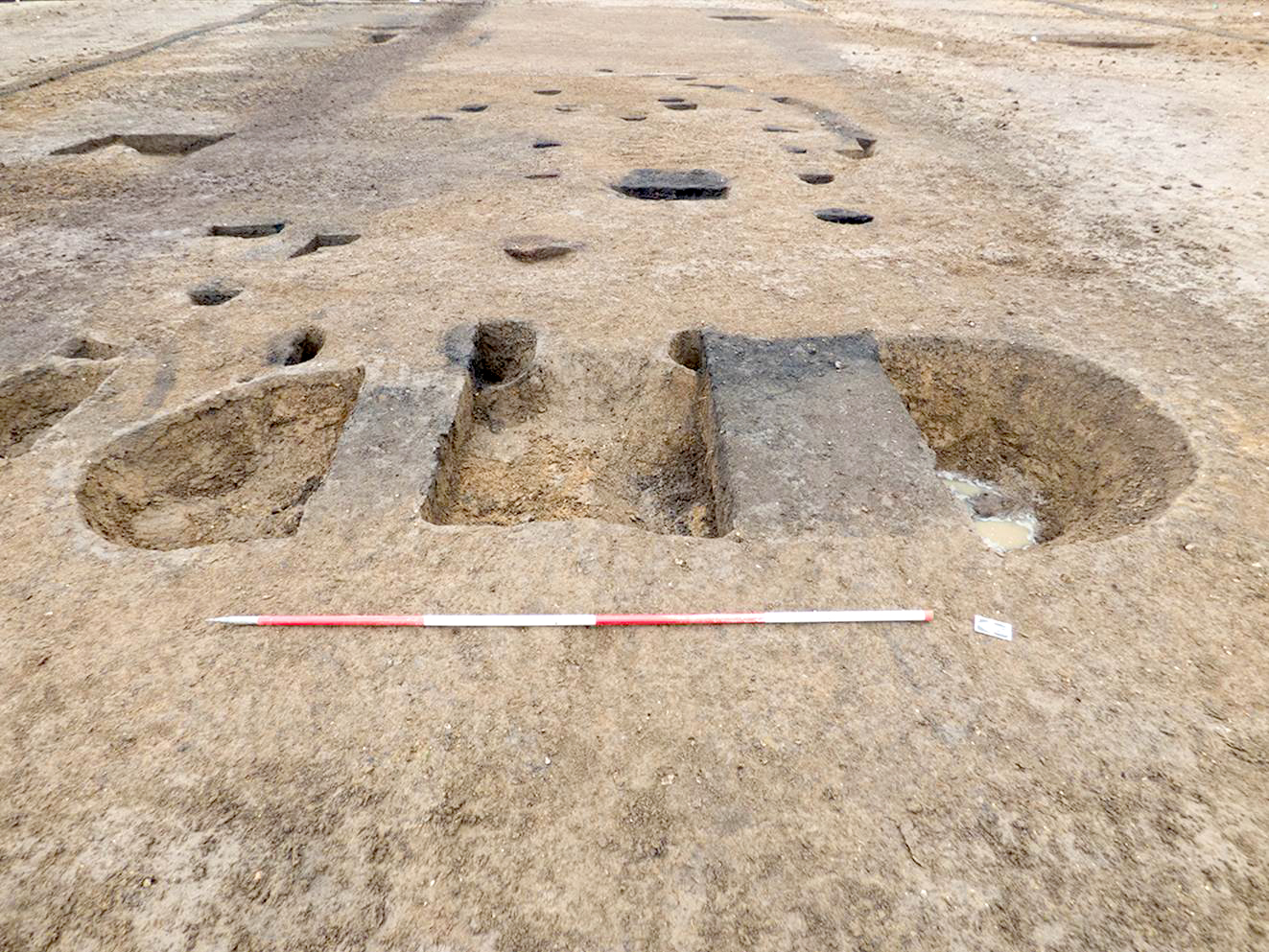
Seven landscape blocks - Alconbury, Brampton South, Brampton West, Fenstanton Gravels, West of Ouse, River Great Ouse and Conington - presented different alignments of medieval plough furrows suggesting different periods of farming or subdivision of the areas by separate fields or furlongs. At West of Ouse (TEA 16) the medieval ridge-and-furrow earthworks did not extend over the barrow, as it was - then and at the time of excavation - still visible as a slight upstanding earthwork. The barrow itself seemed to delimit the extent of the medieval cultivation as no furrows were identified in the area to the east, towards the river. Brampton West provided the most extensive medieval evidence with the remains of part of the hamlet of Houghton (Fig. 6.3).

Introduction to the Houghton hamlet

Settlement Brampton West 5 (BW5), historically known as the village or hamlet of Houghton, was established before the Norman Conquest and appears from the archaeological records to have been partially abandoned by the end of the 13th century, with a smaller scale return to the settlement in the mid-14th to early 15th centuries before the settlement was entirely abandoned. This diverges from the historical records, which indicate instead a continuous occupation throughout the 13h and 14th centuries.

Figure 6.3
Figure 6.3: All excavated medieval to modern features at Brampton West

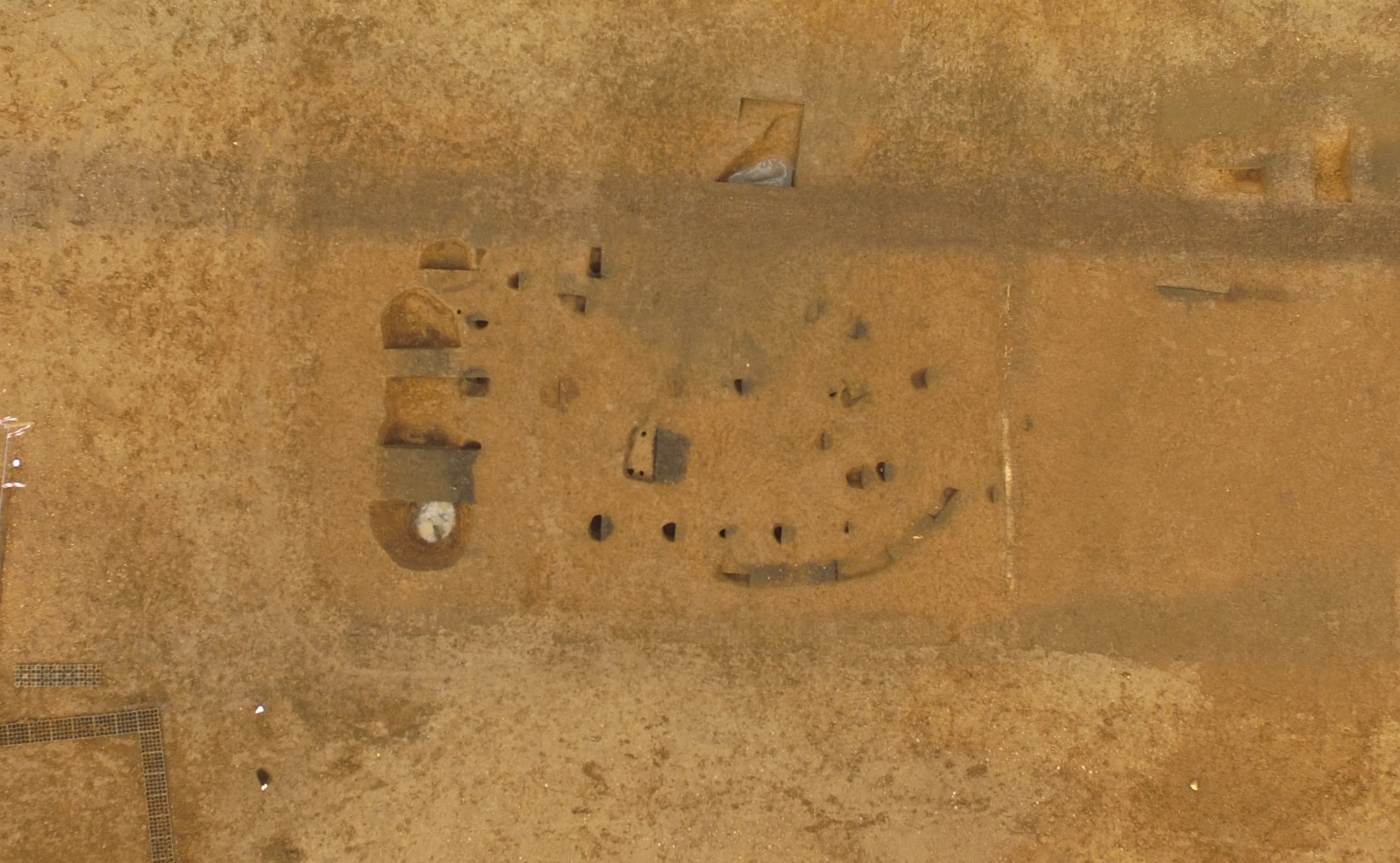
The archaeological remains of Houghton were uncovered around the northern, western, and southern edges of TEA 7C, surrounding an open area within the centre of the excavation area where settlement BW3 (Chapter 5) had been located. The total exposed area was approximately 10ha (Fig. 6.4). The settlement did not continue east but is likely to have extended to the north of the A14 scheme area (CHER 11422). An earthwork visible on Google Earth imagery as a line of trees aligned NNW-SSE before turning north-east to the north of TEA 7C may represent the north-western corner of the settlement (Fig. 6.5). Further evidence of the edge of the settlement is represented by the south-western copse of trees between TEAs 7A and 7C.

Figure 6.4
Figure 6.4: All medieval phases of the excavated settlement at Houghton (BW5)

Houghton probably developed as an outlier (or daughter settlement) to the main medieval settlement of Brampton, as it had no church or manor house. This identified its character as a 'hamlet' (rather than a village), which developed on the western edge of the territory of Brampton, c. 250m to the east and north-east of Brampton and Harthay Woods and 200m to the west of the Great North Road (West et al. 2024, 207) (Fig. 6.5). The proximity of Houghton to both Brampton and Harthay Woods, as well as the Great North Road, likely influenced the development of this hamlet. A blacksmith's workshop identified within the settlement might have catered for the travellers along the Great North Road and the people coppicing and pollarding the nearby wood. Its position on the higher ground may have facilitated its visibility and access from the road. The area surrounding Houghton was utilised for arable agriculture and was represented by Field System 4 to the east and the furrows recorded across the rest of the landscape block (Field System 102).

Figure 6.5
Figure 6.5: The settlement at Houghton (BW5) in local context

Professor Christopher Dyer provided the documentary evidence on Houghton discussed in the following paragraphs (see also West et al. 2024).

The place-name, Houghton, assumed to be of pre-conquest origin, indicates a settlement by a hill spur. The conjectured date for its adoption is possibly the 8th century (Gelling 1984, 167-9) and perhaps refers to the Saxon settlement BW3. The place-name persisted and was maintained throughout the settlement changes, but it appears to have been changed to Woodhoughton by the 13th century, as officials needed to distinguish between Houghton in Brampton and the larger village of Houghton near St Ives, clearly marking its connection to the nearby Brampton Wood. Houghton's location within a road network already established in the 11th century might have been beneficial for its economy.

The earliest documentary evidence of Houghton as a separate settlement from Brampton is dated to 1279 when juries reported to a royal survey about tenants and their holdings in each village, the first enquiry of this kind since Domesday. Only fragments of the resulting Hundred Rolls survive, but they include a complete coverage of Huntingdonshire. The list of tenants at Houghton was a subdivision of the survey of Brampton but clearly distinguished from the main village. There were 34 tenants, of whom 20 held messuages (houses and associated buildings) and were likely to have been inhabitants. Their lands amounted to 240 acres of arable and 37 acres of meadow. No details are given of pasture, as this would have been a share of grazing on commons, which could not be expressed as an acreage (Illingworth 1812-18, 607-10).

One hamlet, two stories: documentary sources vs archaeological evidence

The archaeological evidence appears to indicate that Houghton reached its peak in the mid-13th century followed by a steady decline, reaching a low level of activity in the early 14th century. The archaeological evidence also showed a small-scale revival at the end of the 14th century and into the early 15th century, which was then followed by total abandonment.

The documentary evidence, however, seems to depict a well-populated settlement in 1279, with no hint of decline. Furthermore, the Houghton tax-payers list of 1327 indicated a total of 46 tax-payers. Nine of these had surnames found in the survey of Houghton made half a century earlier (Raftis and Hogan 1976, 213-14), indicating continuity in the family ties of Houghton. This continuity appears also in the court roll of 1350, which not only mentioned one of the 1338 rebels from Houghton but also lists at least seven people from Houghton taking part in the 1338 rebellion and, as in the tax list of 1327, some of the surnames were also found in the hamlet in 1279 (Hunts Archives, Box 4/3A). Dyer (in West et al. 2024) suggests that if seven names were listed among the rebels, an equal or larger number of names did not take part in the rebellion. This would push the numbers to 14 to 20 heads of households at Houghton in 1338, at the time when archaeologically the settlement appears 'abandoned'. This would constitute a rather large hamlet considering that the typical size was between 5 and 10 households, with 30 households in Wharram Percy at its peak in the 14th century (Beresford and Hurst 1990). Although it is difficult to establish the average size of a medieval family in England, a 3.5 average size per family has been postulated here (Krause 1957). This would give a presumed total of 49 to 70 people residing in Houghton in 1338.

So why are there these discrepancies between the documentary sources, suggesting a survival of the settlement throughout the 13th and 14th centuries, and the Bayesian modelling and the archaeological evidence (finds and features) suggesting a decline of the settlement at that time, until its eventual abandonment in the mid-15th century? Why does Houghton have two different stories? One possible reason for the discrepancies is that the archaeological investigation only identified part of the original hamlet and that further remains of structures and tofts, possibly later in date, exist beyond the excavation limits.

It is possible that after the famine, climatic downturn, and subsequent diminishing resources from 1315, the inhabitants of Houghton felt the restraints and adopted a stricter domestic economy. This would have been characterised by less wastage not only in food and drink but also on household items such as pottery or metal objects (the archaeological evidence of this would be the survival of older pottery typologies and limited metal finds), and with a more 'spartan' approach to building maintenance. The pottery assemblage from Houghton, typical for a rural settlement, included pottery typologies such as unglazed St Neots, with smaller quantities of glazed Stamford ware and Lyveden-Stanion ware, characterised by a long 'lifespan' and as such supporting the possibility of longer but less visible activity at Houghton.

It is possible, therefore, that where these elements have been interpreted as a slow abandonment of the hamlet, they perhaps indicate economic contraction or deterioration that does not imply abandonment.

They could also indicate settlement drift, where the village drifted outside the excavation area. Equally it could mean a change in construction techniques from earth-fast construction to ground-set timbers (see Houghton's structures). If the later structures did not break ground they may be entirely invisible archaeologically. It is possible that despite the fact that the inhabitants of the excavated part of Houghton became more invisible in the archaeological record, they were still there throughout the 13th and 14th centuries.

Moreover, it is conceivable that the economy of Houghton relied more heavily on Harthay and Brampton Woods than previously assumed. The comparative analysis of the remains of houses, when juxtaposed with similar sites such as West Cotton in Northamptonshire or Wharram Percy in Yorkshire, reveals more indications of poverty and economic deterioration at Houghton. This observation is further supported by the limited range and quality of artefacts and the predominantly domestic nature of the pottery discovered. Two possible explanations for these circumstances are an economy predicated on either the volatile demand for woodland products or the enforcement of increasingly stringent Forest Laws. The latter would result in the loss of communal rights to the woodland or the deforestation of sections within Harthay and Brampton Woods, subsequently leading to their clearance for agricultural purposes (assarting).

Between two periods: the transition phase

The transition between the Saxon and Norman periods has been, historically, a challenging subject ranging from the idea of a 'cataclysmic event' characterised by a total reshaping of the English landscape and culture by 'Norman import' such as castles, cathedrals, and monastic churches, to the more recent idea of a 'nuanced albeit still perceptible change within an already vibrant and diverse cultural background characterised by European, Scandinavian and pan-regional influences already in place before 1066' (Liddiard 2017, 105-6).

In order to assess the possible changes brought on by the Norman Conquest in England, these changes have to be separated from those brought on by wider shifts in society not associated with the Norman Conquest. These changes, such as the population growth which saw a peak in the mid-to-late 12th century across Europe, in turn brought on further changes. These were represented by the expansion of arable and assarting land, bringing woodland and wood pasture under threat and the privatisation of these for the benefit of the barons and lords, with the push of emparking as seen across Europe in the two centuries after AD 1000 (Liddiard 2017, 116). Furthermore, these changes can also be seen in the more frequent construction of high-status structures, the development of Forest law (Liddiard 2017, 116), and settlement planning.

Historically speaking, closely dating archaeological evidence from villages, hamlets, and farms immediately before and after the Norman Conquest has been difficult. This has rendered the original categorisation of 'nucleated' village pattern versus the 'dispersed' hamlet and farm patterns a highly debated topic. Despite this debate, both documentary and archaeological records show the clear development of 'nucleated' villages by 1200 - at least in the 'midland shires' (Liddiard 2017, 120). The concept, however, that the development of a nucleated and regular village was the result of a precise event either by the lords or the communities to restructure the planning of the village is now considered obsolete. The expansion of archaeological knowledge is increasingly supporting the idea that the nucleated village happened as 'a consequence of the reorganisation of the settlement's attendant field system and the expansion of house plots over nearby land' (Williamson et al. 2013, 81-7). This has been observed in some cases in Northamptonshire where the re-examining of the idea of 'nucleation of a formerly dispersed pattern of settlement during the middle or late Saxon period … resulted to be more a myth than a reality' (Williamson et al. 2013, 81 and 87).

Further, the idea that 'the Normans were so good at assimilating that they assimilated themselves out of existence' (Fernie 2000, 303) might explain to a certain extent the paucity of archaeological evidence regarding the possible changes brought by the Norman Conquest in the development of pre-conquest settlements and hamlets. Specifically, the concept that these changes did not actually take place but rather that there was a development of the original settlement and settlement location over centuries, as seen at Brampton West. Here, from an open scattered settlement characterised by SFBs and some post-built structures - some of them as early as the 5th century - and a middle-Saxon settlement (BW3) characterised mainly by post-built structures arranged in a semi-organised layout, the settlement landscape developed further in the late Saxon and medieval period. Approximately 180m to the south-east of BW3, a separate late Saxon enclosed settlement (BW4) and associated field system developed between the 10th and 12th centuries, whereas the larger and longer-lived medieval settlement (BW5) was located immediately to the west of BW3, with buildings organised along a road (see Chapter 5 for details of Saxon settlements). This developed into the medieval settlement of Houghton, indicating perhaps the movement of the population from the settlement (BW3) across into BW5/Houghton.

The period of transition between the Saxon and the Norman periods at Brampton West was represented by settlement BW4 in the south-eastern corner of TEA 7BC, as seen in the previous chapter. Dating evidence from the pottery and radiocarbon samples indicates that BW4 was abandoned in the 12th century, with little evidence for any continuity into the 13th century or beyond, apart from two boundary ditches (Ditches 7BC.111 and 7BC.59). Ditch 7BC.59 may have continued as a north-east to south-west aligned ditch shown on the 1772 Inclosure Plan (see Fig. 6.19). According to Stuart Wrathmell (pers. comm), the short-lived character of settlement BW4 could be an indication that this was a short-lived demesne farm created by the King's administrators at Brampton.

Evidence for this transition period can also be seen in the layout of BW5 and Field System 4, which appeared to respect (as an open area or village green) the area where BW3 was originally located (Fig. 6.4). This 'village green' may represent an area kept as permanent pasture, as seen in other medieval villages in eastern England and East Anglia, or it could indicate an area used as a cultivated open field, as seen for example at Whittlesford (Cambridgeshire) and Stanfield (Norfolk) (Roberts and Wrathmell 2002, 109). Many greens in the southern part of Cambridgeshire are thought to date to the early or middle Saxon period (Taylor 2002; Oosthuizen 1993; 2006, 51-9); however, in this case, the 'green' element is clearly later.

In addition to this, the archaeological evidence and the Bayesian modelling (see Table 5.2 in Chapter 5) indicate a potential crossover between settlements BW3 and BW5/Houghton. Specifically, two post-built structures and pits identified in BW3 (see Chapter 5) presented a late Saxon date, whereas some structures identified in BW5/Houghton (see below) returned a pre-conquest date, indicating the co-existence of the two settlements in the 10th century.

Earliest archaeological evidence

The initial phase of the settlement, dating to the late 10th and 11th centuries, was identified in the northern and western areas of TEA 7C (Fig. 6.6). This phase comprised various components, including the earlier phase of a north-east to south-west aligned northern street (Trackway 1), eleven structures, three pit groups (some displaying signs of burning), quarrying operations, a kiln, and an oven. Radiocarbon dating results suggest that certain elements of this phase pre-date the Norman Conquest, with no temporal gap between the latest stage of BW3 (cal AD 990-1150) and Houghton's earliest phase (cal AD 880-1000 - BW 3 (Structure 7BC.265, SUERC-91421); Settlement 5 (Structure 7BC.509, SUERC-91422).

Figure 6.6
Figure 6.6: Late Saxon-early medieval phase of the Houghton (BW5) settlement

The northern street (Trackway 1), of which approximately 80m in length was identified, constituted the principal feature in the northern section of the settlement. Pottery findings from the ditches defining this street consistently yielded dates from the 11th century.

Four of the structures identified and associated with this phase were situated to the south of the street, three to the north and five to the west. The four structures positioned south of the street were intentionally arranged parallel to and along its southern edge. It is plausible that some of these structures continued to be used in Phase 2. The dating evidence primarily pointed to the 11th-century period, with a few pottery fragments from the mid-13th century.

Structure 7BC.529, located to the north of Trackway 1 (Fig. 6.7), represented the most distinct among the three buildings in that vicinity. This rectangular building featured external post-holes, larger posts on its north-western side, internal divisions delineated by rows of posts, and scattered internal post-holes. The pottery assemblage recovered from this structure predominantly dated to the mid-11th century. Radiocarbon dating indicated that it was constructed during the pre-Conquest era, potentially slightly later than Structures 7BC.506 and 7BC.509. As well as food production, this structure yielded a considerable quantity of cereal grains as well as flax seeds (González Carretero 2024). These might suggest a possible involvement in linen production. Some of the pits to the south-east of the structure (Pit Group 7BC.531), arranged in pairs on a line 10m long, contained frequent charcoal, fired clay, and abundant plant remains. This suggests that they may have functioned as simple corndryers, perhaps later used as refuse pits. Alternative uses of the pits might include fire-pits, or housing circular wooden tubs for processing products.

Figure 6.7
Figure 6.7: Plan of Structure 7BC.529

The two structures to the west (7BC.470 and 7BC.490) lacked any discernible arrangement and their size and layout remain unclear. The pottery findings from these structures dated to the mid-11th century. Radiocarbon dating corroborated the classification of these structures as part of Phase 1. The purpose of these structures remains unknown, although some may have served as dwellings, while others might have functioned as barns and agricultural buildings or workshops associated with quarrying activities. There is no evidence of a field system or land division linked to this early phase.

Main development: second phase

The subsequent phase of the settlement, in the 12th and 13th centuries, witnessed the formalisation of the hamlet's layout (Fig. 6.8). This phase involved the establishment of primary streets (Trackways 2 and 3) and a secondary street (Trackway 4), as well as boundaries demarcating the settlement from the central open field (Linear Boundaries 5 and 6) and various plot boundaries. Excavated features within the settlement comprised buildings, pits, wells, ovens and industrial pits. This phase represents the most intensive period of activity within the settlement.

Figure 6.8
Figure 6.8: High medieval (12th/13th century) phase of the Houghton (BW5) settlement

The settlement was delineated by its streets (north, west and south) with the north one (Trackway 2) serving as the primary route through the northern and western areas, the south street (Trackway 3) traversing the southern part, and the west street (Trackway 4) branching off from the north street, possibly leading towards Brampton Wood (Table 6.2). These streets were developed in the 12th century and played a central role in organising settlement activities. The north and south streets remained in use during the later medieval periods and even into the post-medieval era, likely serving as agricultural routes.

Table 6.2: Houghton streets (Trackways 2, 3 and 4)
Trackway/Street Dimensions Direction
(L x W)
Composition Dating
2 440m x 5m to 16m NE-SW and S Holloway form in the north and south 12th to 13th century (with some 11th and 14th century pottery)
Raised metalled surface in the west
3 250m x ? NE-SW Parallel Intercutting ditches 12th century
4 21m x 10m NE-SW Parallel ditches and partial metalling

Evidence from the 1772 Inclosure Map (see Fig. 6.19) and the curvature of ditches in the north-east indicates that the north street (Trackway 2) likely curved northward, potentially preceding the enduring north-south track. The north street (Trackway 2) intersected the south street (Trackway 3) in the southern part of the settlement. In this map, the north street appears to continue as a lane around what became known as Rev. Taylor's Glebe Land and out further west towards Brampton West. This is a parcel of land, which, corresponding to the location of the HER points for the abandoned medieval village of Houghton, might be where further remains of Houghton could be located. Further, on the east side of this land parcel, the north road appears to have a junction with a track towards what became, in 1663, the Great North Road.

Although the physical connection between the north and south streets was not observed, both streets were established concurrently and served as prominent features and potential boundaries within the Houghton settlement. The south street (Trackway 3) likely extended south-west beyond its junction with the north street (Trackway 2), forming a 'T-junction' and linking Houghton to Brampton Wood. The west street (Trackway 4), located in the western part of the settlement and aligned approximately east to west, may have continued south-west towards Brampton Wood. Its absence from later historic maps suggests that the west street ceased to be used by that time.

The settlement's boundaries were defined by two primary ditched features (Table 6.3). Linear Boundary 6 acted as the north-eastern boundary, separating Houghton from the central area previously occupied by settlement BW3. Linear Boundary 5 served as the hamlet's southern boundary. These boundaries were established during the formalisation of Phase 2 in Houghton, reflecting efforts to demarcate and organise the settlement. The existence of other boundaries beyond the excavated area remains uncertain, although the 1772 Inclosure Map (see Fig. 6.19) implies that the south street (Trackway 3) may have also functioned as the effective southern boundary of the settlement.

Table 6.3: Linear boundaries
Linear Boundary Dimensions
L x W x D
Direction Composition Dating
5 270m x 2/2.5m x 0.5/1.1m NE-SW and W Ditch 7BC.345 12th and 13th centuries
Ditch 7BC.346
6 275m x 0.35/0.85m x 0.05/0.2m NE-SW Ditch7BC.541
Ditch 7BC.542
Ditch 7BC.543
Ditch 7BC.544
Ditch 7BC.545

The 1772 Inclosure Map shows that Linear Boundary 5 persisted as a delineation for an agricultural plot of land into the post-medieval era. However, it had been removed by the time of the 1808 Ordnance Surveyors drawings and was later truncated by the 19th-century Brick Kiln 7BC.344. Linear Boundary 6 ended just before the north street (Trackway 2) in the west, possibly serving as an entrance into the hamlet. It was not observed to the east beyond the modern trackway. Three gaps were found between its ditches, likely serving as access points between the settlement and the fields. Some sections of the boundary had post-holes, suggesting the presence of a fence, while others were irregular, possibly indicating a hedge-line. The purpose of this boundary was probably to separate the settlement from the surrounding fields.

In the northern and western parts of Houghton, activity was concentrated north and west of the north street. Its northern side exhibited a more organised layout, featuring north-west to south-east aligned plot boundaries dividing the area into smaller plots. Structures and pit groups were found in this area. On the other hand, the southern side had fewer structures and no evidence of plot divisions, with the smithy and associated pits present. It is possible that the southern area was used for 'industry' while the domestic occupation was focused on the northern side. The western part of the area consisted mainly of pit clusters, indicating extraction or industrial activity, and included one significant L-shaped boundary and one structure. Some of the pits contained dark burnt clay-silt fills with frequent charcoal inclusions representing the dumping of burnt material. The environmental evidence indicates the presence of mainly wild seeds from arable grasses (suggesting that the burnt material did not derive directly from woodland crafts such as ash burning or soap boiling).

In the southern part of Houghton, the main activity was associated with the south street (Trackway 3) and Linear Boundary 5. Unlike the northern and western parts, there was no evidence of occupation beyond the 13th century. Here, only domestic activity was identified, with plot divisions following different orientations as well as several structures. This part of the hamlet had four post-built structures and one structure characterised by beam-slots. The structures were sub-rectangular in shape and varied in size between 10m by 8.5m and 18m by 8.5m. Additionally, there was a well and two pit clusters serving this area.

The activity in the northern and western parts of Houghton during the 12th and 13th centuries was a continuation of the earlier phase, particularly along the western side, whereas in the south the activity appears to belong only to Phase 2. The character of activity was similar, but more formalised, especially along the northern side, with the construction of the north street (Trackway 2), Linear Boundary 6, and plot divisions.

A total of eight buildings from the 12th and 13th centuries were identified in the northern and western parts of Houghton, primarily located to the north and west of Trackway 2. Building 7BC.546 was the only one with a clearly identifiable ground plan. These buildings included groups of post-holes, beam-slots and a combination of both.

Two special buildings

Structure 7BC.513, to the north of the north street (Trackway 2), was different in construction from the other buildings in Houghton (Fig. 6.9). It comprised an area of stone bedding measuring 5.2m by 1.4m by 0.18m deep, with a stone-filled post-pad 0.7m to the north-west, and three other post-holes around the stone area. Pottery dating was mixed but included 76 sherds of late Saxon, 11th century, and mid-13th century date - representing the highest concentration of pottery recovered from any of the structures in the settlement. This was all covered by Deposit 7BC.514, which may have been a preparation area for a later building (see discussion below). This structure was also the only building within the settlement of Houghton with significant quantities of animal bone (Faine 2024b). This, combined with the different character of the structure, suggests that it may have had another function from others in the settlement, potentially for the processing of animal remains. Maybe, situated so close to the north street (Trackway 2), this represented not only a butcher's shop servicing the settlement but also providing services for the travellers along the Great North Road and the east-to-west road.

Figure 6.9: Photo of Structure 7BC.513
Figure 6.10: Plan of Structure 7BC.546 (smithy)
Figure 6.11: Photo of Structure 7BC.546 (smithy)
Figure 6.12: Drone photo of medieval smithy under excavation. Scroll to browse and click to expand.

Structure 7BC.546 was a clearly defined smithy located south of the north street (Figs 6.10-6.12). It had a sub-rectangular shape, measuring 8.7m long by 3.8m wide, with a truncated northern side owing to a post-medieval land drain. The structure consisted of 16 outer post-holes, a beam-slot along the south-eastern edge, and four post-holes potentially forming a covered entrance or small annexe. Replacement of external post-holes indicated maintenance. Inside the structure, three post-holes divided it into two areas, and a sub-circular shallow pit in the centre could represent the remnants of a hearth, surrounded by five stake-holes possibly used to support bellows. Examples from the same period indicate that the hearth was most likely a waist-height structure.

Pit Cluster 7BC.337, located south-west of the smithy, was a cluster of sub-rectangular pits covering a 4.4m by 1.5m area. These pits, approximately 0.7m deep, contained three fills, including lower silty-clay formed through natural infilling and two dark silty-clay fills with charcoal, fired clay, and slag as deliberate backfills. These pits likely served also as waste disposal for metalworking.

The smithy yielded significant amounts of iron-working slag, including 1444g from the central hearth and 1044g from an external post-hole. Smithing hearth bottoms, hammerscale, and possible bloom fragments were among these remains, suggesting smithing and smelting activity. Other finds included a small quantity of pottery, animal bone, and ceramic building material. Oak charcoal from one of the post-holes was radiocarbon dated to cal AD 660-780, but it was attributed to the 'old wood' effect rather than the structure being of Saxon origin. Metal items such as horseshoes, horseshoe nails, locks, and keys, indicative of medieval smithing activity, were found across the site.

The archaeological remains of the smithy provide insights into its subdivision and spatial functionality. Its location, in the north-eastern edge of the hamlet but near the main street, is typical of the time owing to the danger of pollution and fire yet easy accessibility from the main access road (Franklin 2020, 142). It is possible that the entrance was on the north-western side or north-eastern end facing the north street (Trackway 2). Post-holes of sub-group 6, traditionally interpreted as a small annexe, could represent a covered or enclosed pre-working area facing the north street, perhaps designed to facilitate work on horses and carts. Inside the smithy, two distinct areas demarcated by post-holes of sub-group 4 likely constituted the main working area, with the forge located near the centre. The post-hole of sub-group 5, presenting stone padding, may have held the anvil block as did the one identified at the South Witham smithy (Mayes 2002, 37). Its position, close to the south-western wall, follows the spatial arrangement of later smithies (Light 1984; 1987; 2007; Fleming 1986; Killick and Fenn 2012).

These smithies had the anvil a few steps away from the forge, near windows or openings for better visibility and light during the shaping and hammering of heated metal.

The separate northern section of the smithy may have served as a domestic space for the smiths and their families, or a shop front for customers or storage for iron stock. The beam-slot along the south-eastern edge initially thought to be a wind-screen, could also be the remains of a lean-to shed used for storing fuel outside the smithy, to mitigate the fire risk of storing it within the forge itself.

The 14th century: third phase

By the late 13th century, most of the excavated area of Houghton appeared to be abandoned - from an archaeological point of view. A small area in the northern part, however, showed signs of activity in the mid-14th century. This area, approximately 0.40ha in size, revealed possible structures, pit groups, and a large ditch.

Although no definite 14th-century structures were identified, Deposit 7BC.514 and Pit 730381 suggest the presence of sparse remains. Deposit 7BC.514, a grey-brown silty-clay deposit, sealed the earlier Structure 7BC.513, covering an area of 12m by 11m. It contained pottery from the late 12th, mid-13th, and late 14th centuries, implying a shift in usage. Pit 730381, a sub-rectangular pit with a flat base, had post-holes and late 14th-century pottery, indicating a possible structural function.

On the southern side of the north street, there were pit groups and a ditch also dating from the 14th century. The only 14th-century feature in the southern part of the settlement was Well 7BC.347, which contained late 14th-century pottery. This well disrupted the previous settlement layout, suggesting it was established after the abandonment of that area, potentially for agricultural purposes.

The 15th century: fourth phase

In the north-western corner of the settlement (Fig. 6.13), a small area of later medieval activity was discovered, dating to the 15th century. Positioned near the hill's brow where the north street curved south, this consisted of a structure, two bounding ditches, and four adjacent pits as well as Structure 7BC.485. The pottery recovered from these features (Fig. 6.14) indicated a late 14th to late 15th-century date, suggesting a direct continuation of Phase 3 activity. The nature of these remains was predominantly domestic, with evidence suggesting a small-scale short-lived occupation.

Figure 6.13
Figure 6.13: Late medieval (late 14th/15th century) phase of the Houghton (BW5) settlement
Figure 6.14
Figure 6.14: Medieval pottery vessel in Pit Group 7BC.486 under excavation

Houghton's structures

A total of 28 possible buildings were identified within the medieval settlement - twelve assigned to the 10th-11th-century phase, thirteen to the 12th-13th-century phase, two to the 14th-century phase, and one to the 15th-century phase. This settlement provided an invaluable opportunity to study medieval buildings, particularly from the earlier centuries (10th-13th centuries).

Twenty-one households were recorded in the 1279 Hundred Rolls, but as only thirteen buildings were identified in the 12th-13th-century phase it is likely that others are archaeologically invisible. It is also possible that some of the buildings were located outside the excavated core of the hamlet and beyond the scheme boundary.

The buildings mainly comprised groups of post-holes and beam-slots, typically rectangular in shape and measuring between 6m by 2m and 15m × 2m. During the earlier phase these structures seemed to maintain a north-east to south-west alignment, whereas in the later phases the orientations were more diverse. This appears to have been the norm for the structures in Phase 1 and 2 of the settlement, with the exception of Structure 7BC.513 which comprised an area of stone bedding surrounded by post-holes and a stone-filled post-pad. It is thought that across the country there was a shift from earth-fast construction (posts in holes or trenches) to ground-set timbers (placing timbers on the ground) between 1150 and 1250 (Gardiner 2014). As the latter would leave little or no archaeological trace, it could not be definitively identified in Phase 1 and 2 of this site. However it might explain the apparent relative lack of medieval structures found in relation to the historically recorded number of messuages. It might also explain the more extreme lack of later medieval structures at the site.

Differences in construction methods were clear in the 14th and 15th-century phases. A wider variety of building types (and materials) was represented by the later structures (14th and 15th century), with Deposit 7BC.514 potentially functioning as a consolidation layer for a building. Pit 730381 possibly had a structural function in a similar way to SFBs. Structure 7BC.485 comprised a stone surface, a stone-filled beam-slot and three post-holes. Some of these structures could be assigned definitive functions, whereas some of the early structures in the western part of the site may have been associated with quarrying. Other structures were more likely domestic dwellings, primarily based on the quantities of pottery recovered from them, most particularly Structures 7BC.474 and 7BC.350 and the 15th-century Structure 7BC.485 (with adjacent associated rubbish pits).

It is difficult to establish the 'lifespan' of these structures. The argument proposed by Wrathmell that the lack of evidence indicative of the maintenance of existing buildings does not necessarily mean that maintenance, or attempts 'to extend the life of the buildings', did not take place and this should be considered in the case of Houghton (Wrathmell 2001, 184). Here, as everywhere in the country, the depletion of the timber reserve caused by either emparkment or assarting would have represented a major impact on the construction of new buildings or the way they were maintained with perhaps the development of more 'complex jointing to hold them together'. This type of maintenance or any other type of maintenance or patching affecting the timber structure above ground would have left no archaeological evidence, consequently limiting the use of archaeological evidence to estimate the life span of a building.

The fact that there is limited evidence for the maintenance or replacement of these structures might suggest that they likely lasted for as long as the 'settlement' did, with those established in the 12th-13th-century phase (alongside the formalisation of the settlement) lasting until the settlement was possibly abandoned at the end of the 13th century - a period of perhaps 100-150 years. Archaeological evidence from the medieval hamlet of West Cotton, Raunds, in Northamptonshire (Chapman 2010, 160-62) would suggest a similar 100-year lifespan. This was also observed at Wharram Percy where, when maintained, medieval buildings were built to last for centuries (Wrathmell 1988).

Evidence for structural materials was limited, with daub the most commonly encountered material, suggesting most buildings were timber-framed with wattle and daub wall panels. A small assemblage of ceramic building material (two peg tiles, one ridge tile, one fragment of a roof tile, and one possible roof slab) suggests that some of the buildings may have been partially tiled at the ridge and gable ends with otherwise thatched or shingle roofs. The paucity of structural materials at Houghton is common across England where, even in areas characterised by an abundance of stone for construction, peasant houses were still built in wood up to the 12th century and in some cases (such as Wharram Percy), up to the 13th century, then becoming less ubiquitous for the construction of foundations (Hurst and Moreno 1973, 813).

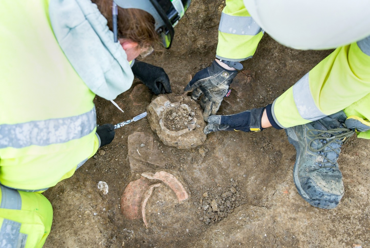
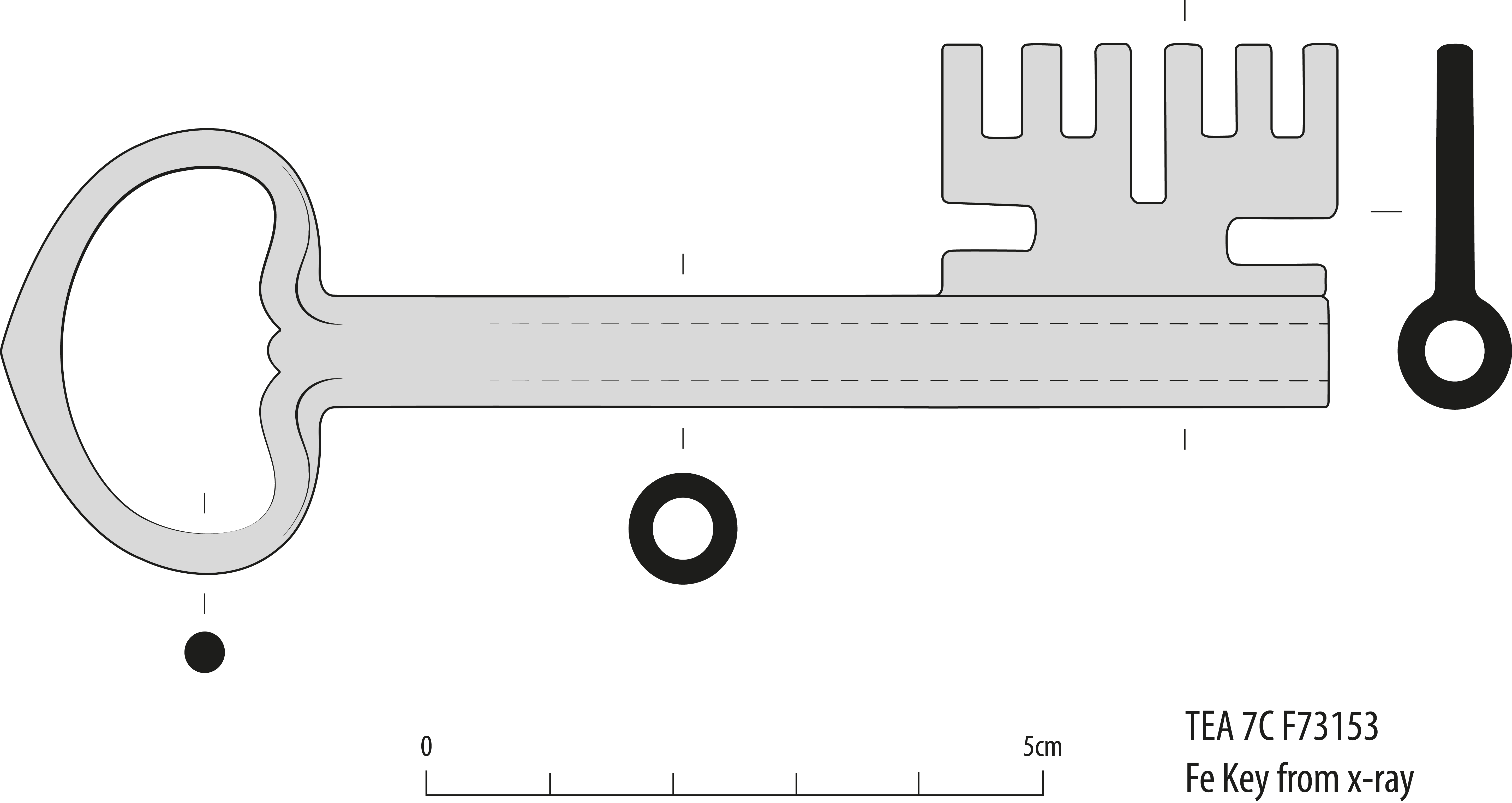
At Houghton, the ceramic building material was solely found in features in the southern part of the settlement. A cleft half oak pole with treenail holes was also recovered from the south street (Trackway 3), most likely a roof timber as the holes were at the right distance to fasten rafters to the main frame and there was evidence for soot staining. An iron rotary key and padlock (F73153 ; F76185) were also recovered from this settlement, showing that some of the occupants of Settlement 5 felt there was a need to protect their property (Figs 6.15 and 6.16).

Figure 6.15
Figure 6.15: Reconstruction drawing of iron rotary key (F 73153 )
Figure 6.16
Figure 6.16: Photo of iron barrel padlock (F 76185 )

Medieval Economy, Agriculture, Industry and Society

Agricultural and pastoral economy

The medieval economy of Houghton was very likely a dual economy characterised by small-scale arable and pastoral farming and small-scale industrial activities combined with a woodland economy and possibly trade from the Great North Road. Agricultural activities, including crop cultivation and animal husbandry, would, however, have served as the primary occupation for the majority of the population. The cultivation of staple crops such as wheat, barley, oats, peas, and beans, which were commonly grown in medieval England, also took place in Houghton.

The environmental evidence from the samples recovered from Houghton indicated intensification in agricultural practices during the medieval period, represented by a rich assemblage of cereal grains including free-threshing wheat and six-row hulled barley (González Carretero 2024). The environmental evidence also suggests well-maintained agricultural soils and a diverse assortment of wild seeds, indicating a flourishing agricultural environment encompassing woodland management practices.

Animal husbandry held significant importance in the rural economy of medieval England. Livestock farming, involving the rearing of cattle, sheep and pigs, played a vital role in meeting the subsistence and economic needs of the population (Faine 2024b). The faunal assemblage discovered in Houghton primarily consisted of cattle, followed by sheep or goats and three complete pig remains, along with remains of domestic fowl. Evidence of fishing was characterised by eel and salmon remains. Woodland access would have provided additional areas for animal grazing and foraging. The animals provided not only a source of food but also raw materials, such as wool and hides, which were utilised in the production of textiles and leather goods.

Hunting in medieval England was subject to strict regulations, with hunting rights typically restricted to the nobility. Forest laws governed hunting activities in royal and some non-royal forests and transgressions of these laws were severely penalised. However, evidence from Houghton's animal bone assemblage suggests that the villagers likely engaged in hunting within or near the local forest, as indicated by the remains of various wild game animals such as deer, rabbit, and hare. The presence of wild game animals in the faunal assemblage and the discovery of a metal arrowhead of a type used in hunting (F7039; Fig. 6.17), support this proposition.

Figure 6.17
Figure 6.17: Medieval iron arrow head (F 7039 )

Horse remains were limited in Houghton, likely serving as mounts and cart horses. Cattle were bred and utilised for on-site consumption as well as for export. The evidence suggests that cattle were processed and consumed within the settlement. Sheep, on the other hand, were primarily raised for wool production, as indicated by evidence of on-site breeding and the export of high-quality wool. Pigs were bred and slaughtered on-site, with evidence of butchery practices.

The concentration of animal bone in specific areas of the site, such as Linear Boundary 5 and the southern street (Trackway 3), suggests designated locations for the processing of animals. Structure 7BC.513 also stands out as a significant structure associated with animal processing, considering the substantial proportion of animal bone recovered from this specific area. The structure was interpreted as a possible butcher's shop (see Two special buidlings).

Woodland economy

Documentary sources (EYRE Rolls of Huntingdon in Turner 1901) provide a connection between the hamlet of Houghton and Brampton Wood (as well as Harthay Wood), stating that the wood was said (by local people giving evidence to Justices during Pleas of the Forest in 1255) to have been common up to 1154. The king, the bishop of Ely and Henry de Hastings all had some interest in the timber and wood in Brampton Wood, but tenants probably had some access to wood and pasture (Carpenter 2008).

The archaeological evidence for this association of the hamlet to the nearby woods is limited as the majority of woodland resources utilised are biodegradable and have not survived.

Nevertheless, the significance of woodlands in the medieval economy cannot be overlooked. Timber served as a crucial resource for construction, shipbuilding, and tool production, while firewood played a primary role in domestic heating and energy generation. The demand for wood extended beyond these conventional uses. Industries such as ironworking relied on charcoal, while tanning and glass production depended on bark. The woodland economy catalysed various economic activities, fostering trade and craftsmanship. Although these activities might not be readily apparent in the archaeological record, certain archaeological features identified at Houghton could be interpreted as integral components of the woodland economy. For instance, the streets at Houghton likely facilitated timber exports. The western street (Trackway 4) probably served as the primary connection between the wood and the hamlet, while the northern street (Trackway 2) may have been dedicated to domestic trade. The southern street (Trackway 3), situated along the southern edge of the hamlet, might have facilitated the transportation of timber and other woodland products to the Great North Road for trade in distant markets.

Woodlands and royal forests provided not only land for assarting (during disafforestation or with payment of fees) but also pasture for various types of livestock. The concentrated presence of animal bone remains in Linear Boundary 5 and the southern street (Trackway 3), closer to Brampton Wood access, could indicate that the processing of meat products was carried out nearer the area where the animals were killed, perhaps for easy access to trade beyond the local area along the southern street (Trackway 3) as well as domestic consumption.

Furthermore, the production of charcoal and other fuels within forests and woodlands would have served both domestic activities and exportation, supplying landlords, manors, the king, or the broader market. The primary market for fuel was likely associated with fuel-consuming industries, with iron production potentially being the most significant (Birrell 1980, 97). Archaeological evidence of this activity can perhaps be found in the 'burnt pits' identified across Houghton.

At Houghton, the produced fuel would have met the needs of the local smithy and possibly the local nearby industries such as the smelting furnaces and smithy at Godmanchester (Webster and Cherry 1975, 259-60), as well as for domestic cooking, including smoking fish, meat and cheese. Documentary evidence suggests that the forest and woodland economy were closely intertwined with the local peasantry, as many peasants living in or near forests were employed, at least part-time, in forest industries (Birrell 1980, 92). It is reasonable to assume that a similar dynamic existed at Houghton.

Industry

The remains of the smithy found at Houghton indicates the presence of a blacksmith, although no specific historical evidence regarding a resident blacksmith has been discovered. It is reasonable to assume that the blacksmith would have fulfilled the community's needs for tools, repairs, domestic items, and possibly served the demands of travellers along the Great North Road, a major route at the time.

The medieval blacksmith played a pivotal role in society, being central to the medieval economy. They were skilled artisans responsible for forging iron and creating a wide range of metal goods. Blacksmiths produced tools and weapons essential for agriculture and warfare, as well as crafting household items, decorative objects, and conducting repairs. Their craftsmanship was highly valued, and they held respected positions within their communities, passing down their skills through apprenticeships and participating in local events and ceremonies.

The medieval blacksmith's workshop was a bustling centre of activity, typically situated in the peripheral part of the village or town or along a road. It served as a focal point where locals would gather to observe the blacksmith's work and seek their services. In Houghton, the smithy likely catered to travellers along the Great North Road, with convenient access via the northern street (Trackway 2).

Other industrial activities are less clear and based on the assemblages of artefacts and archaeological evidence (Sillwood 2024c). The presence of specific artefacts, such as two stone spindle whorls (plus five from the subsoil) (F7171, F73278), an iron heckle tooth (F73022), and a pair of iron scissors (F73137; Fig. 6.18), supports the archaeological evidence of textile working. Additionally, the recovery of a lead weight (F72025 ) from the subsoil indicates some form of weighing and measuring, while the discovery of a punch and auger (F7160, F7358) implies woodworking activities. Documentary records suggest brewing was also an activity practised at Houghton, where in 1350 at least 18 brewers resided.

Figure 6.18
Figure 6.18: Medieval pair of scissors (F73137 )

Society

The absence of burials in these archaeological excavations hinders our understanding of the people who once inhabited the medieval settlements and villages. However, in the case of Houghton, both archaeological and documentary evidence offer valuable insights into the identity of its inhabitants.

According to the 1279 Hundred Rolls, Houghton was home to 34 individual tenants, with at least 20 of them occupying houses and associated buildings. These tenants owned lands totalling 240 acres of arable land and 37 acres of meadow. The exact details of pasture are not provided, as it would have involved shared grazing on commons, which couldn't be expressed in terms of acreage. It is worth noting that the villagers of Houghton had a uniform legal status as sokemen, meaning they paid cash rent, were not obliged to provide labour services, and fell under the jurisdiction of the lord of Brampton's court. The median rent they paid was 7d per acre per annum, which compares with an average of 3d per acre for free tenants in a sample of 60 Huntingdonshire villages, although the highest was recorded as 15d per acre (Kanzaka 2002, 611).

The status of the Houghton villagers as sokemen was uncommon, as many settlements in Huntingdonshire had a higher proportion of customary or servile tenants. Additionally, the Houghton tenants enjoyed the privilege of belonging to an 'ancient demesne' manor, which provided them with special legal procedures for land transfer. These tenants could seek protection from the king if their rents and services were increased, as seen in 1241-2 when they negotiated with the king for protection but were eventually forced by their lord to pay tallage. In response, they rebelled and reclaimed cattle seized by the authorities in 1242 and 1338. The Calendar of Patent Rolls from 1338-40 includes a list of individuals who participated in the 1338 tallage revolt. Among them, seven were residents of Houghton, including William Aley, who is mentioned in the 1350 Brampton court records as one of 18 brewers based in Houghton.

Another individual mentioned in the records is John Hicson, a young man who moved to Houghton from Ellington, less than 3km to the west, in 1447. This might be associated with Phase 4 of the archaeological evidence, which indicates limited new habitation on the site. The archaeological and artefactual evidence supports the notion that the inhabitants of Houghton were relatively poor and lacked significant social stratification. Most of the houses in the settlement were small, and the majority of landholdings were less than 8 acres. It is possible that this would not have been sufficient to support an average family although part-time participation in woodland activities might have offered further economic support.

The pottery assemblage from Houghton consisted mainly of unglazed St Neots and developed St Neots ware characterised by strictly utilitarian forms such as jars, bowls and jugs. Similarly, only a small number of artefacts associated with personal adornment were found, such as three copper-alloy buckles in stratified contexts, suggesting that luxury items were not commonly owned by the inhabitants owing to economic constraints. Though it may be that such items were efficiently recycled by the local smith.

The documentary evidence associated with royal and manor courts indicates that by the 13th century, surnames 'were fast replacing patronymics' (DeWindt 1980, 48) although they broadly still reflected some occupations. The name Webster, in association with Houghton, survives in the documentary records. This name, in fact, appears twice among the Houghton participants, in the 1338 rebellion.

The surname 'Webster' has its roots in England and originated during the Middle English period as an occupational surname for individuals involved in weaving although the name not only denotes the occupation of weaving but also reflects the social status and economic standing of those bearing the name. Weavers were esteemed members of their communities, playing a vital role in the medieval economy and often enjoying special privileges within guilds, which regulated the trade.

In 1350, a fulling mill was working at Brampton, finishing woollen cloth woven in the surrounding countryside (Hunts Archives Box 4/3A). Thus, in the case of Houghton, the historical documents, etymology of the name, and archaeological evidence align to suggest perhaps the presence of a Webster family engaged in textile production on-site.

The Hundred Rolls also list an individual named Woodward, living in Houghton in 1279 which could be an indication of an occupational name, suggesting in this case an association with the nearby woods.

Both the documentary and archaeological evidence suggest that the community at Houghton included farmers, herders, butchers, bakers, woodcutters (or other wood-associated craftsmanship) and individuals involved in food and drink preparation as well as textile production.

The Great North Road and Houghton

Houghton developed on the western edge of the territory of Brampton, c. 200m west of the Great North Road and this location must have played a role in its development. In medieval England, the road network played a crucial role in facilitating communication, trade, and transportation. These roads, commonly known as 'highways', formed the backbone of the medieval communication network, connecting various towns, villages, and cities across the country. Examining the development and significance of these medieval roads provides valuable insights into the socio-economic and political landscape of the era.

Medieval roads were primarily constructed to meet local transportation needs and were generally narrow and inadequately engineered by present-day standards (Hindle 2015, 45). Constructed using natural materials such as gravel, dirt, and clay, these roads lacked advanced engineering techniques. Consequently, they often exhibited uneven surfaces, were prone to erosion, and became muddy, making travel challenging and arduous. Nonetheless, despite their limitations, medieval roads played a pivotal role in connecting communities and facilitating trade and commerce.

Medieval roads supported economic activities, serving as major trade routes. They enabled the transportation of goods, including agricultural produce, manufactured goods, and other commodities, between towns and markets. An example of this at Houghton is the presence of pottery types from the St Neots and Huntingdon areas as well as Lyveden-Stanion pottery types from the west, suggesting trade movements north to south and east to west following the existing routeways. The accessibility of roads was crucial for the growth of local industries and markets, as it allowed merchants and traders to transport their goods to different regions. Moreover, roads served as vital links connecting towns and cities to ports, facilitating the movement of goods in and out of the country and promoting international trade. At Houghton, it would have favoured the trade in woodland goods such as timber.

Documentary evidence, such as the itineraries of Richard I, King John, Henry III, and Edward I, highlights the significant movement of people during this period. This included royal and military personnel as well as cattle drovers, particularly from the time of the Norman Conquest onwards (Stenton 1936, 4). An interesting example is the itinerary of William de Percehay, formerly the sheriff of York, who, in the summer of 1375, transported the ransom of David, the King of Scots, from York to London in six days (Stenton 1936, 17). William's convoy carried sacks of silver pennies and covered an average distance of 32 miles per day, totalling 192 miles. After safely delivering the cargo and spending a night in London, he returned to York in five days, travelling via Royston and Stamford along the Great North Road. This itinerary would have taken William in close proximity to Houghton, providing access to its amenities, including the local blacksmith, if needed.

Post-Medieval and Modern Archaeology of the A14

The agricultural-focused activity across the A14 archaeological mitigation carried on into the post-medieval and modern periods. The majority of this evidence was represented by ridge-and-furrow cultivation remains, boundary ditches, fence-lines and parish ditches visible on the 1888 OS map, such as for example, the parish boundary between Godmanchester and Offord Cluny identified at River Great Ouse Landscape Block (Atkins and Douthwaite 2024).

Occasional structures possibly associated with agricultural activities were identified across the scheme. At Alconbury, for example, a post-medieval structure comprising seven post-holes forming the south-west corner of a square or rectangular building was identified. It measured 6m east to west and 3m north to south and was likely a barn or outbuilding associated with the still existing farm to the north. At Bar Hill, mortared brick foundations of a building were identified in the north-western part of the site. It is very likely that the foundations, approximately 5.2m wide, belonged to the post-medieval farm labelled as 'Rhadegund Building' visible on the 1951 Ordnance Survey map. At Fenstanton Gravels, evidence of a 15th to 16th-century agricultural enclosure was also identified. Further evidence for other post-medieval activity includes a trackway (TEA 29), a well (TEA 26), and the foundations of 19th to 20th-century buildings (TEA 27), all in Fenstanton Gravels Landscape Block. At West of Ouse (TEA 16) a brick culvert was identified across the area.

Evidence for post-medieval industry was represented by gravel and clay quarrying identified at Brampton South, Conington, Fenstanton Gravels and Brampton West. Post-medieval brick production was also identified at Brampton West (discussed further below). The majority of the post-medieval and modern evidence was, however, identified at Brampton West with Settlement 6 identified as Grove Farm.

Post-medieval period at Brampton West (1500-1750)

During the post-medieval period, the Brampton West area was primarily used for agricultural activities. After the abandonment of Houghton in the 15th century, agricultural practices continued uninterrupted, with Field System 5 being the most significant set of remains. This system consisted of field boundaries dividing the area into small fields. Field System 5 maintained the same alignment as the late Saxon fields (Field System 2) and the medieval furrows (Field System 4), suggesting continuity in landscape division since at least the Saxon period. In the western part of TEA 7C, the 1772 Inclosure Map (Fig. 6.19) revealed the survival of Trackway 2, 'waste ground' adjacent to the trackway, and Linear Boundary 5. Additionally, two sheep burials (Pit Group 7BC.610) in the northern part of TEA 7BC were dated to the post-medieval period (cal AD 1520-1800), along with Linear Boundary 202 in TEA 12.

Figure 6.19
Figure 6.19: 1772 Inclosure Map overlain by Brampton West excavation outline

The Inclosure Map also reveals that several areas of the Brampton West Landscape Block were held in copyhold by Sir Robert Bernard: the land of the Saxon settlement BW3 was held as his 'tenth Allotment', the 'Old Inclosure' bounded by Trackway 3 and Linear Boundary 5 (Trackway 3 being the 'Eighth Allotment'). The small enclosures on the south side of Trackway 3, and the land west of Trackway 2 and to the west of Trackway 4 were his 'Seventh Allotment', Trackway 2 itself being his 'Ninth Allotment'. Sir Robert Bernard of Brampton Park, was the 5th and last Baronet of Brampton and an important Huntingdonshire figure. He was an MP for Westminster in this period. The area of the unexcavated part of Houghton Deserted Medieval Village (DMV) was held as Glebe Land by the Reverend Mr Taylor. That so much of this village land was held (at least in copyhold) by one owner, might signify the full abandonment of the village and the absorption of its lands into Brampton in the early years of Inclosure in the parish.

It is difficult to ascertain exactly who were the people farming these fields at this time or where they lived, although it is possible to assume that they might have been associated with neighbouring farms. There seems to have been three farmsteads in this corner of Brampton parish in the mid-19th century: High Harthay, Grove Farm and Rectory Farm, along with Lodge Farm to the south and perhaps the lands of the former Houghton Field, mentioned in the 16th century, were divided up among some or all of these farms at or even before Inclosure in the 1770s.

Modern period at Brampton West (1750-1950)

Most of the Brampton West Landscape Block was still under agricultural cultivation in the modern period, with the field systems generally arranged in a similar way from the early 19th century prior to the A14 construction works in the 21st century. These field systems would have formed the agricultural areas around two farms - Grove Farm in the northern part of the landscape block, and Brampton Lodge Farm at the junction of TEAs 10 and 11, although no remains of the latter were found. The remains of Grove Farm (BW6) were uncovered in the northern part of the landscape block, alongside the surrounding field system and two brick kilns. Elsewhere across the landscape block were the remains of modern agricultural activities and quarrying.

Grove Farm - Brampton West Settlement 6

Remains of the modern 'Grove Farm' (BW6) were identified in the northern part of the landscape block (Fig. 6.20). This comprised structural remains associated with the farm itself, two brick-lined wells, and boundaries surrounding the farmyard. Surrounding this was the modern field system shown on OS Maps (Field System 6), and two brick kilns. Pottery recovered from the farm was mainly refined earthenware, with some other 18th/19th century types such as Derbyshire stoneware. Most was recovered from Structure 7BC.339 and two pits (734755) and (764721).

Figure 6.20
Figure 6.20: Plan of Grove Farm (BW6) in Brampton West

Grove Farm was shown on historic maps from at least the 1888 First Edition OS Map (Fig. 6.21) until the 1966 OS Map. It is shown on a 1969 aerial photograph (HSL UK 69 876) but was destroyed before the 1970 OS Map. The central farm complex comprised a series of rectangular buildings surrounding a courtyard, with one further building to the south and two smaller enclosed areas (potentially yards) to the south and west. Few changes to the layout of this farm complex are shown on the historic OS maps, and no evidence for this was uncovered in the archaeological excavations. The archaeological remains of Grove Farm were represented by brick foundations of three buildings - Structures 7BC.339, 340 and 341 - all of which are shown on the 1888 First Edition OS Map.

Figure 6.21
Figure 6.21: Extract from the 1888 1:2,500 OS Map of Huntingdonshire, showing Grove Farm (Courtesy of Huntingdon Archives)

Census research showed that the farm appears to have been managed by James Gray and his family, who took occupancy somewhere between 1851 and 1861. According to baptism records, James Gray was born in Titchmarsh, Northamptonshire, on the 3rd of March 1818 and was baptised on the 21st of June 1818.

The 1851 census records his residency at Titchmarsh, Northamptonshire, along with his wife Susannah (33 years old), two sons (William 7 and Lewis 5 years of age), two daughters (Susannah 3 years old and Ann 7 months old) and two servants (Jeremiah Hawkins 17 years old and Mary Fox, 16 years old). His occupation is listed as a 'Farmer of 230 acres and employing 3 labourers'. The 1861 census records his residency as Grove Farm, Huntingdonshire, and his occupation as a 'Farmer of 476 acres, employing 2(?) men and 2 boys'. With him are listed his wife Sussey (Susannah 43 years old), three sons (William 17 years old, Lewis 15 years old and James 8 years old), four daughters (Susannah 12 years old, Ann 10 years old, Jane 8 and Mary 4 years old) and one servant (Catherine Bright 16 years old).

Although the 1871 census does not specify the residency, James Gray and his family remain in the same parish of Great Catworth, approximately 10km north-west of Grove Farm. As his occupation is listed as a 'Farmer of 470 acres and employing eleven men and two boys, it is safe to assume that his residence was still Grove Farm. His two elder daughters do not appear as part of his household anymore although Ann reappeared in the 1881 census. The 1871 census also lists two visitors - WF Gray Ibbs, 13, and Charles Ibbs, 10 - very likely relatives of the family. By 1881, although still resident at Grove Farm, Mister James Gray appeared to have sold some of his lands as the entry states that he was 'a farmer of 300 acres employing four men and two boys'. His wife, his two younger sons and the three younger daughters (including Ann now 29 years old) resided with him at Grove Farm. His eldest son was now married with four children and listed as a 'farm bailiff in Little Catworth'. James Gray died on the 16th of June 1890 at Catworth leaving a Personal Estate of £1,002 16s (which in today's money would be approximately £128,581.86).

Post-medieval Industry

Two 19th-century brick kilns were excavated within Field System 6. These were likely used for producing bricks for Grove Farm and other nearby agricultural buildings (Fig. 6.22). Both kilns were rectangular; however, Brick Kiln 7BC.136 was set on the ground and was open to the air, whereas Brick Kiln 7BC.344 was sunk into the ground with a superstructure over it. Both brick kilns dated to the 19th century - Brick Kiln 7BC.136 to the 1830s and Brick Kiln 7BC.344 to the 1880s (Figs 6.22-26).

Figure 6.22
Figure 6.22: Plan of Brick Kiln 7BC.136
Table 6.4. Brick Kilns
ContextDimensions
(L x W x D)
Material Shape Date
7BC.136 7.5m x 4m x 0.36m Red bricks not mortared rectangular 1830s
7BC.344 10.7m x 5.7m x 1.2m Concrete floor, red bricks not mortared (?)rectangular1880s

Brick Kiln 7BC.136 was producing bricks that measured 222-226mm by 98-108mm by 57-65mm (Betts 2024b). Some were grey where burnt (Figs 6.23-6.25). Occasionally straw marks were observed on the stretcher-faces, suggesting that the bricks were stacked vertically, with horizontal pressure marks where one brick had pressed into the brick below in an unfired stack. One thumb impression was noted, and one X-shaped mark, likely a batch mark. An unusual feature of the bricks is that their top surface appears to have been scrapped sideways, where they would normally have been scrapped lengthways.

Figure 6.23: Brick Kiln 7BC.136 under excavation
Figure 6.24: Brick Kiln 7BC.136 after excavation
Figure 6.25: Photogrammetry of Brick Kiln 7BC.136

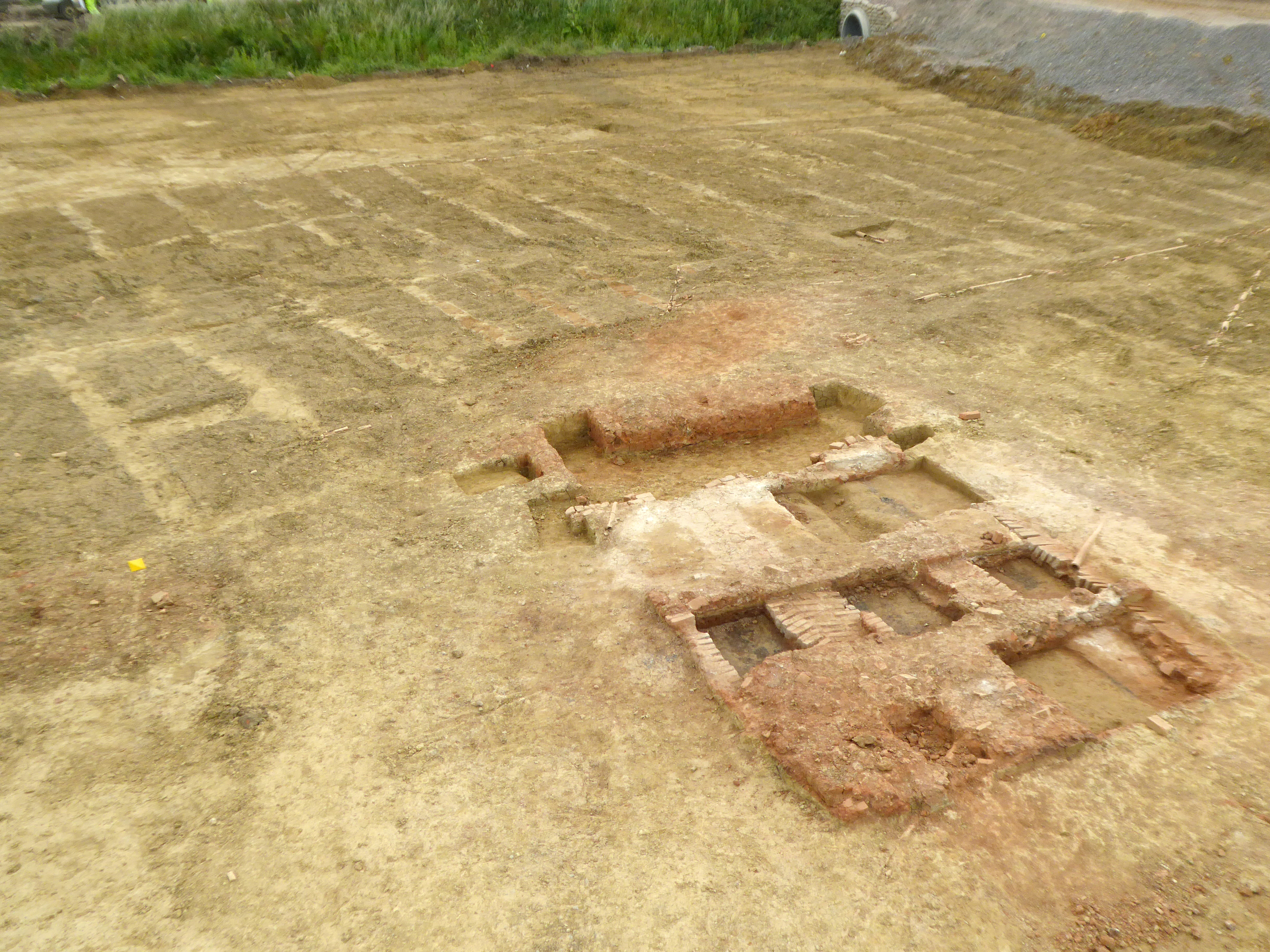
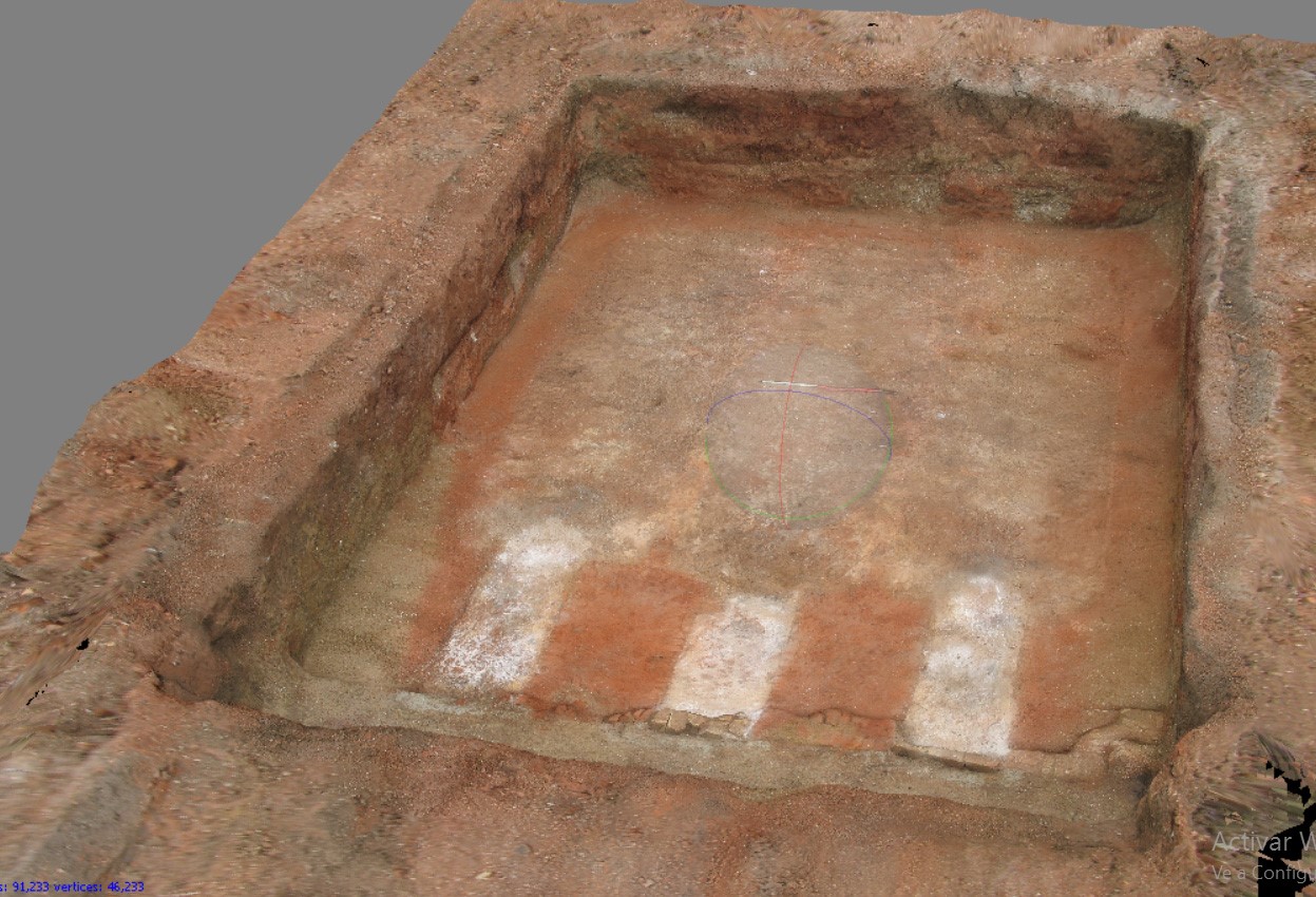
The bricks recovered from Kiln 7BC.344 varied in colour, measuring 222-230mm by 96-110mm by 63-69mm (Fig. 6.26). The kiln also appears to have been producing thinner ceramic items (possibly floor tiles) and drains. It is unclear whether the roof tiles recovered from the kiln were from the structure itself or the products of the kiln.

Figure 6.26
Figure 6.26: Photo of bricks fused together during firing from Kiln 7BC.344, context (070637)

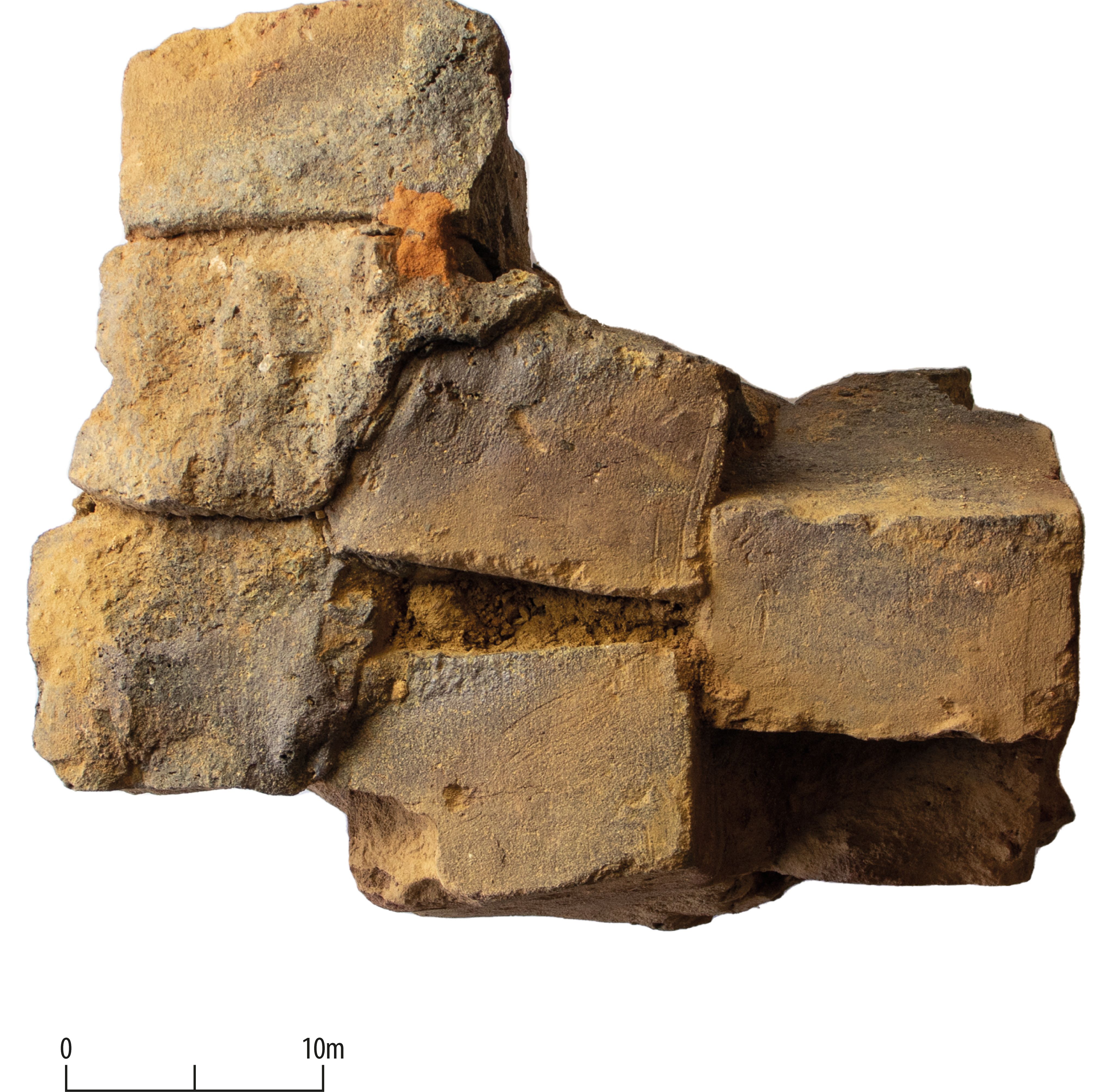
Quarries (for clay) were identified around both kilns, and there was evidence for 'stanks' (shallow rectangular pits for settling wet clay and removing impurities) around Brick Kiln 7BC.136. There was no obvious evidence for structures where other activities associated with brick production were based, such as mould-making, moulding or drying. These activities may have taken place in relatively short-lived structures difficult to identify in the archaeological record.

Conclusions

The archaeological investigations conducted as part of the A14 Improvement Scheme have provided valuable insights into the transition from the later Saxon to the medieval period as well as from the medieval to modern, highlighting the predominantly agricultural character of the area that was maintained throughout time. This investigation has also offered the rare opportunity to explore the archaeological remains of a medieval hamlet and the use of its surrounding landscape as well as the opportunity to compare the archaeological data with existing documentary evidence.

The development of Houghton and its territory appears to follow the development of the surrounding region which, after the Norman Conquest, was characterised by swathes of agricultural land with intermittent villages and farmsteads connected economically to Huntingdon and Cambridge that developed as vibrant centres of trade and industry. It is during this period that many villages in the region became nucleated and expanded. From the end of the 13th century and the beginning of the 14th century, a slow decline starts to appear in the region and many villages, such as Hamerton, Alconbury, Denton, Waresley as well as Houghton, present a gradual decline with final abandonment in the 15th and 16th centuries. Following this decline, the area of the A14 scheme appeared to maintain an agricultural character that has survived largely untouched until today.

← Previous chapter | Next chapter →

Primary Sources

Anglo-Saxon Chronicle, Translated and edited by Michael Swanton, London 1996
Appicus De Re Coquinaria
Columella De Rustica
Domesday Book, Penguin Books edition 1992
Henry of Huntingdon, Historia Anglorum, Edited by Thomas Arnold, London 1879
Pliny Natural History
Polybius Histories
Tacitus Agricola
Varro De Re Rustica

Secondary Sources

Note: References to other A14 outputs on the Archaeology Data Service (ADS) all have links to that resource. The references to the specialist reports from the different Landscape Block reports typically have associated letters after the date (e.g. Allison 2024a, Allison 2024d), which are fixed references to that particular report and may not run consecutively (a, b, c, etc.) in this bibliography.

A B C D E F G H I J K L M N O P Q R S T U V W X Y Z

A

Abrams, J. and Ingham, D. 2008 Farming on the Edge: Archaeological evidence from the clay uplands west of Cambridge, East Anglian Archaeology 123. https://eaareports.org.uk/publication/report123/

Aitken, E. and Wyles, S. 2024 'A14 Cambridge to Huntingdon, Cambridgeshire: Bar Hill plant remains'. https://doi.org/10.5284/1081250

Albarella, U. 2019 A Review of Animal Bone Evidence from Central England: Discovery, Innovation and Science in the Historic Environment, Research Report Series 61, Historic England.

Albion Archaeology 2022 'Land south of Cambridge Road and the former Dairy Crest site, Fenstanton, Cambridgeshire - Archaeological Mitigation Archive Report', Albion Archaeology [Unpublished Client Report].

Aldred, O. 2021 'Northstowe Phase 2a, Part 1 Cambridgeshire. An Archaeological Excavation Areas A1, AA2, AA3/4 and AA6', Cambridge Archaeological Unit [Unpublished client report].

Aldred, O. and Collins, M. forthcoming Of Other Spaces: Excavations across Longstanton and Oakington Northstowe Phases 1 and 2, CAU Landscape Archives: New archaeologies of the Cambridge region, Cambridge: McDonald Institute.

Alexander, M. and Pullinger, J. 2000 'Roman Cambridge. Excavations on Castle Hill 1956-1988', Proceedings of the Cambridge Antiquarian Society 88, 59-74.

Allen, M. 2014 'Chasing Sylvia's Stag: placing deer in the countryside of Roman Britain' in K. Baker, R. Carden and R. Madgwick (eds) Deer and People, Oxford: Windgather. 174-186. https://doi.org/10.2307/j.ctv13gvgms.18

Allen, M. 2017 'Pastoral farming' in M. Allen, L. Lodwick, T. Brindle, M. Fulford and A. Smith (eds) The Rural Economy of Roman Britain. New Visions of the Countryside of Roman Britain, Vol. 2, London: Britannia Monograph Series 30. 85-135.

Allen, M. and Smith, A. 2016 'Rural settlement in Roman Britain: morphological classification and overview' in A. Smith, M. Allen, T. Brindle and M. Fulford (eds) The Rural Settlement of Roman Britain. New Visions of the Countryside of Roman Britain, Vol. 1, London: Britannia Monograph Series 29. 17-43.

Allen, T. and Kamash, Z. 2008 Excavations at Spring Road Municipal Cemetery, Abingdon, Oxfordshire, 1990-2000 Volume 2, Oxford: Thames Valley Landscape monograph 28.

Allen, T., Miles, D. and Palmer, S. 1981 'Iron Age buildings in the Upper Thames region' in B. Cunliffe and D. Miles (eds) Aspects of the Iron Age in Central Southern Britain, Oxford: University of Oxford, Committee for Archaeology. 89-102.

Allison, E. 2024a 'A14 Cambridge to Huntingdon, Cambridgeshire: Alconbury Insect Remains'. https://doi.org/10.5284/1081249

Allison, E. 2024d 'A14 Cambridge to Huntingdon, Cambridgeshire: River Great Ouse Insect Remains'. https://doi.org/10.5284/1081255

Anderson, K. and Brudenell, M. 2010 'The pottery' in C. Evans and L. Ten Harkel (eds) 'Cambridge's early settlement and Via Devana: excavations at Castle Street', Proceedings of the Cambridge Antiquarian Society 99, 35-61.

Anderson, K., Hall, D. and Standring, R. 2009 'A Fieldwalking Survey of the Proposed A14 Route between Ellington and Girton', Cambridge Archaeological Unit [Unpublished client report]. https://doi.org/10.17863/CAM.100774

Armit, I. 2012 Headhunting and the Body in Iron Age Europe, Cambridge: Cambridge University Press. https://doi.org/10.1017/CBO9781139016971

Armour, N., Dodwell, N. and Timberlake, S. 2007 'The Roman Cemetery, The Babraham Institute, Cambridgeshire: An Archaeological Excavation', Cambridge Archaeological Unit [Unpublished client report 754].

Arnold, C. and Wardle, D. 1981 'Early medieval settlement patterns in England', Medieval Archaeology 25, 145-9.

Atkins CH2M 2016a 'A14 Cambridge to Huntingdon Improvement Scheme: Archaeological Mitigation Scheme; Archaeological Mitigation Specification: Section 1 Alconbury South', [Unpublished client report].

Atkins CH2M 2016b 'A14 Cambridge to Huntingdon Improvement Scheme: Archaeological Mitigation Scheme; Archaeological Mitigation Specification: Section 1 Ellington North', [Unpublished client report].

Atkins CH2M 2016c 'A14 Cambridge to Huntingdon Improvement Scheme: Archaeological Mitigation Scheme; Archaeological Mitigation Specification: Section 2 Brampton River Gravels', [Unpublished client report].

Atkins CH2M 2016d 'A14 Cambridge to Huntingdon Improvement Scheme: Archaeological Mitigation Scheme; Archaeological Mitigation Specification: Great Ouse Crossing', [Unpublished client report].

Atkins CH2M 2016e 'A14 Cambridge to Huntingdon Improvement Scheme: Archaeological Mitigation Scheme; Archaeological Mitigation Specification: Ermine Street West', [Unpublished client report].

Atkins CH2M 2016f 'A14 Cambridge to Huntingdon Improvement Scheme: Archaeological Mitigation Scheme; Archaeological Mitigation Specification: Ermine Street East' [Unpublished client report].

Atkins CH2M 2016g 'A14 Cambridge to Huntingdon Improvement Scheme: Archaeological Mitigation Scheme; Archaeological Mitigation Specification: Potton Road Gravels', [Unpublished client report].

Atkins CH2M 2016h 'A14 Cambridge to Huntingdon Improvement Scheme: Archaeological Mitigation Scheme; Archaeological Mitigation Specification: A14 Roman Road South', [Unpublished client report].

Atkins CH2M 2016i 'A14 Cambridge to Huntingdon Improvement Scheme: Archaeological Mitigation Scheme; Archaeological Mitigation Specification: Swavesey South' [Unpublished client report].

Atkins CH2M 2016j 'A14 Cambridge to Huntingdon Improvement Scheme: Archaeological Mitigation Scheme; Archaeological Mitigation Specification: Bar Hill North', [Unpublished client report].

Atkins CH2M 2016k 'A14 Cambridge to Huntingdon Improvement Scheme: Archaeological Mitigation Scheme; Archaeological Mitigation Specification: Bar Hill East', [Unpublished client report].

Atkins, R. 2024 'A14 Cambridge to Huntingdon, Cambridgeshire: Fenstanton Gravels Landscape Block Analysis Report'. https://doi.org/10.5284/1081254

Atkins, R. and Douthwaite, A. 2024 'A14 Cambridge to Huntingdon, Cambridgeshire: River Great Ouse Landscape Block Analysis Report'. https://doi.org/10.5284/1081255

Atkins, R. and Reid, A. 2022 'Early Anglo-Saxon settlement and a mid to late seventh-century cemetery on land west of Brampton', Proceedings of the Cambridge Antiquarian Society 61, 117-44.

Atkinson, R.J.C., Piggott, C.M. and Sandars, N.K. 1951 Excavations at Dorchester, Oxon. First Report, Oxford: Ashmolean Museum.

B

Bailey, L. 2024f 'A14 Cambridge to Huntingdon, Cambridgeshire: West of Ouse Charcoal'. https://doi.org/10.5284/1081256

Bailey, L. 2024i 'A14 Cambridge to Huntingdon, Cambridgeshire: Conington Charcoal. https://doi.org/10.5284/1081253

Balchin, N. and Filby, P. 2001 A Guide to the Industrial Archaeology of Cambridgeshire and Peterborough, Association for Industrial Archaeology.

Bamford, H.M. 1982 Beaker Domestic Sites in the Fen Edge and East Anglia, East Anglian Archaeology 16. https://eaareports.org.uk/publication/report16/

Bang, P.F. 2008 The Roman Bazaar: a comparative study of trade and markets in a tributary empire, Cambridge: Cambridge University Press.

Banks, P. and Perrin, R. 2024 'A14 Cambridge to Huntingdon, Cambridgeshire: Fenstanton Gravels Iron Age and Roman pottery'. https://doi.org/10.5284/1081254

Barrett, J. 1989 'Food, gender and metal: questions of social reproduction' in M.L.S. Sørensen and R. Thomas (eds) From Bronze to Iron: The Bronze Age-Iron Age transition in Europe, British Archaeological Reports (Int. Ser.) 483, Oxford: Archaeopress.

Barrett, J.C. 1990 'The monumentality of death: the character of Early Bronze Age mortuary mounds in southern Britain', World Archaeology 22(2), 179-189. https://doi.org/10.1080/00438243.1990.9980139

Barrett, J., Bradley, R.J. and Green, M.T. 1991 Landscape, Monuments and Society: the prehistory of Cranborne Chase, Cambridge University Press. https://doi.org/10.1017/CBO9780511735578

Bartlett, A.D.H. 2009 'A14 Improvement Ellington to Fen Ditton, Cambridgeshire. Report on Archaeogeophysical Surveys of Areas GP1 to GP7 (2008) and Proposed Reservoir Sites (2009)'.

Barton, R.N.E., Berridge, P.J., Walker, M.J. and Bevins, R.E. 1995 'Persistent places in the Mesolithic landscape: an example from the Black Mountain uplands of South Wales', Proceedings of the Prehistoric Society 61, 81-116. https://doi.org/10.1017/S0079497X00003042

Beresford, M.W. 1951 'The lost villages of Medieval England', The Geographical Journal 117(2), 129-147. https://doi.org/10.2307/1791650

Beresford, M. and Hurst, J. 1990 Wharram Percy Deserted Medieval Village, English Heritage.

Betts, I. 2024b 'A14 Cambridge to Huntingdon, Cambridgeshire: Brampton West Ceramic Building Material'. https://doi.org/10.5284/1081252

Biddulph, E. 2015 'Residual or Ritual? Pottery from the backfills of graves and other features in Roman cemeteries' in T. Brindle, M. Allen, E. Durham and A. Smith (eds) Proceedings of the Twenty-first Annual Theoretical Roman Archaeology Conference, Oxford: Oxbow Books. 41-53. https://doi.org/10.2307/j.ctvh1dw2c.7

Billington, L.P. 2016a Lithic Scatters and Landscape Occupation in the Late Upper Palaeolithic and Mesolithic: A Case Study from Eastern England, PhD thesis, University of Manchester. https://www.research.manchester.ac.uk/portal/files/54591471/FULLTEXT.PDF [Last accessed: 26 July 2021].

Billington, L.P. 2016b 'The Mesolithic' in C. Evans, J. Tabor and M. Vander Linden Twice-crossed River: Prehistoric and Palaeoenvironmental Investigations at Barleycroft Farm/Over, Cambridgeshire, The Archaeology of the Lower Ouse Valley 2, Cambridge: McDonald Institute Monograph. 128-35.

Billington, L.P. 2016c 'Worked flint' in C. Evans, J. Tabor and M. Vander Linden Twice-crossed River: Prehistoric and Palaeoenvironmental Investigations at Barleycroft Farm/Over, Cambridgeshire, The Archaeology of the Lower Ouse Valley 2, Cambridge: McDonald Institute Monograph. 153-59.

Billington, L.P. 2021a 'Palaeolithic to Mesolithic resource assessment', East of England Research Framework. https://researchframeworks.org/eoe/resource-assessments/palaeolithic-and-mesolithic/ [Last accessed: 6 December 2021].

Billington, L.P. 2021b 'Worked and unworked flint' in A. Haskins and P. Philips Mesolithic to Post-medieval Activity at Bartlow Road, Linton, Cambridgeshire, Client Report: Oxford Archaeology East.

Billington L.P. and Brudenell, M. forthcoming 'Ingress and Expansion: The development and dynamics of Iron Age settlement and land use along the A14 corridor' in West E. et al. (eds) Time Travellers' Tales: Essays from the A14 Cambridge to Huntington Archaeological Excavations, MHI Monograph.

Birrell, J.R. 1980 'Peasant craftsmen in the Medieval forest', The Agricultural History Review 17(2), 91-107.

Bishop, R.R. 2015 'Did Late Neolithic farming fail or flourish? A Scottish perspective on the evidence for Late Neolithic arable cultivation in the British Isles', World Archaeology 47(5), 834-855. https://doi.org/10.1080/00438243.2015.1072477

Black, E. 1994 'Villa-owners: Romano-British gentlemen and officers', Britannia 25, 99-110. https://doi.org/10.2307/526990

Blackbourn, K. 2017 Middle to Late Bronze Age funerary activity and Late Bronze Age occupation at Field End, Witchford [Unpublished client report]

Blackbourn, K. 2021 A Bronze Age Barrow with associated funerary evidence and a Roman trackway at Horseheath Road, Linton. Post-Excavation Assessment and Updated Project Design, Oxford Archaeology East.

Blackmore, L. 2024b 'A14 Cambridge to Huntingdon, Cambridgeshire: Brampton West Registered Finds: Anglo-Saxon'. https://doi.org/10.5284/1081252

Blackmore, L. 2024c 'A14 Cambridge to Huntingdon, Cambridgeshire: West of Ouse Registered Finds: Anglo-Saxon'. https://doi.org/10.5284/1081256

Blackmore, L. 2024d 'A14 Cambridge to Huntingdon, Cambridgeshire: Conington Registered Finds: Anglo-Saxon'. https://doi.org/10.5284/1081253

Blackmore, L. 2024e 'A14 Cambridge to Huntingdon Improvement Scheme Specialist Analysis Report: The Anglo-Saxon Registered Small Finds Overview'. https://doi.org/10.5284/1081262

Blackmore, L. and Blinkhorn, P. 2024 'A14 Cambridge to Huntingdon, Cambridgeshire: Brampton West Post-Roman pottery'. https://doi.org/10.5284/1081252

Blair, J. 2018 Building Anglo-Saxon England, Princeton: Princeton University Press. https://doi.org/10.1515/9781400889907

Blair, J. and Cole, A. in prep Functional Place-Names in the Anglo-Saxon Landscape

Blair, J., Rippon, S. and Smart, C. 2020 Planning in the Early Medieval Landscape, Liverpool University Press.

Blinkhorn, P. 2012 The Ipswich Ware Project: Ceramics, trade, and society in Middle Saxon England, Medieval Pottery Research Group Occasional Paper 7.

Blinkhorn, P. 2024f 'A14 Cambridge to Huntingdon, Cambridgeshire: Conington Post-Roman Pottery'. https://doi.org/10.5284/1081253

Boismier, W.A. 2021 'Lithic assemblage assessment' in W.A. Boismier, D.S. Young, R. Banerjea, C.R. Batchelor, T. Hill, J-L. Schwenninger, J. Weinstock and L. Goodman TEA28 BP3 Palaeolithic Watching Brief. Assessment Report and Updated Project Design. Volume 2: Technical Reports, 69-70.

Boismier, W.A., Allison, E., Ardis, C., Banerjea, R., Batchelor, C.R., Dark, P., Dudgeon, K., Green, C.P., Henderson, E., Ladocha, J., Weinstock, J., Young, D.S. and Schwenninger, J.-L. 2024 Investigation of Borrow Pit TEA28 BP3, Fenstanton, Cambridgeshire, UK, Internet Archaeology 67. https://doi.org/10.11141/ia.67.23

Boismier, W.A., Young, D.S., Banerjea, R., Batchelor, C.R., Hill, T., Schwenninger, J-L., Weinstock, J. and Goodman, L. 2021 TEA28 BP3 Palaeolithic Watching Brief. Assessment Report and Updated Project Design.

Booth, T.J., Brück, J., Brace, S. and Barnes, I. 2020 'Tales from the supplementary information: ancestry change in Chalcolithic-Early Bronze Age Britain was gradual with varied kinship organization', Cambridge Archaeological Journal 31(3), 379-400. https://doi.org/10.1017/S0959774321000019

Boulter, S. and Walton Rogers, P. 2012 Circles and Cemeteries: Excavations at Flixton Volume I, East Anglian Archaeology 147. https://eaareports.org.uk/publication/report147/

Bourne, J. 2017 The Place-Name Kingston and Royal Power in Middle Anglo-Saxon England, British Archaeological Reports B630, Oxford: Archaeopress. https://doi.org/10.30861/9781407315683

Bowsher, J. and Humphreys, O. 2024d 'A14 Cambridge to Huntingdon, Cambridgeshire: Fenstanton Gravels coins'. https://doi.org/10.5284/1081254

Bowsher, J. 2024f 'A14 Cambridge to Huntingdon, Cambridgeshire: Bar Hill Coins and Tokens'. https://doi.org/10.5284/1081250

Bradley, R. 1998 The Significance of Monuments. On the shaping of human experience in Neolithic and Bronze Age Europe, London: Routledge.

Bradley, R. 2003 'Neolithic expectations' in I. Armit, E. Murphy, E. Nelis and E. Simpson (eds) Neolithic Settlement in Ireland and Western Britain, Oxford: Oxbow Books. 218-22.

Bradley, R. 2007 The Prehistory of Britain and Ireland, Cambridge: Cambridge University Press. https://doi.org/10.1017/CBO9780511618574

Brindle, T. 2017 'Coins and markets in the countryside' in M. Allen, L. Lodwick, T. Brindle, M. Fulford and A. Smith (eds) The Rural Economy of Roman Britain. New Visions of the Countryside of Roman Britain, Vol 2, London: Britannia Monograph Series 30. 237-77.

Brittain, M. and Evans, C. 2019 The War Field Villa (Site VII) and other Phase 2 investigations (Sites I, VI and X), Cambridge Archaeological Unit [Unpublished client report 1435].

Brogan, S.N.B. 2022 These little piggies: Can geometric morphometrics provide insight into the exploitation strategies and diversity of suids from south-east England?, MA dissertation, University of Reading.

Brown, A.G., Meadows, I., Turner, S.D. and Mattingly, D.J. 2001 'Roman vineyards in Britain: stratigraphic and palynological data from Wollaston in the Nene Valley, England', Antiquity 75(290), 745-757. https://doi.org/10.1017/S0003598X00089250

Brown, L. 2008 'Charon's Obols? A case study in the role of coins in Roman burial ritual space' in C. Fenwick, M. Wiggins and D. Wythe (eds) TRAC 2007: Proceedings of the Seventeenth Annual Theoretical Roman Archaeology Conference, London 2007, Oxford: Oxbow Books. 121-130. https://doi.org/10.16995/TRAC2007_121_130

Brück, J. 1999 'Houses, lifecycles and deposition on Middle Bronze Age settlements in southern England', Proceedings of the Prehistoric Society 65, 145-166. https://doi.org/10.1017/S0079497X00001973

Brück, J. 2000 'Settlement, landscape and social identity: the Early-Middle Bronze Age transition in Wessex, Sussex and the Thames Valley', Oxford Journal of Archaeology 19(3), 273-300. https://doi.org/10.1111/1468-0092.00110

Brück, J. 2007 'The character of Late Bronze Age settlement in southern Britain' in C. Haselgrove and R. Pope (eds) The Earlier Iron Age in Britain and the near Continent, Oxford: Oxbow Books. 24-38. https://doi.org/10.2307/j.ctvh1dwqj.4

Brück, J. 2014 'Cremation, gender, and concepts of the self in the British Early Bronze Age' in C.P. Quinn, G. Cooney and I. Kuijt (eds) Transformation by Fire: The archaeology of cremation in cultural context, Arizona: University of Arizona Press. 119-39.

Brück, J. 2019 Personifying Prehistory: relational ontologies in Bronze Age Britain and Ireland, Oxford: Oxford University Press. https://doi.org/10.1093/oso/9780198768012.001.0001

Brück, J. and Booth, T.J. 2022 'The Power of Relics: the curation of human bone in British Bronze Age burials', European Journal of Archaeology 25(4), 440-462. https://doi.org/10.1017/eaa.2022.18

Brudenell, M.J. 2012 Pots, practice and society: an investigation of pattern and variability in the post-Deverel Rimbury ceramic tradition of East Anglia, PhD Thesis, University of York. https://etheses.whiterose.ac.uk/14230/1/629465.pdf

Brudenell, M. 2021 'Late Bronze Age to middle Iron Age Resource Assessment', East Anglian Regional Research Framework. https://researchframeworks.org/eoe/resource-assessments/late-bronze-age-to-middle-iron-age/

Brudenell, M., Barker, C., Tabor, J. and Wakefield, C. 2023 'Prehistoric continuity in the Cambridgeshire landscape: exploring recent excavations at Needingworth Quarry', Current Archaeology, July 29 2023. https://the-past.com/news/prehistoric-continuity-in-the-cambridgeshire-landscape-exploring-recent-excavations-at-needingworth-quarry/# [Last accessed December 2024]

Brughmans, T. and Pecci, A. 2020 'An inconvenient truth: evaluating the impact of amphora reuse through computational simulation modelling' in C.E. Duckworth and A. Wilson (eds) Recycling and Reuse in the Roman Economy, Oxford: Oxford University Press. 191-234. https://doi.org/10.1093/oso/9780198860846.003.0006

Buckland, P.C. 1978 'Cereal production, storage and population a caveat' in S. Limbrey and J.G. Evans (eds) The Effect of Man on the Landscape: the Lowland Zone, London: Council for British Archaeology Research Report 21. 43-5.

Bunn, D. (PCA) 2008 'Gradiometer Survey: A14 Ellington to Fen Ditton Improvements'.

Burrow, A. and Foard-Colby, A. 2006 Archaeological Evaluation at Brampton Road, Buckden Road, Buckden, Cambridgeshire, Northamptonshire Archaeology, Report no. 06/146 [Unpublished client report].

Butler, C. 2005 Prehistoric Flintwork, Stroud: The History Press.

C

Campbell, G. 2000 'Plant utilization: the evidence from charred plant remains' in B. Cunliffe The Danebury Environs Programme. The Prehistory of a Wessex Landscape, Oxford: Institute of Archaeology. 45-59.

Campbell, G. and Robinson, M. 2010 'The environmental evidence in Raunds Area Project (England)' in A. Chapman (ed) West Cotton, Raunds: a study of medieval settlement dynamics, AD 450-1450: excavation of a deserted medieval hamlet in Northamptonshire, 1985-89, Oxford: Oxbow Books. 427-515. https://doi.org/10.2307/j.ctv2p7j610.25

Campbell, K.G. 1997 'Spelt: agronomy, genetics, and breeding', Plant Breeding Reviews 15, Oxford: John Wiley and Sons. 187-213. https://doi.org/10.1002/9780470650097.ch6

Carlyle, S. and Chapman, A. 2002 Neolithic and Beaker Pits and a late Bronze Age/early Iron Age Droveway and Enclosure at Fenstanton, Cambridgeshire. Northamptonshire Archaeology Report.

Carpenter, D. 2008 'The Greater Part of the Vill was there': the struggle of the men of Brampton against their lord', Fine of the Month (December 2008; March 2009). https://frh3.org.uk/content/month/fm-12-2008.html and https://frh3.org.uk/content/month/fm-03-2009.html [Last accessed: 12 June 2021].

Caswell, E. and Roberts, B.W. 2018 'Reassessing community cemeteries: cremation burials in Britain during the Middle Bronze Age (c. 1600-1150 cal BC)', Proceedings of the Prehistoric Society 84, 329-357. https://doi.org/10.1017/ppr.2018.9

Chadwick, A.M. 2010 Fields for discourse. Landscape and materialities of being in South and West Yorkshire and Nottinghamshire during the Iron Age and Romano-British periods. A study of people and place, PhD thesis, University of Wales Newport. https://doi.org/10.5284/1000124

Chapman, A. 2010 West Cotton, Raunds: a study of medieval settlement dynamics, AD 450-1450: excavation of a deserted medieval hamlet in Northamptonshire, 1985-89, Oxford: Oxbow Books. https://doi.org/10.2307/j.ctv2p7j610

Chapman, A., Carlyle, S. and Leigh, D. 2005 'Neolithic and Beaker pits and a Bronze Age landscape at Fenstanton, Cambridgeshire', Proceedings of the Cambridge Antiquarian Society 94, 5-20.

Cherry, J. 1991 'Leather' in J. Blair and N. Ramsay (eds) English Medieval Industries, London: A&C Black. 295-319.

Christiansen, S. 1978 'Infield-outfield systems - characteristics and developments in different climatic environments', Geografisk Tidsskrift-Danish Journal of Geography 77(1), 1-5. https://doi.org/10.1080/00167223.1978.10649086

Christie, C. 2024 'A14 Cambridge to Huntingdon, Cambridgeshire: West of Ouse Landscape Block Analysis Report'. https://doi.org/10.5284/1081256

Christie, C. forthcoming 'Conspicuous by its absence: Bronze Age settlement on the A14' in E. West, C. Christie, O. Scholma-Mason, L. Billington, M. Brudenell, D. Moretti and A. Smith (eds) Time Travellers' Tales: Essays from the A14 Cambridge to Huntington Archaeological Excavations, MHI Monograph.

Clarke, G. et al. 2016 'A14 Cambridge to Huntingdon Improvement Scheme: Early Works Programme Archaeological Evaluation Report'. https://eprints.oxfordarchaeology.com/4878/

Clarke, R. 2006 Prehistoric activity, medieval occupation and post-medieval industry to the rear of Walden House, Huntingdon, Cambridgeshire: Post-excavation assessment and updated project design Report No. 858, Cambridge Archaeology [Unpublished client report].

Clarke, G. 2024 'A Middle Bronze Age Cremation Cemetery and an Anglo-Saxon Estate Centre at Stirtloe Lane and Lucks Lane, Buckden, Cambridgeshire Volume 1: Archaeological Excavation Report', internal report, Oxford Archaeology.

Clay, P. 2002 The Prehistory of the East Midlands Claylands. Aspects of settlement and land-use from the Mesolithic to the Iron Age in central England, Leicester Archaeology Monograph 9, Leicester: School of Archaeology and Ancient History, Leicester University. https://hdl.handle.net/2381/9428

Cleal, R. 1999 'The what, where, when and why of Grooved Ware' in R. Cleal and A. MacSween (eds) Grooved Ware in Britain and Ireland, Neolithic Studies Group Seminar Papers 3, Oxford: Oxbow Books. 1-8.

Collins, M. 2016 Northstowe, Phase 1 Cambridgeshire. Archaeological Post Excavation Assessment (Vol. 2). Areas F1, F2 and K, Unpublished Cambridge Archaeological Unit Report 1348.

Condron, F. 1997 'Iron production in Leicestershire, Rutland and Northamptonshire in Antiquity', Transactions of the Leicestershire Archaeology and History Society 71, 1-20.

Cool, H.E.M. 1983 A study of the Roman personal ornaments made of metal, excluding brooches, from southern Britain, PhD Thesis, University of Cardiff.

Cool, H.E.M. 2006 Eating and Drinking in Roman Britain, Cambridge: Cambridge University Press. https://doi.org/10.1017/CBO9780511489570

Cool, H.E.M. 2011 'Funerary contexts' in L. Allason-Jones (ed) Artefacts in Roman Britain. Their purpose and use, Cambridge: Cambridge University Press. 293-314.

Cool, H.E.M. 2020 'Vessel glass' in D.W. Fell (ed) A1 Leeming to Barton. Contact, concord and conquest. Britons and Romans at Scotch Corner, Northern Archaeological Associates Monograph Series 5.

Cool, H.E.M. and Baxter, M.J. 2016 'Brooches and Britannia', Britannia 47, 71-98. https://doi.org/10.1017/S0068113X16000039

Cooper, A. 2016 ''Held in place': Round barrows in the later Bronze Age of lowland Britain?', Proceedings of the Prehistoric Society 82, 291-322. http://dx.doi.org/10.1017/ppr.2016.9

Cooper, A., Garrow, D. and Gibson, C. 2020 'Spectrums of depositional practice in later prehistoric Britain and beyond. Grave goods, hoards and deposits "in between"', Archaeological Dialogues 27(2), 135-157. https://doi.org/10.1017/S1380203820000197

Cooper, A., Garrow, D., Gibson, C., Giles, M., and Wilkin, N. 2022 Grave Goods: objects and death in later prehistoric Britain, Oxford: Oxbow Books. https://doi.org/10.2307/j.ctv2npq9hx

Cox, C. 2014 'A14 Cambridge to Huntington Improvement Scheme, Cambridgeshire: Brampton TL 195 720 to Fen Drayton TL340 370; Assessment of Aerial Photographs for Archaeology', Air Photo Services Ltd [Unpublished client report].

Creighton, J. 2006 Britannia, the Creation of a Province, London: Routledge. https://doi.org/10.4324/9780203412749

Creighton, O.H. and Wright, D.W. 2016 The Anarchy: War and Status in 12th-Century Landscapes of Conflict, Liverpool: Liverpool University Press.

Crerar, B. 2016 'Deviancy in late Romano-British burial' in M. Millett, L. Revell and A. Moore (eds) The Oxford Handbook of Roman Britain, Oxford: Oxford University Press. 381-405. https://doi.org/10.1093/oxfordhb/9780199697731.013.023

Crewe, V. 2011 Barrows and buildings, ditches and dwellings: the appropriation of prehistoric monuments in early to middle Anglo-Saxon settlements, PhD thesis, University of Sheffield. https://etheses.whiterose.ac.uk/10375/

Croom, A.T. 2007 Roman Furniture, Stroud: The History Press.

Crummy, N. 2005 'From bracelets to battle-honours: military armillae from the Roman conquest of Britain' in N. Crummy (ed) Image, Craft and the Classical World: essays in honour of Donald Bailey and Catherine Johns, Monographies Instrumentum 29, Montagnac. 93-105.

Cummings, L.B. 2019 Rethinking the henge monuments of the British Isles, PhD thesis, Newcastle University. http://theses.ncl.ac.uk/jspui/handle/10443/4713

Cunliffe, B. 2005 Iron Age Communities in Britain, 4th edn, London: Routledge. https://doi.org/10.4324/9780203326053

Cupcea, G. 2016 'On police and administrative duties of the Roman military: regionarii', Acta Musei Napocensis 53(1), 151-77.

Cussans, J. 2024 'A14 Cambridge to Huntingdon, Cambridgeshire: Alconbury Animal Bone'. https://doi.org/10.5284/1081249

D

Dannell, G. and Wild, J.P. 1987 Longthorpe II The Military Works-depot: An episode in landscape history, London: Britannia Monograph Series 8.

Davies, P., Robb, J.G. and Ladbrook, D. 2005 'Woodland clearance in the Mesolithic: the social aspects', Antiquity 79(304), 280-288. https://doi.org/10.1017/S0003598X00114085

Davis, R. (Stratascan) 2016 'A14 Cambridge to Huntingdon Geophysical Survey Report'. https://doi.org/10.5284/1049554

Dawson, M. (ed) 2000 Prehistoric, Roman, and Post-Roman Landscapes of the Great Ouse Valley, York: Council for British Archaeology Research Report 119.

Dawson, M. 2000a 'The Ouse valley in the Iron Age and Roman periods: a landscape in transition' in M. Dawson (ed) Prehistoric, Roman and post-Roman Landscapes of the Great Ouse Valley, York: Council for British Archaeology Research Report 119. 107-30.

de Grossi Mazzorin, J., Riedel, A. and Tagliacozzo, A. 1998 'Horse remains in Italy from the Eneolithic to the Roman period', Proceedings of the 13th Congress of International Union of Prehistoric and Protohistoric Sciences 6(1), 87-92.

de Ligt, L. 1993 Fairs and Markets in the Roman Empire, Amsterdam: J.C. Gieben. https://doi.org/10.1163/9789004525573

Devaney, R. 2024a 'A14 Cambridge to Huntingdon, Cambridgeshire: Alconbury Flint'. https://doi.org/10.5284/1081249

Devaney, R. 2024b 'A14 Cambridge to Huntingdon, Cambridgeshire: Brampton South Flint'. https://doi.org/10.5284/1081251

Devaney, R. 2024c 'A14 Cambridge to Huntingdon, Cambridgeshire: Brampton West Flint'. https://doi.org/10.5284/1081252

Devaney, R. 2024d 'A14 Cambridge to Huntingdon, Cambridgeshire: West of Ouse Flint'. https://doi.org/10.5284/1081256

Devaney, R. 2024e 'A14 Cambridge to Huntingdon, Cambridgeshire: River Great Ouse Worked Flint'. https://doi.org/10.5284/1081255

Devaney, R. 2024f 'A14 Cambridge to Huntingdon, Cambridgeshire: Fenstanton Gravels Flint'. https://doi.org/10.5284/1081254

Devaney, R. 2024g 'A14 Cambridge to Huntingdon, Cambridgeshire: Conington Flint'. https://doi.org/10.5284/1081253

Devaney, R. 2024h 'A14 Cambridge to Huntingdon, Cambridgeshire: Bar Hill Flint'. https://doi.org/10.5284/1081250

Devaney, R. 2024i 'A14 Cambridge to Huntingdon Improvement Scheme Specialist Analysis Report: The Flint Overview'. https://doi.org/10.5284/1081262

DeWindt, A. 1980 'Peasants in the English Royal Courts: The Huntingdonshire Eyre of 1286, the Ramsey Abbey Banlieu Court of 1287, and the Huntingdonshire Assizes of 1287-88', Medieval Prosopography 1(2), 45-57.

Dickson, C.A. 1990 'Experimental processing and cooking of Emmer and Spelt Wheats and the Roman army diet' in D.E. Robinson (ed) Experimentation and Reconstruction in Environmental Archaeology 5, 9th Symposia of the Association of Environmental Archaeology, Roskilde, Denmark. Oxford: Oxbow Books. 33-40. https://doi.org/10.2307/j.ctvh1dp6m.8

Dietler, M. and Hayden, B. 2001 Feasts Archaeological and Ethnographic Perspectives on Food, Politics and Power, Tuscaloosa: The University of Alabama Press.

Dobney, K. 2001 'A place at the table: the role of vertebrate zooarchaeology within a Roman research agenda' in S. James and M. Millett (eds) Britons and Romans: advancing an archaeological agenda, York: Council for British Archaeology Research Report 125. 36-46.

Donaldson, P., Kinnes, I.A. and Wells, C. 1977 'The excavation of a multiple round barrow at Barnack, Cambridgeshire 1974-1976', The Antiquaries Journal 57(2), 197-231. https://doi.org/10.1017/S0003581500031164

Douthwaite, A. and Atkins, R. 2022 'A14 Cambridge to Huntingdon, Cambridgeshire, River Great Ouse Landscape Block Analysis Report, Headland Archaeology [Unpublished client report].

Duckham, A.N. 1963 Agricultural Synthesis: The farming year, London: Chatto and Windus.

Dungworth, D. 2015 Archaeometallurgy - Guidelines for Best Practice, Historic England. https://historicengland.org.uk/images-books/publications/archaeometallurgy-guidelines-best-practice/heag003-archaeometallurgy-guidelines/

Dungworth, D. and Cubitt, R. 2024i 'A14 Cambridge to Huntingdon Improvement Scheme Specialist Analysis Report: The Industrial Waste Overview'. https://doi.org/10.5284/1081262

Dungworth, D. and Cubitt, R. 2024c 'A14 Cambridge to Huntingdon, Cambridgeshire: Brampton West Industrial Waste'. https://doi.org/10.5284/1081252

Dungworth, D. and Cubitt, R. 2024e 'A14 Cambridge to Huntingdon, Cambridgeshire: River Great Ouse industrial waste'. https://doi.org/10.5284/1081255

Dyer, C. 1994 'The English Medieval village community and its decline', Journal of British Studies 33(4), 407-429. https://doi.org/10.1086/386063

Dyer, C. 2002 Making a Living in the Middle Ages: The People of Britain 850-1520, Yale University Press.

Dyer, C. 2010 'The crisis of the early fourteenth century. Some material evidence from Britain' in D. Boisseuil, P. Chastang, L. Feller and J. Morsel (eds) Écriture de l'Espace Social. Mélange d'Histoire Médiévale Offerts à Monique Bourin, 491-506. https://doi.org/10.4000/books.psorbonne.11237

E

Eckardt, H. (ed) 2010 Roman Diasporas. Archaeological approaches to mobility and diversity in the Roman Empire, The Journal of Roman Archaeology Supplementary Series 78.

Eckardt, H. and Müldner, G. 2016 'Mobility, migration, and diasporas' in M. Millett, L. Revell and A. Moore (eds) The Oxford Handbook of Roman Britain, Oxford: Oxford University Press. 203-223. https://doi.org/10.1093/oxfordhb/9780199697731.013.012

Ellis, C. 2004 A Prehistoric Ritual Complex at Eynesbury, Cambridgeshire, East Anglian Archaeology Occasional Papers 17.

Ellison, A. 1980 'Deverel-Rimbury urn cemeteries: The evidence for social organisation' in J. Barrett and R. Bradley (eds) Settlement and Society in the British Later Bronze Age, British Archaeological Reports 83, Oxford: Archaeopress. 115-26.

Elsdon, S.M. 1992 'East Midlands scored ware', Transactions of the Leicestershire Archaeological and Historical Society 66, 83-91.

Esmonde Cleary, S. 2000 'Putting the dead in their place: burial location in Roman Britain' in J. Pearce, M. Millett and M. Struck (eds) Burial, Society and Context in the Roman World, Oxford: Oxbow Books. 127-42.

Evans, C. 2013 Process and History. Romano-British Communities at Colne Fen, Earith: An Inland Port and Supply Farm, Cambridge Archaeological Unit Landscape Archive Series: The Archaeology of the Lower Ouse Valley 2, Cambridge.

Evans, C. 2021 Late Iron Age and Roman Resource Assessment, East of England Regional Research Framework for the Historic Environment. https://researchframeworks.org/eoe/

Evans, C. 2022 Modelling, Mimicking and Fighting Waters: Lower River Great Ouse and Ouse Washlands investigations, McDonald Institute for Archaeological Research.

Evans, C. and Cessford, C. 2015 'North West Cambridge: archaeology, art and mud', British Archaeology 37, York.

Evans, C. and Dickens, A. 2002 'Longstanton New Settlement, Archaeological Desktop Assessment', Cambridge: Cambridge Archaeological Unit.

Evans, C. and Hodder, I. 2006 A Woodland Archaeology. Neolithic sites at Haddenham, The Haddenham Project Volume 1, Cambridge: McDonald Institute Monograph.

Evans, C. and Knight, M. 1998 'The Butcher's Rise ring-ditches: Excavations at Barleycroft Farm, Cambridgeshire', Cambridge Archaeological Unit [Unpublished Client Report 283].

Evans, C. and Lucas, G. 2020 Hinterlands and Inlands, the Archaeology of West Cambridge and Roman Cambridge Revisited, CAU Landscape Archives: New Archaeologies of the Cambridge Region 3, Oxford: McDonald Institute Monographs.

Evans, C. and Mackay, D. 2004 'Longstanton, Cambridgeshire. A Village Hinterland. Cambridge Archaeological Unit', [Unpublished Client Report].

Evans, C. and Newman, R. 2010 'North-west Cambridge, University of Cambridge, Archaeological Evaluation Field Evaluation', Cambridge Archaeological Unit [Unpublished client report 921].

Evans, C. and Ten Harkel, L. 2010 'Cambridge's early settlement and Via Devana: excavations at Castle Street', Proceedings of the Cambridge Antiquarian Society 99, 35-60.

Evans, C. and Vander Linden, M. 2008 'The Godwin Ridge, Over, Cambridgeshire. A (wet-)landscape corridor', Notae Praehistoricae 28, 47-54.

Evans, C., Appleby, G.A., Mackay, D.A. and Amour, N. 2005 'Longstanton Cambridgeshire, A village Hinterland (II)', Cambridge Archaeological Unit [Unpublished client report].

Evans, C., Mackay, D. and Webley, L. 2008 'The Hutchinson Site, Addenbrooke's' in C. Evans (ed) Borderlands: The Archaeology of Addenbrooke's Environs, South Cambridge, CAU Landscape Archives: New Archaeologies of the Cambridge Region 1, Oxford: McDonald Institute Monographs. 23-133.

Evans, C., Mackay, D. and Webley, L. 2008 Borderlands: The Archaeology of the Addenbrooke's Environs, South Cambridge, CAU Landscape Archives: New Archaeologies of the Cambridge Region 1, Oxford: McDonald Institute Monographs.

Evans, C., Patten, R., Brudenell, M., and Taylor, M. 2011 'An inland Bronze Age: excavations at Striplands Farm, West Longstanton', Proceedings of the Cambridge Antiquarian Society 100, 7-45.

Evans, C., Tabor, J. and Vander Linden, M. 2016 Twice-crossed River: Prehistoric and Palaeoenvironmental Investigations at Barleycroft Farm/Over, Cambridgeshire, The Archaeology of the Lower Ouse Valley 3, Cambridge: McDonald Institute Monograph.

Evans, C., Lucy, S. and Patten, R. 2018 Riversides: Neolithic Barrows, a Beaker Grave, Iron Age and Anglo-Saxon Burials and Settlement at Trumpington, Cambridge, Cambridge Archaeological Unit Landscape Archives: New Archaeologies of the Cambridge Region 2, Cambridge: McDonald Institute for Archaeological Research.

Evans, C., Pollard, P. and Tabor, J. 2023 'Niche bunching and the Inland Sea: Grooved Ware settlement at Over, Cambridgeshire, and River Great Ouse distributions' in M. Copper, A. Whittle and A. Sheridan (eds) Revisiting Grooved Ware: Understanding Ceramic Trajectories in Britain and Ireland, 3200-2400 cal BC 20, Oxford: Oxbow Books. 147-170. https://doi.org/10.2307/jj.7657700.13

Evans, J., Macaulay, S. and Mills, P. 2017 The Horningsea Roman Pottery Industry in Context, Oxford: East Anglian Archaeology Report 162. https://eaareports.org.uk/publication/report162/

Ewens, V. 2024a 'A14 Cambridge to Huntingdon, Cambridgeshire: West of Ouse Animal Remains'. https://doi.org/10.5284/1081256

Ewens, V. 2024b ''A14 Cambridge to Huntingdon, Cambridgeshire: River Great Ouse animal remains. https://doi.org/10.5284/1081255

Ewens, V. 2024c 'A14 Cambridge to Huntingdon, Cambridgeshire: Conington Animal Bone'. https://doi.org/10.5284/1081253

Ewens, V. and Cussans, J. 2024 'A14 Cambridge to Huntingdon, Cambridgeshire: Fenstanton Gravels animal remains'. https://doi.org/10.5284/1081254

F

Faine, C. 2024b 'A14 Cambridge to Huntingdon, Cambridgeshire: Brampton West Animal Bone'. https://doi.org/10.5284/1081252

Fairnell, E.H. 2003 The Utilisation of Fur-bearing Animals in the British Isles - a zooarchaeological hunt for data, MSc dissertation, University of York. https://www.york.ac.uk/media/archaeology/images/people/faces-gradstudents/publicationpdfs/complete%20msc.pdf

Fernie, E. 2000 The Architecture of Norman England, Oxford University Press. https://doi.org/10.1093/oso/9780198174066.001.0001

Fincham, G. 2004 Durobrivae, a Roman Town between Fen and Upland, Stroud: Tempus.

Finn, C., Fowler, L. and Markus, S. 2020 'Trial Trench Evaluation for A428 Black Cat to Caxton Gibbett Improvement Scheme: Phase III August-September 2020', MOLA [Unpublished client report].

Fitzpatrick, A.P. 1992 'The role of Celtic coinage in south-east England' in M. Mays (ed) Celtic Coinage: Britain and Beyond, British Archaeological Reports 222, Oxford: Archaeopress. 1-32.

Fleming, S. 1986 'Mediaeval metallurgy: the monastic influence', Archaeology 39(5), 74-75.

Ford, S. and Pine, J. 2003 'Neolithic ring ditches and Roman landscape features at Horton (1989-1996)' in S. Preston (ed) Prehistoric, Roman and Saxon sites in eastern Berkshire: excavations 1989-1997, Reading: Thames Valley Archaeological Services. 13-85.

Fosberry, R. 2021 'Environment samples' in L. Billington and L. Robinson Zeki (eds) 'Roman Settlement Remains South of Old School Lane, Upware, Cambridgeshire, Oxford Archaeology', [Unpublished client report 240].

Fosberry, R. 2024 'A14 Cambridge to Huntingdon, Cambridgeshire: Conington Plant Remains'. https://doi.org/10.5284/1081253

Fowler, L. and Markus, S. 2020 'Trial Trench Evaluation for A428 Black Cat to Caxton Gibbett Improvement Scheme: Phase II April-August 2020', MOLA [Unpublished client report].

Franklin, J. 2020 'Iron in the time of Anarchy: excavation of a twelfth-century village smithy at Cheveley', Proceedings of the Cambridge Antiquarian Society 109, 121-48.

French, C. and Heathcote, J. 2003 'Holocene landscape change in the lower Great Ouse valley, Cambridgeshire, England' in A. J. Howard, D.G. Passmore and M.G. Macklin (eds) Alluvial Archaeology in Europe. Proceedings of an International Conference, Leeds, 18-19 December 2000, Abingdon: A.A. Balkema Publishers. 81-92.

Fulford, M. and Brindle, T. 2016 'Introduction' in A. Smith, M. Allen, T. Brindle and M. Fulford (eds) The Rural Settlement of Roman Britain, New Visions of the Countryside of Roman Britain Vol. 1, London: Britannia Monograph Series 29. 1-16.

Fyfe, R.M. 2012 'Bronze Age landscape dynamics: spatially detailed pollen analysis from a ceremonial complex', Journal of Archaeological Science 39(8), 2764-2773. https://doi.org/10.1016/j.jas.2012.04.015

G

Gardiner, F., Henig, M. and Pullinger, J. 2000 'The small finds' in J. Alexander and J. Pullinger (eds) 'Roman Cambridge: Excavations on Castle Hill', Studies in Popular Culture 88, 85-106.

Gardiner, M. 2006 'Review of Medieval Settlement Research, 1996-2006', Medieval Settlement Research Group 21, 22-8.

Gardiner, M. 2014 'An archaeological approach to the development of the late medieval peasant house', Vernacular Architecture 45(1), 16-28. https://doi.org/10.1179/0305547714Z.00000000022

Garrow, D. 2006 Pits, Settlement and Deposition during the Neolithic and Early Bronze Age in East Anglia, BAR British Series 414, Oxford.

Garrow, D. 2007 'Placing pits: landscape occupation and depositional practice during the Neolithic in East Anglia', Proceedings of the Prehistoric Society 73, 1-24. https://dx.doi.org/10.1017/S0079497X00000037

Garrow, D., Meadows, J., Evans, C., Tabor, J. 2014 'Dating the dead: a high-resolution radiocarbon chronology of burial Within an Early Bronze Age barrow cemetery at Over, Cambridgeshire', Proceedings of the Prehistoric Society 80, 1-30. https://dx.doi.org/10.1017/ppr.2014.2

Gay, E.F. 1903 'Inclosures in England in the Sixteenth Century', Quarterly Journal of Economics 17(4), 576-597. https://doi.org/10.2307/1885511

Gelling, M. 1984 Place-Names in the Landscape, London.

Gerrard, C. 1989 'Slate Hall Farm, Cambridgeshire Stage 1', Archaeological Assessment Cotswold Archaeological Trust [Unpublished client report 8906].

Gibson, A. 2012a Enclosing the Neolithic: Recent studies in Britain and Europe, British Archaeological Reports (Int. Ser.) 2440, Oxford: Archaeopress. https://doi.org/10.30861/9781407310398

Gibson, A. 2012b 'An introduction to the study of henges: time for a change?' in A. Gibson (ed) Enclosing the Neolithic: Recent studies in Britain and Europe, British Archaeological Reports (Int. Ser.) 2440, Oxford: Archaeopress. 1-20. https://doi.org/10.30861/9781407310398

Gibson, C. and Murray, J. 2003 'An Anglo-Saxon settlement at Godmanchester, Cambridgeshire', Anglo-Saxon Studies in Archaeology and History 12, 210-11.

Gibson, D. and Lucas, G. 2002 'Pre-Flavian kilns at Greenhouse Farm and the social context of early Roman pottery production in Cambridgeshire', Britannia 33, 95-127. https://doi.org/10.2307/1558854

Giles, M. 2007 'Good fences make good neighbours? Exploring the ladder enclosures of Late Iron Age East Yorkshire' in C. Haselgrove and T. Moore (eds) The Later Iron Age in Britain and Beyond, Oxford: Oxbow Books. 235-249. https://doi.org/10.2307/j.ctvh1dsh9.15

Gilmour, N., Dodwell, N. and Popescu, E. 2010 'A Middle Bronze Age cremation cemetery on the Western Claylands at Papworth Everard', Proceedings of the Cambridge Antiquarian Society 118, 7-24.

González Carretero, L. 2024 'A14 Cambridge to Huntingdon, Cambridgeshire: Brampton West Plant Remains'. https://doi.org/10.5284/1081252

Gonzáles Carretero, L. 2023 'Analysis of archaeological cereal-based foods from the A14 scheme'. https://www.researchgate.net/publication/369277916_A_taste_for_local_food_Analysis_of_archaeological_cereal-based_foods_from_the_East_of_England

Goodburn, D. 1991 'A Roman timber framed building tradition', Archaeological Journal 148(1), 182-204. https://doi.org/10.1080/00665983.1991.11021375

Goodburn, D. 2024c 'A14 Cambridge to Huntingdon, Cambridgeshire: Brampton West Worked Wood'. https://doi.org/10.5284/1081252

Goodburn, D. 2024d 'A14 Cambridge to Huntingdon, Cambridgeshire: West of Ouse Worked Wood'. https://doi.org/10.5284/1081256

Goodburn, D. 2024e 'A14 Cambridge to Huntingdon, Cambridgeshire: River Great Ouse Worked Wood'. https://doi.org/10.5284/1081255

Goodburn, D. 2024f 'A14 Cambridge to Huntingdon, Cambridgeshire: Fenstanton Gravels Worked Wood'. https://doi.org/10.5284/1081254

Gowland, R., Chamberlain, A.T. and Redfern, R.C. 2014 'On the brink of being: re-evaluating infant death and infanticide in Roman Britain' in M. Carroll and E.J. Graham (eds) Infant Health and Health in Roman Italy and Beyond. Journal of Roman Archaeology Supplementary series 98, 69-88.

Grant, M. 2024a 'A14 Cambridge to Huntingdon, Cambridgeshire: Alconbury Pollen'. https://doi.org/10.5284/1081249

Grant, M. 2024b 'A14 Cambridge to Huntingdon, Cambridgeshire: Brampton South Pollen'. https://doi.org/10.5284/1081251

Grant, M. 2024c 'A14 Cambridge to Huntingdon, Cambridgeshire: Brampton West Pollen'. https://doi.org/10.5284/1081252

Grant, M. 2024d 'A14 Cambridge to Huntingdon, Cambridgeshire: West of Ouse Pollen'. https://doi.org/10.5284/1081256

Grant, M. 2024e 'A14 Cambridge to Huntingdon, Cambridgeshire: River Great Ouse Pollen'. https://doi.org/10.5284/1081255

Grant, M. 2024f 'A14 Cambridge to Huntingdon, Cambridgeshire: Fenstanton Gravels Pollen'. https://doi.org/10.5284/1081254

Grant, M. 2024g 'A14 Cambridge to Huntingdon, Cambridgeshire: Conington Pollen'. https://doi.org/10.5284/1081253

Grant, M. 2024h 'A14 Cambridge to Huntingdon, Cambridgeshire: Bar Hill Pollen'. https://doi.org/10.5284/1081250

Grant, M.J., Waller, M.P. and Groves, J.A. 2011 'The Tilia decline: vegetation change in lowland Britain during the mid and late Holocene', Quaternary Science Reviews 30(3-4), 394-408. https://doi.org/10.1016/j.quascirev.2010.11.022

Green, H.J.M. and Malim, T. 2017 Durovigutum, Roman Godmanchester, Archaeopress Roman Archaeology 33. https://doi.org/10.2307/j.ctvndv6kk

Green, M. 1992 Animals in Celtic Life and Myth, London: Routledge.

Greenfield, E., Poulsen, J. and Irving, P.V. 1994 'The excavation of a fourth-century AD villa and bath-house at Great Staughton, Cambridgeshire, 1958 and 1959', The Proceedings of the Cambridge Antiquarian Society 93, 75-127.

Greep, S.J. 1983 Objects of Animal Bone, Antler, Ivory and Teeth from Roman Britain, PhD thesis, University College Cardiff.

Gretzinger, J., Sayer, D., Justeau, P., Altena, E., Pala, M., Dulias, K., Edwards, C.J., Jodoin, S., Lacher, L., Sabin, S., Vågene, Å.J., Haak, W., Ebenesersdóttir, S.S., Moore, K.H.S., Radzeviciute, R., Schmidt, K., Brace, S., Bager, M.A., Patterson, N., Papac, L., Broomandkhoshbacht, N., Callan, K., Harney, É., Iliev, L., Lawson, A.M., Michel, M., Stewardson, K., Zalzala, F., Rohland, N., Kappelhoff-Beckmann, S., Both, F., Winger, D., Neumann, D., Saalow, L., Krabath, S., Beckett, S., Van Twest, M., Faulkner, N., Read, C., Barton, T., Caruth, J., Hines, J., Krause-Kyora, B., Warnke, U., Schuenemann, V.J., Barnes, I., Dahlström, H., Clausen, J.J., Richardson, A., Popescu, E., Dodwell, N., Ladd, S., Phillips, T., Mortimer, R., Sayer, F., Swales, D., Stewart, A., Powlesland, D., Kenyon, R., Ladle, L., Peek, C., Grefen-Peters, S., Ponce, P., Daniels, R., Spall, C., Woolcock, J., Jones, A.M., Roberts, A.V., Symmons, R., Rawden, A.C., Cooper, A., Bos, K.I., Booth, T., Schroeder, H., Thomas, M.G., Helgason, A., Richards, M.B., Reich, D., Krause, J. and Schiffels, S. 2022 'Author correction: the Anglo-Saxon migration and the formation of the early English gene pool', Nature 611, 7934. https://doi.org/10.1038/s41586-022-05429-y

Guest, P. 2008 'Appendix 2: Coinage' in J. Abrams and D. Ingham (eds) Farming on the Edge: Archaeological evidence from the clay uplands west of Cambridge, East Anglian Archaeology 123. https://eaareports.org.uk/publication/report123/

Guest, P. 2022 'Coins' in D. Ingham (ed) Land south of Cambridge Road and the former Dairy Crest Site, Fenstanton, Cambridgeshire, Albion Archaeology [Unpublished client report].

H

Hamerow, H. 1993 Excavations at Mucking: Vol. 2, The Anglo-Saxon settlement, English Heritage Archaeological Report 21, London.

Hamerow, H. 2010 'Communities of the living and the dead: the relationship between Anglo-Saxon settlements and cemeteries c. 450-85' in M. Henig and N. Ramsey (eds) Intersections: The Archaeology and History of Christianity in England, 400-1200, Oxford: Archaeopress. 71-76.

Hamerow, H. 2012 Rural Settlements and Society in Anglo-Saxon England, Oxford: Oxford University Press. https://doi.org/10.1093/acprof:oso/9780199203253.001.0001

Hamilton, D. 2024 'A14 Cambridge to Huntingdon, Cambridgeshire: Radiocarbon Dating And Chronological Modelling Overview'. https://doi.org/10.5284/1081262

Hamilton, W.D., Haselgrove, C. and Gosden, C. 2015 'The impact of Bayesian chronologies on the British Iron Age', World Archaeology 47(4), 642-660. https://doi.org/10.1080/00438243.2015.1053976

Hamilton, W.D., Sayle, K.L., Boyd, M.O.E., Haselgrove, C. and Cook, G.T. 2019 'Celtic cowboys' reborn: application of multi-isotopic analysis (δ13C, δ15N, and δ34S) to examine mobility and movement of animals within an Iron Age British society', Journal of Archaeological Science 101, 189-198. https://doi.org/10.1016/j.jas.2018.04.006

Hamilton-Dyer, S. 2009 'Animal bone' in J. Wright, M. Leivers, R. Seager Smith and C.J. Stevens (eds) Cambourne New Settlement. Iron Age and Romano-British settlement on the clay uplands of west Cambridgeshire. Vol. 2: specialist appendices, Wessex Archaeology Report 23. 82-133. https://www.wessexarch.co.uk/sites/default/files/projects/cambourne-online-appendices/11_animal-bone_marine-shell.pdf

Harding, D. 2015 Death and Burial in Iron Age Britain, Oxford: Oxford University Press. https://doi.org/10.1093/oso/9780199687565.001.0001

Hardy, A., Charles, B.M. and Williams, R.J. 2007 Death and Taxes: the Archaeology of a Middle Saxon Estate Centre at Higham Ferrers, Northamptonshire, Oxford Archaeology.

Harlow, N. 2021 Belonging and Belongings: Portable Artefacts and Identity in the Civitas of the Iceni, British Archaeological Reports (Brit. Ser.) B664, Archaeology of Roman Britain 4, Oxford: Archaeopress. https://doi.org/10.30861/9781407357010

Harman, M., Molleson, T.I. and Price, J.L. 1981 'Burials, bodies and beheadings in Romano-British and Anglo-Saxon cemeteries', Bulletin of the British Museum of Natural History (Geology) 35(3), 145-88.

Hartley, B.R. 1960 Notes on the Roman Pottery Industry in the Nene Valley, Peterborough Museum Society, Occasional Papers 2.

Hartley, B.R. and Dickinson, B.M. 2011 Names on Terra Sigillata: Volume 7 P to RXEAD, Bulletin of the Institute of Classical Studies Supplement 102.07, London: Institute of Classical Studies, University of London.

Haselgrove, C. 2019 'The Gallic War in the chronology of Iron Age coinage' in A. Fitzpatrick and C. Haselgrove (eds) Juluis Caesar's Battle for Gaul, New Archaeological Perspectives, Oxford: Oxbow Books. 241-266. https://doi.org/10.2307/j.ctv13nb9k6.19

Haselgrove, C. and Pope, R. 2007 'Characterising the Earlier Iron Age' in C. Haselgrove and R. Pope (eds) The Earlier Iron Age in Britain and the Near Continent, Oxford: Oxbow Books. 1-23. https://doi.org/10.2307/j.ctvh1dwqj.3

Haselgrove, C., Armit, I., Champion, T.C., Creighton, J., Gwilt, A., Hill, J.D., Hunter, F. and Woodward, A. 2001 Understanding the British Iron Age: an agenda for action, Report for the Iron Age Research Seminar and the Council of the Prehistoric Society 52, Salisbury: Trust for Wessex Archaeology.

Havard, T., Darvill, T. and Alexander, M. 2017 'A Bronze Age round barrow cemetery, pit alignments, Iron Age burials, Iron Age copper working, and later activity at Four Crosses, Llandysilio, Powys', Archaeological Journal 174(1), 1-67. https://doi.org/10.1080/00665983.2017.1238687

Haynes, I. 2013 Blood of the Provinces. The Roman auxilia and the making of Provincial society from Augustus to the Severans, Oxford: Oxford University Press. https://doi.org/10.1093/acprof:oso/9780199655342.001.0001

Hayward, K. 2024a 'A14 Cambridge to Huntingdon, Cambridgeshire: Alconbury Structural and Architectural Stone'. https://doi.org/10.5284/1081249

Hayward, K. 2024d 'A14 Cambridge to Huntingdon, Cambridgeshire: River Great Ouse architectural stone'. https://doi.org/10.5284/1081255

Hayward, K. 2024f 'A14 Cambridge to Huntingdon, Cambridgeshire: Conington Architectural Stone'. https://doi.org/10.5284/1081253

Henderson, M. and Walker, D. 2024b 'A14 Cambridge to Huntingdon, Cambridgeshire: West of Ouse Human Remains'. https://doi.org/10.5284/1081256

Henderson, M. and Walker, D. 2024d 'A14 Cambridge to Huntingdon, Cambridgeshire: Fenstanton Gravels Human Remains'. https://doi.org/10.5284/1081254

Henderson, M. and Walker, D. 2024e 'A14 Cambridge to Huntingdon, Cambridgeshire: Conington Human Remains'. https://doi.org/10.5284/1081253

Henderson, M. and Walker, D. 2024g 'A14 Cambridge to Huntingdon, Cambridgeshire: A14 Cambridge To Huntingdon Improvement Scheme Specialist Analysis Report: The Human Remains Overview'. https://doi.org/10.5284/1081262

Henderson, M., Walker, D. and Knox, E. 2024 'A14 Cambridge to Huntingdon, Cambridgeshire: Brampton West Human Remains'. https://doi.org/10.5284/1081252

Heslop, D., Casewell, E., Haselgrove, C., Moore, R., O'Meara, D., Roberts, B., Sherlock, S., Topping, P. and Young, R. 2020 'Late Bronze Age and Iron Age', North East Research Framework. https://researchframeworks.org/nerf/late-bronze-age-and-iron-age/

Highways England 2015 'A14 Cambridge to Huntingdon improvement scheme Written Scheme of Investigation: Archaeological Investigations', [Unpublished client report HE/A14/EX/231].

Hill, J.D. 1995 'The Pre-Roman Iron Age in Britain and Ireland (ca. 800 B.C. to A.D. 100): an overview', Journal of World Prehistory 9, 47-98. https://doi.org/10.1007/BF02221003

Hill, J.D. 2007 'The dynamics of social change in Later Iron Age eastern and south-eastern England c. 300 BC to AD 43' in C. Haselgrove and T. Moore (eds) The Later Iron Age in Britain and Beyond, Oxford: Oxbow Books. 16-40. https://doi.org/10.2307/j.ctvh1dsh9.4

Hill, J.D., Evans, C. and Alexander, M. 1999 'The Hinxton Rings - a Late Iron Age cemetery at Hinxton, Cambridgeshire, with a reconsideration of Northern Aylesford-Swarling distributions', Proceedings of the Prehistoric Society 65, 243-273. https://doi.org/10.1017/S0079497X00002012

Hillson, S. 2008 'Dental pathology' in M.A. Katzenberg and S.R. Saunders (eds) Biological Anthropology of the Human Skeleton, 2nd edn, John Wiley & Sons. 299-340. https://doi.org/10.1002/9780470245842.ch10

Hindle, P. 2015 'Roads and tracks in Anglo-Saxon England' in M. Clegg Hyer and G.R. Owen-Crocker (eds) The Material Culture of the Built Environment in the Anglo-Saxon World, Liverpool. 37-49.

Hingley, R. 1989 Rural Settlement in Roman Britain, London: Seaby.

Hinman, M. 2003 'Bobs Wood, the story so far: An introduction to the Hinchingbrooke excavations', Cambridgeshire County Council Archaeological Field Unit [Unpublished client report 173].

Hinman, M. and Zant, J. 2018 Conquering the Claylands: excavations at Love's Farm, St Neots, Cambridgeshire, East Anglian Archaeology 165. https://eaareports.org.uk/publication/report165/

Hoggett, R. 2021 'Middle and late Anglo-Saxon Research Framework', East Anglian Regional Research Framework https://eaareports.org.uk/algao-east/regional-research-framework/

Holgate, R. 1991 'Appendix 4.3: The flints' in G.A. Wait (ed) Archaeological Excavations at Godmanchester (A14/A604 Junction), Tempvs Reparatvm Archaeological and Historical Associates Ltd [Archive Report]. 42-43.

Huisman, F.J. 2019 Wild wetlands and domestic drylands? Prehistoric communities of the East Anglian Fens in their broader regional context (c.4000 BC-100 AD), PhD thesis, Durham University. https://etheses.dur.ac.uk/13096/

Humphreys, O. 2024a 'A14 Cambridge to Huntingdon, Cambridgeshire: River Great Ouse registered finds: Iron Age and Roman'. https://doi.org/10.5284/1081255

Humphreys, O. and Bowsher, J. 2024 'The Iron Age and Roman coins overview'.

Humphreys, O. and Marshall, M. 2024b 'A14 Cambridge to Huntingdon Improvement Scheme Specialist Analysis Report: The Bronze Age, Iron Age and Roman Registered Small Finds Overview'. https://doi.org/10.5284/1081262

Hunter Dowse, K. and Turner, K. 2024 'A14 Cambridge to Huntingdon, Cambridgeshire: Fenstanton Gravels plant remains'. https://doi.org/10.5284/1081254

Hurst, J.G. and Moreno, D. 1973 'La casa rurale e le trasformazioni dei villaggi in Inghilterra', Quaderni Storici 8(24), 807-32.

Hutton, R. 2021 The Making of Oliver Cromwell, New Heaven and London: Yale University Press. https://doi.org/10.12987/yale/9780300257458.001.0001

I

Illingworth, W. 1818 Rotuli Hundredorum, London: Record Commission.

Ingham, D. 2022 'Land south of Cambridge Road and the former Dairy Crest Site, Fenstanton, Cambridgeshire. Archaeological mitigation archive report', Albion Archaeology [Unpublished client report].

Ingham, D. and Oetgen, J. 2016 Margetts Farm, Buckden, Cambridgeshire: Remains of a Prehistoric Landscape in the Great Ouse Valley, Albion Archaeology Monograph 3, Bedford: Albion Archaeology.

J

Jeffrey, E. 2016 'Archaeological Trial Trenching Evaluation: A14 Cambridge to Huntingdon Improvement Scheme', MOLA Headland Infrastructure [Unpublished client report].

Jennings, D., Muir, J., Palmer, S. and Smith, A. 2004 Thornhill Farm, Fairford, Gloucestershire. An Iron Age and Roman pastoral site in the Upper Thames Valley, Thames Valley Landscapes Monograph 23.

Johnson, A.H. 1963 The Disappearance of the Small Landowner, Oxford: Oxford University Press.

Johnston, R.A. 2001 Land and Society: the Bronze Age cairnfields and field systems of Britain, PhD Thesis, Newcastle University. http://theses.ncl.ac.uk/jspui/handle/10443/387

Johnstone, C. and Albarella, U. 2015 'The late Iron Age and Romano-British mammal and bird bone assemblage and Elms Farm, Heybridge Essex' in M. Atkinson and S.J. Preston 'Heybridge: A late Iron Age and Roman settlement, excavations at Elms Farm 1993-5', Internet Archaeology 40 https://doi.org/10.11141/ia.40.1

Jones, A. 2000 'Little Paxton Quarry, Diddington, Cambridgeshire, Excavations 1992-98, Iron Age Settlements (Areas B-E/F): Post-Excavation Assessment', Birmingham: Birmingham Archaeology.

Jones, A. 2001 'A Romano-Celtic shrine and settlements at Little Paxton Quarry, Diddington, Cambridgeshire', Proceedings of the Cambridge Antiquarian Society 90, 5-28.

Jones, A. 2003 Settlement, Burial and Industry in Roman Godmanchester. Excavations in the extra-mural area: The Parks 1998, London Road 1997-8 and other investigations, British Archaeological Reports (Brit. Ser.) 346, Oxford: Archaeopress. https://doi.org/10.30861/9781841714844

Jones, G. and Panes, R. 2014 'A14 Cambridge to Huntingdon Improvements - Geophysical survey and Archaeological Trial Trenching. Archaeological Evaluation Report (Volumes I, II and III)', Wessex Archaeology [Unpublished client report].

Jones, M. 1986 'Towards a model of the villa estate' in D. Miles (ed) Archaeology at Barton Court Farm, Abingdon, Oxon; An investigation of late Neolithic, Iron Age, Romano-British, and Saxon Settlements, Oxford Archaeological Unit Report Report 3, Council for British Archaeology Research Report 50. 38-43. https://doi.org/10.5284/1081709

Jones, R. and Page, M. 2006 Medieval Villages in an English Landscape. Beginnings and Ends, Macclesfield: Windgather Press.

K

Kanzaka, T. 2002 'Villein rent in thirteenth-century England: an analysis of the Hundred Rolls of 1279-1280', Economic History Review 55(4), 593-618. https://doi.org/10.1111/1468-0289.00233

Kehoe, D.P. 2007 Law and Rural Economy in the Roman Empire, Michigan: University of Michigan. https://doi.org/10.3998/mpub.210845

Kenney, S. 2003 'Specification for archaeological evaluation: Town Centre Modernisation, Huntingdon', Cambridgeshire Archaeological Field Unit [Unpublished client report].

Kenyon, R.F.E. 1992 The copying of bronze coins of Claudius I in Roman Britain, PhD thesis, University of London. https://discovery.ucl.ac.uk/id/eprint/1546590

Killick, D. and Fenn, T. 2012 'Archaeometallurgy: the study of Preindustrial Mining and Metallurgy', Annual Review of Anthropology 41, 559-575. https://doi.org/10.1146/annurev-anthro-092611-145719

Knight, M. 2016 'Earlier prehistoric pottery' in C. Evans, J. Tabor and M. Vander Linden (eds) Twice-crossed River: Prehistoric and Palaeoenvironmental Investigations at Barleycroft Farm/Over, Cambridgeshire, The Archaeology of the Lower Ouse Valley 3, Cambridge: McDonald Institute Monograph. 153-60.

Knight, M. and Brudenell, M. 2020 Pattern and Process, Landscape Prehistories from Whittlesey Brick Pits: the King's Dyke and Bradley Fen excavations 1998-2004, Cambridge: McDonald Institute for Archaeological Research.

Knight, M. and Mackay, D. 2007 Further Excavations at Striplands Farm, West Longstanton, Cambridgeshire, Cambridge: Cambridge Archaeological Unit.

Krause, J. 1957 'The Medieval household: large or small?', The Economic History Review 9(3), 420-432. https://doi.org/10.2307/2591133

Kropff, A. 2016 'An English translation of the Edict on maximum prices, also known as the Price Edict of Diocletian'. https://kark.uib.no/antikk/dias/priceedict.pdf [Last accessed: 18 May 2023].

L

Ladd, S. and Mortimer, R. 2017 'Late Iron Age and Roman features, a Roman and Early Saxon cemetery, and Middle Saxon features, Hatherdene Close Cherry Hinton Cambridge, Post-Excavation Assessment', Oxford Archaeology East [Unpublished client report].

Lambrick, G. 1992 'The development of late prehistoric and Roman farming on the Thames gravels' in M. Fulford and E. Nichols (eds) Developing Landscapes of Lowland Britain: the archaeology of the British river gravels a review, London: Society of Antiquaries London. 78-105.

Lambrick, G. and Allen, T.G. 2004 Gravelly Guy, Stanton Harcourt: the development of a prehistoric and Romano-British community, Thames Valley Landscapes Monograph.

Lambrick, G. and Robinson, M. 2009 The Thames Through Time. The archaeology of the gravel terraces of the Upper and Middle Thames, Late prehistory 1500 BC-AD 50, Thames Valley Landscapes Monograph 29, Oxford: Oxford Archaeology.

Last, J., Outram, Z. and Bye-Jensen, P. 2022 ': 'Neolithic Resource Assessment', East of England Research Framework. https://researchframeworks.org/eoe/resource-assessments/neolithic/

Lauwerier, R.C.G.M. 1999 'Eating horsemeat: the evidence in the Roman Netherlands', Archaeofauna 8, 101-113. https://doi.org/10.15366/archaeofauna1999.8.005

Lazaridou, A. 2019 Intra-site analysis of the excavation results of TEA 05 A14 Cambridge to Huntingdon Improvement Scheme, MA Thesis, University of the Aegean. https://hellanicus.lib.aegean.gr/bitstream/handle/11610/23377/dissertation%20final-PDF.pdf

Legge, A.J. 1981 'The agricultural economy' in R. Mercer (ed) Grimes Graves, Norfolk Excavations 1971-72, London: English Heritage, 79-103.

Lewis, C., Mitchell-Fox, P. and Dyer, C. 1997 Village, Hamlet and Field, Changing Medieval Settlements in Central England, Macclesfield: Windgather Press.

Liddiard, R. 2017 'The landscape of Anglo-Norman England: chronology and cultural transmission' in D. Bates, E. D'Angelo and E. van Houts (eds) People, Texts and Artefacts, Cultural Transmission in the Medieval Norman Worlds, London: Routledge. 105-26.

Light, J. 1984 'The archaeological investigation of blacksmith shops', Industrial Archaeology 10(1), 55-68.

Light, J. 1987 'Blacksmithing technology and forge construction', Technology and Culture 28(3), 658-665. https://doi.org/10.2307/3104997

Light, J. 2007 'A Dictionary of Blacksmithing Terms', Historical Archaeology 41(2), 84-157. https://doi.org/10.1007/BF03377010

Liversidge, J. 1955 Furniture in Roman Britain, Lincoln: A. Tiranti.

Lodwick, L. 2017 'Arable farming, plant foods and resources' in M. Allen, L. Lodwick, T. Brindle, M. Fulford and A. Smith (eds) The Rural Economy of Roman Britain. New Visions of the Countryside of Roman Britain, Vol. 2, London: Britannia Monograph Series 30. 11-82.

Lucy, S. and Evans, C. 2016 Romano-British Settlement and Cemeteries, Mucking Excavations by Margaret and Tom Jones 1965-1978, Oxford: Oxbow Books.

Lucy, S., Tipper, J. and Dickens, A. 2009 The Anglo-Saxon Settlement and Cemetery at Bloodmoor Hill, Carlton Colville, Suffolk, East Anglian Archaeology 131. https://eaareports.org.uk/publication/report131/

Luff, R. 1982 A Zooarchaeological Study of the Roman North-western Provinces, British Archaeological Reports (Int. Ser.) 137, Oxford: Archaeopress. https://doi.org/10.30861/9780860541684

Luke, M. 2008 Life in the Loop: Investigation of a Prehistoric and Romano-British Landscape at Biddenham Loop, Bedfordshire, Bedford: Albion Archaeology.

Lyons, A. 2011 Life and Afterlife at Duxford, Cambridgeshire: archaeology and history in a chalkland community, East Anglian Archaeology 141. https://eaareports.org.uk/publication/report141/

Lyons, A. 2019 Rectory Farm, Godmanchester, Cambridgeshire: Excavations 1988-95, Neolithic monument to Roman villa farm, East Anglian Archaeology 170. https://eaareports.org.uk/publication/report170/

Lyons, A. 2024 'A14 Cambridge to Huntingdon, Cambridgeshire: A14 Cambridge To Huntingdon Improvement Scheme Specialist Analysis Report: The Roman Pottery Overview'. https://doi.org/10.5284/1081262

Lyons, A. and Blackbourn, K. 2017 'Early Roman pottery production at Brampton, Cambridgeshire', Proceedings of the Cambridge Antiquarian Society 106, 23-48.

M

Macaulay, S. 1993 'An archaeological evaluation at Huntingdon Racecourse, Cambridgeshire, 1993. Area 1 - Hotel Site', Cambridgeshire County Council Archaeological Field Unit [Unpublished client report A008].

Machin, S. 2018 Constructing Calleva: a multidisciplinary study of the production, distribution, and consumption of ceramic building materials at the Roman town of Silchester, Hamphsire, PhD thesis, University of Reading. https://centaur.reading.ac.uk/80656/

Machin, S. 2024a 'A14 Cambridge to Huntingdon, Cambridgeshire: Alconbury CBM'. https://doi.org/10.5284/1081249

Machin, S. 2024b 'A14 Cambridge to Huntingdon, Cambridgeshire: River Great Ouse CBM'. https://doi.org/10.5284/1081255

Machin, S. 2024 'A14 Cambridge to Huntingdon, Cambridgeshire: A14 Cambridge to Huntingdon Improvement Scheme Specialist Analysis Report: The Ceramic Building Material Overview'. https://doi.org/10.5284/1081262

Mackay, H., Davies, K.L., Robertson, J., Roy, L., Bull, I.D., Whitehouse, N.J., Crone, A., Cavers, G., McCormick, F., Brown, A.G. and Henderson, A.C.G. 2020 'Characterising life in settlements and structures: Incorporating faecal lipid biomarkers within a multiproxy case study of a wetland village', Journal of Archaeological Science 121 (105202). https://doi.org/10.1016/j.jas.2020.105202

MacKinnon, M. 2004 Production and Consumption of Animals in Roman Italy: Integrating the zooarchaeological and textual evidence, Journal of Roman Archaeology Supplementary Series 54, Portsmouth.

Mackreth, D.F. 1996 Orton Hall Farm: A Roman and Early Anglo-Saxon farmstead, East Anglian Archaeology Report 76. https://eaareports.org.uk/publication/report76/

Mackreth, D.F. 2011 Brooches in Late Iron Age and Roman Britain, Oxford: Oxbow Books. https://doi.org/10.2307/j.ctvh1dv2x

MacPhail, R. 2024a 'A14 Cambridge to Huntingdon, Cambridgeshire: Alconbury Micromorphology'. https://doi.org/10.5284/1081249

MacPhail, R. 2024b 'A14 Cambridge to Huntingdon, Cambridgeshire: Brampton West Micromorphology'. https://doi.org/10.5284/1081252

MacPhail, R. and Carey, C. 2024a 'A14 Cambridge to Huntingdon, Cambridgeshire: West of Ouse Micromorphology'. https://doi.org/10.5284/1081256

Mairat, J. 2014 The coinage of the Gallic Empire, PhD Thesis, University of Oxford.

Malim, T. 2000 'The ritual landscape of the Neolithic and Bronze Age along the middle and lower Ouse Valley' in M. Dawson (ed) Prehistoric, Roman and Anglo-Saxon Landscape Studies in the Great Ouse Valley, Council for British Archaeology Research Report 119. 57-88.

Malim, T. and Hines, J. 1998 The Anglo-Saxon Cemetery at Edix Hill (Barrington A), Cambridgeshire, Council for British Archaeology Research report 112.

Maltby, M. 1989 'Urban rural variation in the butchering of cattle in Romano-British Hampshire' in D. Serjeantson and T. Waldron (eds) Diets and Crafts in Towns, British Archaeological Reports (Brit. Ser.) 199, Oxford: Archaeopress. 75-106.

Manby, K.J.B. 2022 For want of a nail: How should we approach structural iron nail assemblages, and what can they reveal about society, settlement patterns, and the economy within the A14 landscape?, MA Dissertation, University of Reading.

Marshall, M. 2019 'The iron nails from Franklinds Drive, Addlestone' in M. Henderson and I.J. Howell 'A 3rd Century AD Cremation Cemetery at Franklands Drive, near Addlestone', Archaeological Collections 102, 131-168.

Marshall, M. 2024a 'A14 Cambridge to Huntingdon, Cambridgeshire: Alconbury Registered Finds: Iron Age and Roman'. https://doi.org/10.5284/1081249

Marshall, M. 2024e 'A14 Cambridge to Huntingdon, Cambridgeshire: Brampton West Registered Finds: Prehistoric, Iron Age and Roman'. https://doi.org/10.5284/1081252

Marshall, M. 2024g 'A14 Cambridge to Huntingdon, Cambridgeshire: West of Ouse Registered Finds: Iron Age and Roman'. https://doi.org/10.5284/1081256

Marshall, M. 2024j 'A14 Cambridge to Huntingdon, Cambridgeshire: Fenstanton Gravels glass'. https://doi.org/10.5284/1081254

Marshall, M. 2024k 'A14 Cambridge to Huntingdon, Cambridgeshire: Conington Registered Finds: Prehistoric and Roman'. https://doi.org/10.5284/1081253

Marshall, M. and Humphreys, O. 2024 'A14 Cambridge to Huntingdon, Cambridgeshire: Bar Hill Registered Finds: Iron Age and Roman'. https://doi.org/10.5284/1081250

Martins, C.B. 2005 Becoming Consumers. Looking Beyond Wealth as an Explanation for Villa Variability, British Archaeological Reports (Brit. Ser.) 403, Oxford: Archaeopress. https://doi.org/10.30861/9781841719009

Masschaele, J. 2002 'The public space of the marketplace in Medieval England', Speculum 77(2), 383-421. https://doi.org/10.2307/3301326

Mattingly, D. 2006 An Imperial Possession Britain in the Roman Empire, London: Penguin Books.

Mayes, P. 2002 Excavations at a Templar Preceptory. South Witham, Lincolnshire 1965-67, The Society for Medieval Archaeology Monograph 19, Leeds: Maney Publishing.

McGalliard, S. and Gaunt, K. 2024 'A14 Cambridge to Huntingdon, Cambridgeshire: Brampton South Landscape Block Analysis Report'. https://doi.org/10.5284/1081251

McKeon, J. and Markus, S. 2020 'Trial Trench Evaluation for A428 Black Cat to Caxton Gibbett Improvement Scheme: Phase I January-April 2020', [Unpublished client report].

McKerracher, M. 2018 Farming Transformed in Anglo-Saxon England, Oxford: Windgather Press. https://doi.org/10.2307/j.ctv13gvg10

McKerracher, M. 2019 Anglo-Saxon Crops and Weeds: A Case Study in Quantitative Archaeobotany, Oxford: Archaeopress. https://doi.org/10.2307/j.ctv1zcm1wr

McKerracher, M. and Hamerow, H. 2022 New Perspectives on the Medieval 'Agricultural Revolution': Crop, Stock and Furrow, Liverpool: Liverpool University Press. https://doi.org/10.2307/j.ctv333ktnp

McKinley, J.I. 1993 'Bone fragment size and weights of bone from modern British cremations and its implications for the interpretation of archaeological cremations', International Journal of Osteoarchaeology 3, 283-287. https://doi.org/10.1002/oa.1390030406

McKinley, J.I. 1997 'Bronze Age 'Barrows' and funerary rites and rituals of cremation', Proceedings of the Prehistoric Society 63, 129-145. https://doi.org/10.1017/S0079497X00002401

McKinley, J. 2000 'The analysis of cremated bone' in M. Cox and S. Mays (eds) Human Osteology in Archaeology and Forensic Science, London: Cambridge University Press. 403-22.

McLeod, G. 1989 'Wild and tame animals and birds in Roman law' in P. Birks (ed) New Perspectives in the Roman Law of Property: Essays for Barry Nicholas, Oxford: Clarendon Press. 169-176.

McOmish, P., Newsome, S., Keir, W., Barker, J. and Shotliff, D. 2009 Stratton Park Moated Enclosure, Stratton, Biggleswade, Bedfordshire: A Landscape Survey and Investigation, English Heritage Unpublished Research Department Report Series 39.

Meade, J. 2004 'Prehistoric landscapes of the Ouse Valley and their use in the Late Iron Age and Romano-British period' in B. Croxford, H. Eckardt, J. Meade and J. Weekes (eds) Proceedings of the Thirteenth Annual Theoretical Roman Archaeology Conference, Leicester 2003, Oxford: Oxbow Books. 78-89. https://doi.org/10.16995/TRAC2003_78_89

Medlycott, M. (ed) 2011 Research and Archaeology Revisited: a revised framework for the East of England, East Anglian Archaeology Occasional Paper 24, Association of Local Government Archaeological Officers East of England Region.

Mellor, V. 2009 'Archaeological Assessment Report on Excavations at Pathfinder House, St Mary's Street, Huntingdon, Cambridgeshire Archaeological Project Services', [Unpublished client report 72/09].

Miles, D. 1986 Archaeology at Barton Court Farm, Abingdon, Oxon, Oxford Archaeological Unit Report 3, Council for British Archaeology Research Report 50, Oxford: Oxford Archaeological Unit.

Miles, D., Palmer, S., Smith, A. and Jones, G.P. 2007 Iron Age and Roman Settlement in the Upper Thames Valley: excavations at Claydon Pike and other sites within the Cotswold Water Park, Oxford: Oxford Archaeology.

Millett, M. 2019 'Godmanchester, an important “small town” still poorly understood', Journal of Roman Archaeology 32, 757-760. https://doi.org/10.1017/S1047759419000692

MOLA-Headland Infrastructure (MHI) 2020 'Guidance for A14 Stratigraphic Analysis', internal document.

Monteil, G. 2024b 'A14 Cambridge to Huntingdon, Cambridgeshire: Brampton West Samian Ware'. https://doi.org/10.5284/1081252

Mook, W.G. 1986 'Business meeting: recommendations/resolutions adopted by the Twelfth International Radiocarbon Conference', Radiocarbon 28, 799. https:doi.org/10.1017/S0033822200008043

Moore, J. and Montgomery, J. 2024 'A14 Cambridge to Huntingdon Improvement Scheme Specialist Analysis Report: Multi isotope analysis for 42 individuals from the A14 Cambridge to Huntingdon Road development scheme'. https://doi.org/10.5284/1081262

Moore, J., Gron, K.J., Ostrum, B. and Montgomery, J. 2022 'Multi isotope analysis of mixed faunal remains from the A14 Cambridge to Huntingdon Road development scheme', AIPRL [Unpublished client report].

Moorhouse, J. 2021 Iron Age and Roman Copper-alloys from the A14 excavations: Integrating and assessing the use of p-XRF analysis in a large infrastructure project, MA dissertation, University of Reading.

Moretti, D. 2022 'A14 Cambridge to Huntingdon TEA 48 - Section 6 Huntingdon Train Station ECB 6161; 6230; 6387', Mola Headland Infrastructure (MHI) [Unpublished client report].

Moretti, D., Scholma-Mason, O. and Christie, C. 2023 'Two thousand years of occupation at Mill Common, Huntingdon', Proceedings of the Cambridge Antiquarian Society 113, 113-32.

Morris, P. 1979 Agricultural Buildings in Roman Britain, British Archaeological Reports (Brit. Ser.) 70, Oxford: Archaeopress. https://doi.org/10.30861/9780860540656

Mortimer, P. 1995 'Archaeological Excavations at Low Fen, Fen Drayton, Cambridgeshire', Cambridge Archaeological Unit [Unpublished client report].

Mortimer, R. 2007 'Late Saxon to post-medieval occupation and industry at the junction of Hartford Road and High Street, Huntingdon, Cambridgeshire: post-excavation assessment and updated project design', Cambridge Archaeology [Unpublished client report 915].

Mortimer, R. and Hall, D.N. 2000 'Village development and ceramic sequence: the Middle to Late Saxon village at Lordship Lane, Cottenham, Cambridgeshire', Proceedings of the Cambridge Antiquarian Society 89, 5-34.

Mortimer, R., Sayer, D. and Wiseman, R. 2017 'Anglo-Saxon Oakington: a central place on the edge of the Cambridgeshire Fen' in S. Semple, C. Orsini and S. Mui (eds) Life on the Edge: social, political and religious frontiers in early medieval Europe, Neue Studien zur Sachsen forschung 6, Durham. 305-16.

Mould, Q. 2004 'The iron nails' in H.E.M. Cool (ed) The Roman Cemetery at Broughton Cumbria, Excavations 1966-67, London: Society for the Promotion of Roman Studies. 271-271.

N

Neal, D.S. 1989 'The Stanwick Villa, Northants: An Interim Report on the Excavations of 1984-88', Britannia 20, 149-168. https://doi.org/10.2307/526160

Neal, D.S., Wardle, A. and Hunn, J. 1990 Excavation of the Iron Age, Roman and Medieval Settlement at Gorhambury, St Albans, English Heritage Archaeology Reports 14, Historic Buildings and Monuments Commission for England.

Nicholls, K. 2016 'An Iron Age enclosure, Roman pottery kilns and a post-medieval trackway at Zone B, RAF Brampton, Cambridgeshire', Oxford Archaeology East [Unpublished client report].

Nicholson, K. 2004 'Watersmeet, Mill Common, Huntingdon, Cambridgeshire. Archaeological Excavation Final Report', Archaeological Solutions [Unpublished client report].

Nicolay, J. 2007 Armed Batavians. Use and Significance of Weaponry and Horse Gear from Non-military Contexts in the Rhine Delta (50 BC to AD 450), Amsterdam Archaeological Studies 11, Amsterdam: Amsterdam University Press. https://doi.org/10.5117/9789053562536

Noble, G., Christie, C., Philip, E. 2016 'Life is the pits! Ritual, refuse and Mesolithic-Neolithic settlement traditions in north-East Scotland' in K. Brophy, G. MacGregor, I.B.M. Ralston (eds) The Neolithic of Mainland Scotland, Edinburgh University Press. 171-199. https://doi.org/10.3366/edinburgh/9780748685721.003.0009

Noble, P. and Thompson, A. 2005 'The Mellor excavations 1998 to 2004' in M. Nevell and N. Redhead (eds) Mellor: Living on the Edge, A regional study of an Iron Age and Romano-British Upland Settlement, Manchester: University of Manchester Press.

O

O'Brien, L. 2016 Bronze Age Barrow, Early to Middle Iron Age Settlement and Burials, and Early Anglo-Saxon Settlement at Harston Mill, Cambridgeshire, East Anglian Archaeology 157. https://eaareports.org.uk/publication/report157/

O'Donnell, L. 2016 'The power of the pyre. A holistic study of cremation focusing on charcoal remains', Journal of Archaeological Science 65, 161-171. https://doi.org/10.1016/j.jas.2015.11.009

Oosthuizen, S. 1993 'Saxon Commons in Cambridgeshire', Proceedings of the Cambridge Antiquarian Society 82, 93-100.

Oosthuizen, S. 2006 Landscapes Decoded. The origins and development of Cambridgeshire's medieval fields, University of Hertfordshire Press.

P

Palmer, R. 2003 'A14 Improvement, Ellington to Fen Ditton, Cambridgeshire. Aerial Photographic Assessment', Air Photo Services.

Parker, A. 2016 'Staring at death: the Jet Gorgoneia of Roman Britain' in S. Hoss and A. Whitmore (eds) Small Finds and Ancient Social Practices in the Northwest Provinces of the Roman Empire, Oxford: Oxbow Books. 98-114. https://doi.org/10.2307/j.ctvh1dmn0.11

Parker, A. and Ross, C. 2016 'A new phallic carving from Roman Catterick', Britannia 47, 271-9. https://doi.org/10.1017/S0068113X16000118

Patenall, M. 2008 'Archaeological watching brief of test pits along the A14 improvement Ellington to Fen Ditton, Cambridgeshire', Northamptonshire Archaeology [Unpublished client report].

Patten, R. 2012 'Trumpington Meadows, Cambridge. An Archaeological Excavation', Cambridge Archaeological Unit [Unpublished client report 1134].

Patten, R. 2016 'Bearscroft Farm, Godmanchester. An Archaeological Excavation', Cambridge Archaeological Unit [Unpublished client report 1340].

Patten, R. and Evans, C. 2005 'Striplands Farm, West Longstanton Cambridgeshire', Cambridge Archaeological Unit [Unpublished client report].

Patten, R., Slater, A. and Standring, R. 2010 'A14 Ellington to Fen Ditton: An Archaeological Evaluation 2009', Cambridge Archaeological Unit [Unpublished client report].

Patterson, N., Isakov, M., Booth, T., Büster, L., Fischer, C.E., Olalde, I., Ringbauer, H., Akbari, A., Cheronet, O., Bleasdale, M. and Adamski, N. 2022 'Large-scale migration into Britain during the Middle to Late Bronze Age', Nature 601(7894), 588-94. https://doi.org/10.1038/s41586-021-04287-4

Paul, S. and Cuttler, R. 2008 'Longstanton Western Bypass Excavations, Cambridgeshire, 2007, Archaeological Post-Excavation Assessment', Birmingham University Field Archaeology Unit [Unpublished client report].

Paynter, S. 2008 'Metalworking remains' in P. Booth, A.M. Bingham and S. Lawrence (eds) The Roman Roadside Settlement at Westhawk Farm, Ashford, Kent, Excavations 1998-9, Oxford: Oxford Archaeology. 267-99.

Pearce, J. 2001 'Infants, cemeteries and communities in the Roman provinces' in D. Davies, A. Gardner and K. Lockyear (eds) TRAC 2000: Proceedings of the Tenth Annual Theoretical Roman Archaeology Conference, London, 2000, Oxford: Oxbow Books. 125-142. https://doi.org/10.16995/TRAC2000_125_142

Pearce, J. 2013 Contextual Archaeology Burial Practice. Case studies from Roman Britain, British Archaeological Reports (Brit. Ser.) 588, Oxford: Archaeopress. https://doi.org/10.30861/9781407311968

Pena, J.T. 2007 Roman Pottery in the Archaeological Record, Cambridge: Cambridge University Press. https://doi.org/10.1017/CBO9780511499685

Percival, S. 2012 'Prehistoric pottery from Linton Village College', Oxford Archaeology East. [Unpublished report].

Percival, S. 2024c 'A14 Cambridge to Huntingdon, Cambridgeshire: Brampton West Earlier Prehistoric Pottery'. https://doi.org/10.5284/1081252

Percival, S. 2024g 'A14 Cambridge to Huntingdon, Cambridgeshire: Conington Earlier Prehistoric Pottery'. https://doi.org/10.5284/1081253

Percival, S. 2024h 'A14 Cambridge to Huntingdon Improvement Scheme Specialist Analysis Report: The Early Prehistoric Pottery Overview'. https://doi.org/10.5284/1081262

Percival, S. 2024i 'A14 Cambridge to Huntingdon Improvement Scheme Specialist Analysis Report: The Iron Age Pottery Overview'. https://doi.org/10.5284/1081262

Percival, S. and Lyons, A. 2024 'A14 Cambridge to Huntingdon, Cambridgeshire: River Great Ouse Iron Age and Roman pottery'.https://doi.org/10.5284/1081255

Perring, D. 2002 The Roman House in Britain, London: Routledge.https://doi.org/10.4324/9780203463857

Perring, D. 2013 'Town and country in Roman Britain: current perspectives' in D. Perring and M. Pitts (eds) Alien Cities: Consumption and the Origins of Urbanism in Roman Britain, SpoilHeap Monograph 7, Portslade: Spoilheap Publications. 1-13.

Perring, D. and Pitts, M. 2013 Alien Cities: Consumption and the Origins of Urbanism in Roman Britain, SpoilHeap Monograph 7, Portslade: Spoilheap Publications.

Phillips, T. 2015 'A Bronze Age barrow and cremation cemetery and Early-Middle Iron Age settlement at The Fawcett Primary School, Cambridge', Oxford Archaeology [Unpublished client report].

Phillips, T. forthcoming The Archaeology of Clay Farm, Trumpington, East Anglian Archaeology.

Phillips, T. and Mortimer, R. 2012 'Clay Farm, Trumpington, Cambridgeshire, Post-excavation Assessment and Updated Project Design', Oxford Archaeology East [Unpublished client report 1294].

Phillips, Y. 2015 'Bronze Age and Iron Age settlement and land-use at the Milton Landfill and Park & Ride Sites, Cambridgeshire', Proceedings of the Cambridge Antiquarian Society 104, 7-30.

Philpott, R. 1991 Burial practices in Roman Britain: a survey of grave treatment and furnishing AD 43-410, British Archaeological Reports (Brit. Ser.) 219, Oxford: Archaeopress. https://doi.org/10.30861/9780860547259

Pitts, M. 2005 'Pots and pits: drinking and deposition in Late Iron Age south-east Britain', Oxford Journal of Archaeology 24(2), 143-161. https://doi.org/10.1111/j.1468-0092.2005.00230.x

Pitts, M. 2017 'Gallo-Belgic wares. Objects in motion in the early Roman northwest' in A. Van Oyen and M. Pitts (eds) Materialising Roman Histories 3, Oxford: Oxbow Books. 47-64. https://doi.org/10.2307/j.ctt1v2xtgh.9

Pollard, J. 1996 'Iron Age riverside pit alignments at St Ives, Cambridgeshire', Proceedings of the Prehistoric Society 62, 93-115. https://doi.org/10.1017/S0079497X00002759

Pollard, J. 2001 'The aesthetics of depositional practice', World Archaeology 33(2), 315-33. https://doi.org/10.1080/00438240120079316

Pope, R.E. 2003 Prehistoric Dwelling: Circular structures in north and central Britain (c. 2500 BC-AD 500), PhD thesis, University of Durham. https://etheses.dur.ac.uk/1413/

Powell, K., Smith, A. and Laws, G. 2010 Evolution of a Farming Community in the Upper Thames Valley: excavation of prehistoric, Roman and post-Roman landscape at Cotswold Community, Gloucestershire and Wiltshire, Thames Valley Landscapes Monograph 31, Oxford: Oxford University School of Archaeology.

Powlesland, D., Lyall, J., Hopkinson, G., Donoghue, D., Beck, M., Harte, A. and Stott, D. 2006 'Beneath the sand: remote sensing, archaeology, aggregates and sustainability: a case study from Heslerton, the Vale of Pickering, North Yorkshire, UK', Archaeological Prospection 13(4), 291-99. https://doi.org/10.1002/arp.297

Pryor, F. 1993 'III. Pit alignments in the Welland Valley: a possible explanation' in W.G. Simpson, D.A. Gurney, J. Neve and F.M.M. Pryor (eds) The Fenland Project, Number 7: Excavations in Peterborough and the Lower Wellend Valley 1960-69, East Anglian Archaeology 61. 141-2. https://eaareports.org.uk/publication/report61/

Pullen, A. 2024 'A14 Cambridge to Huntingdon, Cambridgeshire: Alconbury Landscape Block Analysis Report'. https://doi.org/10.5284/1081249

Q

Quinn, C.P., Kuijt, I. and Cooney, G. 2014 'Introduction: contextualizing cremations' in C.P. Quinn, I. Kuijt and G. Cooney (eds) Transformation by Fire. The Archaeology of Cremation in Cultural Context, Arizona: The University of Arizona Press. 25-34.

R

Raftis, J.A. and Hogan, M.P. 1976 Early Huntingdonshire Lay Subsidy Rolls, Subsidia Mediaevalia 8, Toronto: Pontifical Institute of Mediaeval Studies.

Rebisz-Niziolek, A. and Hudak, E. 2024a 'A14 Cambridge to Huntingdon, Cambridgeshire: Alconbury Iron Age and Roman Pottery'. https://doi.org/10.5284/1081249

Redfern, R. 2008 'New evidence for Iron Age secondary burial practice and bone modification from Gussage All Saints and Maiden Castle (Dorset, England)', Oxford Journal of Archaeology 27(3), 281-301. https://doi.org/10.1111/j.1468-0092.2008.00308.x

Rees, S. 2011 'Agriculture' in L. Allason-Jones (ed) Artefacts in Roman Britain. Their purpose and use, Cambridge: Cambridge University Press. 89-114.

Reid, A. and Atkins, R. 2019 'Archaeological excavation on land wet of Brampton, Cambridgeshire, August 2017-January 2018', MOLA [Unpublished client report 19/71].

Reynolds, A. 2009 Anglo-Saxon Deviant Burial Customs, Oxford: Oxford University Press. https://doi.org/10.1093/acprof:oso/9780199544554.001.0001

Reynolds, P. 1983 Iron Age Agriculture Reviewed, Wessex Lecture 1, Council for British Archaeology Group 12. http://www.butser.org.uk/IA%20Ag%20Reviewed.pdf]

Reynolds, T. 1994 'Iron Age/Roman British settlement at Milton: An archaeological rescue project', Cambridgeshire County Council Archaeological Field Unit [Unpublished client report].

Rippon, S. 2017 'Romano-British coarse ware industries and socio-economic interaction in Eastern England' in M. Allen, L. Lodwick, T. Brindle, M. Fulford and A. Smith (eds) The Rural Economy of Roman Britain. New Visions of the Countryside of Roman Britain, Vol. 2, London: Britannia Monograph Series 30. 336-52.

Roach, J.P.C. 1959 'The City of Cambridge: modern history' in J.P.C. Roach (ed) A History of the County of Cambridge and the Isle of Ely: Volume 3, the City and University of Cambridge, London. 15-29. https://www.british-history.ac.uk/vch/cambs/vol3/ [Last accessed: 17 July 2023].

Roberts, B. and Wrathmell, S. 2002 Region and Place: A study of English rural settlement, English Heritage.

Roberts, C.A. and Cox, M. 2003 Health and Disease in Britain: from prehistory to the present day, Sutton Publishing.

Robinson, M. 2002 'Domestic burnt offerings and sacrifices at Roman and pre-Roman Pompeii, Italy', Vegetation History and Archaeobotany 11, 93-100. https://doi.org/10.1007/s003340200010

Rohnbogner, A. 2018 'The rural population' in A. Smith, M. Allen, T. Brindle, M. Fulford, L. Lodwick and A. Rohnbogner (eds) Life and Death in the Countryside of Roman Britain. New Visions of the Countryside of Roman Britain, Vol. 3, London: Britannia Monograph Series 31. 281-343.

Rowley-Conwy, P., Gron, K.J., Bishop, R.R., Dunne, J.B., Evershed, R.P., Longford, C., Schulting. R. and Treasure, E. 2020 'The earliest farming in Britain' in K.J. Gron, P. Rowley-Conwy and L. Sørensen (eds) Farmers at the Frontier: a Pan-European Perspective on Neolithisation, Oxford: Oxbow Books. 401-424. https://doi.org/10.2307/j.ctv13gvh1g.23

Rust, T.C. 2006 Architecture, Economics and Identity in Romano-British 'Small-Towns', British Archaeological Reports (Int. Ser.) 1547, Oxford: Archaeopress. https://doi.org/10.30861/9781841717609

S

Sabin, D.J. 2004 'Geophysical Survey Report A14 Improvements: Ellington to Fen Ditton, Cambridgeshire'.

Salway, P. 1993 A History of Roman Britain, Oxford: University of Oxford Press.

Scaife, R. 2000 'The prehistoric vegetation and environment of the River Ouse Valley' in M. Dawson (ed) Prehistoric, Roman, and post-Roman Landscapes of the Great Ouse Valley, Council for British Archaeology Research Report 119, York: Council for British Archaeology. 17-33. https://doi.org/10.5284/1081754

Scaife, R. and French, C. 2020 'The developing vegetation and environment of the Flag Fen Basin and its immediate environment - the wider setting' in M. Knight and M. Brundell (eds) Pattern and Process. Landscape prehistories from Whittlesey Brick Pits: the King's Dyke & Bradley Fen excavations 1998-2004, Cambridge: McDonald Institute for Archaeological Research. 32-38.

Schiedel, W. 2012 'Approaching the Roman economy' in W. Schiedel (ed) The Cambridge Companion to the Roman Economy, Cambridge: Cambridge University Press. 1-22. https://doi.org/10.1017/CCO9781139030199.001

Schiffels, S., Haak, W., Paajanen, P., Llamas, B., Popescu, E., Loe, L., Clarke, R., Lyons, A., Mortimer, R., Sayer, D., Tyler-Smith, C., Cooper, A. and Durbin, R. 2016 'Iron Age and Anglo-Saxon genomes from East England reveal British migration history', Nature Communications 7, 10408. https://doi.org/10.1038/ncomms10408

Scholma-Mason, O. 2024 'A14 Cambridge to Huntingdon, Cambridgeshire: Bar Hill Landscape Block Analysis Report'. https://doi.org/10.5284/1081250

Scholma-Mason, O., Moretti, D. and Christie, C. 2024 'A14 Cambridge to Huntingdon, Cambridgeshire, Mill Common Analysis Report'. https://doi.org/10.5284/1122715

Scott, E. 1990 'Romano-British villas and the social construction of space' in R. Samson (ed) The Social Archaeology of Houses, Edinburgh: Edinburgh University Press.

Semple, S. and Williams, H. 2015 'Landmarks of the dead: exploring Anglo-Saxon mortuary geographies' in M. Clegg Hyer and G.R. Owen-Crocker (eds) The Material Culture of the Built Environment in the Anglo-Saxon World, Liverpool. 137-61.

Serjeantson, D. 2006 'Food or feast at Neolithic Runnymede' in D. Serjeantson and D. Field (eds) Animals in the Neolithic of Britain and Europe, Oxford: Oxbow Books. 113-134. https://doi.org/10.2307/j.ctt1w1vjbn.16

Shaffrey, R. 2022a 'Quern development and use in the Cambridge area from the Bronze Age to the Roman period', Proceedings of the Cambridge Antiquarian Society 111, 7-22.

Shaffrey, R. 2022b 'Meaning in millstones: phallic imagery on Romano-British millstones', Britannia 53, 357-370. https://doi.org/10.1017/S0068113X22000307

Shaffrey, R. 2024f 'A14 Cambridge to Huntingdon, Cambridgeshire: Conington Querns and Millstones'.

Shaffrey, R. 2024h 'A14 Cambridge to Huntingdon, Cambridgeshire: A14 Cambridge To Huntingdon Improvement Scheme Specialist Analysis Report: The Querns And Millstones Overview'. https://doi.org/10.5284/1081262

Shaffrey, R. and Banfield, L. 2024 'A14 Cambridge to Huntingdon, Cambridgeshire: Brampton West Worked Stone'. https://doi.org/10.5284/1081252

Sherlock, S. 2012 Late Prehistoric Settlement in the Tees Valley and North East England, Tees Archaeology Monograph 5, Hartlepool: Tees Archaeology.

Sillwood, R. 2024c 'A14 Cambridge to Huntingdon, Cambridgeshire: Brampton West Registered Finds: Medieval to Modern'. https://doi.org/10.5284/1081252

Silva, M., Booth, T., Gillardet, A., Kelly, M., Williams, M., Anastasiadou, K., Swali, P. and Skoglund, P. 2024 'A14 Cambridge to Huntingdon Improvement Scheme: Genetic Analysis of the Human Burials'. https://doi.org/10.5284/1081262

Silva, M., Booth, T., Moore, J., Anastasiadou, K., Walker, D., Gilardet, A., Barrington, C., Kelly, M., Williams, M., Henderson, M., Smith, A., Bowsher, D., Montgomery, J. and Skoglund, P. 2024a 'An individual with Sarmatian-related ancestry in Roman Britain', Current Biology 34(1), 204-212.e6. https://doi.org/10.1016/j.cub.2023.11.049

Slater, M. 2016 'Land at Brampton Hut, Great North Road, Cambridgeshire: Archaeological Excavation, Post-Excavation Assessment', Pre-Construct Archaeology Ltd [Unpublished client report].

Smith, A. 2016a 'The Central Belt' in A. Smith, M. Allen, T. Brindle and M. Fulford (eds) The Rural Settlement of Roman Britain. New Visions of the Countryside of Roman Britain Vol. 1, London: Britannia Monograph Series 29. 141-208.

Smith, A. 2016b 'Buildings in the countryside' in A. Smith, M. Allen, T. Brindle and M. Fulford (eds) The Rural Settlement of Roman Britain. New Visions of the Countryside of Roman Britain Vol. 1, London: Britannia Monograph Series 29. 44-74.

Smith, A. 2017 'Rural crafts and industry' in M. Allen, L. Lodwick, T. Brindle, M. Fulford and A. Smith (eds) The Rural Economy of Roman Britain. New Visions of the Countryside of Roman Britain Vol. 2, London: Britannia Monograph Series 30. 178-234.

Smith, A. 2018a 'Religion and the rural population' in A. Smith, M. Allen, T. Brindle, M. Fulford, L. Lodwick and A. Rohnbogner (eds) Life and Death in the Countryside of Roman Britain. New Visions of the Countryside of Roman Britain Vol. 3, London: Britannia Monograph Series 31. 120-201.

Smith, A. 2018b 'Death in the countryside: rural burial practices' in A. Smith, M. Allen, T. Brindle, M. Fulford, L. Lodwick and A. Rohnbogner (eds) Life and Death in the Countryside of Roman Britain. New Visions of the Countryside of Roman Britain Vol. 3, London: Britannia Monograph Series 31. 205-78.

Smith, A. and Fulford, M. 2019 'The defended Vici of Roman Britain: recent research and new agendas', Britannia 50, 109-147. https://doi.org/10.1017/S0068113X19000151

Smith, A. and Muir, J. 2004 'Discussion and synthesis' in D. Jennings, J. Muir, S. Palmer and A. Smith (eds) Thornhill Farm, Fairford, Gloucestershire, an Iron Age and Roman pastoral site in the Upper Thames Valley, Thames Valley Landscapes Monograph 23, Oxford: Oxford Archaeology. 147-59.

Smith, A., Allen, M., Brindle, T. and Fulford, M. (eds) 2016 The Rural Settlement of Roman Britain. New Visions of the Countryside of Roman Britain Vol. 1, London: Britannia Monograph Series 29.

Smith, A., Allen, M., Brindle, T., Fulford, M., Lodwick, L. and Rohnbogner, A. 2018 Life and Death in the Countryside of Roman Britain. New Visions of the Countryside of Roman Britain Vol. 3, London: Britannia Monograph Series 31.

Smith, A.G., Whittle, A., Cloutman, E.W. and Morgan, L.A. 1989 'Mesolithic and Neolithic activity and environmental impact on the south-east fen-edge in Cambridgeshire', Proceedings of the Prehistoric Society 55(1), 207-249. https://doi.org/10.1017/S0079497X00005405

Smith, D. and Kenward, H. 2011 'Roman grain pests in Britain: implications for grain supply and agricultural production', Britannia 42, 243-262. https://doi.org/10.1017/S0068113X11000031

Smith, A., West, E., Sherlock, S., Gdaniec. K. and Bowsher, D. 2024 'Great Excavations: Methodological considerations arising after a major archaeological infrastructure project for the A14 Cambridge to Huntingdon Road Improvement Scheme', Internet Archaeology 67. https://doi.org/10.11141/ia.67.21

Spoerry, P. 2000 'The topography of Anglo-Saxon Huntingdon: a survey of the archaeological and historical evidence', Proceedings of the Cambridge Antiquarian Society 89, 35-47.

Spoerry, P. 2005 'Town and country in the Medieval Fenland' in K. Giles and C. Dyer (eds) Town and Country in the Middle Ages: Contrasts, Contacts and Interconnections, 1100-1500, Society for Medieval Archaeology Monograph 22. 85-110.

Stace, C.A. 1997 New Flora of the British Isles, 2nd edition, Cambridge: Cambridge University Press.

Stenton, F.M. 1936 'The road system of Medieval England', The Economic History Review 7(1), 1-21. https://doi.org/10.2307/2590730

Stevens, C. 1998 'Plant remains' in R.A. Broomhead 'Ilchester, Great Yard Archaeological Excavations 1995', Proceedings of the Somerset Archaeological and Natural History Society 142, 139-91.

Stevens, C. 2003 'An investigation of agricultural consumption and production models for Prehistoric and Roman Britain', Environmental Archaeology 8(1), 61-76. https://doi.org/10.1179/env.2003.8.1.61

Stevens, C. 2009 'The Romano-British agricultural economy' in J. Wright, M. Leivers, R.S. Smith and C.J. Stevens (eds) Cambourne New Settlement: Iron Age and Romano-British Settlement on the Clay Uplands of West Cambridgeshire, Salisbury: Wessex Archaeology. 110-14.

Stevens, C.J. and Fuller, D.Q. 2012 'Did Neolithic farming fail? The case for a Bronze Age agricultural revolution in the British Isles', Antiquity 86(333), 707-22. https://doi.org/10.1017/S0003598X00047864

Stevens, C.J. and Fuller, D.Q. 2015 'Alternative strategies to agriculture: the evidence for climatic shocks and cereal declines during the British Neolithic and Bronze Age (a reply to Bishop)', World Archaeology 47(5), 856-875. https://doi.org/10.1080/00438243.2015.1087330

Stokes, P. and Rowley-Conwy, P. 2002 'Iron Age cultigen? Experimental return rates for fat hen (Chenopodium album L.)', Environmental Archaeology 7(1), 95-99. https://doi.org/10.1179/env.2002.7.1.95

Sutton, A. and Hudak, E. 2024a 'A14 Cambridge to Huntingdon, Cambridgeshire: West of Ouse Iron Age and Roman pottery'. https://doi.org/10.5284/1081256

Sutton, A. and Hudak, E. 2024b 'A14 Cambridge to Huntingdon, Cambridgeshire: A14 Cambridge To Huntingdon Improvement Scheme: Roman Pottery Production In The Lower Ouse Valley And Wider A14 Corridor'. https://doi.org/10.5284/1081262

Sutton, A. and Rebisz-Niziolek. A. 2024 'A14 Cambridge to Huntingdon, Cambridgeshire: Brampton West Iron Age and Roman Pottery'. https://doi.org/10.5284/1081252

Sutton, A., Wood, I. and Badreshany, K. 2024 'A14 Cambridge to Huntingdon, Cambridgeshire: A14 Cambridge To Huntingdon Improvement Scheme: Late Iron Age Pottery in Southern Cambridgeshire: New Analyses'. https://doi.org/10.5284/1081262

Swift, E. 2012 'Object biography, re-use and recycling in the late to post-Roman transition period and beyond', Britannia 43, 167-215. https://doi.org/10.1017/S0068113X12000281

T

Tabor, J. and Barker, C. 2022 Post Excavation Assessment and Updated Project Design, Long Holme Drove Investigations II: 2020 Excavations within Hanson's Over Needingworth Quarry (Phase V.1), Cambridge Archaeological Unit Report 1525.

Taylor, A. 2000 'Roman religion' in T. Kirby and S. Oosthuzien (eds) An Atlas of Cambridgeshire and Huntingdonshire History, Centre for Regional Studies.

Taylor, A. 2001 Burial Practice in Early England, Stroud: Tempus.

Taylor, A.F., Woodward, P.J., Rudd, G., Simon, A.P., Allen, R., Arthur, J.R.B., Bradley, R., Denston, B., Field, K., Gardiner, J.P. and Grant, A. 1985 'A Bronze Age barrow cemetery, and associated settlement at Roxton, Bedfordshire', Archaeological Journal 142(1), 73-149. https://doi.org/10.1080/00665983.1985.11021060

Taylor, C.C. 2002 'Nucleated settlement: a view from the frontier', Landscape History 24(1), 53-71. https://doi.org/10.1080/01433768.2002.10594539

Taylor, J. 2000 'Stonea in its Fenland context: moving beyond an imperial estate', Journal of Roman Archaeology 13, 647-658. https://doi.org/10.1017/S1047759400019437

Taylor, J. 2001 'Rural society in Roman Britain', in S. James and M. Millett (eds) Britons and Romans: advancing an archaeological agenda, Council for British Archaeology Research Report 125. 46-60.

Taylor, J. 2007 An Atlas of Roman Rural settlement in England, Council for British Archaeology Research Report 151.

Taylor, M. 2015 'The wood assemblage' in C. Evans, R. Patten, M. Brudenell and M. Taylor (eds) 'An Inland Bronze Age: Excavations at Striplands Farm, West Longstanton', Proceedings of the Cambridge Antiquarian Society 100, 26-32.

Thomas, J. 2002 Understanding the Neolithic, 2nd edn, London: Routledge. https://doi.org/10.4324/9780203069561

Thomas, J. 2007 'Mesolithic-Neolithic transitions in Britain: from essence to inhabitation', in A. Whittle and V. Cummings (eds), Going Over: The Mesolithic-Neolithic Transition in North-West Europe, Proceedings of the British Academy 144, 423-439. https://doi.org/10.5871/bacad/9780197264140.003.0022

Tilley, C. 1994 A Phenomenology of Landscape, Michigan: University of Michigan.

Tipper, J. 2004 The Grubenhaus in Anglo-Saxon England: An analysis and interpretation of the evidence from a distinctive building type, Yedingham: Landscape Research Centre, English Heritage.

Todd, M. 1981 The Iron Age and Roman Settlement at Whitwell Leicestershire, Leicestershire Museums, Art Galleries and Records Service Archaeological Report.

Tucker, K. 2012 'Whence this severance of the head?': the osteology and archaeology of human decapitation in Britain, PhD thesis, University of Winchester. https://winchester.elsevierpure.com/files/2631960/thesis_final.pdf

Turner, G.J. (ed) 1901 Select pleas of the forest, Publications of the Selden Society, London. https://archive.org/details/selectpleasoffor00grearich

Turner, K. and Roberts, K. 2024 'A14 TEA 20 River Great Ouse Plant Remains'. https://doi.org/10.5284/1081255

V

Van der Veen, M. 2007 'Formation processes of desiccated and carbonized plant remains - the identification of routine practice', Journal of Archaeological Science 34(6), 968-990. https://doi.org/10.1016/j.jas.2006.09.007

Van der Veen, M. 2016 'Arable farming, horticulture and food. Expansion innovation and diversity' in M. Millett, L. Revell and A. Moore (eds) The Oxford Handbook of Roman Britain, Oxford: Oxford University Press. 807-43.

Van der Veen, M., Livarda, M. and Hill, A. 2008 'New food plants in Roman Britain: dispersal and social access', Environmental Archaeology 13(1), 11-36. https://doi.org/10.1179/174963108X279193

Van Limbergen, D. 2018 'What Romans ate and how much they ate. Old and new research on eating habits and dietary proportions in classical antiquity', Revue Belge de Philogie et d'Historie 96(3), 1049-1092. https://doi.org/10.3406/rbph.2018.9188

Van Oyen, A. 2016 How Things Make History. The Roman Empire and its Terra Sigillata Pottery, Amsterdam: Amsterdam University Press.

W

Wainwright, G.J. 1969 'A review of henge monuments in the light of recent research', Proceedings of the Prehistoric Society 35, 112-133. https://doi.org/10.1017/S0079497X00013426

Wait, G. 1985 Ritual and Religion in Iron Age Britain, British Archaeological Reports (Brit. Ser.) 149(i), Oxford: Archaeopress. https://doi.org/10.30861/9780860543626

Wait, G. 1992 'Archaeological excavations at Godmanchester (A14/A604 Junction)', Proceedings of the Cambridge Antiquarian Society 80, 79-96.

Walker, C. 2011 'An assessment of the archaeological excavation of Areas 5, 6 and 7, Passenham Quarry, Calverton, Milton Keynes, Buckinghamshire, Northamptonshire Archaeology', [Unpublished client report].

Wallace, L. 2016 'The early Roman horizon' in M. Millett, L. Revell and A. Moore (eds) The Oxford Handbook of Roman Britain, Oxford: Oxford University Press. 117-133. https://doi.org/10.1093/oxfordhb/9780199697731.013.006

Wallace, L.M. 2018 'Community and the creation of provincial identities: a re-interpretation of the Romano-British aisled building at North Warnborough', The Archaeological Journal 175(2), 231-54. https://doi.org/10.1080/00665983.2017.1389148

Wallace, M. 2024 'A14 Cambridge to Huntingdon, Cambridgeshire: West of Ouse Plant Remains'. https://doi.org/10.5284/1081256

Wallace, M. and Ewens, V. 2024 'A14 Cambridge to Huntingdon Improvement Scheme Specialist Analysis Report: The Environmental Overview'. https://doi.org/10.5284/1081262

Wallace, M., Montgomery, J., Roger, B., Moore, J., Nowell, G. and Smith, A. forthcoming 'Continuity and Sustainability: stable isotope analysis on the A14 project, Cambridgeshire, UK'.

Walton, P. and Moorhead, T.S.N. 2015 'Coinage and the economy' in M. Millett, L. Revell and A. Moore (eds) The Oxford Handbook of Roman Britain, Oxford: Oxford University Press. 834-849. https://doi.org/10.1093/oxfordhb/9780199697731.013.047

Walton, P.J. 2012 Rethinking Roman Britain: coinage and archaeology, Wetteren.

Webster, L.E. and Cherry, J. 1975 'Medieval Britain in 1974', Medieval Archaeology 19(1), 220-260. https://doi.org/10.1080/00766097.1975.11735376

Wessex Archaeology 2014 'A14 Cambridge to Huntingdon Improvements - Geophysical survey and Archaeological Trial Trenching. Detailed Magnetometer and UAV Survey'.

West, E., Scholma-Mason, O. and McGalliard, S. 2024 'A14 Cambridge to Huntingdon, Cambridgeshire: Brampton West Landscape Block Analysis Report'. https://doi.org/10.5284/1081252

West, E., Christie, C., Scholma-Mason, O., Billington, L., Brudenell, M., Moretti, D. and Smith, A. (eds) forthcoming Time Travellers' Tales: Essays from the A14 Cambridge to Huntington Archaeological Excavations, MHI Monograph.

West, S. 1985 West Stow, the Anglo-Saxon Village, Suffolk, East Anglian Archaeology 24. https://eaareports.org.uk/publication/report24/

White, J., Guarino, P. and Haskins, A. 2024 'A14 Cambridge to Huntingdon, Cambridgeshire: Conington Landscape Block Analysis Report'. https://doi.org/10.5284/1081253

White, K.D. 1970 Roman Farming, London: Thames and Hudson.

White, K.D. 1978 Farm Equipment of the Roman World, Cambridge: Cambridge University Press.

Whitley, J. 2002 'Too many ancestors', Antiquity 76(291), 119-126. https://doi.org/10.1017/S0003598X00089870

Whittle, A., Healy, F. and Bayliss, A. 2011 Gathering Time: Dating the Early Neolithic Enclosures of Southern Britain and Ireland 1-2, Oxford: Oxbow Books. https://doi.org/10.2307/j.ctvh1dwp2

Wild, J.P. 1970 Textile Manufacture in the Northern Roman Provinces, Cambridge: Cambridge University Press.

Wiles, J. 2021 'Roman coins' in O. Aldred (ed) 'Northstowe Phase 2a, Part 1 Cambridgeshire An Archaeological excavation Areas A1, AA2, AA3/4 and AA6', Cambridge Archaeological Unit [Unpublished client report].

Williamson, T., Liddard, R. and Partida, T. 2013 Champion: the Making and Unmaking of the English Midland Landscape, Liverpool: Liverpool University Press.

Willis, S. 1996 'The Romanization of pottery assemblages in the east and north-east of England during the first century AD: a comparative analysis', Britannia 27, 179-221. https://doi.org/10.2307/527044

Willis, S. 1998 'Samian pottery in Britain: exploring its distribution and archaeological potential', The Archaeological Journal 155(1), 82-133. https://doi.org/10.1080/00665983.1998.11078847

Willis, S. 2004 'Samian Pottery, a Resource for the Study of Roman Britain and Beyond: the results of the English Heritage funded Samian Project. An e-monograph', Internet Archaeology 17. https://doi.org/10.11141/ia.17.1

Willis, S. 2011 'Samian ware and society in Roman Britain and beyond', Britannia 42, 167-242. https://doi.org/10.1017/S0068113X11000602

Willis, S. 2022 'The Later Bronze Age and Iron Age', East Midlands Historic Environment Research Framework. Updated Period Resource Assessment. https://researchframeworks.org/emherf/updated-period-resource-assessment-the-later-bronze-age-and-iron-age/#section-105

Wilson, B. 1978 'The animal bones' in M. Parrington (ed) The Excavation of an Iron Age Settlement, Bronze Age Ring Ditches and Roman Features at Ashville Trading Estate Abingdon Oxfordshire, Oxford Archaeological Unit Report 1, Council for British Archaeology Research Report 28, Oxford: Oxford Archaeological Unit. 110-38.

Wiltshire, P. 1997 'The pollen' in C. Evans and M. Knight The Over Lowlands investigation, Cambridgeshire: Part I - The 1996 Evaluation, Cmbridge: Cambridge Archaeological Unit. 76-82.

Wiseman, R., Brewer, E., Luxford, R., Losh, J., Fosberry, R., Robers, M., Jackson-Slater, C. and Boulton, A. 2020 Archaeology On Furlough: Roman planting trenches in the east of England. https://doi.org/10.17863/CAM.60153

Wiseman, R., Allen, M.J. and Gibson, C. 2021 'The inverted dead of Britain's Bronze Age barrows: a perspective from Conceptual Metaphor Theory', Antiquity 95(381), 720-734.https://doi.org/10.15184/aqy.2020.193

Wiseman, R., Neil, B. and Mazzilli, F. 2021 'Extreme justice: decapitations and prone burials in three Late Roman cemeteries at Knobb's Farm, Cambridgeshire', Britannia 52, 119-173. https://doi.org/10.1017/S0068113X21000064

Woolf, G. 1998 Becoming Roman: the origins of provincial civilization in Gaul, Cambridge: Cambridge University Press. https://doi.org/10.1017/CBO9780511518614

Wordie, J.R. 1983 'The chronology of English Enclosure 1500-1914', Economic History Review 36(4), 483-505. https://doi.org/10.2307/2597236

Worley, F. and Serjeantson, D. 2014 'Red deer antlers in Neolithic Britain and their use in the construction of monuments' in K. Baker, R. Carden and R. Madgwick (eds) Deer and People, Oxford: Oxbow Books. 119-131. https://doi.org/10.2307/j.ctv13gvgms.14

Wrathmell, S. 1989 Wharram: A Study of Settlement on the Yorkshire Wolds, Vol. VI: Domestic Settlement 2: Medieval Farmsteads, York University Archaeological Publications 8.

Wrathmell, S. 2001 'Some general hypotheses on English Medieval peasant houses construction from the seventh to the seventeenth centuries', Ruralia 4, 175-86.

Wright, A. 2022 'Post-excavation assessment report. A428 Black Cat to Caxton Gibbet Improvement Scheme, Site 7, Field 44', MOLA [Unpublished client report].

Wright, J., Seager Smith, R., Stevens, C.J. and Leivers, M. 2009 Cambourne New Settlement: Iron Age and Romano-British Settlement on the Clay Uplands of West Cambridgeshire, Wessex Archaeology Reports 23, Wessex: Trust for Wessex Archaeology Ltd.

Y

Yates, D.T. 2007 Land, Power and Prestige: Bronze Age Field Systems in Southern England, Oxford: Oxbow Books. https://doi.org/10.2307/j.ctvh1dm2s

Younger, R. 2016 'Making memories, making monuments: changing understandings of henges in prehistory and the present' in K. Brophy (ed) Neolithic of Mainland Scotland, Edinburgh: Edinburgh University Press. 116-38. https://doi.org/10.1515/9780748685745-011

Z

Zanella, G. 2015 'Random partition models and complementary clustering of Anglo-Saxon place-names', The Annals of Applied Statistics 9(4), 1792-1822. https://doi.org/10.1214/15-AOAS884

Zeki, L.R. 2016 'Fen Drayton Villa Investigations, Excavation Report No. 2', Cambridge Archaeological Unit [Unpublished client report].

Internet Archaeology is an open access journal based in the Department of Archaeology, University of York. Except where otherwise noted, content from this work may be used under the terms of the Creative Commons Attribution 3.0 (CC BY) Unported licence, which permits unrestricted use, distribution, and reproduction in any medium, provided that attribution to the author(s), the title of the work, the Internet Archaeology journal and the relevant URL/DOI are given.

Terms and Conditions | Legal Statements | Privacy Policy | Cookies Policy | Citing Internet Archaeology

Internet Archaeology content is preserved for the long term with the Archaeology Data Service. Help sustain and support open access publication by donating to our Open Access Archaeology Fund.