)
)
)
)
)
)
)
)
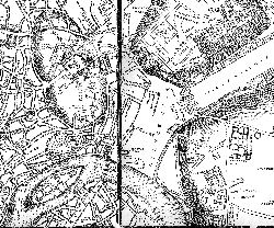
Figure 3: The Capitoline Hill, the Forum Holitorium and the Forum Boarium as shown in the map by L. Bufalini, 1551 (from Frutaz 1962, plates 202-203)
With a width of 30m, absolutely exceptional for the centre of Rome, the Via del Teatro di Marcello is the most striking sign of the demolition that took place in the interwar period between the Capitoline Hill, the Tiber and the church of S. Maria in Cosmedin. The work of 'isolamento' (isolation) of the Capitoline, as well as other massive interventions in the area, resulted in the almost complete destruction of one of the most important neighbourhoods in Rome. It was an area rich in memories and in picturesque corners, such as the piazzas d'Aracoeli, Montanara [map] and Bocca della Verità. Up until the 1900s, it had remained almost unchanged since the Renaissance, as attested by 16th-century maps. The 1551 plan of Rome by L. Bufalini (Figure 3) shows that, at that time, the neighbourhood of the Theatre of Marcellus [map] was already well developed and still showed traces of ancient roads. For instance, in the map, the road indicated as 'S. Maria de Porticu', next to the 'Piazza det(t)a Montanara' corresponds to a Roman road identified by some as the Via Triumphalis (Le Pera and Sasso D'Elia 1995, 67-70; for the triumph in general, Coarelli 1999a, 148). Similarly, the road indicated as 'T(emplum) Saturni' was equivalent to the ancient Vicus Jugarius (Virgili 2000, 169-70; on its modern re-creation, Romano nd, 129). Besides the church of S. Salvatore (later S. Omobono; Ramieri 2005a, 13-25), Bufalini also erroneously located the church of S. Maria in Portico. Several approaches to the Capitoline are indicated and the summit is shown in its pre-Michelangelo form.
Figure 3: The Capitoline Hill, the Forum Holitorium and the Forum Boarium as shown in the map by L. Bufalini, 1551 (from Frutaz 1962, plates 202-203)
In a more detailed map of 1576 by M. Cartaro (Frutaz 1962, pls 238-246), there is clearly a thicker fabric of buildings at the foot of the Capitoline Hill, near Piazza Montanara [map], the Theatre of Marcellus [map] and S. Maria in Portico. A similar situation (Figure 4) is attested in the map of E. Du Pérac (1577; Frutaz 1962, plate 250) while that of A. Tempesta from 1593 (Figure 5) is rich in realistic details, including the typical apse dome of S. Omobono.
Figure 4: The area between the Capitoline Hill and the church of S. Maria in Cosmedin in the map by E. Du Pérac, 1577 (from Frutaz 1962, plate 245)
Figure 5: The Capitoline Hill, Piazza Montanara and the church of S. Omobono in the map by A. Tempesta, 1693 (from Frutaz 1962, plates 266-267).
The 17th-century maps realistically portray the blocks and the roads. In the map by G.B. Falda (1676; Frutaz 1962, plate 362), again there is more settlement around the Capitoline Hill. Even more accurate proportions in the roads and piazzas can be observed in the 1748 map by G.B. Nolli (Figure 6), which clearly shows the survival of the medieval layout in the area. This last map is therefore a crucial document in order to understand the later changes in and around the Forum Boarium.
Figure 6: The Capitoline Hill, Via Tor de Specchi and Via Bocca della Verità in the map by G.B. Nolli, 1748 (from Frutaz 1962, plates 407, 410). Demolished buildings correspond to the following numbers on the map: 914 = S. Rita; 975 = S. Maria in vincis; 977 = S. Andrea in vincis; 981 = S. Orsola and S. Caterina; 1040 = S. Maria in Portico (S. Galla); 1052 = S. Aniano. [View static map]
One of the earliest interferences with the 'vecchi luoghi caratteristici' (old and picturesque places) in the area, deemed indispensable so that Rome 'potesse corrispondere meglio al nuovo compito di capitale del Regno d'Italia' (could be equal to its new role as capital of the Kingdom of Italy), was the demolition for the creation of the new river walls [map], which began in 1876. Muñoz described these walls as 'monotoni, per quanto necessari' (unexciting, if necessary) (1931). In the meantime, new master plans approved in 1873 and 1883 indicated the reorganisation of many areas of the city, but not the one in question. It was the master plan of 1909 that called for the demolition of the buildings located between the S. Maria in Aracoeli stairs and the monument to Victor Emmanuel, as well as for the 'isolation' of the Theatre of Marcellus [map] (Testa 1933, 327-55). In 1919, a Commission was appointed for the rearrangement of the Capitoline Hill. Chaired by R. Lanciani, with C. Ricci as vice-chair, the commission included many eminent scholars and professionals, such as G.B. Giovenale, M. Manfredi, A. Muñoz, R. Paribeni and P. Piacentini (Giovannoni 1920, 49-72). The 'isolation' of the hill was propounded again in 1925-1926, in a variant of the master-plan and fully undertaken with the advent of the Fascist regime, which acted on the plans drafted by the previous administrations. The political structure that was responsible for most of this work was the Governatorato (Governorship), which was created in 1925 (Regio Decreto, Legge 28 ottobre 1925, n. 1949) and reported directly to the Prime Minister. The governor was appointed by the king and had the same powers as the podestà (mayor) in other cities. There was also a vice-governor and the Consulta di Roma (Council of Rome), which had twelve councillors appointed by the Minister of Interior (Salvatori 2006, 24-28). The first governor, F. Cremonesi, was responsible for the administrative structure of the city.
The indefatigable and sole promoter and director of all these rapid transformations was Antonio Muñoz, who headed the Ufficio dei Monumenti di Roma (Office of the Monuments of Rome) in the Soprintendenza Statale (State Superintendence), and in March 1929 was put in charge of the Ripartizione Antichità e Belle Arti (Antiquities and Arts Division) of the Governatorato (Bellanca 2003, 17-19). From 1926, he started his work of 'liberazione' (freeing) of the Capitoline up to the stairs of S. Maria in Aracoeli, demolishing the houses in Via Giulio Romano and in 1928 the church of S. Rita [map] (Pietrangeli 1992, 86; Affanni 1995, 131-7; Lombardi 1996, 254-5). The 'recovery' of the Theatre of Marcellus also dates to 1926, entrusted to Alberto Calza Bini, who was the chairman of the Istituto Autonomo Case Popolari (Autonomous Agency for Council Housing). Six years later the theatre was inaugurated (Ciancio Rossetto 1995, 69-76; Ciancio Rossetto 2000, 31-5). It opened onto a new road, the Via del Mare, which, in the master plan of 1931 (Figure 7) was meant to be a new trunk road for the expanding city together with the Via dei Monti (Muñoz 1943, 8).
Figure 7: Master plan approved in 1931 for the reorganisation of the area (from Testa 1933, 346)
Demolition for the road involved the area around Via Tor de' Specchi, which was widened more than previously planned, and the churches of S. Orsola, S. Nicola de' Funari and S. Andrea in Mentuccia or in Vincis [map]. Here,
i tenui sacrifici che vi si dovettero fare, dal punto di vista dell'arte e delle memorie storiche con la demolizione delle due chiesette di S.Orsola e di S. Andrea in Vincis e di qualche modestissima fabbrica civile del Cinque e del Seicento furono largamente compensati dallo scoprimento del meraviglioso scenario delle Rupe Tarpea con lo sfondo del Teatro di Marcello (Muñoz 1943, 8; the real Tarpeian Rock is of course on the other side of the Capitoline) 'the tenuous sacrifices that were necessary, in terms of art and heritage, with the demolition of the little churches of S. Orsola and S. Andrea in Vincis and of a few very modest lay constructions of the 1500s and the 1600s, were amply compensated by the uncovering of the wonderful scenery of the Tarpeian Rock with the Theatre of Marcellus in the background'

Figure 8: Isolation of the Capitoline. Demolition of the houses on the western slope (AFSRCM)
After this extensive destruction, the rocky slope of the Capitoline (Figure 8) appeared
in più punti ben conservata; in altri tagliata e scalpellata per offrire pareti lisce di sfondo ai cortili delle case 'well preserved in many places; elsewhere it had been cut to provide a smooth back wall to the courtyards of houses'
The slope therefore had to be consolidated 'a terrazze e a scarpate arboree' (with wooded terraces and scarps) (Muñoz 1932b, 550; 1943, 8-9). During this work, completed in 1930 and extended to the Via del Mare, several archaeological remains were found, both near the Via delle Tre Pile [map] and east of the demolished church of S. Andrea in Vincis. Also on the western slope of the Capitoline, the demolition was going forward in Via Montanara, connected to Via di Monte Caprino through the Arch and the Via dei Saponari. The latter took its name from the guild of the soap-makers, whose church was there (S. Maria in Vincis [map]).
In 1929-30, the demolition reached Piazza Montanara,
'uno dei luoghi più pittoreschi della Roma dei tempi del Pinelli e del Belli, sopravvissuta intatta sino a noi' (Muñoz 1932a, 42) 'one of the most picturesque spots of Belli's and Pinelli's Rome, which has survived intact to our time'
Only a medieval house (also known as Casina dei Pierleoni) on Via della Bufala was spared, not so much for its architectural value as for its connecting function between the Capitoline and the Via del Mare (Motta 1995, 64). Much less attention was paid to the area of S.Nicola in Carcere [map], which was extensively transformed. In 1932, the first stretch of Via del Mare was completed, while in the following year the isolation of the Capitoline reached Piazza della Consolazione [map]. Subsequently, the southern side of Via della Consolazione was rearranged with the tearing down of the 'misere casupole che si allineavano con la chiesa di S. Omobono' (miserable hovels that were next to the church of S. Omobono) (Muñoz 1943, 20). For the completion of Via del Mare to the South, Via della Bocca della Verità had to be widened and the buildings opening onto it demolished (Figure 9; Muñoz 1932a, 35-6; this was an ancient road, see Cressedi 1984, 276, n. 40); for this reason, starting in 1935, there were extensive expropriations in the area. At the same time, A.M. Colini was exploring the subterranean area of the church and hospice of S. Galla [map], which were slated for destruction (Ramieri 2002a, 305). However, it was only when the area was levelled for the foundations of the new Records Office that the full extent of the archaeological remains were revealed.
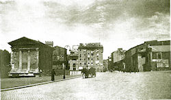
Figure 9: Northern side of the Via della Bocca della Verità (from Capitolium, IX, 1933, 341)
In 1936-37, the systematic demolition continued in the neighbourhood between Lungotevere dei Pierleoni and Via della Bocca della Verità, which was completely destroyed. Only the so-called house of the Pierleoni in Via del Ricovero (which a period photo shows completely isolated) and the house of the Crescenzi, restored in 1939 and connected to the Records Office in the following year, were left standing (Motta 1995, 65, fig. 7). At the same time, demolition was also moving on to the eastern side of Via del Mare, where all the blocks up to (and excluding) S. Giovanni Decollato were eliminated, together with the church of S. Aniano [map]. Other pre-modern buildings along Via Bucimazza [map], including a medieval tower, were also removed, together with the road itself. In this overall context of 'furia liberatrice' (liberating fury) must be placed the demolition in and around S. Omobono. The resulting general area was destined for the construction of new offices for the city, very similar to the Records Office; again, the problem of their connection with the adjacent ancient monuments presented itself. To address it, the medieval casa dei Pierleoni (which was the only survivor in its area) was demolished in 1936 and rebuilt in 1939 in the block between Via del Mare and Via S. Giovanni Decollato, facing Piazza Bocca della Verità and in correspondence with the casa dei Crescenzi (Motta 1995, 65; the church is identified as S. Maria de Gradellis in Lombardi 1996, 307, n. 28).
In the meantime, since 1924 work had been carried out by Muñoz at the Temple of Portunus [map], whose rearrangement was completed (Buzzetti 1999b, 153-6). Crucial for the final organisation of the area, however, was the visit Mussolini himself paid to the area between Via Tor de' Specchi and Piazza Bocca della Verità on October 28, 1929. He then had an opportunity to 'rimirare il brutto quadro di fatiscenti casupole' (contemplate the ugly picture of collapsing hovels) adjoining the monumental church of S. Maria in Cosmedin and the Round Temple (also known then as Temple of Vesta). He committed himself to the creation of a garden in place of the buildings between Via della Salara and the Lungotevere, which were qualified as
'informi baracche, degne sedi di depositi di legnami, di ferri vecchi e di una saccheria' 'shapeless huts, apt locations for timber and scrap metal warehouses and for a sack-maker'
Thus, only a few months later, 'il piccone demolitore cominciava la sua opera risanatrice' (the demolishing pickaxe began its reclamation work) in an area with valuable monuments, but dominated
'dal mulino e pastificio Pantanella con un'alta ciminiera laterizia, ed all'interno stalle, magazzini diruti, officine, mascalcie, miseri tuguri, asili di mendicanti' (Bianchi 1930, 573, 576, 578) 'by the mill and pasta factory of the Pantanella, with its high brick smokestack, and, inside, by stables, collapsed warehouses, workshops, blacksmiths, miserable hovels, beggars' shelters'
Actually, the reorganisation of the area had originally been entrusted to G. Giovannoni, whose blueprint had been included in the 1925-26 variant of the Master Plan (Giovannoni 1926-1927). Its main concept was the creation of an 'axis of symmetry' joining the centre of the Arch of Janus with the centre of the Temple of Vesta. Along this axis, the plan called for the creation of 'edifici di limitata mole e di sobria architettura' (sober and small buildings), as well as the restoration of existing ones, connecting them to the street level with gardens and terraces (Bianchi 1930, 579).
In 1926, work began on the demolition of the Cerchi hospice, a pavilion parallel to the Pantanella Mill [map], which had been purchased by the city to avoid private speculation and to help enact the Giovannoni plan (Bianchi 1930, 581). Three years later, Mussolini's intervention led to renewed action: by April 21, 1930 all the dilapidated constructions between Via della Salara and Lungotevere Aventino had been eliminated. By April 28, the Armenian Hospice had been subjected to the same fate (Bianchi 1930, 582, figs at 575; Gatti 1933, 278). Through this process of demolition, a unified 'archaeological platform' had been created, including the Arch of Janus, the Temple of Portunus and the so-called Temple of Vesta, later identified as that of Hercules Victor. The vast resulting area was connected to the higher Lungotevere by a grassy scarp and embellished by a geometric arrangement of flowerbeds and oleander trees according to a design by C. Busiri Vici (Figure 10; Bianchi 1930, plan at 584; in 2004, the design was arbitrarily altered by planting roses along the road).
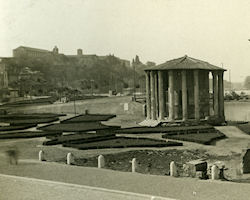
Figure 10: Redesign of Piazza della Bocca della Verità with the gardens behind the so-called Temple of Vesta (AFSRCM)
As elsewhere, vegetation was being used to connect the ancient monuments that had been singled out from their historical context. No attempt was made to harmonise them with the new constructions in Piazza Bocca della Verità, whose new arrangement was completed with the conversion of the Pantanella Mills into the planned Museums of Rome (Bianchi 1930, 584-7; Colini 1998, 68). Besides the Museo di Roma (Museum of Rome), the plan included also the Museo dell'Impero Romano (Museum of the Roman Empire), later changed to the actual Museo della Civiltà Romana (Museum of the Roman Civilisation) (Gallavotti Cavallero 1977, 104). The smokestack of the mill was eliminated, a small porch was added on and the façades were re-done, which resulted in archaeological discoveries. The 'quadro superbo' (superb picture) of Piazza Bocca della Verità was not essentially changed (Pasquarelli 1986, 68).
In 1941, the south-eastern slope of the Capitoline was isolated, bringing to light Republican-era terracing (Colini 1940c, 228), while the following year Muñoz finished his work on the southern slope of the hill, despite war-related difficulties. Here, the last remaining houses were torn down, along with the Corsia delle Donne, located in front of the Consolazione Hospital (Pietrangeli 1992, 79, 84). The nearby church of S. Lorenzo in Nicolacaso [map] (see Lanciani 1893-1901, plate 29) was also demolished, while the lowering of the street level by about 2.20m in the Via and Piazza della Consolazione [map] (Muñoz 1943, 43) resulted in additional archaeological discoveries. The street level was further lowered by the so-called Casina dei Pierleoni, requiring a rampart in front of it and the lowering of the porticus in peperino of Via della Bufala [map] to the level of the Via del Mare and of the Vico Jugario (Motta 1999, 158).
Another definitive intervention concerned the area to the north of the Theatre of Marcellus [map], which, after being 'liberated', was archaeologically investigated and found to contain a temple and other remains. Three columns from it were re-erected but not in their correct position, so that the view to the Porticus of Octavia, isolated in 1928-29, would not be blocked (Ciancio Rossetto 1995, 71; Viscogliosi 1999). In 1938, another temple, later identified as that of Bellona, was exposed in the same area. On part of the temple's porticus is the Albergo della Catena, a medieval building that was accurately preserved because it seemed to provide a good transition from the ancient monuments to the Baroque complex of the church and the convent of S. Maria in Campitelli (Triglia 1983). The Casina dei Vallati (Rossini 1995, 115-19), which had been restored in 1930 for the same reason as part of the Theatre of Marcellus complex, opened to the public on April 21, 1940 (Colini 1940a, 9).
In terms of publications, Lugli (1940, VIII-IX, 149-56) produced a clear synthesis of 'a decade of archaeological discoveries', meant to be a preliminary illustration of the monuments in the absence of scientific reports. Besides the non-specialist monographs published by the Governatorato, only short but timely reports published by Colini in the Notiziario (Brief Reports) of the Bullettino Comunale (the scholarly journal published by the city of Rome) were available, while the discoveries were quickly multiplying as a result of the fast and chaotic urban development. Inevitably, a lot of Roman and medieval archaeological evidence was destroyed without being recorded (see the Album delle demolizioni (Demolition records), preserved in the AFSRCM, except for n. 5/4). Photos of buildings and remains are rare and sometimes contain no indications of location. Only some marble artefacts, such as architectural pieces found reused in demolished churches and stored elsewhere, were photographed. Similarly, a large number of reliefs, inscriptions, and fragments of statues and early medieval carvings were stored in the arches of the Theatre of Marcellus and elsewhere (such was the case of the Apollo Sosianus pedimental sculptures; La Rocca 1985). No better was the fate of the Capitoline slope, where the excavated remains were left in underground chambers along the Via del Teatro di Marcello, invisible to the public.
However, to get a sense of the sheer amount of archaeological work carried out in this period, it is enough to browse through Colini's notebooks (La Rocca 1997-1998, 13-26), which contain measurements, sketches, plans, photos and newspaper cuttings. He clearly regretted the limited time allotted to his work, which was constrained by the inexorable sequence of inaugurations of renovated areas that were expected to take place every year on April 21 (the day of the foundation of Rome) and on October 28 (the date of the Fascist march on Rome). According to Colini, observing these deadlines sometimes led to 'decisioni affrettate' (rash decisions) that undermined the role of archaeologists in the process (Bellanca 1997-1998, 30). In the light of these observations, it cannot be said that 'gli sventramenti furono subordinati agli archeologi' (the demolition was controlled by the archaeologists) (Insolera 1971, 139) or that archaeology had an excessive role in the process (Gli anni del Governatorato, 5). The opposite seems true; archaeology was an excuse for urban devastation (Cederna 1980, 211). Colini emphasises the need to be
'tempestivamente informati dei progetti che il Governatorato si appresta a svolgere per poter conseguentemente disporre i provvedimenti necessari di interesse artistico e archeologico. Ancor più utile sarebbe esse informati della elaborazione dei progetti stessi per poter far presenti le necessità suddette ed orientarli' (Colini 2000, 21) 'informed in a timely manner of the projects that the Governorship proposes to carry out so that the necessary interventions for art and archaeology can be undertaken. It would be even better if one could be informed of the planning process itself so that the above-mentioned needs could be highlighted, providing direction at the planning stage'
© Internet Archaeology/Author(s)
University of York legal statements | Terms and Conditions
| File last updated: Mon Mar 12 2012
)
)
)
)
)
)
)
)
)
)
)
)
)
)
)
)
)
)
)
)
)
)
)
)
)
)
)
)
)
)
)
)
)
)
)
)
)
)
)
)