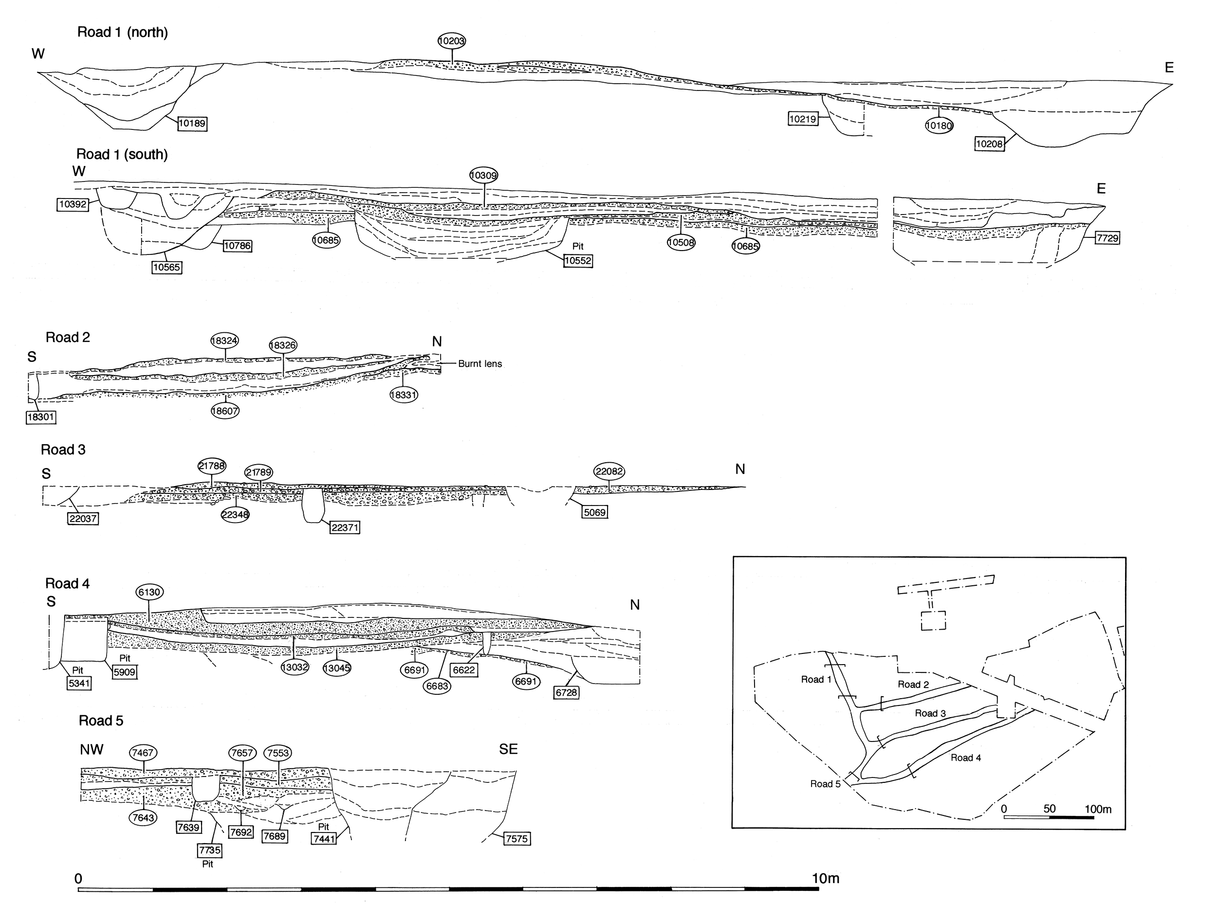
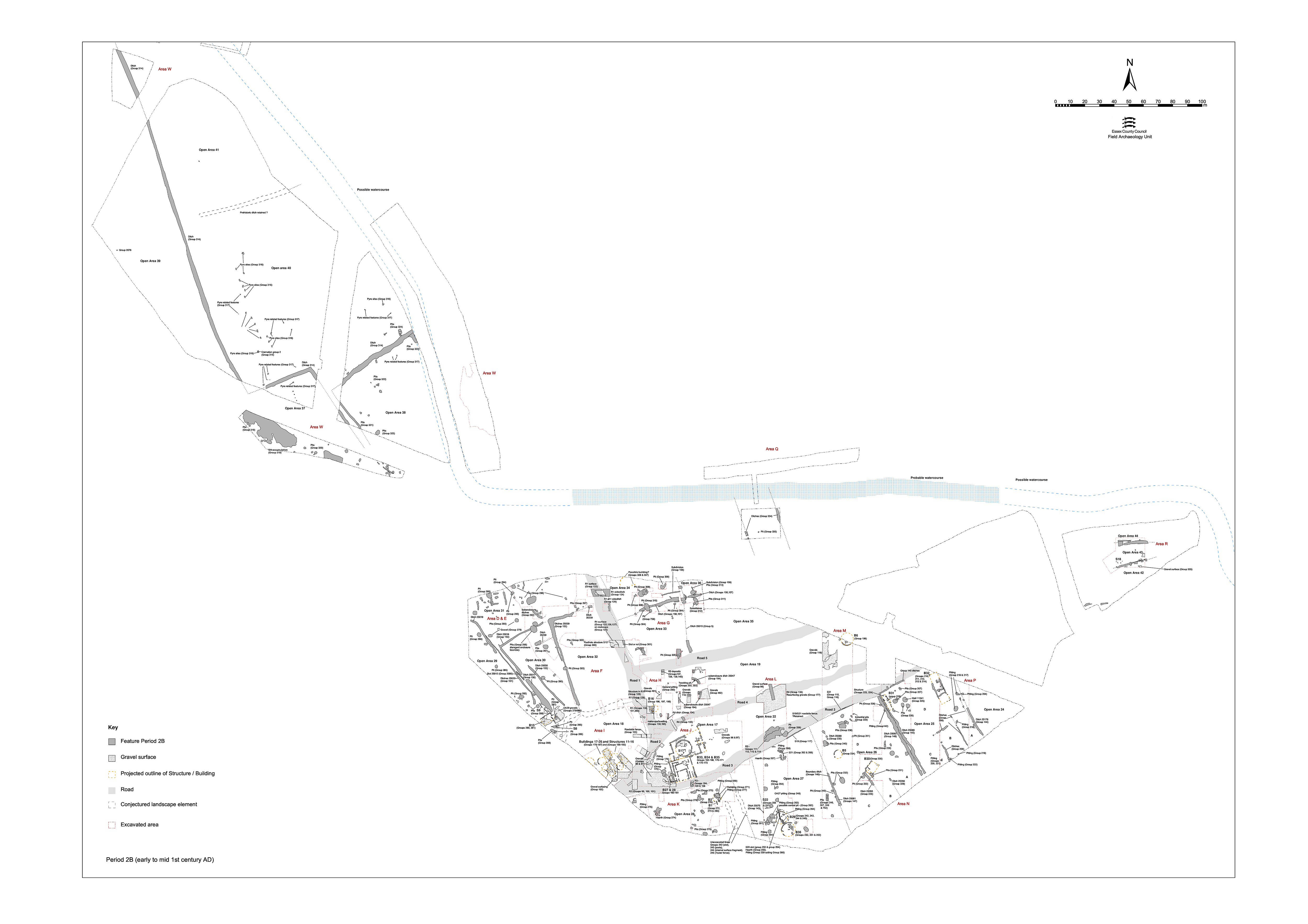
Road 1 (Figures 6 and 58), along with Roads 2-5 is imposed upon the lower terrace as part of a major settlement remodelling episode that takes place around the time of the Roman Conquest and which marks a watershed between Period 2A and Period 2B occupation, see the following:
The original topsoil appears to have been deliberately removed, with the road constructed directly upon the exposed natural gravels. This forms the principal north-south route through the settlement area. At its southern end, the road clearly changes course to avoid the religious focus. Whether this respects the site of the former Period 2 shrines, or indicates that the replacement temple is already in place, is uncertain. Its south-westerly continuation (toward a presumed crossing of the River Chelmer) is termed Road 2.
The earliest surface of Road 1 was recorded in limited areas over much of its length. From its inception, the road is of solid and relatively sophisticated construction, formed from compacted gravel surfaces laid on top of redeposited brickearth make-ups and accompanied by an eastern side-ditch along the Open Area 33 frontage (Excavation Area G). The various investigated parts of this earliest phase of Road 1 are described from north to south.
Where investigated within the Area F 'Haul Road Trench', compacted gravel deposits 10217 and 10708 (Group 122) constitute the primary road surface that is recorded over a distance of c. 75m. These surfacing deposits are between 0.07-0.12m thick, over 4.15m wide, and include sparse bodysherds in both grog-tempered and Roman fabrics.
Patches of clayey sand layers (Group 125) overlie the road. The most substantial of these is 10204, found to be 3.0m wide, though truncated along its western edge by Period 3 ditch 10189 (Group 360). All comprised dirty brickearth containing residual prehistoric material, and they are interpreted as foundation deposits of redeposited material for the overlying gravel surfaces. Above these were patches of bonded gravel surface 10209, 10225, 10210 and 10228 (Group 126), cumulatively amounting to a 3-5m wide expanse and displaying a cambered surface on the east side. These road surfaces were truncated along both edges and may originally have been up to 6m wide.
Very little artefactual material, other than residual prehistoric pottery and worked flint, was collected from any of these deposits. This may help to emphasise the relatively early construction date of this road, but equally may simply reflect the use of 'clean' construction materials. Underlying foundation deposit 10213 does, however, contain an early 1st-century BC coin (SF2220), though the road is unlikely to be quite this early.
Above the gravel surface, a number of features represent the use, wear and repair of the road (Groups 129, 301). Of note are narrow, shallow slots 10549 and 10684 (Group 301), that run roughly parallel, 2.7m apart, on a NW-SE alignment across Road 1. These may represent wheel ruts in the road surface, as their alignment differs slightly to that of the adjacent roadside ditch. All datable material from these features is Late Iron Age. They are sealed by the succeeding Period 2B metalled surface 10556 (Group 126). Other features on the road include subsidence hollows, which develop owing to the numerous underlying features, accumulated silt deposits (e.g. 10543) and road repairs, and total a maximum of 0.17m in thickness. Post-holes and/or small pits 6808, 10705 and 10707 (Group 128) interleave with these deposits and cut into the road surface below.
Structure 10, a slightly more tangible and more evidently structural line of seven post-holes (Group 300, 10677, 10679, 10681, 10738, 10740, 10753, 10755) cuts the earliest road surface in the Area F 'southern trench', running at a slight tangent across much of its width. There is some variation in both size and spacing of the component, though also a degree of patterning of two smaller post-holes between each larger one. Further post-holes with a similar stratigraphic position were present but displayed no patterning.
Although not readily interpretable within the limited extents of investigation, these features at least indicate a degree of encroachment and demonstrate that even in its earliest inception this principal route was not sacrosanct.
Where investigated within Excavation Area H, toward the Road 1/4 junction, gravel deposits 6611 and 6661 (Group 131) form the earliest coherent surface of Road 1. The road surface is laid upon redeposited brickearth levelling layers or foundation deposits, 6676 and 6773 (Group 130), which seal the Period 2A water-hole 6734 (Group 67) and its adjacent surface 6793. The actual road surfaces are 0.12m-thick deposits of compacted and bonded gravel. As recorded, surface 6611 overlies the edge of 6661, perhaps hinting that the road is constructed in sections from north to south. Alternatively, this impression of two distinct surfaces may simply be created by the slumping of 6661, and of the brickearth foundation deposits below, into water-hole 6734. The road foundation deposits contain a relatively large assemblage of undiagnostic Late Iron Age pottery, while surface 6611 also includes an Italian amphora spike.
Overlying silt 6451(Group 132) presumably represents the use of this road. A further sandy silt deposit 6450 (Group 363) accumulates in the hollow formed by road surface 6661 subsiding into underlying water hole 6734.
Linear cuts 25038 (segs 10219, 10631) and 25242 (segs 10546, 10582) run NNW-SSE down the eastern side of Road 1 and probably represent a single roadside ditch that can thus be intermittently traced for at least 45m within Excavation Area G. Surviving to a width of 2.0-2.5m and a depth of 0.4-0.5m, it terminates c. 10m north of the Road 1/5 junction. Toward its northern recorded extent, ditch 25038 is sealed by road surface 10180 (Group 352) and truncated by replacement ditch 25246 (Group 354), both of Period 3 date. Ditch 25242 appears to cut the eastern edge of the contemporary road surface.
It is re-cut by ditch 10582, which contains sandy clay fills possibly derived from adjacent road make-up layers. It is likely that this ditch is an addition, inserted alongside Road 1. It is maintained and continues to function into the early Roman period; re-cut segment 10582 contains a Late Iron Age primary fill with late 1st-century AD Roman material above. Indeed, elsewhere in Area G, gravelly silt roadwash deposits 6300 and 7590 (Group 123) accumulate along the east side of the road and similarly indicate continuing use of the thoroughfare into the early Roman period.
Internet Archaeology is an open access journal based in the Department of Archaeology, University of York. Except where otherwise noted, content from this work may be used under the terms of the Creative Commons Attribution 3.0 (CC BY) Unported licence, which permits unrestricted use, distribution, and reproduction in any medium, provided that attribution to the author(s), the title of the work, the Internet Archaeology journal and the relevant URL/DOI are given.
Terms and Conditions | Legal Statements | Privacy Policy | Cookies Policy | Citing Internet Archaeology
Internet Archaeology content is preserved for the long term with the Archaeology Data Service (ROR). Help sustain and support open access publication by donating to our Open Access Archaeology Fund.