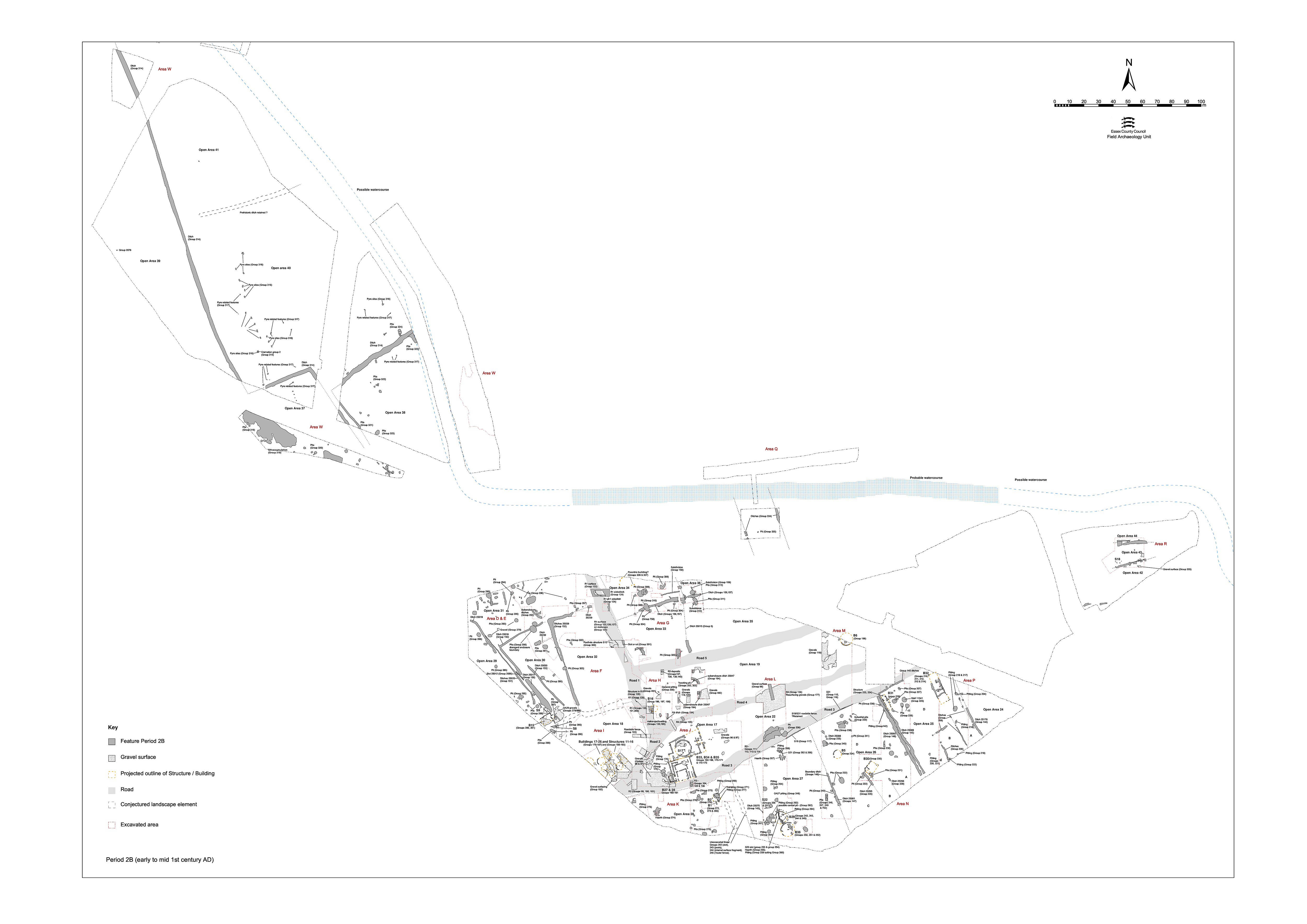
Around the middle of the 1st century AD a coherent pattern of roads and enclosures is imposed across the lower terrace and the field systems on the upper terrace remodelled (Figure 6). The evidence for the nature of any continuity of occupation is difficult to discern. However, previously described destruction deposits, tentatively related to the clearance of the Period 2A religious focus in OA2, would tend to suggest that there is no significant hiatus between Periods 2A and 2B. The initial process of settlement transformation appears to be undertaken in one widespread and rapid episode and can therefore confidently be regarded as marking the start of Period 2B. That this remodelling coincides with the period of transition between LPRIA and Roman occupation, which occurs in the few decades either side of the Claudian Conquest of Britain, is of particular interest and significance - particularly given the settlement's location on the south-east coast and in near proximity to Camulodunum. The further connotations and implications of this remodelling and of the assumptions underpinning its execution in terms of construction, wealth, status, etc., are considered in Volume 1 (Atkinson and Preston 2015, Chapters 4 and 5).
It is clear that the excavated Period 2B remains (and for that matter those of succeeding Periods 3 to 5) constitute only the eastern periphery of the settlement core and its outlying areas. As discussed in Volume 1, the majority of the settlement almost certainly lies alongside the south-westward continuation of the road infrastructure heading toward a crossing of the River Chelmer. It should therefore be borne in mind during the ensuing discussion that the entire area of the site forms the eastern and north-eastern littoral of settlement and does not define the morphology of the settlement proper. However, enough of the settlement area has been investigated to study the nature of this critical episode of change from the edge of its core, peripheries and surrounding immediate hinterland.
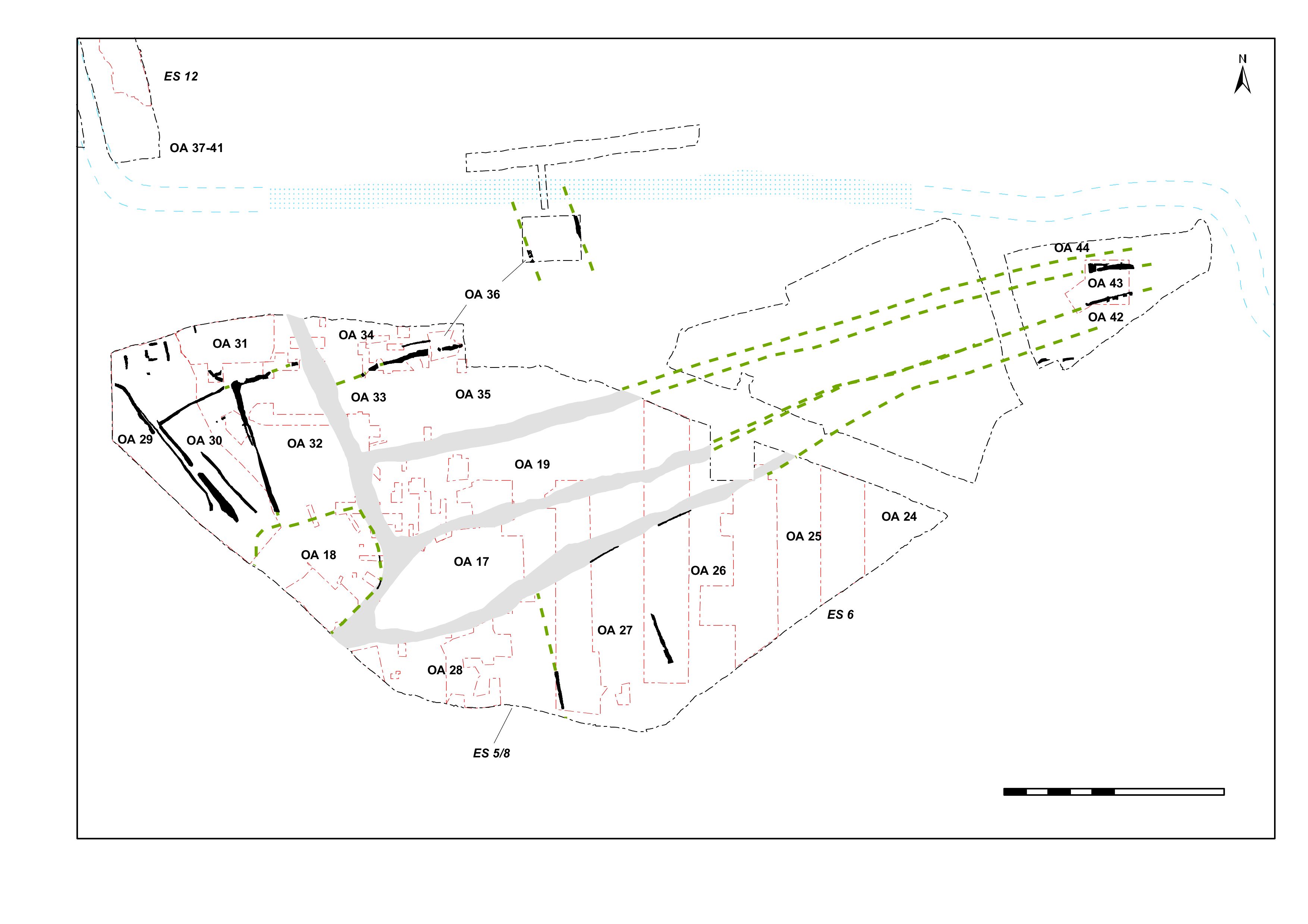
The defining element of Period 2B is the creation of a road network (Figure 31, marked in grey), which gives clear shape to the settlement and subdivides it into subsidiary areas. Roads 1 and 2 define the principal route, which runs from the river crossing, through the settlement core that lies to the south-west of the Elms Farm site before turning northwards, from which three subsidiary east-west routes branch (Roads 3, 4 and 5) and are conjectured to merge as they exit the eastern settlement limit. The imposition of the road network appears to be a single event and to have been closely associated with the construction of extensive gravelled areas extending east-west across the middle of the lower terrace. The gravels of the roads and adjacent open areas are generally laid directly upon clean, natural deposits and there is a strong suggestion that widespread site preparation, involving topsoil removal and ground reduction/levelling of the undulating terrace, preceded the formation of the surfaces.
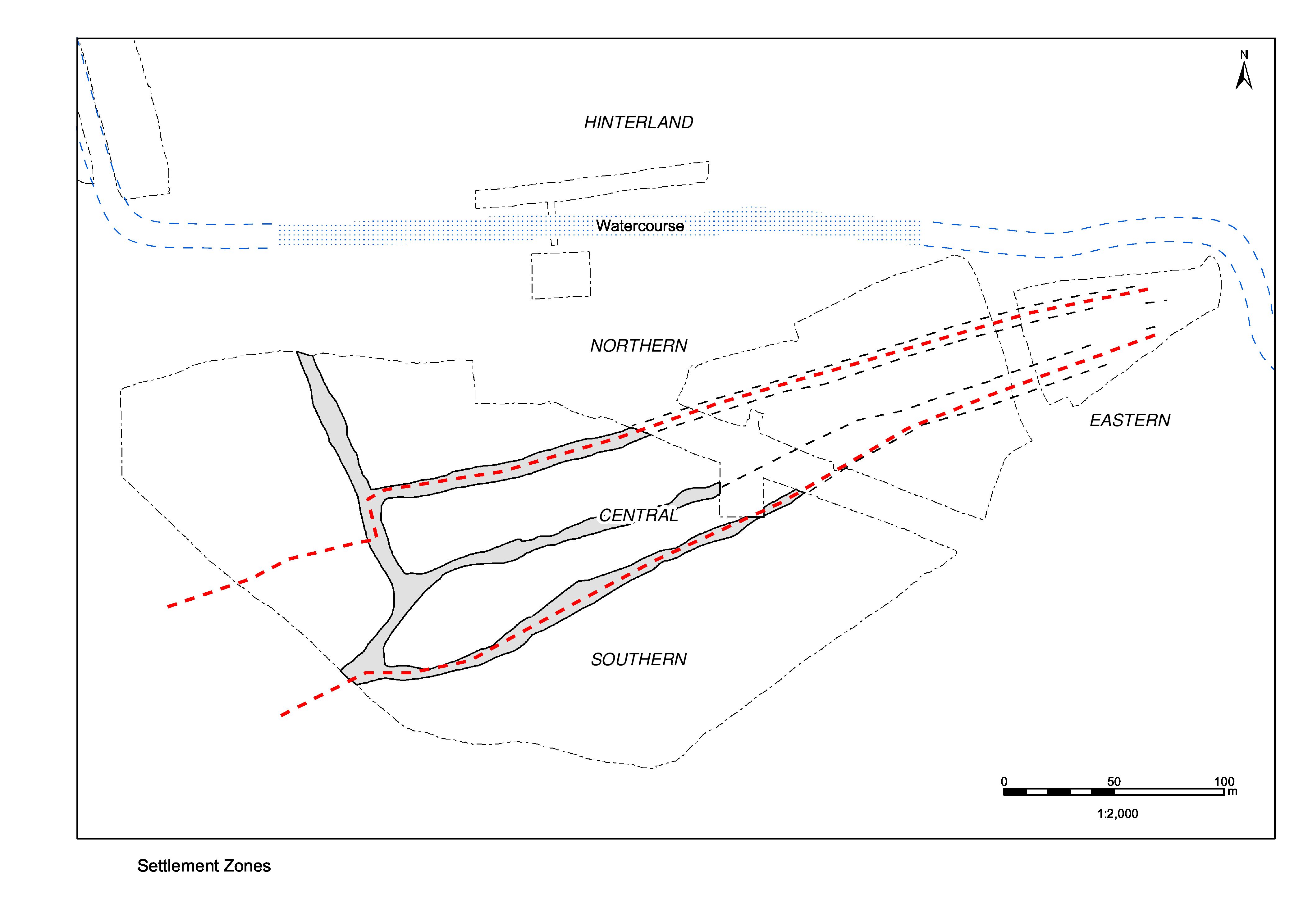
Collectively, the roads and the land entities that they delimit define a band of gravel surfacing that extends east-west across much of the middle of the lower terrace. Effectively, this serves to divide the terrace into three broad morphological and functional zones - in essence, the central area was surfaced, and the northern and southern zones either side were not (Figure 32). For ease of reference, as much as upon real morphological criteria, this zonal perception of the site has been extended to the whole excavation area, with the inclusion of the landscape of the upper terrace (northern hinterland) and eastern periphery (eastern hinterland) as further such entities. Reference is made to these five 'settlement zones' throughout the remainder of this site narrative.
As outlined earlier, the Period 2B reorganisation of the settlement is profound and widespread, though by no means uniform across the investigated landscape.
The component parts of the restructuring comprise:
It should be noted that some threads of likely continuity can be tentatively identified amid the extensive change wrought across the lower terrace. It seems probable that some boundaries may be retained, though it is more difficult to ascertain whether or not Period 2A buildings endure into this Late Iron Age/early Roman transition period. Examples of probable continuity and survival are alluded to as appropriate below.
As previously mentioned in the introduction to the site narrative, the imposition of this new settlement infrastructure, together with the different character of the land-use and activities apparent within its different parts, means that distinct functional 'zones' can be discerned across the settlement. While these are created in Period 2A, they remain largely relevant throughout the settlement's life. The zones comprise:
The creation of the road network (Roads 1-5), and of the extensive gravelled areas in the centre of the site (Open Areas 17, 18, 19), appear to be closely related events. Where excavation removed the road and enclosure interior surfaces, they were found to be constructed directly on natural sand and gravel. Disturbance of the underlying natural surface was also noted. This, together with the absence of any trace of remnant land surface or soils, indicates that the restructuring episode was a massive one, involving clearance of pre-existing structures, removal of topsoil, infill and consolidation of earlier features, and importation of presumably quarried gravels.
Although it was only selectively excavated, much of the road layout could be clearly observed as distinct linear gravel deposits running across the lower terrace. Roads 1 and 2 define the principal route through the settlement, broadly speaking defining a north-south axis that curves to the south-west toward a crossing of the River Chelmer. Roads 3, 4 and 5 constitute three subsidiary 'side' routes that extend eastwards from this main axis. While they are regularly spaced from one another as they emerge from Roads 1 and 2, it is evident that they gradually come together and are conjectured to merge in the vicinity of Excavation Area Q as they exit the eastern settlement limit and probably cross the curving watercourse just beyond.
Cumulatively, the dating evidence suggests that the creation of this new settlement infrastructure occurs in the mid-1st century AD. A number of pits (Groups 88, 89, 90, 91, 92, 93, 94, 141) and ambiguous, often gravelly, deposits are either sealed by the road gravels of Roads 2 or 3 or lie within the continued unsurfaced road line as defined by fences Structures 19/31 (Group 110). It is unclear whether the earliest gravels on the line of Road 3 (Groups 107, 108, 109) actually represent a road surface. These deposits were certainly encroached upon by pitting, at least suggesting that initially there was no fixed route. It is possible that the more easterly parts of Roads 3 and 4 were initially trampled tracks across the general gravel surfacing of the open areas. Samian pottery from some of these early gravel deposits (Group 107) and encroaching pits (Group 91) provides a terminus post quem of AD 40. Other features contained fragments of brick/tile and Romanising greyware. The available dating evidence cumulatively suggests a transitional, mid-1st century AD date.
It is difficult to determine whether any remains of the earliest phase of Road 1 to the south of its junction with Road 5 survive. However, gravel surfaces (Group 122) are recorded over a distance of c. 75m to the north of this. Roman fabrics are present in the road deposits. Although the first road is solidly built and c. 7.4m wide, it seems to be encroached upon for a time by post-hole structures such as Structure 10 (Group 300 and possibly Group 301), which could suggest that this earliest road is uncertain or ill-defined for a time.
Within the Northern Zone, only one Road 1 surface (Group 131) and its underlying make-up (Group 130) is extant from this period, along the edge of OA19, and it is unclear whether this represents the primary surface or not. Micromorphological analysis of the soil of 6676 (Group 130) has identified characteristics in common with an in situ beaten floor, probably of more than one phase. This suggests that the redeposited brickearth may have been used as a surface in its own right or else is the product of reworking by animal activity - either way, it perhaps marks a transitional stage of land-use between Period 2A and the subsequent reorganisation in Period 2B. The Group 130 road make-up deposits in turn seal the make-ups for Building 16 (Group 195) and extend into the interior of OA19. Road 1 continues to subside into the underlying Waterhole 6734 (Group 67 Period 2A), and brown silts (Group 363) accumulate within the hollow so formed.
Post-hole 6808 (Group 128) cuts the Group 130 road make-ups but is sealed by the road surface Group 131. The road surface, as investigated, is constructed of two, 0.12m-thick, overlapping deposits of compacted and bonded gravel. As recorded, surface 6611 (Group 131) overlay the edge of surface 6661 (Group 130), perhaps hinting that the road was constructed in sections from north to south. Alternatively, this impression of two distinct surfaces may have been created by the slumping of 6661, and of the brickearth foundation deposits below, into Waterhole 6734. Use deposits (Group 132) overlay the road surface and accumulated in the subsidence hollow over the waterhole. The road foundation deposits contained a relatively large assemblage of undiagnostic Late Iron Age pottery, while surface 6611 contained an Italian amphora spike. Residual material such as worked flint and residual prehistoric pottery was also retrieved. This helps to emphasise the possible pre-Roman construction date of this road.
Make-up deposits (Group 125) overlay this earliest phase of Road 1 material (a residual early 1st century BC coin - SF2220 - came from 10213) and were in turn sealed by a replacement surface (Groups 126, 127), which is represented by gravel deposits observed at a number of locations along the road's length over a distance stretching 109m north from the junction of Roads 1 and 4. Patches of bonded gravel surface such as 10209, 10210 and 10228 cumulatively demonstrated that the road remained at least 5.00m wide and the encroachments on to the Phase 1 road surface were sealed over.
Silty accumulations and possible patchy repairs (Group 129) mark the use of this surface, together with successive post-holes (Group 128) that might denote roadside structures but are too sparse to be interpreted. The Phase 1 eastern side ditch 25038/25342 initially remained in use with this new surface but one of its fills (10225) may suggest that it started to silt up during the lifetime of the Phase 2 surface.
The contemporary side-ditch (Group 124) down the eastern side of the road appeared to cut the Group 122 surface. Though recorded intermittently, it is likely to represent a single roadside ditch extending for at least 50m. It survived to a width of 2.0-2.5m and a depth of 0.4-0.55m. A re-cut in the top of the ditch (10582) contained sandy clay fills possibly derived from adjacent road make-up layers, but the dating of the fills of this feature (Late Iron Age primary fill with late 1st century Roman material above) suggests that the roadside ditch was maintained and continued to function into the early Roman period. The width of Road 1 between this side ditch and the probable line of any western counterpart (which is assumed to be duplicated by the line of ditch Group 360 in Period 3) would have been c. 7.4m.
The earliest recognised make-ups or metalling at the junction of Roads 2 and 3 (Groups 99, 100, 101) overlie pit 14057 (Group 92), which is dated to the LIA/Roman transition. Pottery collected from the surface itself concords with this date. The Road 2 surfacing merges with gravel surfacing across the interior of adjacent enclosure OA18, indicating that they are laid more or less simultaneously.
About 40m to the east of its junction with Road 2, Road 3 is defined by a sequence of make-up, surface and use deposits (Groups 104, 105, 106) that overlie deposits apparently post-dating AD 40 (Group 107). The road is probably c. 5m wide at this point and is not flanked by any ditch. At a Road 3 sequence recorded further east (Groups 111, 112, 113, 114) stratigraphic relationships and the presence of Romanising wares within the road deposits again indicate a mid-1st century AD date. No surfacing is evident any further east than Excavation Area L. However, its continuation is signalled by its demarcation by fence-lines along the frontages of the Southern Zone enclosures of Period 2B date. This less formal nature of much, if not all, of this 'side' road is also demonstrated by the lack of flanking ditches to either side and the encroachment of pitting, apparently soon after its inception.
Excavation just east of its junction with Road 1 defines Road 4 as a 4m-wide, cambered gravel surface (Group 133) flanked by a northern roadside ditch (Group 134), which accumulates later 1st century AD material in its upper fills. An early resurfacing episode (Group 135) is tentatively identified. Like Road 3, there is no evidence of its surfacing beyond Excavation Area L.
The northernmost of the three 'side' roads, the earliest evidence for Road 5 is represented by sandy make-ups (Group 137) sealed by a compact gravel surface (Group 138) and evidence for its wear (Group 139). This sequence is sealed by deposits dated to the later 1st century AD.
The creation of the road infrastructure is accompanied by the surfacing of large areas of the lower terrace in close association with it. Roads 3 and 5 can be construed to mark the southern and northern extents of this and, collectively, the roads and gravel surfaces therefore serve to define a broad band of redeposited gravels that runs east-west along the middle of the lower terrace and can be seen to continue west of Road 1. For ease of reference, as much as reflecting a real morphological difference with other parts of the site, this is termed the 'Central Zone' from here on. As such, Road 1 is the only one judged to extend beyond the limits of this Central Zone.
The Central Zone, itself an entity with a distinctive character, comprises three discrete areas (Open Areas 17-19) largely bounded by roads. The remodelling of the settlement and the creation of these entities has been previously described. Once established, these open areas appear to be accorded specific functions - predominantly as public spaces - and are rapidly developed as such. The evidence for their occupation and use is described below.
Open Area 17 is an elongated, curiously irregularly shaped, tapering enclosure formed and bounded by Roads 2, 3 and 4. The vicinity is subject to the widespread ground preparation that is presumed to be carried out across the whole extent of the Central Zone prior to the imposition of this new settlement infrastructure. The Period 2A shrines (Buildings 7 and 8) are cleared and destruction deposits used to infill open pits and generally create a level surface (Group 96). Either simultaneous with road construction, or else immediately following, a gravel surface (Groups 97, 98) is laid down across the enclosure interior, presumably covering the site of the former shrines.
It is perhaps pertinent to note the absence of features marking boundaries to this enclosure. The term 'open area' is perhaps most apposite here, with the lack of roadside ditches or fences evidently allowing free access.
Although the Period 2A activity, comprising the probable shrines (Buildings 7 and 8), and the other structures and features surrounding them, is cleared to allow the formation of the gravel-surfaced OA17, the religious function of this location seems to be immediately re-established. A series of structural features seem to indicate the construction of a preliminary and short-lived building (or buildings) set within the gravelled area, alongside Road 3. The certain remains of Building 27 comprise slot 25064 (Group 160), which defines three sides of a small structure, probably square and some 4.5m across. Any trace of the eastern wall of Building 27 is subsequently truncated by later Period 2B Building 33. Second slot 25066, of similar proportions, lies just to its north. This curving length of foundation could constitute the north-eastern corner of the same building. Alternatively, combined with slot 25067 (Group 161), it could be construed to form a second phase of sub-rectangular building measuring some 8.0m by 5.0m - Building 28. Whether these slots are beam-slots, drip-, or drainage gullies is uncertain. Buildings 27 and 28 may be no more than purely temporary or interim structures.
They are evidently short-lived and are cleared in their turn to make way for a redesigned religious focus comprising two major buildings (Buildings 33 and 34/35) that are constructed on the OA17 gravel surface. These new buildings are sited directly over, and centred upon, the earlier structures (e.g. Building 33 over Building 8), which implies a deliberate attempt at continuity and/or continuance of the special significance of this location.
The foundations of Building 33 (Figure 33), surviving as four sets of intermittent rectilinear slots (Groups 162, 163, 165, 167), define a structure that is c. 15m square. The slots also form a series of 'concentric' spaces within the building, except on its south side where a single foundation runs along the edge of Road 3. Because all the foundation slots are of a generally similar dimension (c. 0.30m wide and 0.25m deep) and contain similar fills, they are interpreted as belonging to a single building phase rather than representing successive enlargements or replacements. Post-holes (Groups 164, 166, 168), apparently integral, occur within the lengths of slot. Some of these post-holes are located at the terminals of slots and suggest that at least some of these gaps in the foundation are deliberate, rather than the result of truncation. The slots on the east side of the building are more interrupted and may hint at the position of doorways.
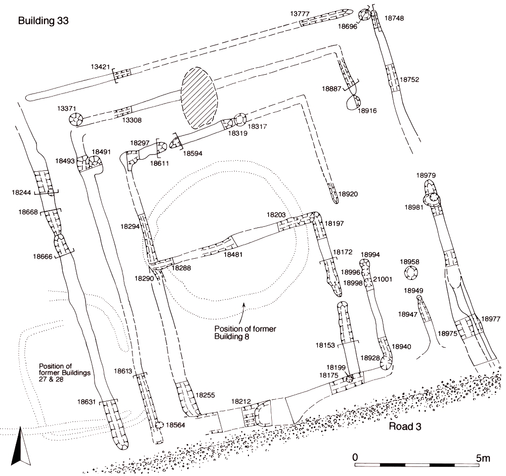
At the centre of the structure, the foundation slots define a 'room' some 6.70m square. Further post-holes (Group 169) occur within the interior of the innermost, square, 'room'. These tend to be of small size and are often positioned in pairs around the walls of the 'room'. This apparent patterning may be a result of differential survival or could hint at an internal structure. The 'concentric' nature of the layout of the building's interior suggests that the internal walls form either an ambulatory around a central chamber, or even a small labyrinth around this focal point. The sacred nature of this building is substantiated by its deliberate centring over Building 8 and by the fact that the inner 'rooms' of Building 33 are of identical width as the underlying shrine remains.
Building 34 (Figure 34) is defined by a substantial (0.4m wide x 0.3m deep), circular slot 25057 (Group 170) and associated post-holes (Group 171). Approximately 11m in diameter, the west side of the building is truncated. A genuine break in the foundation marks a c. 2m-wide entrance facing roughly east-north-east. The identification of this structure as a Romano-Celtic temple cella relies solely upon morphology, along with the strength of cumulative evidence of both preceding and succeeding periods, rather than upon distinctive architecture or any directly associated artefactual evidence. As Building 34 is centred on much the same spot as Building 9 (Period 2A) it is likely to be intended as a larger replacement for it. However, it should be borne in mind that the earlier building is a tentative interpretation of a post-hole grouping. A clustering of post-holes within the building - Structure 17 (Group 174) (Figure 34) - might denote a structure, possibly a shrine, at the rear (west side) of the cella interior. There is, however, an absence of substantial post settings within the building and there is no substantive evidence that it is roofed.
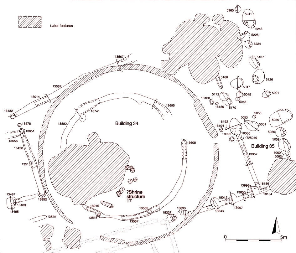
Most of Building 35 (Figure 34), as defined by slot foundations (Groups 172, 173), probably amounts to little more than a screening wall or fence defining a trapezoidal-shaped enclosure around Building 34. The exception is its eastern frontage. Here, a c. 2m-wide entrance is located in the middle of a 16m-long frontage and a line of large post-holes, offset from the building-proper by some 3.5m, probably define a façade or portico. Building 35 incorporates the north wall of Building 33 into its plan, to which it appears to have been added. A less elaborate rear entrance to the trapezoid enclosure, marked by slot 25125 (Group 172) on its western side, is also posited.
Buildings 34 and 35 are therefore best considered as elements of the same overall structure, the only part of which to be roofed is probably the ornate eastern frontage of Building 35, where two rooms may flank the central entrance passage through the façade. The elaborate temple frontage both provides access and creates a barrier to those approaching from the east. These buildings are only the first elements of a religious complex that continues to develop in Period 3.
The temple precinct (Figure 35) around Buildings 33, 34 and 35 occupies the entire width of the plot between Roads 3 and 4, while Road 2 marks its western extent. There is no contemporary evidence of boundary ditches or fences, but it is possible that the line of precinct boundary Structure 39 (removed in Period 3B) has its origins in Period 2B and that this line marks the original eastern limit of the precinct. However, this cannot be demonstrated to be the case until Period 3.
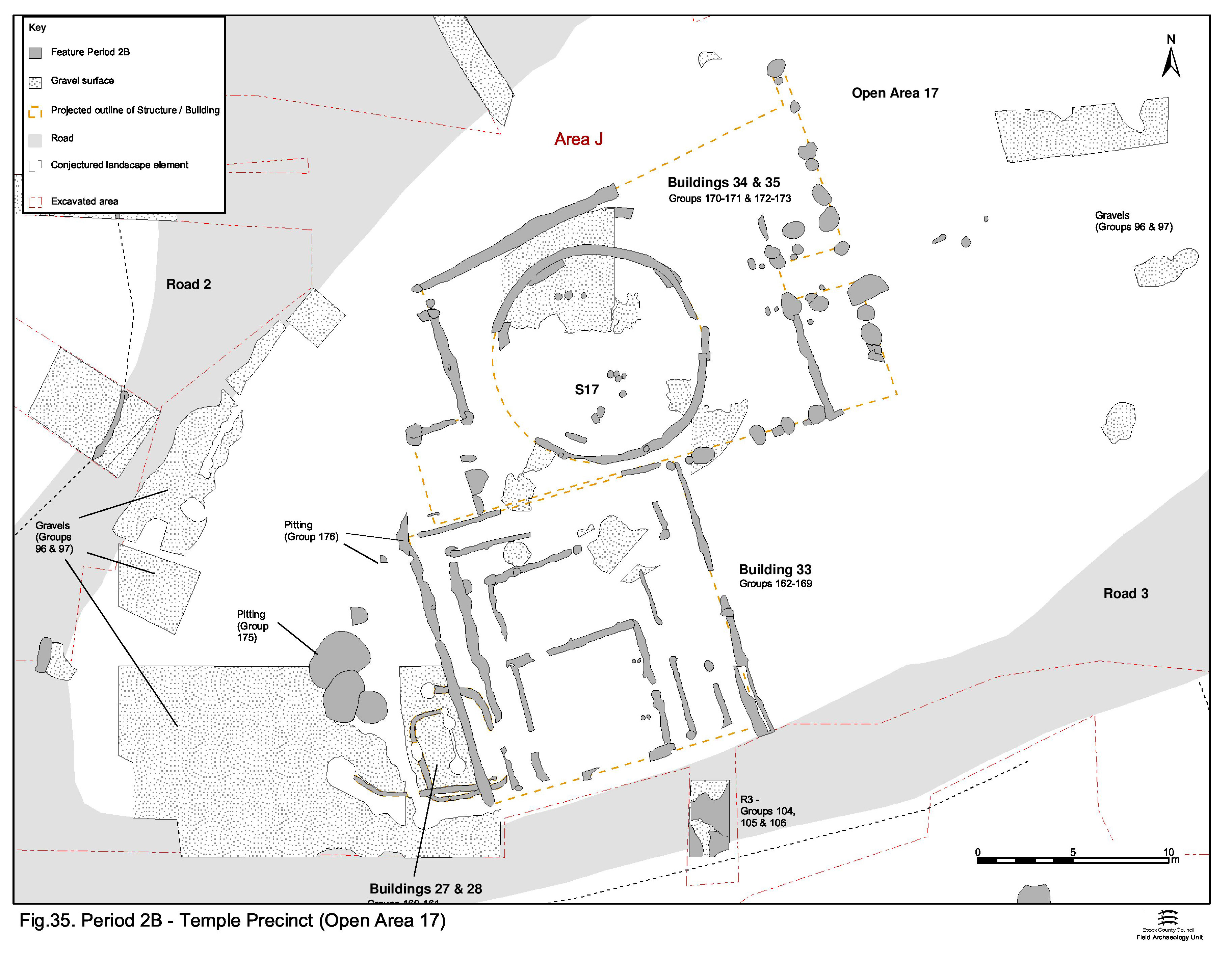
That part of OA17 to the rear (west) of Building 33 may function as a 'backyard' area. Pitting here (Group 175) seems to be created for domestic rubbish disposal, as no ritual deposition can be demonstrated. Other than a number of iron objects and a La Tène III brooch (SF4747) in pit 13560 (Group 175), there is a relative lack of artefacts such as coins and other metalwork across the religious complex. Pit 13893 (Group 176) must have a relationship with Building 33, though this is unfortunately undetermined. The pottery, including Samian, and other finds are all consistent with a mid-1st century AD date for the infilling of these pits.
It is notable that no Period 2B features occupy that part of Open Area 17 between the temple building frontage and the later precinct wall.
Further discussion of the temple complex is presented in Volume 1 (Atkinson and Preston 2015, Chapter 6). Parallels with other LIA shrine/temples such as at Hayling Island, Fison Way and perhaps Frilford, are noted.
Although at least notionally distinct from the west end, the use of the eastern part of OA17 should be regarded as being closely linked with the emergent religious complex. Indeed, it remains entirely possible that there is no formal separation between them during this period. Activity to the east of the temple building complex seems to be confined to gravel resurfacing (Group 177) that seals a resurfacing of Road 4 (Group 136) and extends southwards into the interior of the plot. Though unproven by excavation, it is likely that this surface originally covered much, if not all, the area between Roads 3 and 4. The indistinct nature of the gravels within the plot and those forming Road 4 surfaces reinforces the notion that, this far east, Road 4 may be more of a routeway through the flanking gravelled open areas either side. Devoid of either structures or pits of Period 2B date, OA22 may be regarded as constituting an actively maintained public open space in front of, and associated with, the temple complex. As previously noted, the lack of boundaries here strongly suggests a high degree of permeability into this open space.
Immediately to the north of the temple complex, Road 4 undergoes a major resurfacing (Group 135). The northern extent of this surface is unknown as it is truncated by a later roadside ditch (25254 Group 379 Period 3), but a northwards shift or general widening of the road is suggested. The dating is poor; the surfaces contain a single tiny sherd of Romanising greyware, which scarcely constitutes a secure basis for dating. The next surface above it dated to the late 1st century (Period 3).
Although extending beyond the site limit, Open Area 18 is believed to be a vaguely square enclosure, bounded on its east and south sides by Roads 1 and 2, respectively. Although its interior was by no means fully excavated, it is apparent that it is similarly cleared of topsoil down onto underlying natural gravel - the surface of which was observed to be disturbed and rutted before being covered with a surface of graded and compacted gravel (Group 102). The frontage along Roads 1 and 2 is demarcated by a fence-line (Group 103), which suggests that, from their inception, there is a real distinction in function between the road gravels and those laid down within the Open Areas.
The gravel-surfaced interior of OA18 is rapidly occupied by circular post- and slot-built buildings; of which the remains of a total of ten (Buildings 17-26) have been discerned (Figure 36). A cluster of at least two phases of probable small roundhouses occupy the southern part of the enclosure. The structural evidence for Buildings 17-21 (Groups 178-182) is coherent, while Buildings 22-26 (Groups 183-187) are more tentative reconstructions. All are circular stake- or post-built structures and of broadly similar size. Radii lie in the range of c. 2.25-3.75m or, excluding the largest Building 23, c. 2.25-3.30m. The building plans intersect, but there are no stratigraphic relationships to determine their sequence.
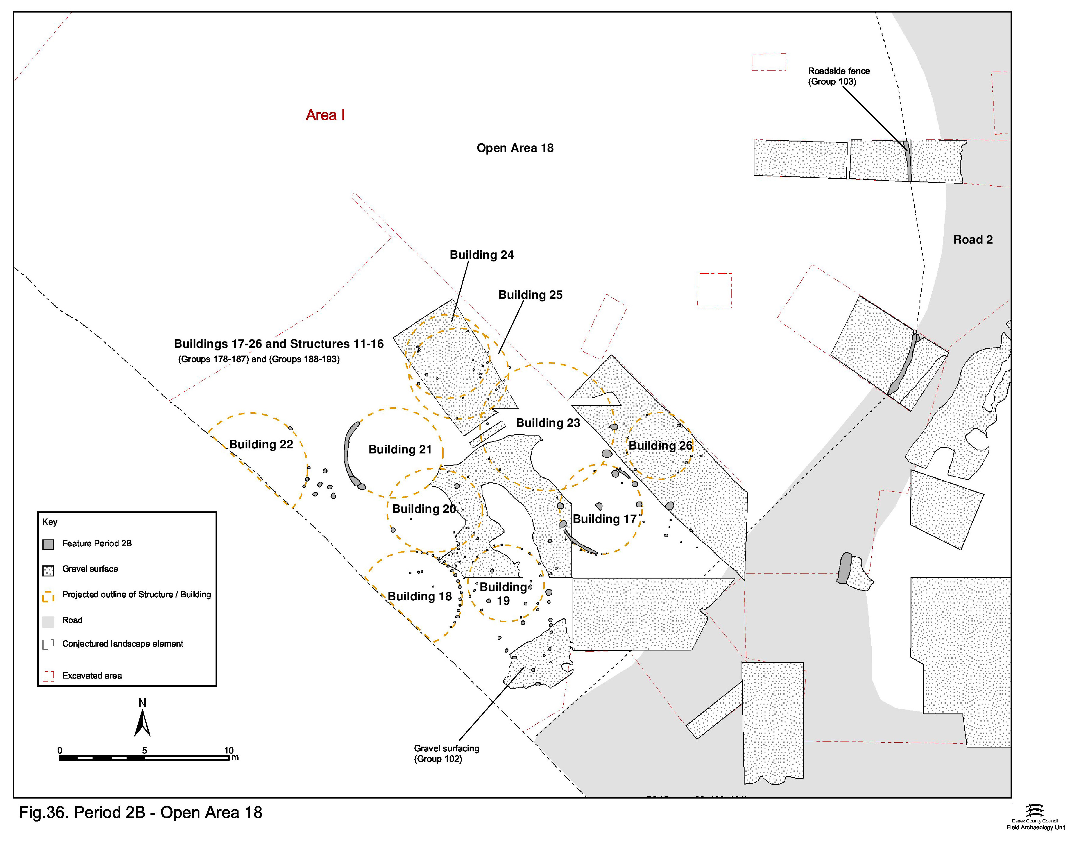
Buildings 17 and 22 have been construed to have each had a central post-hole, but other than these, none contain internal features such as hearths. Human infant remains are present in the possible doorway post-hole 13167 of Building 23, presumably constituting a special foundation deposit.
Other post-hole structures and minor fence-lines (Structures 11-16, Groups 188-193) lie among the buildings, perhaps the most notable being Structure 11 (Group 188). This is a triangular arrangement of five post-holes interpreted as a possible rack construction.
Despite the absence of diagnostic rubbish disposal within this enclosure, the occupation represented by these buildings suggests domestic occupation in an enclosed compound. Any associated pits are presumably located away from the buildings, perhaps outside the compound. The presence of a fence along the road frontages (Group 103, see above) perhaps emphasises the private nature of activity in this enclosure - in contrast to that of OA17 on the other side of the road.
Like OA17, Open Area 19 (Figure 37), though a more regular shape in plan, is also bounded by newly created roads - in this case Roads 1, 4 and 5. Clearance and infilling of earlier Period 2A landscape features, such as Waterhole 6734, is carried out in advance with significant levelling evidently required, as evidenced by a thick deposit of brickearth being laid as make-up and the overall ground level raised by an average of almost 0.25m (Group 195). As with the other enclosures of the central zone, a gravel surface (Groups 118, 119, 120) is subsequently laid across its interior. At least part of its limits is demarcated by a ditch (Group 134) that runs along the north side of Road 4. While the Period 2B internal organisation and use of OA19 is poorly understood, some distinctions between its western and eastern parts can be made.
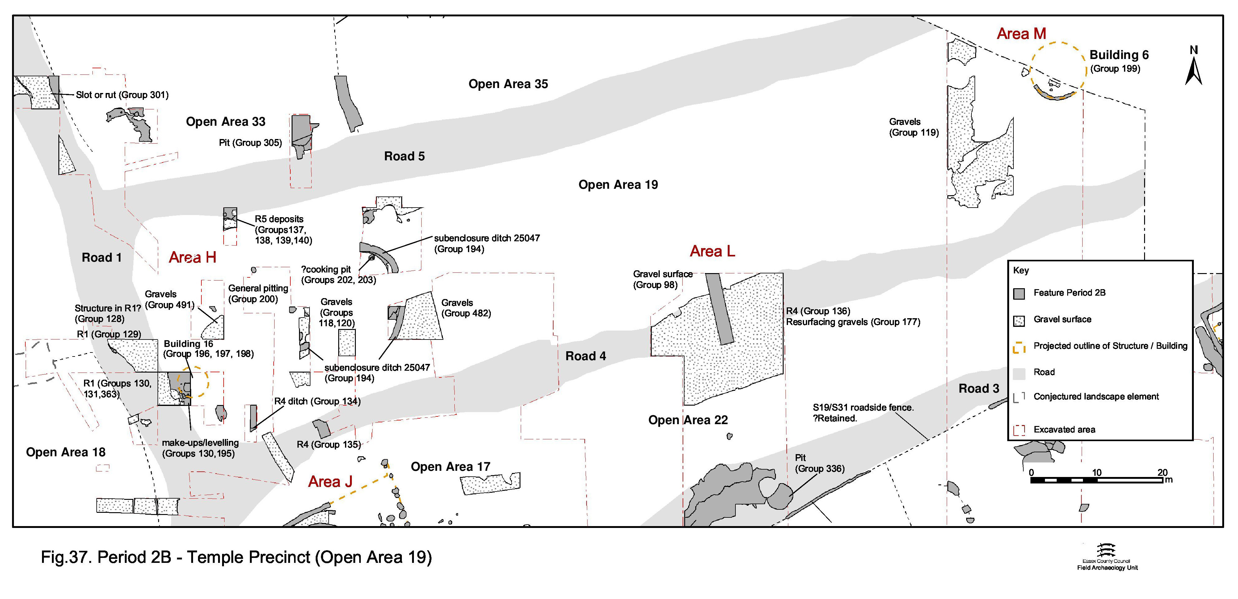
At the west end of the enclosure, closest to Road 1, the gravel-surfaced interior is primarily occupied by an oval enclosure demarcated by ditch 25047 (Group 194). Perhaps open along the Road 1 frontage, the oval enclosure contains only pits of Period 2B date. Indeed, the majority of all the OA19 pits are within the oval enclosure. These are thinly scattered, in contrast to the clustering common in most parts of the site, and contain relatively few finds. Consequently, there is little to indicate the function of most of them and dating evidence is sparse. Shallow pit 6478 (Group 202), of Late Iron Age date, is noteworthy for having a possible pebble lining and 11 stake-holes (Group 203) cutting its base. Four of the larger stake-holes could be construed to form a square arrangement in the middle of the feature, though the smaller stake-holes show little sign of patterning around them. This may constitute the remains of a cooking structure of some form, but there is a conspicuous absence of clear evidence of in situ burning. This feature is, however, poorly stratified and it remains possible that it pre-dates the creation of Open Area 19.
Patchy gravel resurfacing that seals some of the pits may denote deliberate restitution of the enclosure surface.
Building 16 lay in the south-west corner, close to the junction of Roads 1 and 4 and outside sub-enclosure 1. The partial slot and post-hole remains (Groups 196, 197) represent part of the wall line of a c. 5m diameter roundhouse, within which a gravel patch (Group 198) may constitute an internal floor fragment.
The east end of OA19 appears to be largely devoid of occupation features, perhaps being an open space much like that to the east of the temple complex in OA17.
The exception is Building 6 (Group 199), located on the southern edge, alongside Road 5. It was represented by a curving gully, which formed approximately one quarter of an 8-10m diameter circle. No pits or other occupation features can be associated with its use.
The system of enclosure ditches (Enclosure System 6, ES6). laid out over the Southern Zone of the settlement, that is the part of the lower terrace south of Road 3, in Period 2B incorporate elements of the preceding Period 2A layout and, as such, constitute modification rather than wholesale replacement. In many ways, this part of the lower terrace appears the least affected by the settlement remodelling episode. This modified enclosure system defines the character of the Southern Zone until the beginning of Period 4 (late 2nd to early 3rd centuries AD) and therefore survives for c. 150 years. Parallel ditch lines 25075, 25082, 25089 and 25178 (Groups 143, 144, 145, 146) demarcate three rectilinear enclosures to the south of Road 3 in the eastern part of the excavation area.
Further west, two other, more closely spaced, ditches were not investigated, but were recorded on the pre-excavation plan made of the site. Both are parallel to the other enclosure ditches to their west and either, or both, may have formed part of the enclosure system as laid out in Period 2B. Because of their potential significance, these un-numbered features are included in this consideration of the Southern Zone layout (Group 149). Five enclosures can be defined - Open Areas 24-28 (Figure 31) - and are collectively referred to as 'the southern enclosure system' throughout this text. All five component enclosures, varying in width between c. 50m and 60m, front onto the south side of Road 3 and are presumed to extend as far as the terrace edge c. 150-170m to the south. Fence-line Structures 19 (Group 117) and 31 (Groups 115, 116) and roadside continuations of the ditches (25091 Group 145) separate the southern enclosures from Road 3. The enclosure system can be discerned to extend eastward, with some elements evident in the plan of the un-investigated remains of southern part of Development Area A3.
The activity within each of these enclosures is discussed below, from west to east, outwards from the perceived settlement centre. It should be noted that it is not known whether some of the Period 2A features in the southern zone enclosures (e.g. the roundhouses) survive into Period 2B or are replaced as part of the settlement remodelling episode. Given that this southern part of the lower terrace is seemingly less affected by remodelling, survival is entirely possible. However, it is perceived that occupation within the enclosures now looks north onto Road 3, instead of south and that there is a shift of buildings toward the road frontage.
Open Area 28 (Figure 38) is the westernmost of the southern enclosures fronting onto Road 3. It is probable that it is a wide, shallow land unit, at least 70m along the line of the roads and extending c. 50m south to its probable boundary on the natural gravel terrace edge. Activity within OA28 is less well dated than in those southern zone enclosures further east. However, two phases of activity can be defined on stratigraphic criteria. Building 2 clearly pre-dates Building 1 and some of the pits (Group 275) do seem to be generally earlier than others (Group 276).
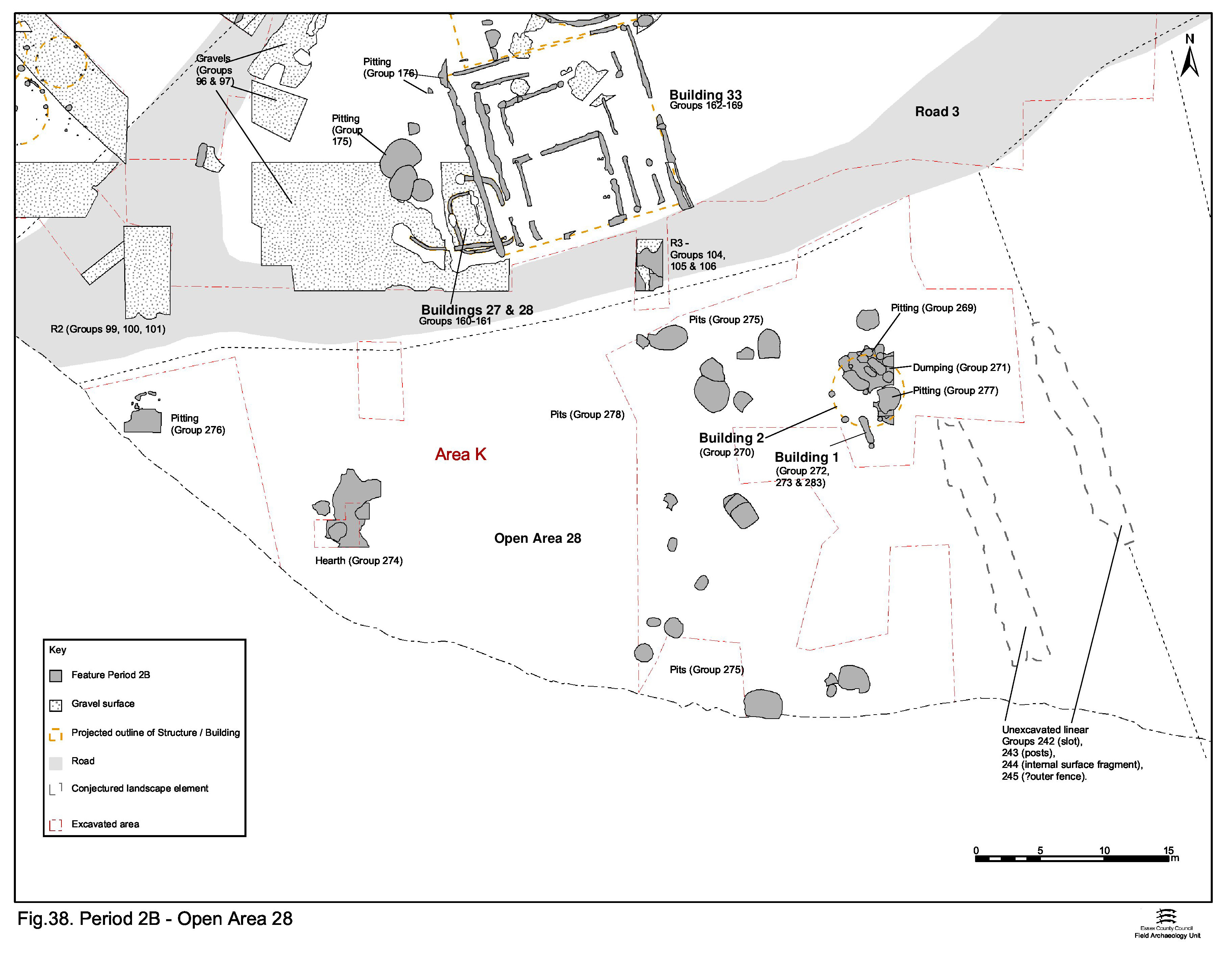
The earlier Period 2B occupation includes Building 2 (Group 270), a roundhouse c. 5.6m in diameter (Figure 39), which occupies a position toward the north-east corner of OA28, close to Road 3. Some pits (Group 269) are pre-dated either by Building 2 or by the dumping (Group 271, below) that seals the building. Other pits (Group 275) lie to the south and west of Building 2 and may be broadly contemporary with it. They are filled no later than the mid-1st century AD. Items such as loomweights, spindlewhorls, and quern fragments all indicate a predominantly domestic function for this enclosure. However, pit 14007 (Group 269) contains metalworking mould fragments, and copper-alloy cast waste (SF8346) is present in pit 4776 (Group 276), which may indicate metalworking activity is being carried out within the enclosure at this time. Hearth 14104 (Group 274), set to the west of Building 2, is poorly stratified and undated but is thought to be associated, although the use of the hearth for metalworking cannot be archaeologically demonstrated. It is also possible that the hearth is earlier and related to the metalworking debris found previously in Open Area 4 in Period 2A.
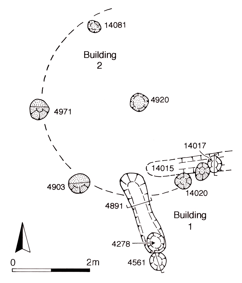
Later activity within OA28 is defined by a patchy dumping sequence (Group 271) sealing Building 2, which also includes metalworking debris. These dumps may perhaps be truncated by the extensive topsoil stripping that precedes the creation of the road network and associated gravel surfaces. It is possible therefore that the metalworking evidence from OA28 derives from features that ante-date the road system. However, there is no indication that the remodelling groundworks extend across the Southern Zone. The dumps are cut by slot-built Building 1 (Group 272, 273), only a corner of which survives (Figure 39). Burnt daub fragments within its foundation slots may derive from its structural fabric.
Later Period 2B activity in OA28 is otherwise dominated by pitting. A number of the pits (Group 276) are filled during the first half of the 1st century AD and at least two (4193, 4496) receive material mainly during the mid-1st century AD; fragments of tile were also present. Some are evidently later additions to the large Period 2A inter-cutting complex (Group 62), which suggests that such concentrations of pitting develop over prolonged periods of time. Pits 4258 and 4463 contain notable quantities of metal objects and waste, and 4786 also includes metalworking debris, including mould fragments.
Other pits, with less datable assemblages (Group 278), can only be broadly dated to the Late Iron Age. Late Iron Age pit 4984 (Group 277) post-dates Building 1 and serves to demonstrate that this Period 2B structure is seemingly short-lived.
Open Area 27 (Figure 40) lies to the east of Open Area 28 with which it shares its western boundary. The eastern side of the enclosure is also defined by a ditch alignment (Group 146). Part of its northern boundary is formed by a fence-line alongside Road 3 (Structure 19 Group 117). Three sub-phases of activity within the enclosure are apparent on the basis of inter-cut relationships, though this may amount to no more than a general continuum of occupation.

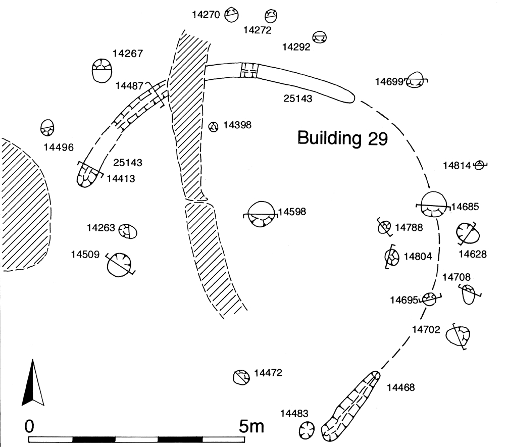
The earliest phase includes circular slot- and post-built Building 29 (Groups 242, 243). Approximately c. 8-8.5m in diameter, a line of similar post-holes (Group 245) follows its curve immediately to the north, perhaps denoting a more elaborate structure or alternatively an enclosing or sheltering fence (Figure 41).
East of Building 29, a dense inter-cutting cluster of pits (Groups 246, 247, 752) lies near the enclosure boundary. Although some receive fills perhaps as late as the middle third of the 1st century AD, finds are sparse considering the relatively large size of the pits. Further pits (Groups 248, 258), whose infilling occurred in the first half of the 1st century AD, were spread widely over the western part of OA27. The majority of these early Period 2B pits contained typical assemblages of pottery together with modest quantities of briquetage, animal bone and occasional items of metalwork.
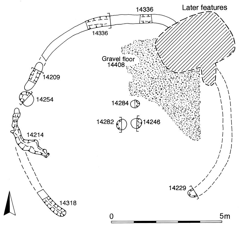
In the second phase, a new circular building, Building 36 (Groups 250, 251), is constructed just south of Building 29 (Figure 42). Its foundation slots indicate a diameter of c. 9.4-9.6m. Post-holes 14246 or 14282 could mark the location of a central roof support within this building. Traces of a possible gravel floor (Group 252) lies on the east side of the roundhouse interior. A mid-1st century date for the building is derived from small quantities of pottery from the remains of the building itself and from the pits (Group 258) that it post-dates.
Structure 20, defined by a substantial gently curving gully (Groups 253, 254), lies immediately north of Building 36. While integral post-holes indicate its structural function, the gully most likely marks the position of a length of screening fence around hearth 14500 (Group 255). Structure 20 post-dates Building 29 and may be contemporary with Building 36. Later Period 2B pit 14382 (Group 260), truncating the south side of the hearth, contains mould fragments, cast waste (SF8369, SF6228) and slag derived from metalworking. Finds from this pit also included cosmetic tools (SF5544). As this pit post-dated Structure 20, if it does reflect the use of the hearth, then the screen appears to have fallen out of use before the hearth itself. While the fills of Structure 20 contained pottery that tentatively dates its filling to the Late Iron Age, the fill of the hearth included pottery consistent with a mid-1st century date.
At the north end of the enclosure, a slighter curving slot (Groups 265, 266) marks the presence of circular Structure 21, of c. 13m diameter and located immediately south of Road 3. It is likely to denote another curving screening fence, perhaps sheltering two small pits lined with orange clay (Group 267) that may in fact be hearth settings.
In the final sub-phase of Period 2B activity within OA27, Building 36 may remain in use, but the arrangement of ancillary structures to its north is altered considerably. Structure 20 is removed and a rectilinear enclosure, Structure 22 (Group 256), located to the north-west of Building 36 may have formed one side of a fenced pen c. 10.5m square. Pit/post-hole 14586 (Group 257) may constitute a structural element (or some sort of marker) on its southern, open, side. The western side of Structure 22 cuts infilled enclosure boundary ditch 25075. It has been suggested previously that this ditch is more likely to be a relict Period 2A feature than part of the Period 2B enclosure system, so Structure 22 could in fact indicate the perpetuation of the boundary.
A concentration of pitting (Group 263), dated to the first half of the 1st century AD, occurs within the area enclosed by Structure 22, but it is unclear how many of these features are directly contemporary with its functioning. One pit (Group 262), however, does appear to be centrally positioned within it. Others (Group 264) lie outside Structure 22, toward Building 36. Two further pits (Group 268) lie in the northern part of Open Area 27; of these one definitely post-dates Structure 21.
Elsewhere, pit 14574 (Group 259), which post-dates the Structure 20 hearth, is of probable mid-1st century date and includes a possible Nauheim brooch fragment within its fill. On the northern margin of OA27, a pit (Group 336) intrudes onto the line of Road 3. With a diameter of 4.0m, this large pit suggests that the road, or at least that part of it to the east of Open Area 27, is already falling out of formal use.
Open Area 26 (Figure 43), east of OA27, is well defined on three sides. While its eastern and western boundaries are marked by ditches (Groups 145, 146), fence-line Structure 31 (Groups 115, 116) denotes the northern boundary alongside Road 3. The enclosure is c. 54m wide along the Road 3 frontage, but this broadens to c. 64m at the southern limit of excavation. The enclosure probably extends south as far as the terrace edge, a distance of c. 70m. The position of any entrance into the enclosure from Road 3 is not defined. The chronology and nature of its occupation is similar to that of the other southern zone enclosures previously described. Two sub-phases are identified.
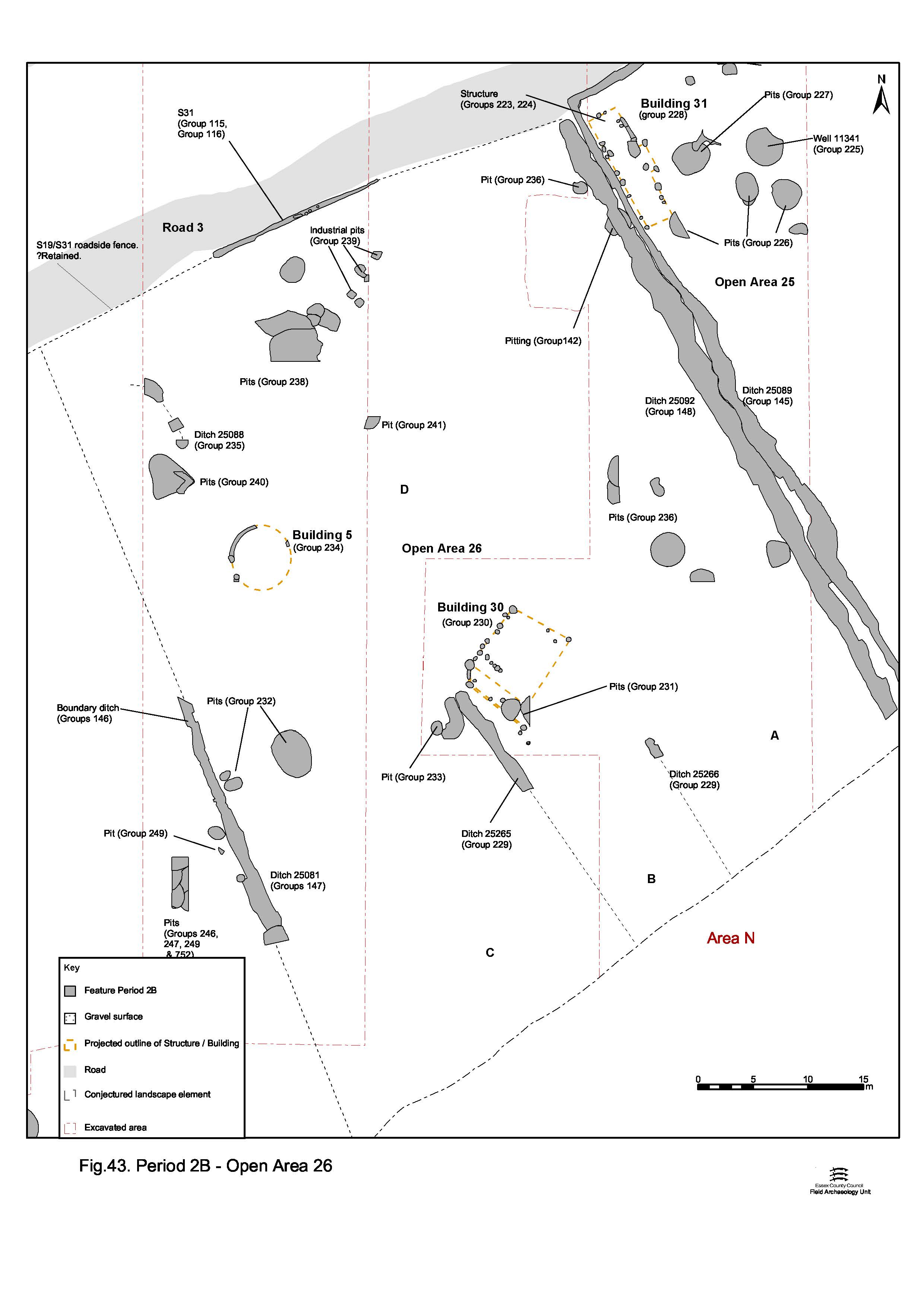
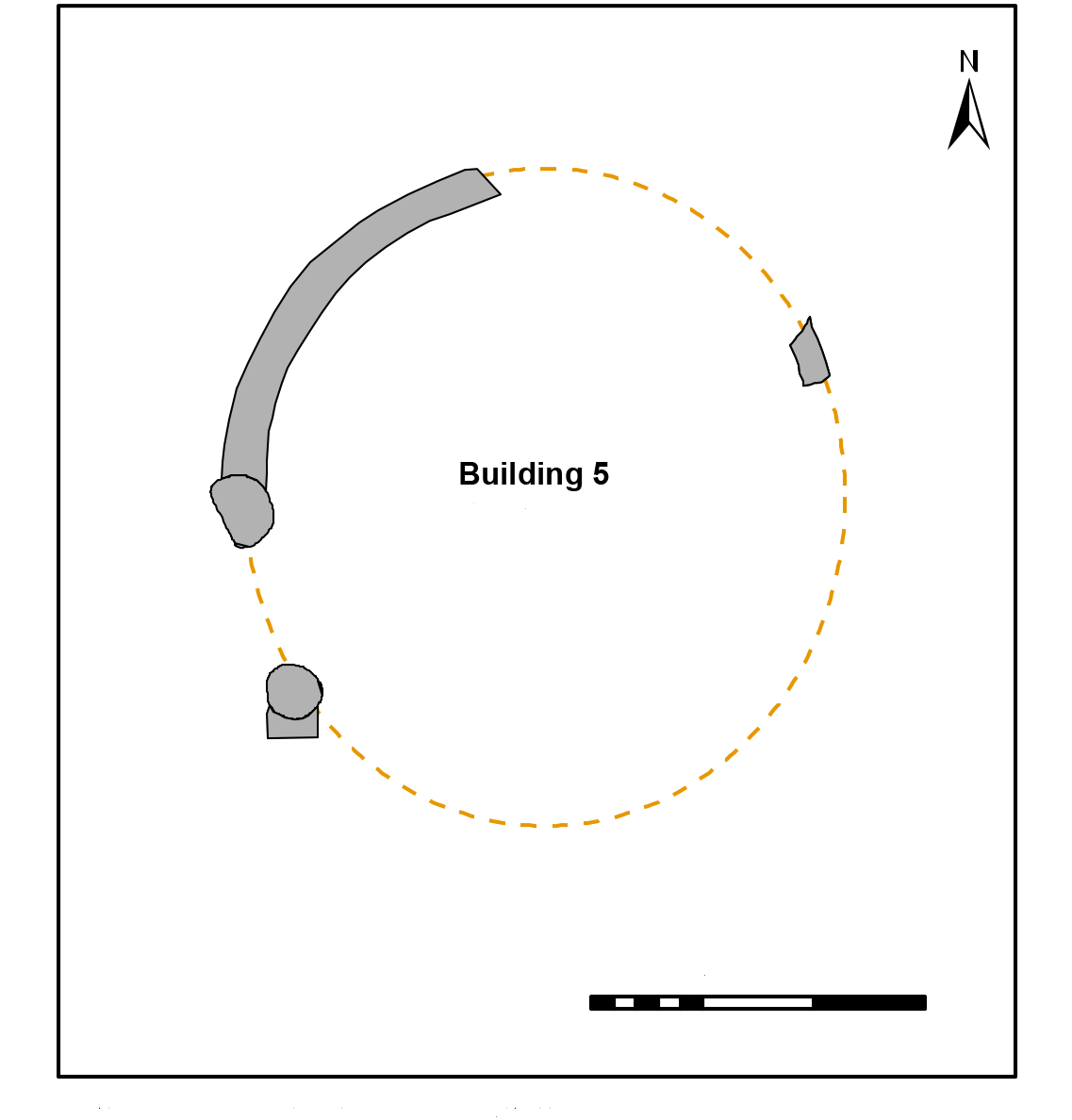
In its earlier use, the northern part of OA26 is not partitioned, but includes at least two buildings. The northernmost of these, circular Building 5 (Group 234), is of almost 6m diameter with a doorway tentatively identified on its western side (Figure 44). The pottery from Building 5 indicates a date towards the mid-1st century AD, most probably for its disuse. This could be a Period 2A structure that survives into Period 2B. A ditch (Group 235), of probable early to mid-1st century AD date, lay to the north of Building 5. It may represent a drainage ditch, or a relatively minor subdivision within the frontage of the plot.
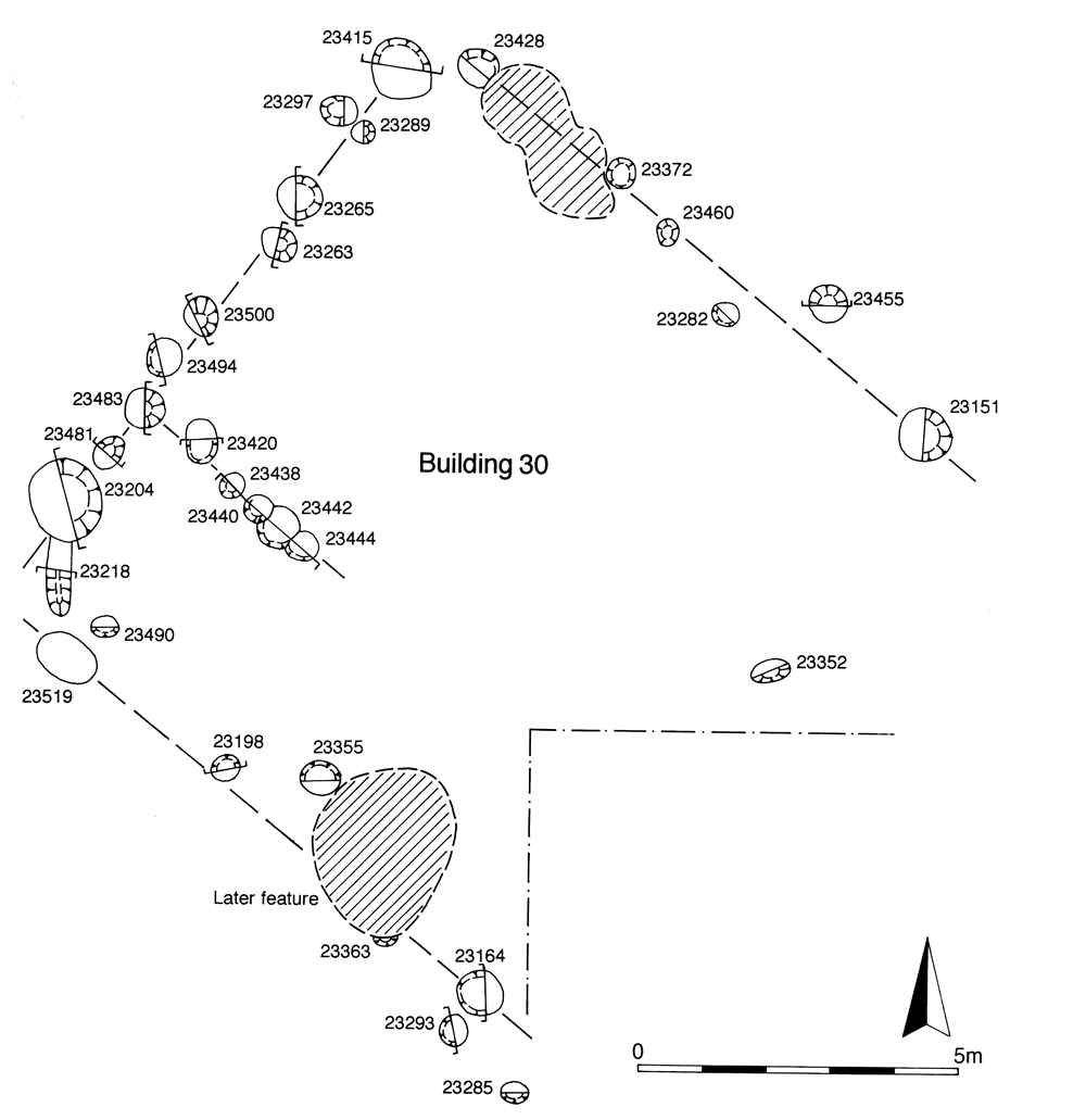
Further south, Building 30 is a rectilinear building tentatively extracted from a mass of excavated post-holes (Group 230), of which only the north-west wall of the building is reliably defined (Figure 45). A building measuring 8m by 7.5m may be suggested. The small quantities of pottery recovered provide an early to mid-1st century date, but the nature of this assemblage is unclear; and it is uncertain whether it derived from the construction or destruction of the building (or a mixture of both). The alignment and shape of this building are atypical - it is orientated skew to the alignment of all contemporary linear features in the vicinity, and seems to be almost square in plan, which contrasts with the round or rectilinear/strip buildings seen elsewhere across the settlement at this period. It should be noted that the number of undated post-holes in this part of the site means that alternative interpretations of the building's layout are possible.
South of Building 30, the enclosure interior is subdivided by ditches (Group 229) into three sub-enclosures (labelled A, B, C from E-W). The narrower, central sub-enclosure (B) may be directly associated with Building 30, which sits at its northern end. Pitting (Groups 232, 233) is only present in the westernmost sub-enclosure (C); these span the earlier to mid-1st century AD, the latest including small quantities of ceramic building materials in its upper fills.
Across the undivided northern half of the enclosure pits accumulate material into the middle of the 1st century AD, their upper fills containing some Roman ceramics (Groups 236, 238). A distinct group of smaller square pits (Group 239) cluster close to the Road 3 frontage. All contain metalworking debris or metal objects, both iron and copper alloys, and at least one mould fragment is present. These are very similar to pits (Group 207) in adjacent OA25 (see below).
Later Period 2B occupation includes the modification or re-establishment of the eastern enclosure boundary with the imposition of Ditch 25092 (Group 148), which is similar in size and parallel to ditch 25089 (Group 145, above), running immediately alongside it. It is unclear why this boundary should be reinforced in this manner.
Two Period 2B pits (Group 231) lie within the probable footprint of Building 30, the earlier of the two (pit 23365) dating to the mid-1st century AD. It might be considered unlikely that the building is built over a large pit of this date. It is probable, therefore, that the pits post-date the building, thus signalling its demise before the end of the period.
Located in the north-west of OA26, substantial triangular-shaped pit 15641 (Group 240) may be cut as early as the early to mid-1st century AD, but continues to receive fills into the later part of the century. Possibly lined with gravel and pebbles set in clay, its lower fills are ash-rich and contain a number of ironwork items and burnt pottery. This distinctive pit may have been marked by a post-hole and it is tempting to draw some parallels with the earlier pyre debris pit 15417 (Group 33, Period 2A) nearby.
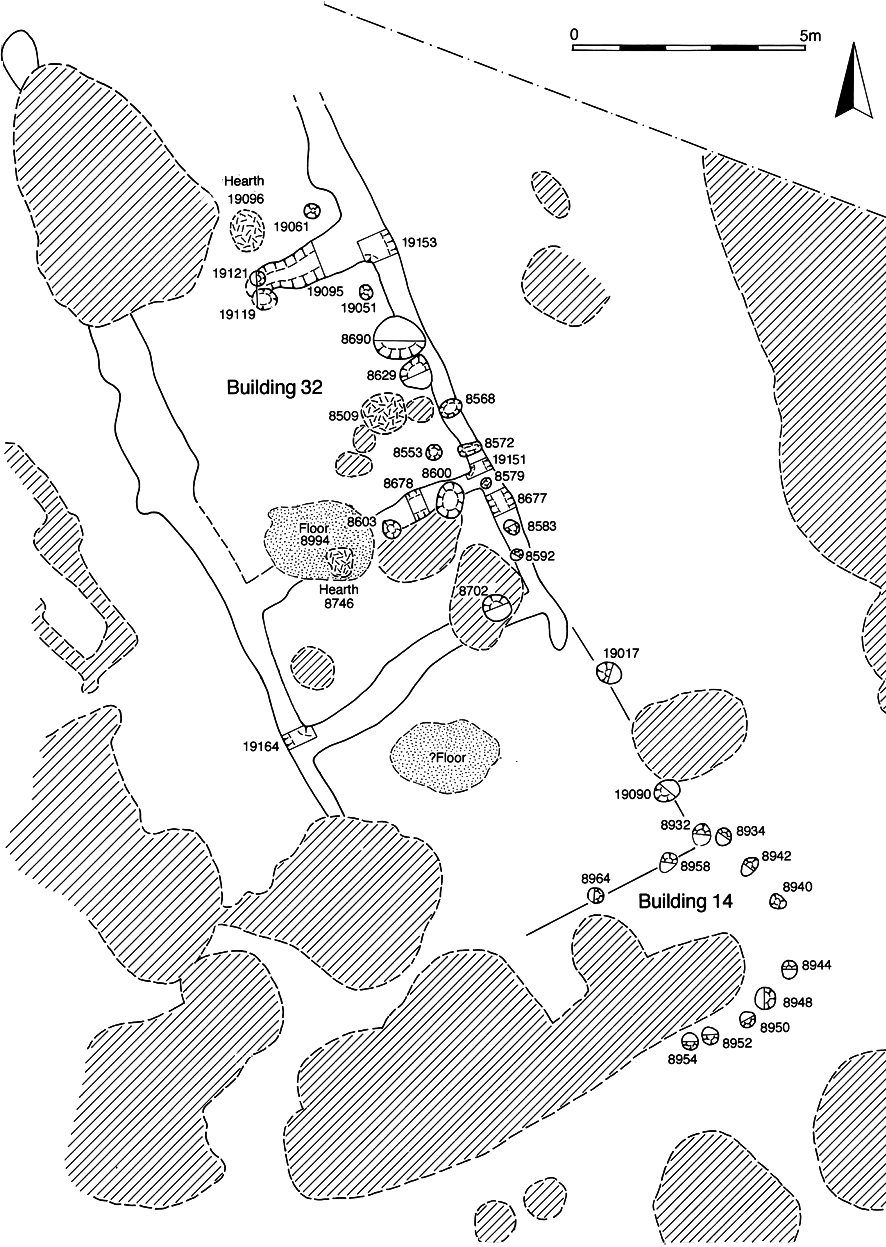
Open Area 25 (Figure 46) lies to the east of OA26. It is the best defined of the southern enclosures with the majority of its western, northern and eastern boundaries marked by ditches (Group 144 and 145). The enclosure is c. 45m wide and probably extends c. 70m south of Road 3. A narrow entrance, marked by a gap between ditches 25090 and 25091, provided access into the enclosure from Road 3.

Two buildings occupy the frontage corners of the enclosure, end-on to Road 3 and aligned on the plot boundaries. In the north-east lies Building 32 (Figure 20), a rectilinear structure that survived as an arrangement of shallow foundation slots and post-holes (Groups 210, 211). Some 22m x 7m in area, the building comprises three rooms within which clay floors and hearths (Groups 212, 213) occur. Later features respect the Building 32 footprint and there is a strong presumption that a building continues to occupy this plot into Period 3. A concentration of pits (Groups 216, 217) is located to the south and east of Building 32 and are probably associated with its use. They date to the first half of the 1st century AD.
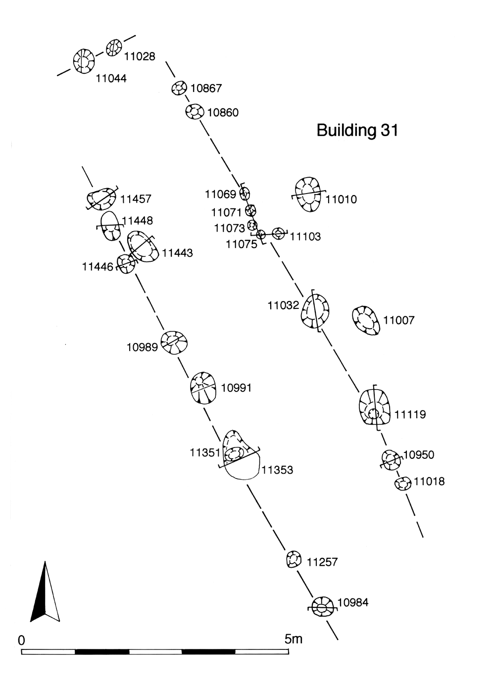
A second, smaller and less substantial, strip building, Building 31 (Group 223, 224), occupies the north-western corner of the enclosure. The southern end of the building is not certainly identified, but it may be c. 11.50m long (Figure 47). No evidence for internal hearths or partitions within the building is present, though the position of a doorway is tentatively identified midway along its east side. Given its very restricted width, Building 31 would seem to be an ancillary structure, perhaps a livestock pen/stable. The building passes out of use by the end of the 1st century AD, by which time further pits are dug on its site.
Well 11341 (Group 225) is located between the buildings. A construction date in the early 1st century AD is likely but it is less clear how long the well remains in use. It is probable that it survives until being replaced by Well 8989 (Group 662 Period 3) in the mid-2nd century AD. However, its slump hollow continues to accumulate material into the mid 3rd century AD.
The pits in the vicinity of Building 31 and Well 11341 are large and generally circular (Group 226). They overlie a cluster of Period 2A pits and contain the same kinds of finds assemblages; indeed, some may constitute continuity of the patterns of Period 2A activity and rubbish disposal into the mid-1st century AD (though there is obviously a risk that some material is being redeposited as the later pits cut through the earlier). Four small, distinctive pits (Group 207), all roughly square, of broadly similar size and with related fills, lie between Well 11341 and Road 3 in the north-west corner of the enclosure. They contain small quantities of slag, hammerscale, copper alloy and iron cast waste. Crucible fragments are also present. One of the pits (10873) lies further north, outside the southern enclosure system and on the line of Road 3. While it is possible that it is an earlier feature, features do encroach elsewhere upon the road. These pits are to some extent reminiscent of the Period 2A hearths (Group 205) and may indicate continuity of metalworking practice at this location.
The southern (rear) part of OA25 is subdivided, possibly by fences or hedges, into three rectilinear sub-enclosures (labelled A, B, C from east to west) as denoted by a number of linear slots (Groups 208, 209). The pattern of subdivision reflects that seen in OA26 to the west. The dating evidence is sparse but some of these subdividing boundaries pass out of use by the mid- to late 1st century AD when they are cut by Roman pits (Period 3 Group 222). Only a few pits of Period 2B date are scattered among these sub-enclosures (Groups 218, 219, 220, 221), perhaps reflecting their use as cultivated gardens or animal pens.
Open Area 24, the easternmost of the investigated southern enclosures, is only partially impinged upon by Excavation Area P. Its western side is defined by the ditch 25178 (Group 144) but its other boundaries lie beyond the excavated area, along with the majority of its interior. Only a single pit, 8907 (Group 204), of probable Period 2B date, occupies the enclosure, marginally cutting the edge of boundary ditch 25178. Its eastern boundary cannot be readily discerned on the pre-excavation plan of Development Area A3, but a rectilinear building is apparent, similar to Building 32 in OA25, positioned end-on to Road/track 3. It is likely that this structure therefore occupies a further part of OA24 in Period 2B, and perhaps later.
As is the case with the Southern Zone, the onset of Period 2B is represented by a major change in the layout of the enclosure boundaries across the northern side of the lower terrace (Figure 31). However, separated by the Central Zone, the layout and subsequent development of this system is markedly different, being less regular and split into two by Road 1. In order to describe the various elements adequately, two distinct enclosure systems are defined (ES9 and ES11) that comprise the Northern Zone.
The Period 2B landscape divisions that extend across the north-western part of the lower terrace, west of Road 1 and north of OA18, define four enclosures within the investigated area - Open Areas 29-32 (Figure 48) . The principal north-south boundary is formed by ditches 25019 and 25020 (Group 151), which probably represent two phases of the same basic landscape division. It bounds the eastern side of OA29 and the western side of OA31, extending south almost as far as the corner of OA18. To its east, ditches define the extents of two further enclosures. Right-angled ditch 25039 (Group 152) forms the northern and western sides of rectangular Open Area 32, seemingly deliberately laid alongside and with reference to the Road 1 alignment. A gap in the north side marks an access into Open Area 31.
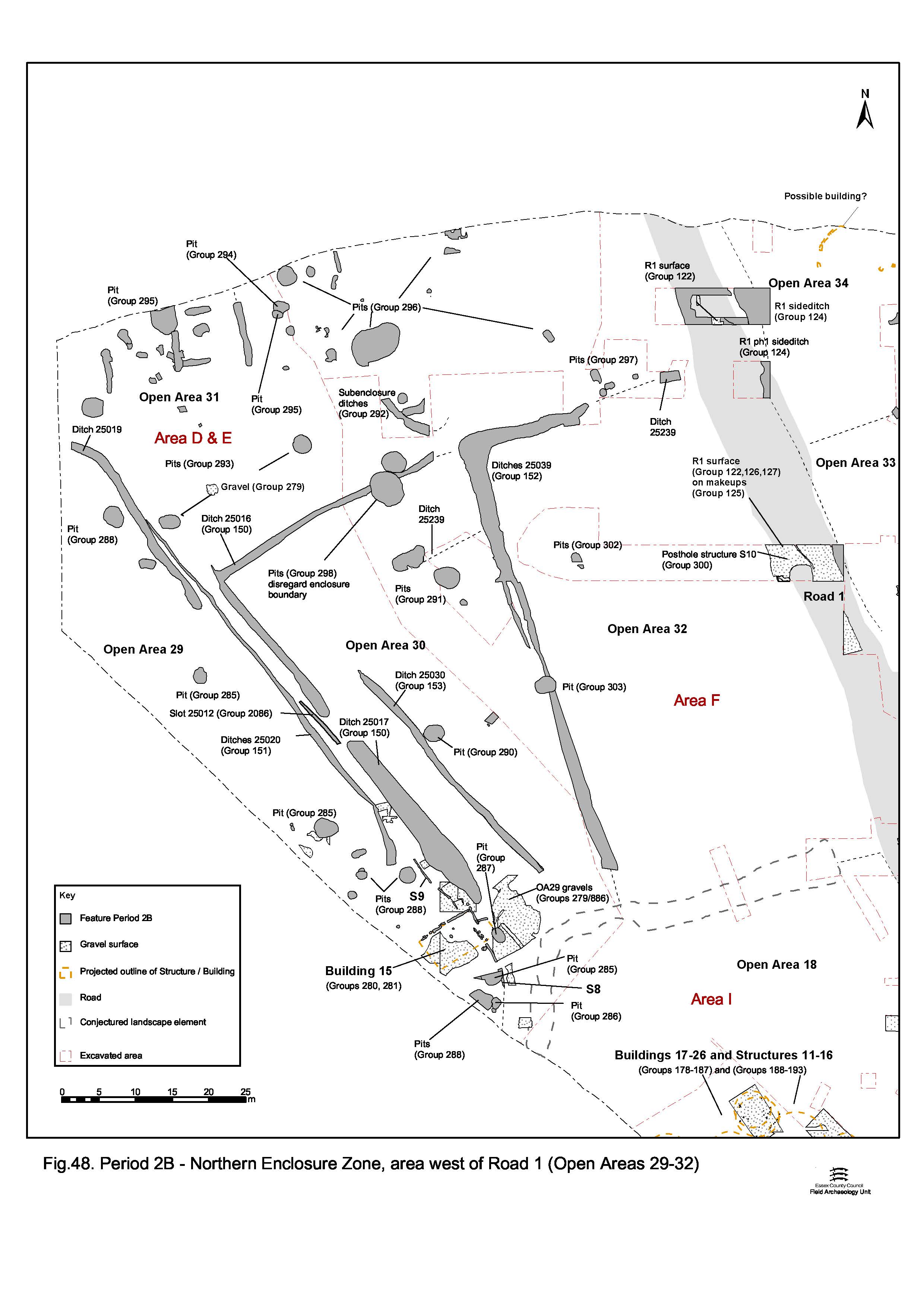
Open Area 30 is formed of the available space in between the OA29 and OA32 enclosure boundaries, which accounts for its southward tapering shape. Ditches 25016 and 25017 (Group 150) define the west and north limits of the enclosure. OA29 and OA30 are separated from one another by a c. 1.6m-wide routeway through, and connecting, the various units of the enclosure system. Indeed, a centrally positioned entranceway onto this access route is present in the west boundary of OA30. The second phase of the OA29 boundary (ditch 25019) represents a modification that involves shortening the boundary and simplification of the landscape with the effective removal of the routeway, or else its retention and incorporation into OA29.
The southern limit of OAs 30 and 32 is not certain, but it is probable that the substantial Period 3 ditch 25027 (Group 838) that later defines the northern edge of OA18 perpetuates an earlier landscape division relevant here. There is some stratigraphic evidence to suggest that ditch 25039 may post-date 25016, and consequently Open Area 32 may constitute a subdivision of what was originally a much larger OA30. However, the dating of any such subdivision cannot be archaeologically defined. It is reasonable to conclude that ES9 should be seen as contemporary with or post-dating the construction of Road 1. This is reinforced by the fact that Road 1 demonstrably post-dates some of the Period 2A enclosure ditches (ES2 ditches 25241, 25251; OA2 north boundary modifications 25121/25250, 25224).
Open Area 31 is that part of the lower terrace north of and defined by the boundary ditches of OAs 29, 30 and 32 and by Road 1, and apparently lacks boundaries of its own. The westward curve of the OA29 boundary may indicate that, as previously suggested for Period 2A OA12, it constitutes a wider band of marginal open ground alongside the watercourse.
Cumulatively, Enclosure System 9 presents the evidence for a coherent field system to the north of Open Area 18. The presence of an integral routeway clearly indicates a need for access through these enclosures (OA29, OA30) from the settlement alongside Road 2 to the enclosures to the north (e.g. OA31) and presumably to the hinterland beyond. As pertinent is the incidence of regular access points between these enclosures. The inter-connectedness of these fields, could hint at a pastoral function with management and movement of livestock between enclosures close to the settlement and into wider-ranging rough pasture beyond.
A further noteworthy aspect of ES9 is its apparent radial placement, emanating from the north-west corner of OA18. This nodal point seems to give access into the various open areas from the settlement. As such, it is perhaps not coincidental that a building is also located at this relatively important point in the landscape (Building 15).
Only the eastern edge of the OA29 interior is exposed within Excavation Area D (Figure 48). However, its south-eastern corner seems to have been something of a focal point of activity within this enclosure. This area appears to be levelled or prepared with the deposition of an extensive gravel surface (Groups 279, 886) set on a brickearth make-up layer, which extends through the gap between enclosure ditch 25017 and the corner of OA18 and a short distance into the interior of adjacent OA30.
Positioned adjacent to this entranceway, rectangular Building 15 (Groups 280, 281) occupies the gravel surface. It is over 8m long and 5m wide, with a possible small square addition at its northernmost corner (Figure 49). Although its function is uncertain, the building is likely to remain in use into the late 1st century AD (Period 3).
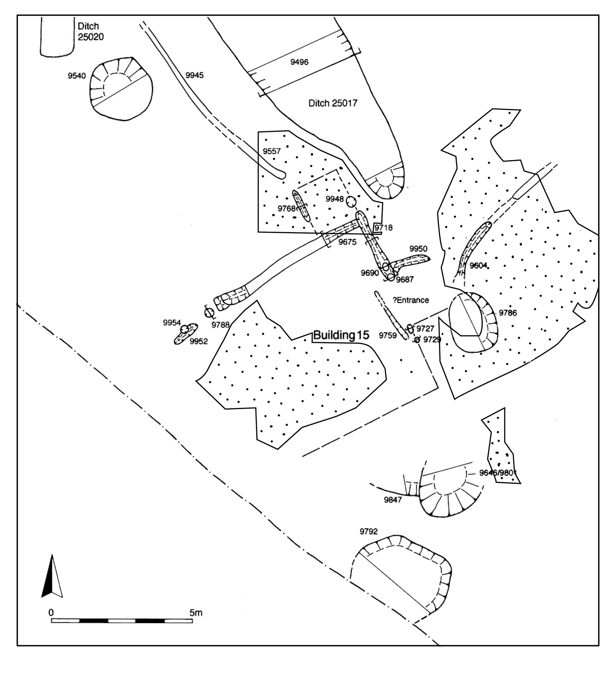
Fence-line structures 7, 8 and 9 (Groups 282, 283, 284), represented by lengths of straight or slightly curving slots, are located in the immediate vicinity of Building 15 and are presumed to be associated. Building 15 and its fences would appear to be deliberately located at the point of access between the enclosures and may have something of a controlling function.
Late Iron Age pits (Groups 285-288), generally large and circular in plan, occur within OA29 and display a tendency to cluster in the vicinity of Building 15. Some of these may well be associated with the use of the building.
The interior of OA30 is occupied by relatively sparse remains of activity (Figure 48). Various gully/ditch alignments indicate its subdivision - particularly associated with the various points of entry into the enclosure - that suggests the management of livestock movement.
Internal gully/ditch 25030 and minor slot 25012, located just outside the western entrance (Groups 153, 2086), may have a channelling function, while in the north-east corner, gully 25239 (Group 289) may constitute a fenced holding pen at another postulated point of access into OA30. OA30's speculated use as a livestock enclosure may account for the paucity of pits across its interior. Those that are present (Groups 290, 291, 298) are mostly large and circular. All are positioned either alongside or on the enclosure boundaries or those of its internal subdivisions, leaving the majority of the interior clear.
The interior of OA31 (Figure 48) contains a greater diversity and quantity of occupying features than those of the enclosures to its south (OAs 30 and 32). This may hint at a multi-functional aspect to this less well-defined and somewhat peripheral land entity. Part of its interior is occupied by a series of possible animal pens, denoted by minor ditches in a rectilinear arrangement (Groups 154, 155). Oddly, these conform better to the preceding Period 2A prevailing alignment than to that of the Period 2B enclosure system. However, they may instead have primarily been aligned upon the watercourse to the north.
Pits are dispersed across the exposed extent of OA31 (Groups 293, 294, 295, 296, 297), with a greater density occurring than in the Northern Zone enclosures to its south. There is considerable variation in size, shape and content of these pits. Of note are the rectangular, almost slot-like, pits (Group 297) at the east end of the enclosure, within Excavation Area F; these contain similar artefact assemblages as the other Period 2B pits.
Despite its whole extent being exposed within Development Area A1, OA32 is the least investigated of the Northern Zone enclosures west of Road 1 (Figure 48). Homogeneous silts covered much of its interior. Consequently, relatively little of the nature of its occupation during Period 2B is understood.
Identified Period 2B activity is restricted to a small quantity of pits only (Groups 299, 302, 303), all of which are positioned close to or on the enclosure boundaries.
The part of the Northern Zone enclosure system east of Road 1 is significantly different from that to the west (Figure 50). Admittedly poorly understood, mainly because of the seeming lack of landscape change and development through time, its sub-division into different enclosures is somewhat tentative and largely based upon a presumed perpetuation of earlier boundaries. It is considered likely that elements of the preceding Period 2A landscape are retained. North-south ditch 25045 (or some perpetuation of it - such as a hedge-line), which previously divided Open Areas 10 and 11, is incorporated into the new enclosure system. Supplemented by the introduction of east-west ditch 25041/25042 (Groups 156, 157), that itself in part follows the course of earlier curving ditch 25044 (Group 79, Period 2A), a new rectilinear enclosure layout is created. As exposed within Excavation Area G, these boundaries define parts of four large enclosures; Open Areas 33 to 36. The probable eastward extension of this enclosure system along the terrace is evident in Excavation Area R, as represented by two parallel ditches 12284 and 12360 (Group 334) of Late Iron Age date. ES11 is construed to comprise regular rectilinear land divisions laid out across the full north-south extent between the road and the watercourse at the foot of the upper terrace. Its alignment follows that of Roads 1 and 5. The dating evidence suggests that the ES11 ditches were infilling in the mid-late 1st century AD. It is conjectured that these enclosures to some extent mirror those of the Southern Zone. Reference to the pre-excavation plan of Area A3 certainly suggests a similar density of pits and potential structural remains fronting onto Road 5.
The Period 2B occupation of OA33 is poorly understood, much of its interior being uninvestigated (Figure 50). Only a small number of pits (Groups 304, 305, 310, 758) of mid-1st century AD date are identified at its northern and southern edges.
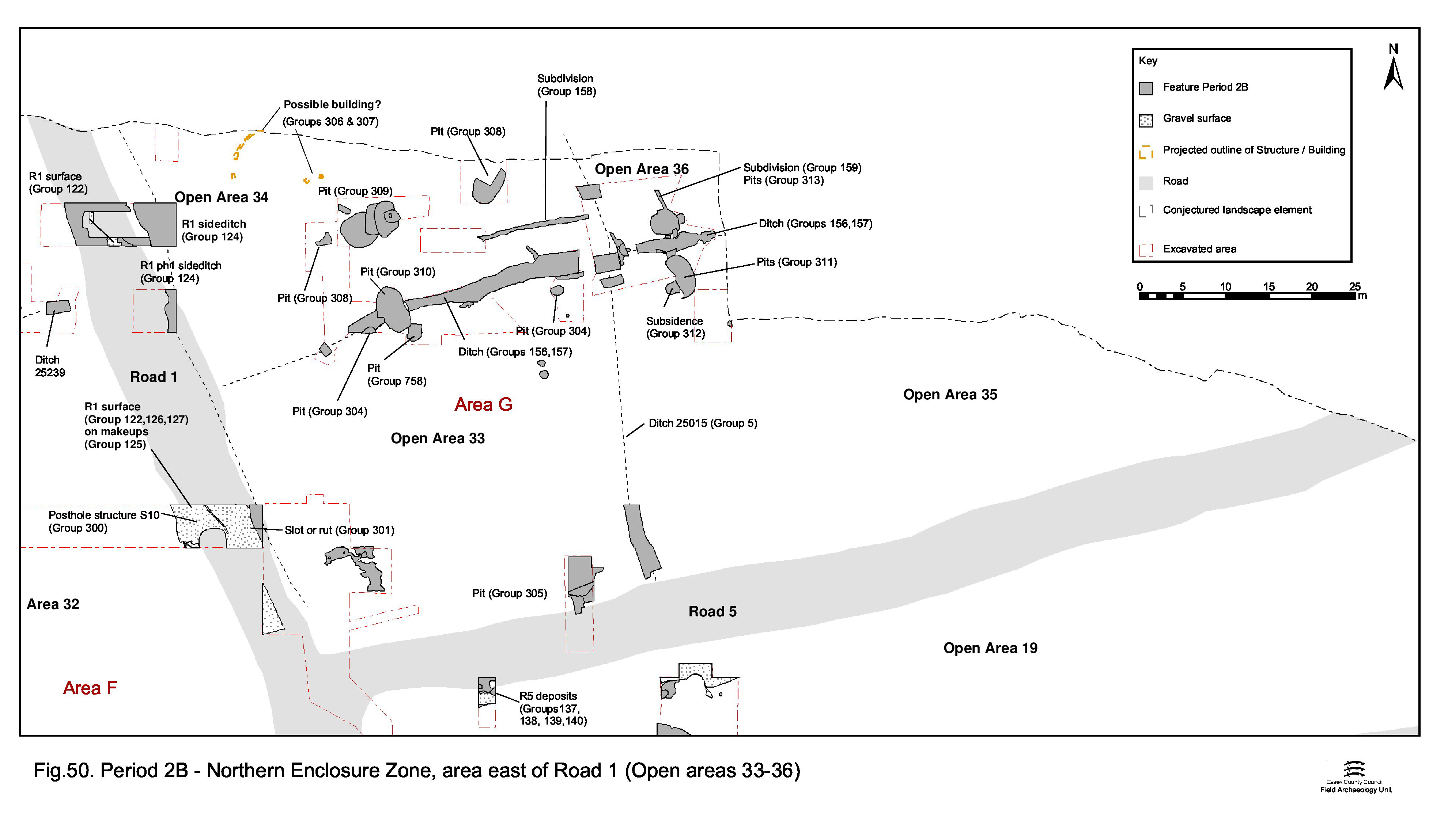
Only the southern end of OA34 was exposed within Excavation Area G, though it is speculated that this enclosure may extend as far north as the watercourse (Figure 50). East-west gully 25113 (Group 158), runs parallel to boundary ditch 25041, some 3.5-4m apart. Possibly contemporary with the enclosure boundary, it could perhaps be perceived as a replacement boundary feature, if transition period pit 7060 is interpreted as signalling the demise of ditch 25041. A possible roundhouse, represented by gully 25110 (Group 306), is located toward the Road 1 frontage. Some 11m in diameter, this is the only tangible hint of structural occupation of any of the ES11 enclosures.
A modest quantity of pits (Groups 308, 309, 313) occur to the east of this building, some (Group 309) forming an inter-cut cluster that displays chronological progression with the latest in the sequence (pit 7210) containing distinctly Romanising material.
As only the western edge of OA35 falls within the investigated area, little is known of its interior (Figure 50). Only a single pit (Group 311) of Period 2B date is discerned alongside the northern boundary. Adjacent Period 2A well 7220 continues to accumulate rubbish in its subsidence hollow into the mid-1st century and includes a Romanising component (Group 312).
Only the south-westernmost corner of OA36 falls within Excavation Area G (Figure 50). Gully 25114 (Group 159) runs parallel to the western boundary, otherwise only pits (Group 313) of Period 2B date occupy the interior. In the tentatively identified north-east corner of the enclosure (i.e. in Area R, south of the watercourse) only single oval pit 12288 (Group 335) is in evidence. Located on what was marginal, probably seasonally flooding, land close to the watercourse, this lack of Period 2B occupation is understandable.
On the upper terrace, above the Late Iron Age settlement proper, the simple land division denoted by Period 2A boundary ditch 25102 (Group 10) is replaced with a more substantial and developed system of ditches (Group 314) that sub-divides the terrace landscape into more complex land units (Figure 51). This is termed the 'Northern Hinterland' of the settlement from this point on. The alignment of the new enclosure system is, however, strongly influenced by that of 25102. Newly imposed ditch 25199 incorporates the earlier ditch at its northern end but steadily diverges as it continues southwards (possibly using the remains of Bronze Age barrow 25200 as a point of reference in the landscape). Ditches 25194 and 25188 form the southern limits of the Period 2B sub-division of the terrace. Once established, the ditch lines are re-cut on several occasions (in Period 3) and endure as a long-lasting feature of the landscape. It is probably as a consequence of this that much of the dating evidence is later than Period 2B - the only evidence for an early to mid-1st century AD date comes from ditch 25188. The very fact of this re-cutting, however, obviously implies that the origins of the enclosures are likely to be earlier than Period 3. This sub-division of the northern hinterland is presumed to be imposed in the earlier 1st century AD, which is supported by the close association of a pyre-field of this date, discussed below. Within Excavation Area W, the enclosure boundaries define five land entities - Open Areas 37-41. While the Period 2B use of these Northern Hinterland enclosures is judged to be primarily agricultural and is clearly different from that of the Southern, Central and Northern settlement zones, it is evident that at least some also had other functions, primarily funerary. This multiplicity of use is explored below.
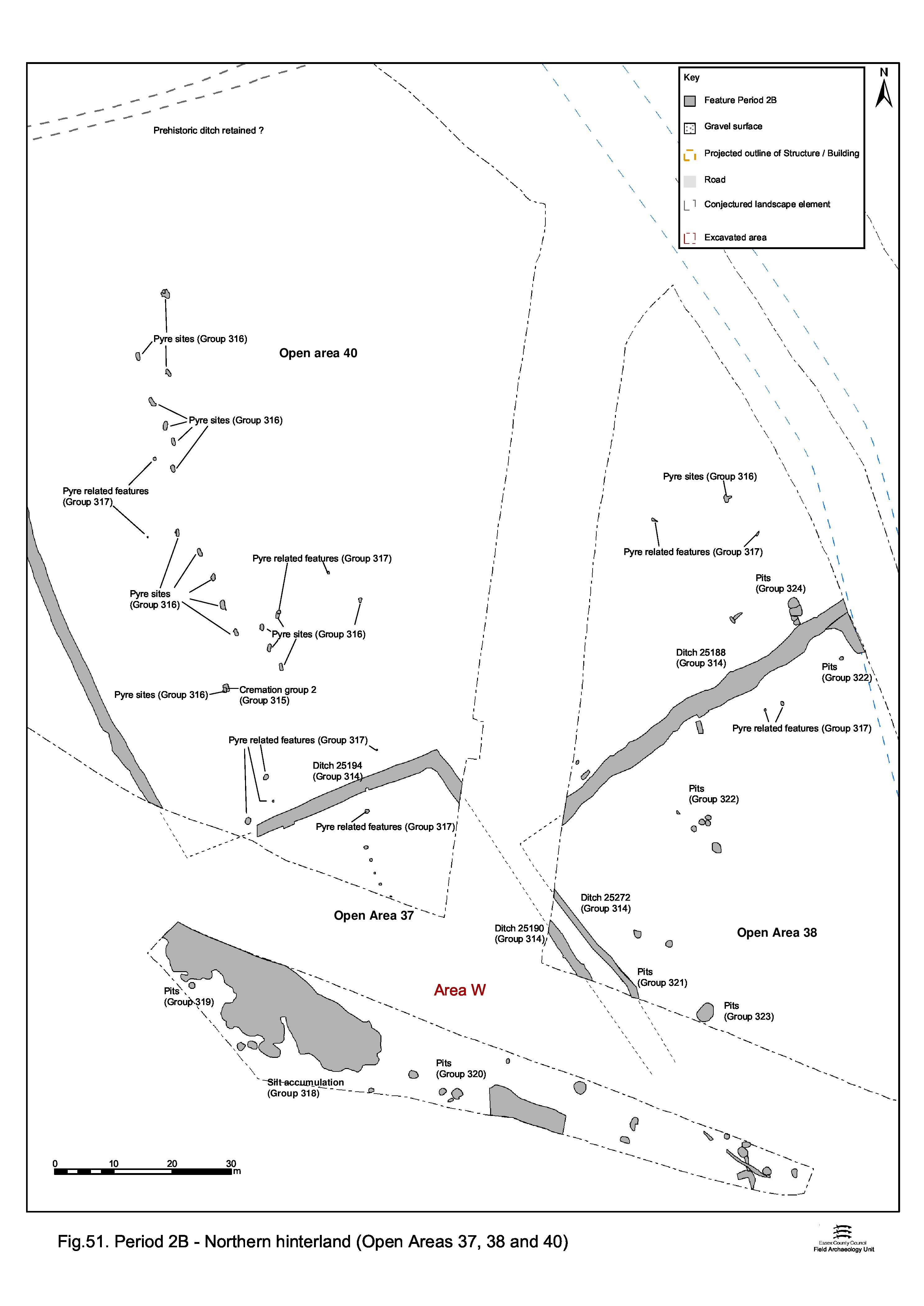
Lying on the southern edge of the upper terrace, Open Area 37 could perhaps in some ways be regarded as technically falling outside the enclosure system. As the peripheral 'left-over' of the enclosure system it is perhaps unsurprising that this triangular entity is occupied only by pitting (Groups 319, 320), most of which is located on and around the terrace step itself. These pits are unremarkable in their finds content and would appear to constitute general rubbish disposal at the very periphery of the settlement proper. The precise nature and significance of an extensive accumulated gravelly silt deposit (Group 318), also on the terrace step, is uncertain but could be the product of soil creep resulting from agricultural activities to the north. It contains pottery of the late 1st century AD in date (although there is also a later knee brooch present; SF128) and the deposit appeared to partially seal a pit (3507 Group 913, Period 4) of at least mid-2nd century AD date. It is possible that the majority of the silt accumulated in a relatively short span of time by the later 1st century AD, perhaps as wash or soil creep from the upper terrace. Its relationship with pit 3507 may be the result of continuing weathering or redeposition. Whether or not this accumulated deposit was the result of changing land-management/cultivation of the upper terrace is unclear.
Like OA37, Open Area 38 lies along the southern edge of the upper terrace and is peripheral to the enclosure system of the Northern Hinterland. However, little of its interior was investigated owing to obscuring silt (flood deposit?) and flooding. Investigation of its northern and western peripheries established the presence of generally small Period 2B pits only (Groups 322, 323). Two pits, 537 and 581 (Group 321), are judged to be associated with the pyre sites and pyre-related pits that are a prominent aspect of OA40.
OA39 is that part of the upper terrace west of major boundary ditch 25199. While its southern edge may be supposed to coincide with the terrace edge, its western and northern limits are undefined. Regardless of this, this land entity is very large; extending at least 255m north-south and 60m east-west. Occupied only by a single pit (Group 2076) in Period 2B, it is probable that OA39 functions exclusively as a field.
To the east of ditch 25199, Open Area 40 is likely to be of similar extent and primary function as adjacent OA39. If the postulated northern course of the watercourse is correct, and is accepted to define the eastern limit of this field, then an east-west width of c. 130m can be estimated. The majority of this enclosure is clear of occupying features, though a number of small rubbish pits of Period 2B date are located along its south-eastern edge, closest to the settlement. It is reasonable to assume that OA40 functioned primarily as a field. However, the southern, and particularly the south-western, part of OA40 clearly possessed an additional funerary-related function as demonstrated by the presence of a burial, pyre-field and its associated features (Figure 52).
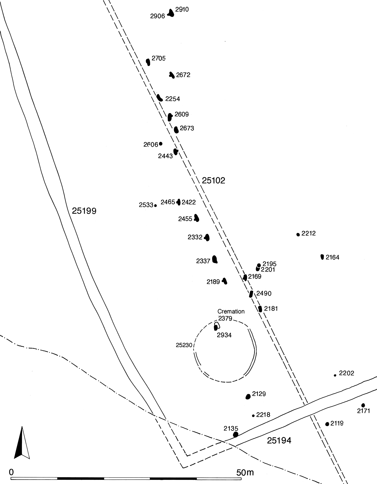
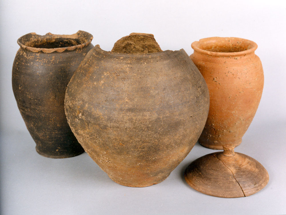
Early 1st-century AD cremation grave 2379 (Group 315), lies 10m east of former boundary ditch 25102 (Group 10, Period 2A), possibly being aligned upon it and perhaps suggesting that the earlier boundary was still functioning at the time. On the basis of its structured and relatively rich content (Figures 53 and 54), and conjectured association with ring-gully 25230 (Structure 6 Group 85, Period 2A), it appears that this is an important burial.
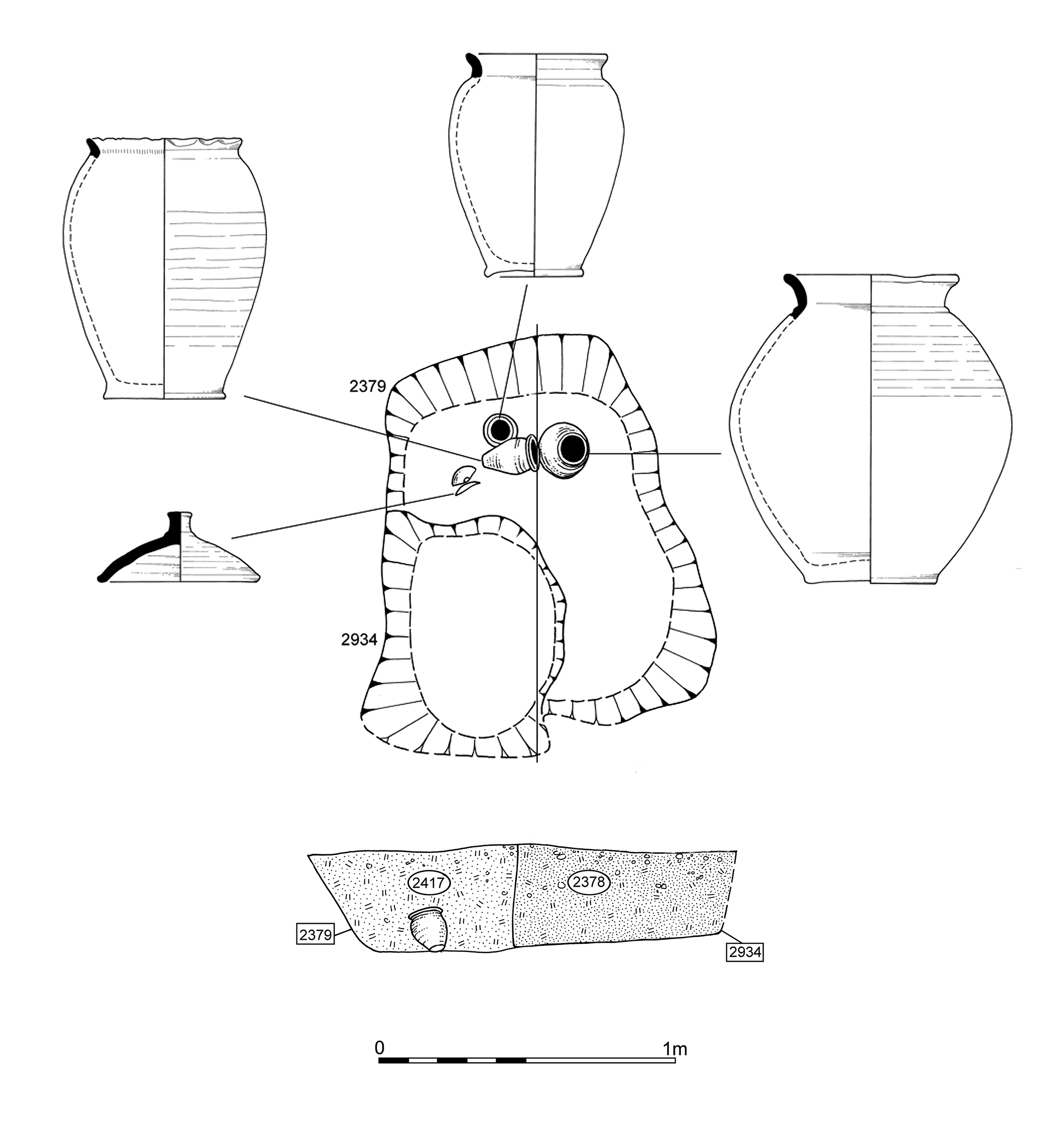
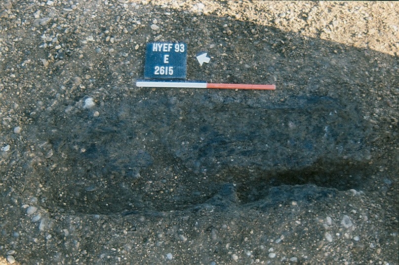
More importantly, a linear scatter of 19 pyre sites (Group 316), forming a cohesive group on grounds of spatial distribution, shape and content, extends northwards from the burial. The southernmost pyre site is positioned over the grave, which is judged to provide a point of origin for the northward spread of the subsequent pyre sites. The pyre sites date from the late 1st century BC to early 1st century AD and their remains are closely paralleled in many ways by those identified on the Westhampnett Bypass (Fitzpatrick 1997a). The extant cuts are likely to represent what is in effect a ventilation flue beneath each pyre site. The issues of structure, function and location are considered in detail elsewhere (Vol. 1, Chapter 7).
All but one of the identified pyre sites are spread out in an essentially linear arrangement over a distance of 70-90m, on a broadly NNW-SSE alignment (Figure 52). The line of Period 2A ditch 25102 clearly influences this distribution; most of the pyre sites lie close to the ditch, but three (2196, 2254, 2609) clip the infilled ditch edges and one (2181) is cut directly into its top. Although apparently out of use, this former boundary remains in some way a visible feature in the upper terrace landscape, perhaps marked by an up-cast bank. A further five pyre sites (2189, 2254, 2443, 2455, 2672) are also aligned parallel to the ditch. Most of the remainder, however, are on a more north-south alignment and it is possible that, irrespective of their individual alignments, the pyre site group is instead aligned on ES12 ditch 25199 (Group 314), which lies 25m+ to the west. The spacing of the pyre sites, particularly in the south of the group, is fairly regular and those between 2189 and 2422 almost precisely 5m centre to centre, demonstrating that they are carefully and deliberately positioned with reference to one another.

Although each pyre site is described in detail elsewhere, their remains most typically comprise elongated shallow cuts of oval or oblong shape averaging 1.3m length. An integral, small, notch-like projection in one of the long sides of the cut is a common feature, some of which are substantial enough to form an overall T-shaped plan (Figure 55). Interpreted as under-pyre ventilation flues, some contain primary silting fills, showing that the cuts probably remain open for a period of time before receiving their burnt deposits. All contain charcoal-rich deposits and in some cases the fills and even the cuts themselves show signs of in situ burning; particularly those with the integral notches. The presence of large charcoal fragments, adhering to the flue alignments and deriving from the burnt and collapsed pyre structures themselves, retain the structure of the wood and further demonstrate the in situ nature of these deposits (Figure 56). The pyre-debris fills contain generally small quantities of burnt bone, at least some of which was identifiably human. Fragmentary pottery, metalwork (including iron nails and copper-alloy brooches) and glass, most of which is burnt, is also present; clearly the remains of a range of funerary goods and/or offerings placed on the pyre. Some of the pyre ventilation flues also contain backfill or slump accumulation deposits over the burnt deposits, perhaps demonstrating that the sites were cleared and reverted to agricultural land. However, pyre site 2201 would appear to have had a secondary deposit placed within it; small round pit 2195 cuts the end of the flue and its burnt debris fills, and an unburnt flagon is placed within it. It is therefore evident that the pyre sites remain visible, at least for a short time, and are perhaps revisited though not reused.
A number of shallow oval cuts (Group 317) are located in the vicinities of the pyre sites and contain redeposited pyre debris of a similar nature to that in the under-pyre flues, albeit generally less structured and artefact-rich. These have been termed 'pyre-related pits'. Although a few (pits 2195, 2533, 2606) are located among the main linear distribution of pyre sites, most are peripheral to it, being either associated with outlying pyre sites (such as pits 513, 516 and 2212) or toward the southern enclosure boundary ditches 25188 and 25194 of OA40. As illustrated by the previously mentioned pyre-related pit 2195, all these pits need not have had the same specific function and some (such as 2119, 2533 and perhaps 2135) could perhaps be pyre sites in their own right. Pit 3585 is the most distant from a pyre site and its assemblage of burnt artefacts, along with 2195, displays the greatest similarity with those from the pyre sites themselves. Though of differing scale, the broad similarities of these features and their contents to those of pit 15417 (Group 33 Period 2A) should be noted and are clearly parts of the same Late Iron Age practice of disposal of pyre debris, even if not directly contemporary. Further discussion of the significance of the pyre-related pits to the understanding of Late Iron Age funerary practice is presented in Vol. 1, Chapter 7.
At the eastern end of the lower terrace (Excavation Area Q/Development Area A4), the north-south aligned ditches of Period 2A are replaced by two substantial, repeatedly re-cut, boundaries, denoted by ditches 25099 (Group 327, 329, 330) and 25181 (Group 328, 331), running almost east-to-west, c. 15m apart (Figure 57). These boundaries are believed to define part of a wider Enclosure System 13 (ES13).
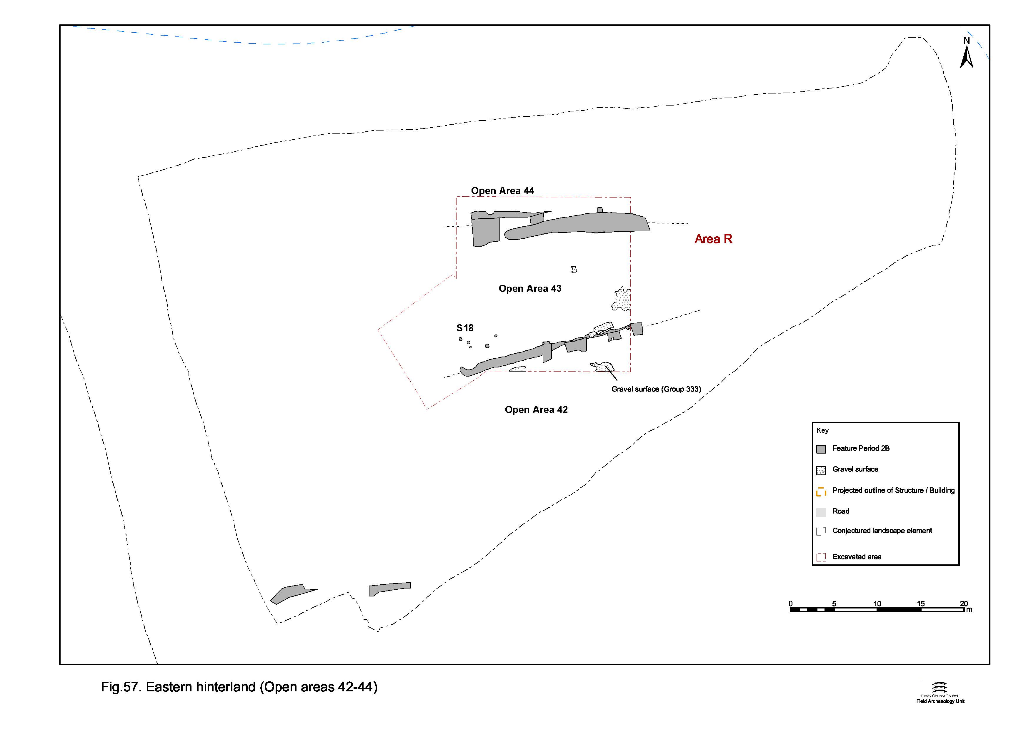
Located somewhat away from the settlement core, and divorced from the rest of the excavated settlement area by uninvestigated Development Area A3 (Figure 6), this vicinity is termed the 'Eastern Hinterland'. However, during Period 2B this may not be wholly appropriate. It is possible that ditch 25181 flanks an eastward continuation of either Road 3 or 4 (which may in any case have converged by this point). Similarly, ditch 25099 may flank Road 5 (if this were the case, the lines of Roads 3/4 and 5 can be postulated to converge some 400m east of Road 1). It is, however, difficult to trace road/tracks and roadside ditches across Area A3 with any great degree of confidence.
If this is indeed the case, the three land entities (Open Areas 42-44) defined by the boundaries in fact constitute the eastern extremes of those in the Central and Northern Zones to the west (principally OA19). However, given the relatively high degree of uncertainty and displacement, the grouping of these within the Eastern Hinterland construct is maintained. That much of this investigated vicinity contains road/tracks may well account for the paucity of occupying features of Period 2B date within the three 'enclosures'.
Lying south of ditched boundary 25181, OA42 could be construed as containing merged Road/tracks 3 and 4 with the remainder lying within the Southern Settlement Zone. Only the very northern edge of OA42 was investigated. Post- and stake-holes alongside the ditch (Group 2073) suggest that the roadside was fenced.
Open Area 43, being defined between ditches 25099 and 25181, could perhaps be regarded as the eastern end of OA19. Possibly surfaced (Group 333), the majority of its exposed interior is free of Period 2B features, though tentative Structure 18 is construed from a cluster of post-holes (Group 332) alongside the southern boundary. However, its lack of cohesive plan and non-conforming alignment may cast doubt on its construct. A scatter of poorly dated pits, other post-holes and stake-holes (Group 2072) may also occupy the enclosure, but display no patterning or insight into the function of this vicinity of the transition-period settlement.
Open Area 44, to the north of ditched boundary 25099, could therefore contain the eastward course of Road/track 5, and any further part of it to the north may be within the Northern Settlement Zone. Only the southernmost edge of the enclosure interior falls within the excavated area and contains no Period 2B features.
Internet Archaeology is an open access journal based in the Department of Archaeology, University of York. Except where otherwise noted, content from this work may be used under the terms of the Creative Commons Attribution 3.0 (CC BY) Unported licence, which permits unrestricted use, distribution, and reproduction in any medium, provided that attribution to the author(s), the title of the work, the Internet Archaeology journal and the relevant URL/DOI are given.
Terms and Conditions | Legal Statements | Privacy Policy | Cookies Policy | Citing Internet Archaeology
Internet Archaeology content is preserved for the long term with the Archaeology Data Service (ROR). Help sustain and support open access publication by donating to our Open Access Archaeology Fund.