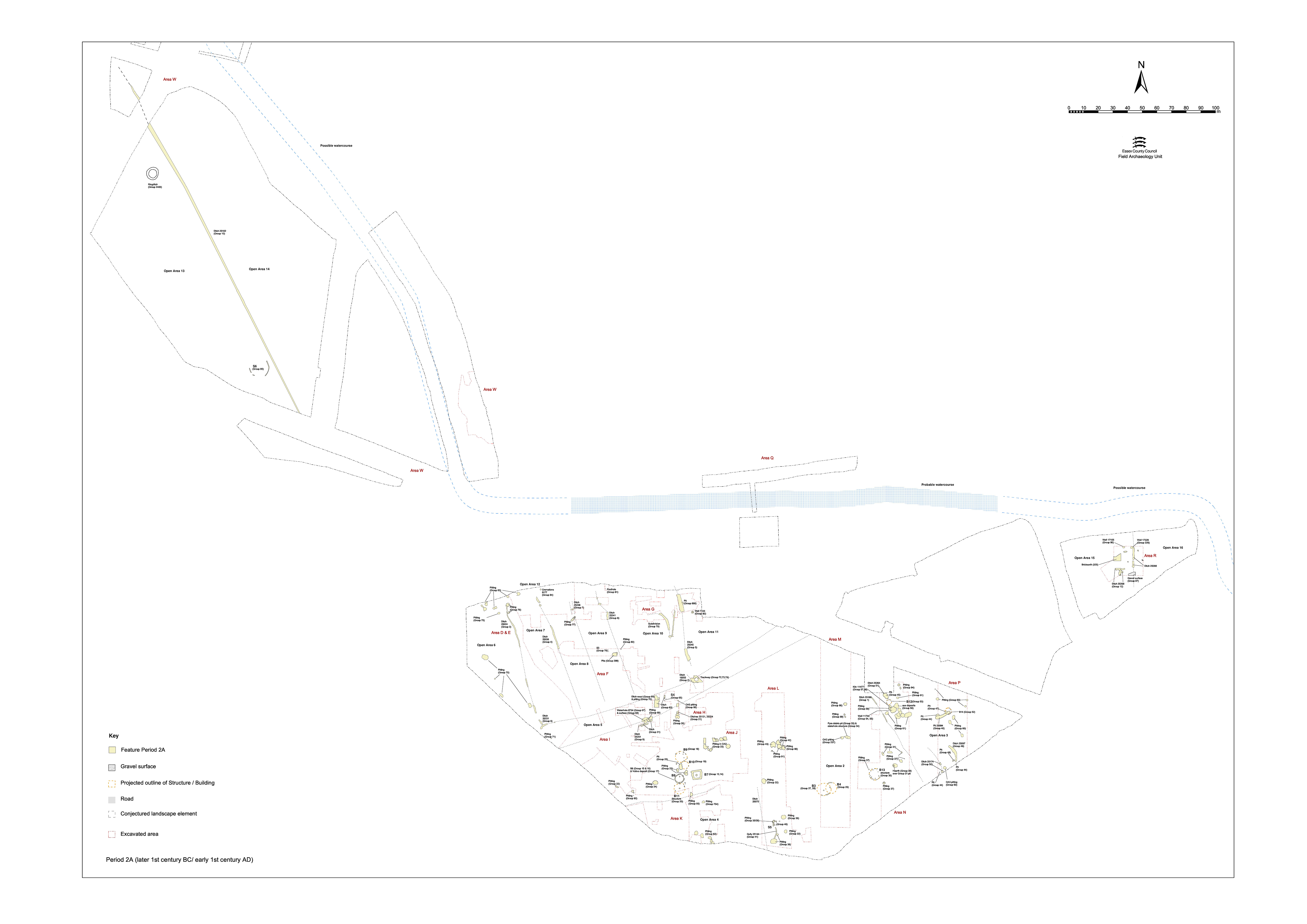
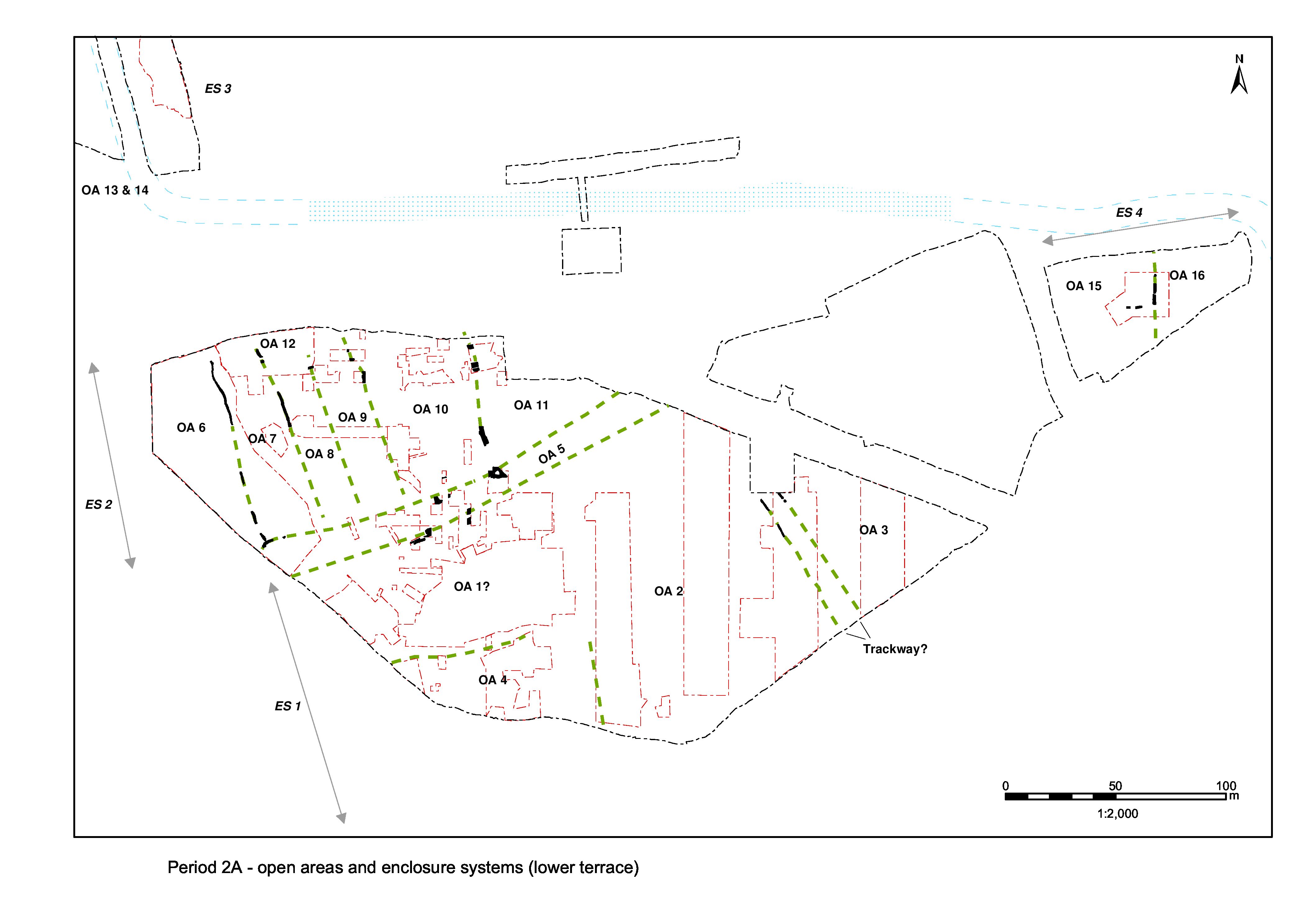
South of the postulated trackway of OA5, the lower terrace is seemingly divided into landscape units (Open Areas 1-4 and 15-16), though in a far less regular layout than is evident to the north of OA5 (Figure 8). The boundary features that define this division are fragmentary and sparse and to some extent conjectural. For instance, Open Area 1 lacks any clear limits to the east, west or south and could be regarded as part of OA4. However, the clustering of buildings and associated features at this location, and the knowledge that these later develop into a clearly defined religious focus, are judged to warrant its distinction, albeit this is somewhat speculative.
In overview, a series of relatively large land units are defined across the lower terrace, mostly extending from the posited OA5 trackway in the north to the terrace edge in the south. Probable elements of this enclosure system are identified as far as the eastern investigated extent of the site (in Excavation Area Q) and must be presumed to extend across the intervening uninvestigated Development Area A3. The various defining boundaries are described from west to east.
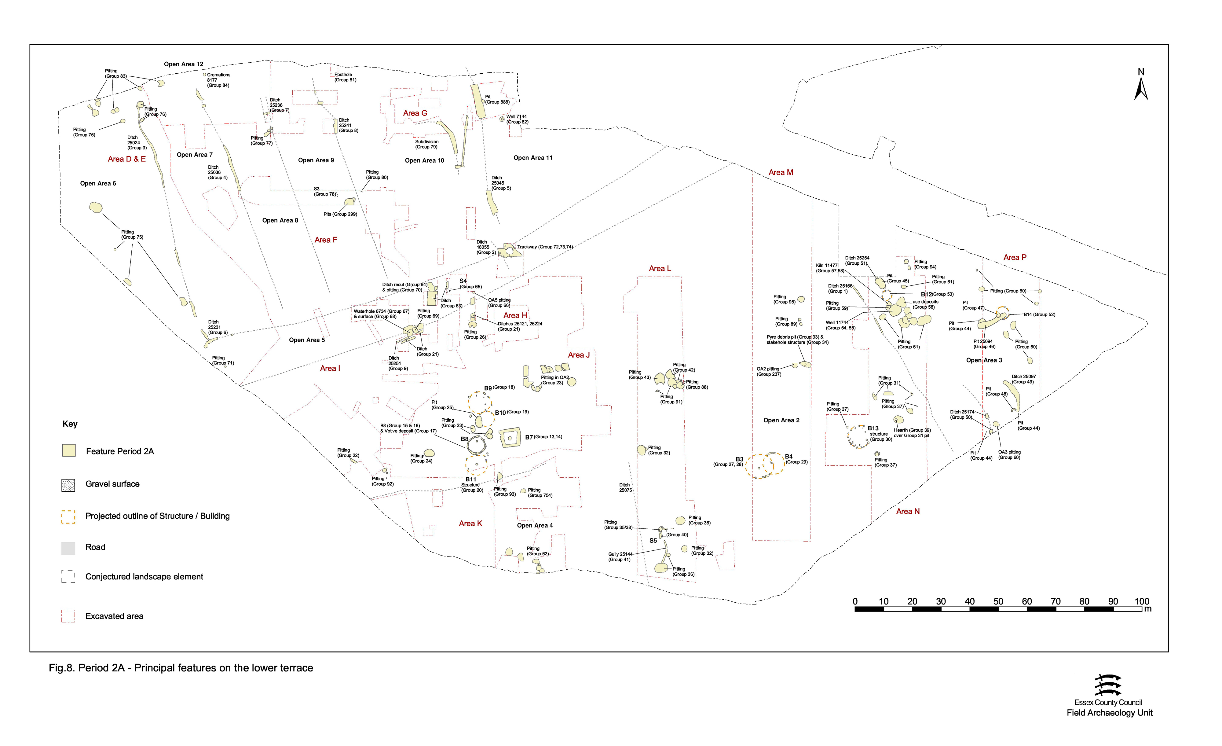
Activity within the enclosures defined by this system of land division is described in the following:
Ditch 25075 (segs 14557, 14798, 14832, 14836, 14954) runs on a NNW-SSE alignment and is traced for a distance of almost 18m (in Excavation Area L). The cut is 0.8-0.9m wide and 0.33-0.38m deep. Although regarded as a component of the succeeding Period 2B landscape, the alignment of this ditch is not orthogonal to the other elements of the Period 2B enclosure system, which may suggest that in origin it belongs to an earlier phase of land division. It is therefore suggested that ditch 25075 is a remnant of the Period 2A landscape, and so represents the boundary between OAs 2 and 4. The ditch fills contain a small assemblage of pottery, animal bone and baked clay/daub of Late Iron Age date, though as some re-cutting is evident this material may well derive from its later life. But see Period 2B, Group 143
Some 100m to the east of ditch 25075, ditch 25166 (segs 11726, 11776) runs on more of a NW-SE alignment (as investigated in Excavation Area N). The northern extent extends under the line of later Road 3 (Period 2B) and was not investigated. South of this, although heavily truncated by later ditches and pits, it is traced for a total of 18m, but it is not certain whether the feature represents a continuous or interrupted length of ditch. At c. 0.80m wide and 0.44m deep, with steep sides and a flat base, it is extensively truncated by its apparent Period 2B replacement ditch 25092 (Group 148 Period 2B). This ditch is interpreted as the boundary between OA2 to its west and OA3 to its east.
The intrinsic dating of 25166 is poor and its interpretation as a Period 2A feature depends upon the fact that ditch 25166 stratigraphically pre-dates Road/track 3 and enclosure ditch 25092, both of which are within Period 2B. However, it is noticeable that the Period 2A pits in this part of the site respect its line and do not overlie it.
Ditch 25174, which has been classed as a feature occupying the interior of OA3, could instead perhaps have been included here as a potential alternative to 25166 as the enclosure boundary.
The same can be said for ditch 25264, a c. 6m length of ditch that is on the same alignment as, and presumably related to, ditch 25166.
Linear cut 25098 (segs 17208, 17353, 17362) comprises two short, shallow lengths of interrupted ditch, c. 1.2m wide and up to 0.52m deep, separated by a 0.6m-wide gap. No further parts were identified to the north or south. Although aligned due north-south, it is interpreted as the easternmost (i.e. in Excavation Area Q) recorded element of the enclosure system that extends across the lower terrace south of OA5. As such, it denotes the boundary between OAs 15 and 16.
Internet Archaeology is an open access journal based in the Department of Archaeology, University of York. Except where otherwise noted, content from this work may be used under the terms of the Creative Commons Attribution 3.0 (CC BY) Unported licence, which permits unrestricted use, distribution, and reproduction in any medium, provided that attribution to the author(s), the title of the work, the Internet Archaeology journal and the relevant URL/DOI are given.
Terms and Conditions | Legal Statements | Privacy Policy | Cookies Policy | Citing Internet Archaeology
Internet Archaeology content is preserved for the long term with the Archaeology Data Service (ROR). Help sustain and support open access publication by donating to our Open Access Archaeology Fund.