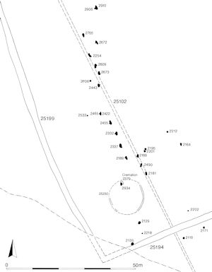
Open Area 40 (Figure 52) is defined by major boundary ditch 25199 to the west and by ditches 25194 and 25188 to the south. Its eastern limit is not readily apparent, but it is conjectured that, as for OA38, the northward extension of the watercourse constitutes this. Its northern boundary is not established.
As exposed within Excavation Area W, OA40 is the largest land entity identified. Most probably a field, being one of the nearest of the Northern Hinterland enclosures to the settlement core, it undoubtedly has some increased significance/function. This is evidenced by the presence of a relatively elaborate burial and the remains of an extensive pyre-field comprising nineteen identified pyre-sites. A range of pyre-related pits and other miscellaneous pits are described in Northern hinterland, Open Area 40.

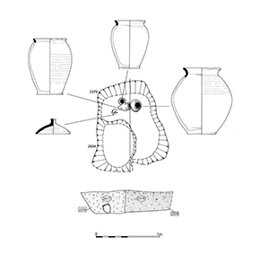
Rectangular grave cut 2379, 1.55m by 1.14m and 0.25m deep, contains an assemblage of three ceramic vessels and a lid, all positioned at its north end (Figure 53). The largest vessel, jar 2483, contains a quantity of cremated human bone (392g). A further, smaller, amount is present in one of the backfills. The ancillary items are placed to its west. While the three vessels are complete, the lid is broken in two. The northern half of the grave, around the cremation assemblage, is backfilled with a clean orange-brown sand silt 2417, which contains occasional charcoal flecks and small cremated bone fragments throughout (44g). The southern half is backfilled with a pebbly mid-brown silty sand that overlies the northern fill at their interface.
Located toward the corner of OA40, this grave would appear to be broadly contemporary with the pyre sites that also occupy this enclosure. However, being the most southerly and westerly of these funerary features, 2379 could be construed as being the earliest, providing a point of origin for the northward spread of subsequent pyre sites. Furthermore, aligned roughly NNW-SSE, the cut is parallel to Period 2A ditch 25102 (Group 10) which lies 10m to the east, perhaps suggesting that this boundary is still functioning or at least visible. The structured and relatively rich content of the burial and its conjectured association with ring-gully 25230, suggest importance and status. The burial may provide a focal point and perhaps be marked by a small mound over it; some form of visible marker must be present to allow the positioning of pyre site 2934 on top.
A total of nineteen pyre sites (526, 2164, 2181, 2189, 2196, 2201, 2237/2908, 2254, 2332, 2422/2465, 2443, 2455, 2490, 2609, 2672, 2673, 2705, 2906/2910, 2934) occupied the interior of OA40. Almost all are located toward the south-west corner of the field and clearly aligned both on boundary ditch 25199, c. 25m to their west, but also on Period 2A ditch 25105 into which a number of them are cut. The exception is pyre site 526, which is an isolated example located some 80m east of the main group.
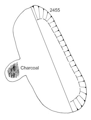
In essence, each pyre site is denoted by a relatively small, roughly oblong cut. Many display a characteristic 'notch' in one side, some of which are long enough to produce something of a T-shaped plan overall, as with pyre 2455 (Figure 55). All contain a range of burnt debris that is characteristic of pyre material - comprising fuel, human remains and pyre goods. Cuts 2254 and 2332 display traces of in situ burning or scorching. A number also appear to contain primary silting fills (e.g. pyre sites 526, 2237/2908, 2490, 2672), suggesting that the cuts were left open for a time to allow weathering to occur.
These distinctive features are interpreted as under-pyre air ducts or flues and have a close parallel with the Westhampnett Bypass pyre sites (Fitzpatrick 1997a). The overlying pyre structures are presumed to have been surface-built and consequently no trace of their above-ground extents remain, having been removed by later (and perhaps contemporary?) agricultural activity.
While further description and discussion of their significance is presented in Atkinson and Preston (2015), Chapter 7) and details of artefact assemblages in FF14, a description of the general morphology of these important remains is given below for each pyre site.
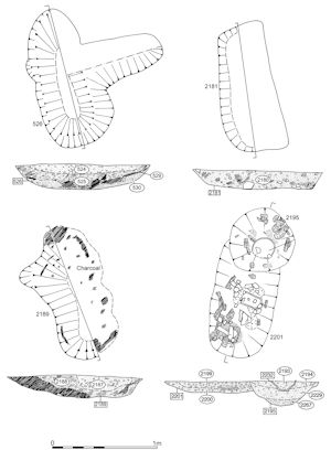
Roughly fashioned, rounded, T-shaped cut, just over 1.0m in each direction and 0.25m deep, with a very rounded profile (Figure 61). The side 'arm' is shallower than the main section. Of the four fills, the first may just represent weathering of the sides, the second is a near-continuous layer of charcoal, the third is closely bound up with the second and includes a lot of charcoal, burnt pebbles and most of the finds, while the final one is post-use accumulation. Finds include heavily burnt pottery, slag (31g) and a lava quern fragment.
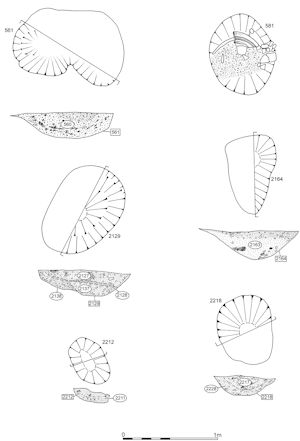
Irregular ?oblong cut, 0.85m by 0.55m and 0.3m deep (Figure 62). Single fill with charcoal concentrations, containing a horizontal charred timber. Contains two small pottery sherds (grog- and sand-tempered, burnt?) and many burnt pebbles.
Oblong cut, 1.25m by 0.6m and 0.18m deep (Figure 61). Single charcoal-rich fill including burnt pebbles. Contains grog-tempered sherds, probably from two vessels. Soil sample 93.
Oblong cut, 1.3m by 0.8m and 0.2m deep, with integral notch on western edge (Figure 61). Two charcoal-rich fills including burnt pebbles and white flecks, which are probably cremated bone. Large charcoal fragments, up to 8cm long, noted to lie against the sides of the cut; interpreted as collapsed pyre fuel. Contains grog-tempered pottery and Cam 165 flagon sherds (all of which are burnt), two flint blades and a flake. Soil samples 94 and 96.
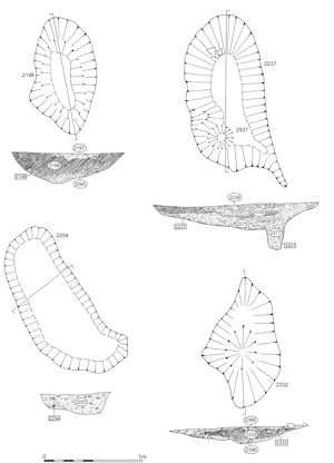
Slightly irregular, oblong cut, 1.2m by 0.66m and 0.31m deep, with notch on western edge (Figure 63). Three charcoal-rich fills including burnt pebbles. Also contains a single bone fragment (1g) and a terra nigra bodysherd, both burnt, and a flint flake. Soil samples 148 and 149.
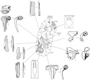
Truncated oblong cut, 0.8m+ by 0.5m and 0.13m deep (Figure 64). North end cut by pyre-related feature 2195. Three charcoal-rich fills including burnt pebbles. Also contains human bone (593g ), the lower part of a burnt grog-tempered jar and four or five brooches, some burnt, and an iron nail (SF95). Burnt Dr 1 amphora sherds in top fill. Soil samples 123 and 127.
Slightly irregular oblong cut, 1.76m x 0.8m and 0.5m deep, with a 'tail' extending off to the south-east (Figure 63). Also possible trace of a notch on its western side and an integral deeper 'cut' 2931 at its south end. Five fills, the upper two charcoal-rich with burnt pebbles. Contains a tiny amount of burnt bone (<2g), burnt Dr 2-4 amphora sherds and a copper-alloy brooch. Soil samples 116-20.
Slightly irregular oblong cut, 1.6m by 0.8m and 0.25m deep (Figure 63). Single charcoal-rich fill including many burnt pebbles. Possible traces of in situ burning. Contains human bone (88g) and parts of a grog-tempered bowl, both burnt. Cut into Period 2B ditch 25102. Soil sample 138.
Irregular ?oval cut, 1.3m by 0.8m and 0.17m deep with possible wide notch on west side (Figure 63). Really a truncated oblong cut with a two-level base? Base and sides of the cut scorched and reddened, suggesting in situ burning. Three charcoal-rich fills with burnt pebbles. Contains human bone (1g), base and body sherds of a grog-tempered vessel and two copper-alloy brooches toward the north end of the cut, all of which are burnt. Soil samples 143, 144 and 145.
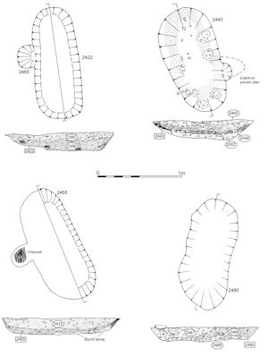
Oblong cut, 1.3m by 0.5m and 0.27 deep (Figure 65). Notch on west side initially mistaken for a separate cut, 2465. Stepped base. Two charcoal-rich fills containing many burnt pebbles. Tiny amount of burnt bone present (<2g) and a small glass sherd. Soil samples 147 and 157.
Pyre site 2443
Oblong cut (Figure 65), 1.25m by 0.65m and 0.25m deep, with integral notch on eastern edge (pre-excavation plan may hint at a notch on west side too). Five charcoal-rich fills containing many burnt pebbles. Contains dispersed burnt human bone (83g), burnt sherds of grog-tempered, early shell-tempered and terra nigra pottery, baked clay, iron plate (SF131), slag (240g). Soil samples 166-170.
Oblong cut, 1.4m by 0.6m and 0.18 deep (Figure 65). Two fills; lower is charcoal-rich and includes burnt pebbles. Contains burnt human bone (421g), burnt grog-tempered base and wall sherds from a single vessel, a burnt flint flake and a glass sherd. Mostly toward north end of cut. Soil samples 150 and 153.
Oblong cut, 1.3m by 0.5m and 0.22m deep (Figure 65). Four fills, upper ones charcoal-rich including burnt pebbles. Contains burnt human bone (445g) (also ?animal), small burnt grog-tempered and burnt Dr 2-4 amphora sherds and a copper-alloy brooch (SF133). Soil sample 155.
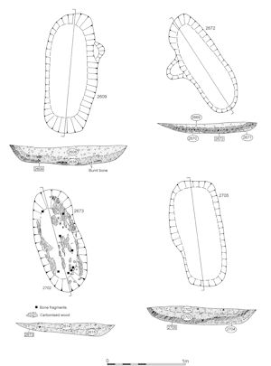
Oblong cut, 1.45m by 0.55m and 0.25m deep, with notch on eastern side (Figure 66). Two fills, the lower charcoal-rich including burnt pebbles. Contains burnt human bone (103g) and slag (334g). Soil samples 180 and 183.
Oblong cut, 1.4m by 0.5m and 0.16m deep, with integral notch on the western side (Figure 66). Three fills, the upper ones charcoal-rich including many burnt pebbles. Contain burnt human bone (32g), a daub fragment and two iron nails. Soil samples 191 and 192.
Slightly irregular oblong cut, 1.3m by 0.6m and 0.15m deep (Figure 66). Two charcoal-rich fills including many burnt pebbles. Also contains a flint burin, burnt human bone (112g) and much iron corrosion/panning that may be poorly surviving objects. Large lumps of charcoal retaining their wood structure line the sides of the cut. Soil samples 184 and 198.
Oblong cut, 1.3m x 0.6m and 0.22m deep, with a slight bulge on western side; possibly a notch (Figure 66). Three charcoal-rich fills including many burnt pebbles. Contains burnt bone (26g), three iron nails and a flint flake. Soil samples 200 and 201.
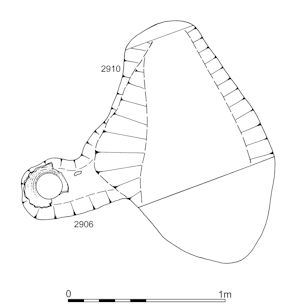
Irregular oblong cut, 1.6m by 1.0m, with pronounced notch on western side (Figure 67). Two fills, lower charcoal-rich with burnt pebbles. Contains burnt bone (2g), burnt grog-tempered and butt beaker sherds; large base sherd in the notch. Soil samples 246 and 262.
Oblong cut, 0.8m by 0.6m and 0.28m deep (Figure 53). Cut into top of cremation burial 2379, apparently following its western edge. Two fills, lower charcoal-rich including burnt pebbles. Contains burnt human bone (262g), copper-alloy fragments (SF118 and 119), burnt grog-tempered pottery and a flint flake. Soil sample 136.
Internet Archaeology is an open access journal based in the Department of Archaeology, University of York. Except where otherwise noted, content from this work may be used under the terms of the Creative Commons Attribution 3.0 (CC BY) Unported licence, which permits unrestricted use, distribution, and reproduction in any medium, provided that attribution to the author(s), the title of the work, the Internet Archaeology journal and the relevant URL/DOI are given.
Terms and Conditions | Legal Statements | Privacy Policy | Cookies Policy | Citing Internet Archaeology
Internet Archaeology content is preserved for the long term with the Archaeology Data Service. Help sustain and support open access publication by donating to our Open Access Archaeology Fund.