Summary | Period 0-1 | Period 2 | Period 3 | Period 4-5
Plan of Saxon features | Plan of Medieval features | Plan of Site B
Palisade trench | Inner ditch | Outer ditch | Intra-mural ditch | Period 5
After the span of time represented by period 3B, the defences were refurbished by the addition of four major elements:
All these elements can be recognised from previous excavations across the defences - see Part 2. This evidence shows that the refortification of this period was carried around all four sides of the former defences. It is argued in Part 3 that this episode can be directly connected with the construction of a 'castellum' at Cricklade by William of Dover in 1144.
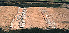
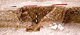
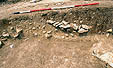
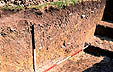
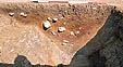
This was observed in every trench excavated along the line of the front of the former bank, and in plan over Areas 1, 2 and 2a immediately underneath the topsoil. It was of irregular profile and depth, though generally U- or V-shaped, sometimes extending down to or below the level of the base of the earlier wall. In all places it cut through the destruction deposits of the wall of period 3. See section 1, section 2, section 4 and section 5. In Area 3, where the deposits were shallowest, its presence was recognised mainly by the presence of a narrow and shallow zone along the centre of the wall where the stones of the latter had been disturbed [3/8]. However, the feature was clear in plan over the western side of Area 2 - see photo 2/12 (and the same feature showing in the cleaning of the machine-cut trench on the bottom right corner of this picture). It was generally filled with dark clayey earth mixed with stones, and a little mortar derived from adjacent deposits. Only three short sections of the palisade trench were completely excavated, in Areas 1 and 2. In all of them there were at least two phases of post-holes present.
 3/8
3/8
 2/12
2/12
 2/11
2/11  2/10
2/10
 1/22
1/22 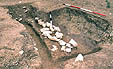 1/20
1/20
 1/8
1/8 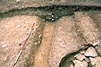 1/9
1/9
 1/26
1/26 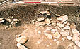 1/28
1/28
On the western side of the defences the inner ditch of periods 1 and 2A and 2C, filled in period 3B, was recut in a V-shape (see section 6 and section 7). There is, however, no direct stratigraphical evidence that this recut is contemporary with either the palisade trench or the outer ditch (below), and so its inclusion as one element in the refortification attributable to period 4, although highly likely, must remain a matter of inference. In trench 6 the Saxon ditch had been recut twice [554, 555], which parallels the recut of periods 4A and 4B observed on the outer ditch. In trench 7, however, this secondary recut [627] was not observed.
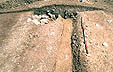
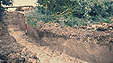
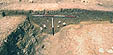
On the south side of the defences the outer ditch crossed the line of the earlier ditches obliquely, an alignment probably conditioned by the steeper slope on this side. If its alignment is extended eastwards beyond the eastern edge of trench 1, it would cut into the front of the line of the palisade and earlier bank. It took a course around the corner to lie on the west of the defences (Area 2c) outside the outer edge of the wide outer ditch of periods 1 and 2 [2/13]. A short length excavated by hand showed a shallow profile 1.2m deep from the base of the present topsoil, and with a narrow gully at its base towards its northern edge. Elsewhere (section 1, section 2, and section 4) it showed the same profile, and cut into the pile of stones and mortar deposited on the berm in period 3. Its filling was generally of dark brown gritty humus, with lenses of small stones and mortar eroded from the deposits it cut. In places (section 1 and section 4) it was clear that it had been recut at a shallower level at least once (period 4B). From its similar stratigraphical relationships to the overlying topsoil and the underlying destruction deposits of period 3, it seems likely that the ditch is of the same phase of construction as the palisade trench.
 2/35
2/35
 2/13
2/13
There was evidence from the excavations that the fill of this ditch on the western side was deposited possibly as a low bank on its inner edge. On removal of the topsoil in this area by machine, an area forming a line about 2.5m wide on the inside the line of the ditch was observed to be be discoloured with iron-staining. It was inferred that this was where at least some of the material from the ditch had been dumped during its excavation to form a slight bank. It is uncertain whether this was intended to form any sort of structure associated with the defensive arrangements marked by the palisade and ditches.
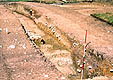
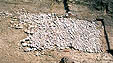
A ditch 2.5m in width and 1.5m in depth at its lowest point was located in Area 1 [1/11, 1/25, 1/24, 1/14]. It ran parallel to, and was cut into, the rear of the bank (section 1). Its filling [31, 38; 48, 49] of dark brown clayey, gritty humus showed evidence of a recut [12], which was filled with darker material [16, 14]. The similarities to the outer ditch in its fill, its dual phasing, and its relationship to the earlier bank suggests that it belongs with the refurbishing of the defences in period 4. It was unfortunately not possible to determine how far or in what direction it extended westwards in Area 1 (i.e. towards the internal corner). The fact that it was not present in any of the other trenches raises the possibility that it could represent the fortification of an inner area or building occupying the higher ground around Parsonage Farm, possibly as a temporary motte and bailey structure.
 1/25
1/25
 1/24
1/24
 1/14
1/14
Reassessment of the evidence for the existence of features of this period in earlier excavations at Cricklade.
Discussion of the historical context for this period.
This is a long period represented by the abandonment and decay of the defences of period 4B, up to 1975. The bank becomes considerably eroded over the centuries, mainly caused by cultivation. In the south-west corner the western bank is used as a ridge, and the southern bank as a headland, in a ridge and furrow system. The line of the outer (western) medieval ditch is preserved as a hedge and ditch enclosing a long 'croft' as a field between it and the defensive bank, which is also in part preserved in other parts of the western defences by a hedge line. It is of interest that the line of the outer medieval ditch marks the line of the later borough boundary on the western side of the town (shown on the map of Cricklade drawn in c. 1780).
Of interest in this period is a late medieval or post-medieval cattle pond, cut into the inner edge of the southern Saxon/medieval bank [1/40, 1/41, 1/42, 1/43]. The fill of the pond was not excavated to any great depth, but the interesting stone ramp sloping down to the edge of the pond to its east was cleared completely. It consisted of flat stones laid at an angle pointing down the ramp, and clearly acted as an anti-slip device for cattle using the pond. There was no evidence for its date of construction, but it could belong to any period between the later medieval period and the later post-medieval period. That the pond was not visible as an earthwork in the field before excavation implies that it had been abandoned for some time before its discovery. and therefore belongs to the earlier part of this period.
 1/40
1/40 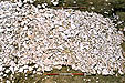 1/41
1/41 .jpg) 1/42
1/42 .jpg) 1/43
1/43
Summary | Period 0-1 | Period 2 | Period 3 | Period 4-5
© Internet Archaeology
URL: http://intarch.ac.uk/journal/issue14/1/excavations-per4-5.htm
Last updated: Mon Jul 7 2003