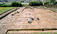
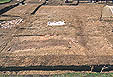
Summary | Period 0-1 | Period 2 | Period 3 | Period 4-5
Note: Areas, trench and section numbers used are given in Figure 4. Where they appear in the text, context numbers are given thus [543] and are also given on the sections. They are described in a separate table. The photographs are referred to in the text thus [2/36] - denoting the area number and image number.
Plan of Saxon features | Plan of medieval features | Plan of Site B
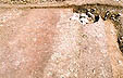
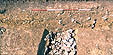
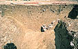
One of the general aims of the excavation on the defences was to examine the ground surface sealed underneath the clay bank for evidence of ploughing or other activity. However, the exceptionally dry conditions during the whole course of the excavation prevented this objective being achieved, except in a small trench in Area 2, which was trowelled to below the level of the subsoil [2/36, 2/37]. The latter's surface was observed to be very irregular, and there was no indication either of a buried turf-line or of any regular lines indicating ploughing. Its patchy appearance is more consistent with the effect produced by the stripping of turf with a spade, the superimposed clay of the bank having become pressed into the resulting hollows. The sections, none of which showed a recognisable turf line, reinforced this conclusion.
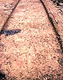 2/36
2/36 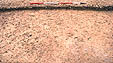 2/37
2/37
This conclusion is supported by the fact that the material comprising the front of the bank, and assumed to be stacked turves (see below - period 1), was of a dark brown gritty material dissimilar to the surviving material under the bank, but very similar to that remaining under the intra-mural walkway (see below) which was raised up above the level of the base of the bank. From these observations it can be inferred that turves for use in the construction of the bank had been stripped from the whole area of the bank, berms and ditches, except for the narrow zone immediately underneath the intra-mural walkway. It follows that any irregularities in the thickness of the soil buried under the bank cannot, as Radford (1972) has suggested (see Part 2), be taken as direct evidence of either the presence, absence or the nature of agricultural activity earlier than the bank.
Plan of Saxon features | Plan of medieval features | Plan of Site B
The bank | Intra-mural walkway or wall street | Corner turret | The ditches, inner ditch | centre ditch | outer ditch
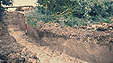
The Saxon and medieval bank has clearly been considerably degraded by ploughing since its abandonment in the later 12th or 13th century. On the western side of the defences, it had survived to no more than 0.4m in height (section 6 and section 7); but on the southern side up to 0.9m survived (section 1, section 2, section 4 and section 5) due mainly to its use as a headland for ridge and furrow ploughing.
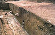
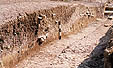
The bank was constructed of two main components: redeposited Oxford clay, and a gritty layer with high humus content. The latter formed layers, lenses or stacks, which varied in colour from light to dark reddish-brown according to the proportion of organic matter. This was probably deposited in the form of turves. The clay, which it can be assumed was derived from the three external ditches, formed a central dump around which the turf had been stacked in an irregular fashion. The turf component formed a substantial revetment at the front of the bank, and a slighter revetment to the rear. The front revetment in particular tailed off in an irregular fashion into the body of the bank, in many places forming distinct layers interleaved with clean clay (see section 1, section 2, section 4 and section 5) [2/5, 1/23, 1/17, 1/10, 2/25]. This turf revetment had been cut back by up to 1.6m for the insertion of the stone wall in period 2 [1/23] (see part 2). The rear edge of the bank had in several places been similarly revetted with turves, though on a slighter scale. In one place on the west side near the corner, the bank incorporated a turf stack some 1.5-2m in width running from front to rear of the bank, of uncertain function [2/12]. There was no evidence of the presence of timber strapping or other reinforcement at any position or level within the bank.
 2/24
2/24
 2/12
2/12
 2/23
2/23
 2/5
2/5
 1/23
1/23
 1/17
1/17
 1/10
1/10
 2/27
2/27
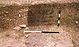
There were slight indications in several places on the southern defences of a feature or series of features cut into the pre-bank subsoil on a line with the front edge of the wall. Nowhere was it possible to excavate this in plan. However, in Area 1, which was the only area where the surface underlying the wall was seen in plan, this was not observed [3/13]. In trench 2, on the west side of the bank, no such feature was observed, due partly to the difficulties of excavating sun-baked clay. This feature could possibly have represented a trench for a palisade of vertical timbers set into the ground or onto a sleeper beam. However, since the front course of stones of the wall, where observed, were invariably placed within this trench, a more plausible suggestion for its function is that it was a trench dug to mark out and stabilise the front edge of the stone wall added in period 2A. This hypothesis is strengthened by the fact that this feature was absent on the flat area of Area 3 [3/13], but present on the relatively steep-sloping south side (see further discussion in Part 2).
 3/13
3/13
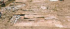
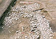
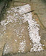
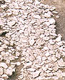
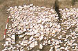
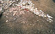
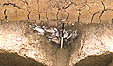
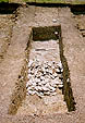
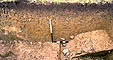
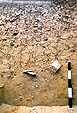
Defining the inside edge of the bank, and forming an acute angle within its corner, was a layer of worn flat stones. The whole feature varied in width between 1.5 and 1.8m. This was observed in Area 2 (see section 4 and section 6) [2/21, 2/22, 2/20, 2/21a], and Area 2a. Elsewhere it was eroded or robbed (section 7 - not shown), or in Area 1 destroyed by later features (the intra-mural ditch of period 4). Enough remained, however, to show that it continued around the inside of both the western and southern defensive bank. The stones were small flat slabs of Oolitic Limestone (from the Cornbrash or Forest Marble series which outcrop to the north of Cricklade), between 100-300mm in diameter or length, laid inconsistently in one or two layers on a layer of dark brown gritty soil (see section 4 and section 6) 2/14-16]. The upper surfaces of the top layer of these were worn smooth, whereas their undersides were completely unworn.
This evidence shows clearly that this feature was a pathway which had been subjected to considerable use, probably over a period of several decades. It can be inferred from the fact that the soil under the stones was thicker and darker than the soil sealed beneath the bank that the pathway was laid on undisturbed turf before it was stripped from the area under the bank, as well as probably from the site of the berm and ditches. The implications of this will be discussed further in Parts 2 and 3.
 2/21
2/21
 2/22
2/22 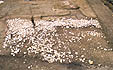 2/20
2/20
 2/17
2/17
 2/18
2/18
 2/16
2/16 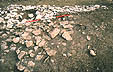 2/15
2/15 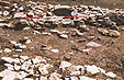 2/14
2/14
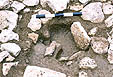
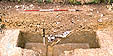
At the internal corner of the bank the walkway incorporated a single large post-hole, filled with dark clayey earth [2/19]. It was 0.28 x 0.40m in width and 0.20m in depth from the surface of the walkway, and defined with packing stones set on edge. This is interpreted as one of two main supports of the rear of a wooden turret or tower set into the corner of the bank, possibly incorporating palisading along the crest of the bank. If the turret was built symmetrically in relation to the bank, the second of the two posts would have been located at a point which was disturbed by the recent insertion of a field drain [2/20, 2/21, 2/22].
 2/19
2/19
The two inner ditches were observed on both the southern and western sides of the bank [1/3], and the outer ditch in one place on the western side (Area 2c, machine-cut trench 5 - see Figure 4). The two inner ditches had been recut on at least two occasions (periods 2A and 2C) and filled again (periods 2B, 3A and 4A), and so in very few places retained much semblance of their original profile in section. The outer ditch, however, showed no sign of a recut. Although they could not be related stratigraphically either to each other or to any other elements of the first phase defensive system, it must be inferred that the clay derived from their excavation provided the material for the initial construction of the bank.
.jpg) 1/3
1/3
Inner ditch - The inner ditch was separated from the original front of the bank by a berm between 5.5 and 6.5m wide. This feature was observed in Area 1 - section 1, Area 2 - section 3, Area 2 - section 4, Area 2 - section 6 and Area 3 - section 7
In other places in Area 1 it was observed in plan. It was also excavated in another machine-dug trench on the south side of Area 3 (Figure 4). An anomaly, however, was its absence in a deep trench on the south-western side of Area 2, partly dug by machine at the end of the excavation (Area 2B), to explore its course around the corner of the defensive bank.
In all places (except Area 2, section 4) it was filled with stones with some mortar, with no underlying layers of silting [3/4, 3/1, 3/12; 2/33, 2/38, 2/34, 2/29, 2/30; 1/4, 1/5, 1/3]. Since it is likely that this stone and mortar fill represents period 3 destruction deposits of the wall, probably more than a century after the original construction of the ditch, it must have been cleaned out or re-excavated more than once. The re-excavation of the defensive ditches would be expected during the reconstruction of the front of the defences in stone in period 2A, as well as some time later in the period of refurbishment of the defences in period 2C. It is likely that its profile would have been considerably modified before period 3 by both natural erosion and artificial scouring. This process must explain the considerable variation in the profiles of the ditch in the various places it was exposed (see especially section 6 and section 7). Natural erosion of the inner berm was demonstrated in trench 2, where a thick deposit of clay, silt and gravel filled an erosion hollow.
 3/4
3/4
 3/1
3/1
 3/12
3/12
 2/33
2/33 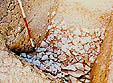 2/38
2/38 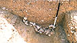 2/34
2/34
 2/29
2/29 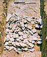 2/30
2/30
.jpg) 1/4
1/4 .jpg) 1/5
1/5
Centre ditch - This was observed in Area 1 - section 1, Area 2 - section 6 and Area 3 - section 7.
In Area 1 this ditch was partially filled with stones, but in other places filled with clay distinguishable from the natural Oxford clay only by the occasional presence of snails and by its differential drying in section. The uneven profiles of this ditch observed on the west side (section 6 and section 7) were probably also caused by erosion [3/2; 2/32]. A layer of disturbed oxidised clay [553 - not shown in section 7] on the central berm in Areas 2 and 3 can be interpreted as the remains of the silt derived from the cleaning out of the two inner ditches and spread onto the berm, probably in period 2A.
1/3
 1/12
1/12
 2/32
2/32
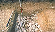
Outer ditch - This was located only in the machine-cut trench 4, Area 4, on the west side of the defences. If it originally existed on the south side it had been destroyed by the railway cutting (Figure 4). It was a steep-sided ditch with a flat bottom, 1.3m in depth (no deeper than the two inner ditches) and 10.5m in width at ground surface level, and filled with blue clay almost indistinguishable from the natural Oxford clay. Its lowest layers contained a few snail shells and small Oolitic Limestone pebbles [2/13, 2/28]. There was no recognisable sign of any recut. It can be inferred from the cleanliness of its fill, which contrasts markedly with the dark brown earthy fill of the 12th century ditch of Period 4 (below), that it was cut, and became silted up, soon after the surrounding area had been stripped of turf and before more topsoil had had a chance to form; it therefore belongs to the primary defensive system. That it belongs to period 1 is further suggested by the fact that an excavation of this magnitude would have been necessary to provide the volume of clay for the initial construction of the bank.
 2/13
2/13
 2/28
2/28
Summary | Period 0-1 | Period 2 | Period 3 | Period 4-5
© Internet Archaeology
URL: http://intarch.ac.uk/journal/issue14/1/excavations-per0-1.htm
Last updated: Mon Jul 7 2003